Introduction
Legend is
an exploration company actively exploring and developing phosphate projects in
the Georgina Basin in North West Queensland, Australia.
The
purpose of this report is to release an update of the exploration drilling and
preliminary metallurgical results on the D-Tree project. The majority of holes
have results returned from the assay laboratory and will be used to inform any
future Probable or Proven Mineral Reserve estimates in conjunction with
appropriate mining, metallurgical, economic, marketing, legal, environmental,
social and governmental modifying factors.
The D-Tree
project is a known phosphate deposit which contains historical non reserve
mineralization reported within publically available documentation2. These
historical estimates are not Mineral Reserve estimates as defined by SEC
Industry Guidelines. Legend has confidence in these reports of non-reserve
mineralized material and which have been used as an ‘exploration target’. The
drilling results reported in this document confirm historical drilling results
(drilled by IMC Development Corporation since 1967) and the presence of a
significant phosphate deposit. These results will inform any future estimates of
Mineral Reserves.
This
report only covers drilling and metallurgical work conducted on EPM14753 (See
Figure 1). Other granted landholdings in the D-Tree Project (see Table 1) will
be drilled later in this quarter. Legend’s flagship project known as the Lady
Annie Phosphate Project is expected to have exploration permits granted in the
3rd
quarter of this year and these areas will be aggressively drilled and
metallurgically tested at that time.
Tenure
The D-Tree
tenement (EPM14753) covers 16,730 acres and was granted on 21 April 2008. The
tenement forms part of the D-Tree Project with the other tenements as listed in
Table 1.
|
Tenement
|
Status
|
Date
|
Area
(acres)
|
Legend
Interest
|
||||||
|
EPM14753
|
Granted
|
21/04/2008
|
16,730 | 80 | %* | |||||
|
EPM15763
|
Granted
|
13/03/2008
|
63,000 | 80 | %* | |||||
|
EPM17333
|
Application
|
5/02/2008
|
30,300 | 80 | %* | |||||
|
EPM17446
|
Application
|
3/03/2008
|
5,580 | 80 | %* | |||||
|
EPM17443
|
Application
|
3/03/2008
|
3,190 | 80 | %* | |||||
|
EPM17437
|
Application
|
3/03/2008
|
1,590 | 80 | %* | |||||
|
*
Heads of Agreement to form a Joint Venture with Mt Isa Metals Ltd. for
Legend having 80% interest and Mt Isa Metals Ltd 20%.
|
||||||||||
Table 1:
Tenement list and standing for D-Tree Project
Legend
currently has access to two granted exploration tenements in the area and
another four under application for the project. Native title advertisements were
placed in local papers in January 2009 for the Thorntonia (EPM17333) and Epsom
Creek (EPM17446) tenement applications, which constitutes the beginning of a
four month statutory advertising timeframe before the exploration permit can be
granted.
Access
During the
second half of 2008, Legend embarked on an extensive drilling program of the
D-Tree deposit which is located 125 kilometers from the regional centre of Mt
Isa. Site access is relatively easily achieved by driving 110
kilometers along the sealed Barkly Highway, followed by driving 40 kilometres
along the sealed Thorntonia-Yelvertoft Road. The last part is 22 kilometres
along an existing and developed access road (See Figure 1).
1 Joint
Ore Reserve Committee Guide for the reporting of Exploration Results, Mineral
Resources and Ore Reserves. This Guide is also comparable to the Society of
Mining, Metallurgy and Exploration, Inc. (SME) 2005 guide for reporting
Exploration Results, Mineral Resources, and Mineral Reserves.
2 Denaro,
T, Ramsden, C, & Brown, D. ‘Queensland Minerals A Summary of Major Mineral
Resources, Mines and Projects, 4th Edition). Queensland Government Department of
Mines & Energy, 2007
2
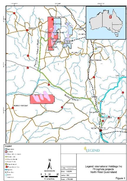
Figure 1:
Access to the D-Tree Deposit
3
Geology
The D-Tree
deposit comprises Cambrian Sediments and sits on the eastern edge of the
regional Georgina Basin. The mineralization that forms the phosphate deposit is
known as phosphorite which is a marine sedimentary unit within the Beetle Creek
Formation. Underlying the Beetle Creek Formation is the Mount Hendry Formation
which is made up of conglomerates, siltstones and sandstones. In some areas the
Beetle Creek Formation unconformably overlies an un-named Pre-Cambrian unit that
is easily identified in geological logging. Overlying the Beetle Creek Formation
is either the Inca Creek formation made predominately of chert rich siltstones,
or the Thorntonia Limestone.
All
drilling information has been recorded and logged by Legend’s geologists. This
information will form part of a detailed geological model of the
deposit.
Drilling
and Sampling Methodology
The
phosphate drilling program was drilled on a nominal 300 metre by 300 metre grid
pattern. Some areas, such as the Galah Creek area were drilled on a 100 metre by
100 metre spacing to better define the areas of higher grade.
Three
types of drilling have been conducted in the deposit to date. Reverse
Circulation (RC) drilling is used as the base for all results reported in this
document and is the most extensive type of drilling. The second type is Diamond
drilling, which mainly consists of holes to twin current RC drilling for quality
control purposes. A third type, Sonic drilling was also used to obtain larger
samples which are appropriate for metallurgical sampling and testing. Sonic
drilling uses an ultra-high frequency oscillating drill bit to cut through the
rock giving full sample recovery as there is no high pressure air or water
required in the process.
All RC
samples were collected using a 3-tier riffle splitter over 1 meter intervals,
yielding a 2-3 kg sample for subsequent assaying. A second split has also been
collected from some high grade intervals to use in quality assurance of the
sampling process. Assay results from all such field duplicate samples received
so far show very good correlation between assays from original and duplicate
samples.
The RC
holes drilled have been completed using either a 4.5” (114.3mm) or 5” (127mm)
drill bit. All Diamond core has been drilled at HQ triple tube size and Sonic
core was drilled at 6” (152mm) drill bit. Sample recoveries for the diamond
drilling have been logged and recorded.
All
phosphate samples have been submitted to either one of two commercial
laboratories located in either Mt Isa or Brisbane. The analytical technique used
was fused bead XRF, but some samples were also tested using a fused bead ICP
method for comparison. All samples were analyzed for P2O5, Al2O3, Fe2O3, MgO, CaO
and SiO2.
A series
of pulp duplicates were taken at the preparation stage to test for laboratory
accuracy and precision with all results showing good correlation and within
acceptable limits. A series of matrix matched phosphate reference standards have
also been submitted with the samples to ensure accuracy and precision of
assaying. The results of these standards came back within acceptable
limits.
Results
Legend has
received results for 470 of the 476 RC holes drilled. A total of 12,520 metres
of drilling is complete with results received so far totalling approximately
12,100 assays.
For all RC
drilling a total of more than 250 holes have an intercept of greater than 8%
P2O5. As some
holes have up to 3 separate intercepts at this grade there is a total of 332
intervals representing three main identified zones within the Project area (see
Figure 2). All intercept results were calculated with an 8% minimum P2O5 cut,
minimum 2 metre intercept and maximum of 2 metres contiguous internal dilution
and are listed in Appendix A.
4
Table 3
shows all significant intercepts of greater than 25% P2O5. All
drilling has been done with vertical holes which, as the deposit is nominally
flat lying gives a true width for each mineralized zone. These zones were
calculated using a minimum width of two metres and a maximum internal dilution
of two contiguous metres. See Appendix A for collar coordinates of these holes.
This table represents the drill intercepts that have the greatest potential for
delivering high grade direct shipping ore or material that requires little dry
beneficiation through crushing, screening or magnetic separation. These high
grade zones are clustered in two main areas, North D-Tree and Galah Creek as
depicted in figure 2.
Two
east-west cross sections through the deposit are also shown in figure 3. The
section lines chosen are depicted on figure 2. The sections show the
mineralization continuity over east-west widths of 2-3 kilometres and figure 2
shows the continuity in the north-south direction of well over 10 km. These
diagrams clearly show the massive extent of the D-Tree mineralization and
therefore the approximate magnitude of an exploration target that may exist
within any given part of the overall phosphate deposit area. The deposit is
known from historical drilling to extend in north, south and west directions
into other landholdings granted or under application by Legend which combine to
form the D-Tree project. The D-Tree project currently has a Heads of Agreement
in place to form a Joint Venture with Mt Isa Metals Ltd whereby Legend will hold
an 80% interest.
5
|
Hole_ID
|
From
(m)
|
To
(m)
|
Width
(m)
|
P2O5 | % |
Fe2O3
%
|
Al2O3
%
|
*R2O3 | % |
MgO
%
|
SiO2
%
|
CaO
%
|
CaO:P2O5
Ratio
|
|||||||||||||||||||||||||||||||
|
DTRC0034
|
1 | 3 | 2 | 25.80 | 5.80 | 2.05 | 7.85 | 0.15 | 27.80 | 34.95 | 1.35 | |||||||||||||||||||||||||||||||||
|
DTRC0053
|
2 | 5 | 3 | 30.67 | 5.50 | 2.50 | 8.00 | 0.10 | 6.87 | 40.97 | 1.34 | |||||||||||||||||||||||||||||||||
|
DTRC0076
|
6 | 9 | 3 | 28.60 | 5.50 | 3.37 | 8.87 | -0.03 | 18.43 | 38.23 | 1.34 | |||||||||||||||||||||||||||||||||
|
DTRC0076
|
15 | 17 | 2 | 30.50 | 2.35 | 2.05 | 4.40 | 0.00 | 18.85 | 41.35 | 1.36 | |||||||||||||||||||||||||||||||||
|
DTRC0083
|
27 | 29 | 2 | 33.85 | 1.50 | 1.75 | 3.25 | 0.20 | 11.18 | 46.10 | 1.36 | |||||||||||||||||||||||||||||||||
|
DTRC0090
|
10 | 12 | 2 | 26.45 | 4.35 | 2.85 | 7.20 | 0.25 | 23.45 | 36.30 | 1.37 | |||||||||||||||||||||||||||||||||
|
DTRC0098
|
9 | 11 | 2 | 32.30 | 0.35 | 2.00 | 2.35 | 0.20 | 15.34 | 44.20 | 1.37 | |||||||||||||||||||||||||||||||||
|
DTRC0112
|
27 | 30 | 3 | 28.87 | 1.77 | 2.10 | 3.87 | 0.13 | 23.00 | 39.43 | 1.37 | |||||||||||||||||||||||||||||||||
|
DTRC0113
|
13 | 15 | 2 | 27.60 | 4.05 | 2.95 | 7.00 | 0.20 | 22.15 | 37.50 | 1.36 | |||||||||||||||||||||||||||||||||
|
DTRC0127
|
20 | 23 | 3 | 27.87 | 1.87 | 4.23 | 6.10 | 0.23 | 23.70 | 37.77 | 1.36 | |||||||||||||||||||||||||||||||||
|
DTRC0132
|
15 | 17 | 2 | 29.55 | 2.85 | 2.69 | 5.54 | 0.17 | 20.45 | 39.85 | 1.35 | |||||||||||||||||||||||||||||||||
|
DTRC0133
|
13 | 16 | 3 | 27.20 | 10.73 | 2.97 | 13.70 | 0.20 | 17.13 | 36.83 | 1.35 | |||||||||||||||||||||||||||||||||
|
DTRC0133
|
28 | 31 | 3 | 26.93 | 5.97 | 3.60 | 9.57 | 0.23 | 20.83 | 36.70 | 1.36 | |||||||||||||||||||||||||||||||||
|
DTRC0139
|
23 | 25 | 2 | 26.75 | 4.45 | 2.85 | 7.30 | 0.25 | 24.10 | 36.30 | 1.36 | |||||||||||||||||||||||||||||||||
|
DTRC0147
|
8 | 12 | 4 | 30.22 | 0.45 | 2.83 | 3.28 | 0.20 | 19.95 | 41.02 | 1.36 | |||||||||||||||||||||||||||||||||
|
DTRC0148
|
6 | 8 | 2 | 27.50 | 2.55 | 4.05 | 6.60 | 0.20 | 22.70 | 37.30 | 1.36 | |||||||||||||||||||||||||||||||||
|
DTRC0157
|
12 | 14 | 2 | 33.65 | 2.70 | 3.04 | 5.74 | 0.12 | 9.35 | 45.90 | 1.36 | |||||||||||||||||||||||||||||||||
|
DTRC0158
|
14 | 16 | 2 | 29.20 | 5.23 | 2.66 | 7.89 | 0.14 | 18.65 | 39.45 | 1.35 | |||||||||||||||||||||||||||||||||
|
DTRC0188
|
4 | 8 | 4 | 29.48 | 1.80 | 4.80 | 6.60 | 0.52 | 18.29 | 40.15 | 1.36 | |||||||||||||||||||||||||||||||||
|
DTRC0212
|
17 | 20 | 3 | 32.30 | 14.43 | 0.77 | 15.20 | 0.03 | 2.93 | 43.37 | 1.34 | |||||||||||||||||||||||||||||||||
|
DTRC0244
|
4 | 6 | 2 | 32.55 | 0.90 | 2.00 | 2.90 | 0.15 | 15.65 | 43.85 | 1.35 | |||||||||||||||||||||||||||||||||
|
DTRC0258
|
18 | 20 | 2 | 34.55 | 4.35 | 2.20 | 6.55 | 0.00 | 5.87 | 45.85 | 1.33 | |||||||||||||||||||||||||||||||||
|
DTRC0292
|
14 | 16 | 2 | 30.60 | 7.00 | 3.30 | 10.30 | 0.05 | 12.21 | 40.70 | 1.33 | |||||||||||||||||||||||||||||||||
|
DTRC0300
|
7 | 9 | 2 | 30.40 | 9.26 | 2.34 | 11.60 | 0.13 | 11.98 | 41.25 | 1.36 | |||||||||||||||||||||||||||||||||
|
DTRC0302
|
7 | 9 | 2 | 28.40 | 12.55 | 4.38 | 16.93 | 0.17 | 10.86 | 37.45 | 1.32 | |||||||||||||||||||||||||||||||||
|
DTRC0338
|
16 | 18 | 2 | 26.80 | 6.17 | 3.93 | 10.10 | 0.20 | 21.15 | 36.05 | 1.35 | |||||||||||||||||||||||||||||||||
|
DTRC0339
|
11 | 13 | 2 | 27.65 | 4.28 | 5.70 | 9.98 | 0.18 | 19.00 | 37.20 | 1.35 | |||||||||||||||||||||||||||||||||
|
DTRC0352
|
13 | 16 | 3 | 34.47 | 1.77 | 2.01 | 3.78 | 0.07 | 11.30 | 46.70 | 1.35 | |||||||||||||||||||||||||||||||||
|
DTRC0375
|
13 | 15 | 2 | 28.20 | 16.30 | 2.30 | 18.60 | 0.15 | 10.01 | 37.60 | 1.33 | |||||||||||||||||||||||||||||||||
|
DTRC0384
|
19 | 21 | 2 | 34.75 | 5.21 | 1.53 | 6.74 | 0.10 | 6.02 | 47.85 | 1.38 | |||||||||||||||||||||||||||||||||
|
DTRC0387
|
8 | 10 | 2 | 28.05 | 23.02 | 2.20 | 25.22 | 0.15 | 3.09 | 37.60 | 1.34 | |||||||||||||||||||||||||||||||||
|
DTRC0432
|
2 | 4 | 2 | 26.40 | 5.78 | 3.40 | 9.18 | 0.20 | 22.95 | 35.75 | 1.35 | |||||||||||||||||||||||||||||||||
|
DTRC0451
|
14 | 16 | 2 | 33.55 | 1.20 | 1.61 | 2.81 | 0.07 | 14.73 | 45.50 | 1.36 | |||||||||||||||||||||||||||||||||
|
DTRC0461
|
3 | 5 | 2 | 27.95 | 17.40 | 1.51 | 18.91 | 0.21 | 8.11 | 38.15 | 1.36 | |||||||||||||||||||||||||||||||||
|
DTRC0463
|
11 | 15 | 4 | 35.92 | 6.54 | 1.29 | 7.83 | 0.10 | 3.54 | 48.60 | 1.35 | |||||||||||||||||||||||||||||||||
|
DTRC0472
|
13 | 15 | 2 | 31.35 | 12.46 | 1.29 | 13.75 | 0.13 | 6.26 | 43.10 | 1.37 | |||||||||||||||||||||||||||||||||
|
Min
|
25.80 | 0.35 | 0.77 | 2.35 | -0.03 | 2.93 | 34.95 | 1.32 | ||||||||||||||||||||||||||||||||||||
|
Max
|
35.92 | 23.02 | 5.70 | 25.22 | 0.52 | 27.80 | 48.60 | 1.38 | ||||||||||||||||||||||||||||||||||||
|
Weighted
Average
|
30.02 | 5.95 | 2.51 | 8.75 | 0.15 | 16.90 | 39.36 | 1.35 | ||||||||||||||||||||||||||||||||||||
Table 3:
Significant intercepts >25% P2O5,
calculated using 25% P2O5 cut,
minimum width of 2 metres and maximum contiguous dilution of 2 metres. *R2O5 = Fe2O3 + Al2O3
6
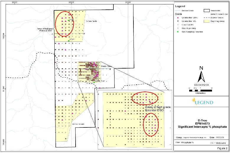
Figure 2:
Map showing significant intercept locations for the D-Tree Project
7
Figure 3:
Cross-Sections through D-Tree North (A-A’) and Galah Creek (B-B’)
8
Metallurgy
Five large
samples of phosphate rock were collected at D-Tree from two historic trenches
and one small pit, YT-27, YT-141 and Galah Pit 3; these sites can be seen on
figure 2. These trenches and pits were excavated in the 1970’s by IMC
Development Corporation for beneficiation testwork. The Legend samples were
collected using hand tools (jack hammer and picks) and weighed around 400kg each
when shipped.
These five
samples are from 3 localised areas within the D-Tree deposit as shown on figure
2 and are not necessarily representative of the entire deposit.
Phosphate
rock beneficiation tests on YT27 and YT141 samples have been completed at bench
scale using standard comminution and flotation techniques. The beneficiation
process consisted of crushing, grinding, scrubbing to remove the -20 micron
fraction and flotation. A coarse fraction consisting of particle size
- -1.18mm to +150 micron and a fine fraction of -150 micron to +20 micron were
floated separately giving excellent concentrate grades. Results are
tabulated below.
|
Concentrate
Sample
|
|||||||||||||||||||||||||||||||||
|
YT-27
|
YT-27(Fe)
|
YT-141
|
YT-141(Fe)
|
||||||||||||||||||||||||||||||
|
Constituent
|
Coarse
|
Fine
|
Coarse
|
Fine
|
Coarse
|
Fine
|
Coarse
|
Fine
|
|||||||||||||||||||||||||
| P2O5 % | 32.13 | 34.10 | 33.66 | 33.65 | 38.61 | 36.04 | 38.95 | 36.09 | |||||||||||||||||||||||||
|
Fe2O3
%
|
0.84 | 0.40 | 0.53 | 0.37 | 0.24 | 0.58 | 1.61 | 4.96 | |||||||||||||||||||||||||
|
Acid
Insol %
|
12.20 | 10.12 | 13.16 | 8.06 | 3.29 | 6.20 | 2.29 | 4.17 | |||||||||||||||||||||||||
|
Flotation
Recovery %
|
67.6 | 76.0 | 89.9 | 87.3 | 69.1 | 91.3 | 41.5 | 89.2 | |||||||||||||||||||||||||
Table 2:
Results from metallurgical test-work
Legend is
currently assessing methods of recovering the ultrafine particle fraction (minus
20 micron) using flotation, so that the entire range of particle sizes may be
considered as feed to the processing plant. Further test-work is planned using
specialised ultrafine particle flotation techniques to increase the phosphate
grade and recovery to the concentrate, while optimising iron
rejection.
The sample
from Galah Creek (Galah Pit 3 on figure 2 below) is an example of potential
direct shipping ore. The sample required no beneficiation and when
assayed gave results of 38.7% P2O5 and 1.4%
combined Fe2O3 and
Al2O3.
In partial
areas of the D-Tree deposit the elements of iron (Fe2O3) and
aluminium (Al2O3) have been
identified (in consultation with Legends customer and partner IFFCO (Indian
Farmers Fertiliser Cooperative)) as possible deleterious elements which may
affect the phosphoric acid manufacturing process. The levels of these elements
need to be within a certain range and the maximum and minimum limits will be
identified in future phosphoric acid tests. Control of these contaminants will
be addressed through either selective mining such as areas in part of North
D-Tree, which have been identified as having lower levels of these elements, or
by using common dry beneficiation techniques such as crushing, screening, ore
sorting or magnetic separation. Each phosphate rock deposit around the world is
unique and will have its own limits on the levels of deleterious elements which
can be acceptable in the phosphoric acid manufacturing process. Individual
phosphoric acid plants will also have their own unique specifications. Legend
has an advantage in this regard as it has formed a clear expectation as to which
plant will be taking its phosphate rock which will be IFFCO’s Paradeep Unit in
India. This means testwork on the rock in the near term will be aimed at meeting
the Paradeep plants individual requirements.
Trace
elements and other impurities such as (but not limited to) cadmium, uranium,
lead, fluorine, sodium and magnesium have been tested throughout the deposit and
found to exist in quantities that are insignificant to both Legend’s customer
and partner IFFCO and in general when compared to other phosphate rock from
around the world.
Future
Work
Legend
will use these results to develop an estimate of the non-reserve mineralized
deposit, that is compliant with Australian JORC 2004 and United States SME 2005
guidelines. This estimate will form part of the preliminary work that will be
used to inform any future estimates of Probable or Proven Mineral Reserves for
the D-Tree Project in conjunction with appropriate mining, metallurgical,
economic, marketing, legal, environmental, social and governmental modifying
factors. Other work will include further drilling around some of the higher
grade areas to test for possible direct shipping ore (DSO) or material that
requires little dry beneficiation such as crushing, screening or magnetic
separation.
Review
This work
has been reviewed by Stephen Hyland - BSc (Geology), MAusIMM, GAA, CIMM who is a
competent person as required under the JORC and SME guidelines.
Stephen
Hyland has over 20 years experience in exploration geology and resource
modelling and has worked extensively within Australia as well as offshore in
Africa, Eastern and Western Europe, Central and South East Asia, modelling base
metals, gold, precious metals and industrial minerals. Stephen’s extensive
resource modelling experience commenced whilst working with Eagle Mining
Corporation NL in the diverse and complex Yandal Gold Province where for three
and half years he was their Principal Resource Geologist. Whilst the majority of
his time there had been developing the historically successful Nimary Mine, he
also assisted the regional exploration group with preliminary resource
assessment of Eagle’s numerous exploration and mining leases. Since 1997 Stephen
has been a full time Consultant with the minerals consulting firm Ravensgate
where he is responsible for all geological modelling and reviews, mineral
deposit evaluation, computational modelling, resource estimation, resource
reporting for ASX / JORC and other regulatory compliance areas. Primarily
Stephen specialises in Geological and Resource Block Modelling generally with
the widely used MedSystem / Minesight 3D mine-evaluation and design software.
Stephen Hyland holds the relevant qualifications and professional associations
required by the ASX, JORC and ValMin Codes in Australia. He is a Qualified
Person under the rules of the CIMM and NI43-101.
Forward-Looking
Statements
Forward-looking
statements in this prospectus supplement release are made pursuant to the “safe
harbour” provisions of the Private Securities Litigation Reform Act of 1995.
Investors are cautioned that such forward-looking statements involve risks and
uncertainties including, without limitation, the risks of exploration and
development stage projects, risks associated with environmental and other
regulatory matters, mining risks and competition and the volatility of mineral
prices. Actual results and timetables could vary significantly. Additional
information about these and other factors that could affect the Company’s
business is set forth in the Prospectus and other filings with the Securities
and Exchange Commission.
APPENDIX
A
|
Hole_ID
|
Easting
(WGS
84)
|
Northing
(WGS
84)
|
Intercept
P2O5 (%)
|
Area
|
||||||
|
DTRC0001
|
283594 | 7818104 |
6m @
15.86% from 30m
|
D-Tree
|
||||||
|
DTRC0001
|
283594 | 7818104 |
3m @
10.43% from 40m
|
D-Tree
|
||||||
|
DTRC0002
|
283901 | 7818098 |
2m @
17.7% from 4m
|
D-Tree
|
||||||
|
DTRC0002
|
283901 | 7818098 |
3m @
15.33% from 14m
|
D-Tree
|
||||||
|
DTRC0003
|
284199 | 7818099 |
6m @
17.87% from 11m
|
D-Tree
|
||||||
|
DTRC0003
|
284199 | 7818099 |
5m @
13.22% from 20m
|
D-Tree
|
||||||
|
DTRC0003
|
284199 | 7818099 |
2m @
12.59% from 29m
|
D-Tree
|
||||||
|
DTRC0004
|
284499 | 7818097 |
12m
@ 12.77% from 13m
|
D-Tree
|
||||||
|
DTRC0005
|
284798 | 7818099 |
4m @
11.42% from 0m
|
D-Tree
|
||||||
|
DTRC0005
|
284798 | 7818099 |
7m @
13.08% from 12m
|
D-Tree
|
||||||
|
DTRC0005
|
284798 | 7818099 |
2m @
11.99% from 22m
|
D-Tree
|
||||||
|
DTRC0006
|
285400 | 7818099 |
11m
@ 10.07% from 8m
|
D-Tree
|
||||||
|
DTRC0009
|
285102 | 7818101 |
8m @
13.31% from 0m
|
D-Tree
|
||||||
|
DTRC0009
|
285102 | 7818101 |
5m @
14.62% from 13m
|
D-Tree
|
||||||
|
DTRC0009
|
285102 | 7818101 |
3m @
12.66% from 23m
|
D-Tree
|
||||||
|
DTRC0011
|
283603 | 7817497 |
4m @
11.76% from 22m
|
D-Tree
|
||||||
|
DTRC0013
|
284200 | 7817500 |
2m @
11.7% from 17m
|
D-Tree
|
||||||
|
DTRC0013
|
284200 | 7817500 |
4m @
13.28% from 22m
|
D-Tree
|
||||||
|
DTRC0014
|
284498 | 7817500 |
3m @
9.69% from 8m
|
D-Tree
|
||||||
|
DTRC0017
|
285401 | 7817498 |
2m @
10.6% from 12m
|
D-Tree
|
||||||
|
DTRC0018
|
285698 | 7817501 |
5m @
9.9% from 15m
|
Galah
Creek
|
||||||
|
DTRC0019
|
285999 | 7817503 |
3m @
11.74% from 9m
|
Galah
Creek
|
||||||
|
DTRC0019
|
285999 | 7817503 |
2m @
12.8% from 16m
|
Galah
Creek
|
||||||
|
DTRC0021
|
286599 | 7817497 |
2m @
13.09% from 7m
|
Galah
Creek
|
||||||
|
DTRC0023
|
287197 | 7817498 |
3m @
18.48% from 9m
|
Galah
Creek
|
||||||
|
DTRC0026
|
283900 | 7816900 |
2m @
10.89% from 6m
|
D-Tree
|
||||||
|
DTRC0027
|
284200 | 7816900 |
14m
@ 10.5% from 5m
|
D-Tree
|
||||||
|
DTRC0028
|
284500 | 7816900 |
3m @
10.4% from 7m
|
D-Tree
|
||||||
|
DTRC0028
|
284500 | 7816900 |
2m @
13.25% from 11m
|
D-Tree
|
||||||
|
DTRC0028
|
284500 | 7816900 |
4m @
12.87% from 16m
|
D-Tree
|
||||||
|
DTRC0029
|
284800 | 7816900 |
2m @
14.4% from 14m
|
D-Tree
|
||||||
|
DTRC0030
|
285100 | 7816900 |
3m @
10.42% from 5m
|
D-Tree
|
||||||
|
DTRC0030
|
285100 | 7816900 |
2m @
8.6% from 11m
|
D-Tree
|
||||||
|
DTRC0030
|
285100 | 7816900 |
2m @
8.4% from 19m
|
D-Tree
|
||||||
|
DTRC0031
|
285400 | 7816900 |
4m @
14.5% from 5m
|
D-Tree
|
||||||
|
DTRC0031
|
285400 | 7816900 |
3m @
9.79% from 11m
|
D-Tree
|
||||||
|
DTRC0032
|
285700 | 7816900 |
5m @
17.02% from 9m
|
Galah
Creek
|
||||||
|
DTRC0032
|
285700 | 7816900 |
4m @
18.5% from 19m
|
Galah
Creek
|
||||||
|
Hole_ID
|
Easting
(WGS
84)
|
Northing
(WGS
84)
|
Intercept
P2O5 (%)
|
Area
|
|||||||
|
DTRC0034
|
286300 | 7816900 | 3m @ 20.46% from 1m inc 2m @ 25.8% from 1m |
Galah
Creek
|
|||||||
|
DTRC0035
|
286600 | 7816900 |
4m @
10.79% from 12m
|
Galah
Creek
|
|||||||
|
DTRC0036
|
286900 | 7816900 |
4m @
14.02% from 8m
|
Galah
Creek
|
|||||||
|
DTRC0044
|
284500 | 7816300 |
4m @
10.1% from 1m
|
D-Tree
|
|||||||
|
DTRC0045
|
284800 | 7816300 |
7m @
12.06% from 9m
|
D-Tree
|
|||||||
|
DTRC0047
|
285400 | 7816300 |
2m @
14.58% from 7m
|
D-Tree
|
|||||||
|
DTRC0048
|
285700 | 7816300 |
3m @
19.3% from 15m
|
Galah
Creek
|
|||||||
|
DTRC0051
|
286600 | 7816300 |
2m @
13.36% from 10m
|
Galah
Creek
|
|||||||
|
DTRC0053
|
287200 | 7816300 | 5m @ 27.56% from 2m inc 3m @ 30.67% from 2m |
Galah
Creek
|
|||||||
|
DTRC0057
|
283600 | 7815700 |
2m @
8.83% from 11m
|
D-Tree
|
|||||||
|
DTRC0066
|
286300 | 7815700 |
6m @
14.38% from 0m
|
Galah
Creek
|
|||||||
|
DTRC0073
|
283601 | 7818701 |
4m @
12.83% from 39m
|
D-Tree
|
|||||||
|
DTRC0073
|
283601 | 7818701 |
2m @
12.5% from 51m
|
D-Tree
|
|||||||
|
DTRC0074
|
283901 | 7818700 |
2m @
9.82% from 30m
|
D-Tree
|
|||||||
|
DTRC0075
|
284196 | 7818702 |
4m @
17.42% from 5m
|
D-Tree
|
|||||||
|
DTRC0076
|
284492 | 7818700 | 14m @ 21.31% from 4m inc 2m @ 30.5% from 15m |
D-Tree
|
|||||||
|
DTRC0078
|
285074 | 7818691 |
3m @
11.91% from 6m
|
D-Tree
|
|||||||
|
DTRC0079
|
285401 | 7818700 |
4m @
10.62% from 0m
|
D-Tree
|
|||||||
|
DTRC0082
|
283600 | 7819300 |
6m @
15.47% from 33m
|
D-Tree
|
|||||||
|
DTRC0083
|
283904 | 7819287 | 7m @ 17.25% from 26m inc 2m @ 33.85% from 27m |
D-Tree
|
|||||||
|
DTRC0083
|
283904 | 7819287 |
5m @
9.79% from 38m
|
D-Tree
|
|||||||
|
DTRC0085
|
284498 | 7819304 |
3m @
16.6% from 9m
|
D-Tree
|
|||||||
|
DTRC0085
|
284498 | 7819304 |
4m @
17.63% from 23m
|
D-Tree
|
|||||||
|
DTRC0087
|
285112 | 7819307 |
3m @
11.77% from 0m
|
D-Tree
|
|||||||
|
DTRC0090
|
283597 | 7819895 | 5m @ 17.78% from 10m inc 2m @ 26.45% from 10m |
North
D-Tree
|
|||||||
|
DTRC0091
|
283904 | 7819902 |
8m @
13.42% from 15m
|
North
D-Tree
|
|||||||
|
DTRC0092
|
284203 | 7819892 |
5m @
16.5% from 13m
|
North
D-Tree
|
|||||||
|
DTRC0092
|
284203 | 7819892 |
4m @
9.04% from 28m
|
North
D-Tree
|
|||||||
|
DTRC0093
|
284518 | 7819888 |
7m @
12.8% from 13m
|
North
D-Tree
|
|||||||
|
DTRC0093
|
284518 | 7819888 |
3m @
13.17% from 24m
|
North
D-Tree
|
|||||||
|
DTRC0094
|
284805 | 7819901 |
2m @
13.4% from 6m
|
North
D-Tree
|
|||||||
|
DTRC0094
|
284805 | 7819901 |
2m @
15.9% from 17m
|
North
D-Tree
|
|||||||
|
DTRC0098
|
284204 | 7820503 | 19m @ 17.66% from 9m inc 2m @ 32.3% from 9m |
North
D-Tree
|
|||||||
|
DTRC0099
|
284485 | 7820506 |
2m @
14.15% from 2m
|
North
D-Tree
|
|||||||
|
DTRC0099
|
284485 | 7820506 |
5m @
12.35% from 10m
|
North
D-Tree
|
|||||||
|
DTRC0100
|
284799 | 7820500 |
2m @
16% from 4m
|
North
D-Tree
|
|||||||
|
DTRC0100
|
284799 | 7820500 |
2m @
9.63% from 7m
|
North
D-Tree
|
|||||||
|
DTRC0100
|
284799 | 7820500 |
5m @
11.28% from 12m
|
North
D-Tree
|
|||||||
|
DTRC0105
|
284204 | 7821092 |
4m @
20.79% from 12m
|
North
D-Tree
|
|||||||
|
Hole_ID
|
Easting
(WGS
84)
|
Northing
(WGS
84)
|
Intercept
P2O5 (%)
|
Area
|
|||||||
|
DTRC0105
|
284204 | 7821092 |
5m @
16.19% from 24m
|
North
D-Tree
|
|||||||
|
DTRC0106
|
284493 | 7821101 |
4m @
18.73% from 23m
|
North
D-Tree
|
|||||||
|
DTRC0107
|
284800 | 7821100 |
6m @
17.72% from 11m
|
North
D-Tree
|
|||||||
|
DTRC0108
|
285106 | 7821102 |
10m
@ 17.67% from 0m
|
North
D-Tree
|
|||||||
|
DTRC0112
|
284196 | 7821699 |
3m @
19.9% from 14m
|
North
D-Tree
|
|||||||
|
DTRC0112
|
284196 | 7821699 | 5m @ 22.24% from 25m inc 3m @ 28.87% from 27m |
North
D-Tree
|
|||||||
|
DTRC0113
|
284512 | 7821711 | 4m @ 19.55% from 13m inc 2m @ 27.6% from 13m |
North
D-Tree
|
|||||||
|
DTRC0113
|
284512 | 7821711 |
9m @
14.76% from 26m
|
North
D-Tree
|
|||||||
|
DTRC0114
|
284802 | 7821701 |
4m @
11.12% from 19m
|
North
D-Tree
|
|||||||
|
DTRC0114
|
284802 | 7821701 |
3m @
14.07% from 28m
|
North
D-Tree
|
|||||||
|
DTRC0115
|
285096 | 7821708 |
2m @
10.75% from 3m
|
North
D-Tree
|
|||||||
|
DTRC0115
|
285096 | 7821708 |
4m @
18.25% from 15m
|
North
D-Tree
|
|||||||
|
DTRC0115
|
285096 | 7821708 |
4m @
11.23% from 23m
|
North
D-Tree
|
|||||||
|
DTRC0119
|
284501 | 7822299 |
3m @
10.21% from 12m
|
North
D-Tree
|
|||||||
|
DTRC0119A
|
284503 | 7822301 |
2m @
13.45% from 13m
|
North
D-Tree
|
|||||||
|
DTRC0119A
|
284503 | 7822301 |
2m @
16.25% from 24m
|
North
D-Tree
|
|||||||
|
DTRC0120
|
284801 | 7822299 |
2m @
12.7% from 8m
|
North
D-Tree
|
|||||||
|
DTRC0120
|
284801 | 7822299 |
6m @
15.66% from 16m
|
North
D-Tree
|
|||||||
|
DTRC0121
|
285101 | 7822304 |
6m @
15.19% from 1m
|
North
D-Tree
|
|||||||
|
DTRC0121
|
285101 | 7822304 |
4m @
17.93% from 17m
|
North
D-Tree
|
|||||||
|
DTRC0122
|
285402 | 7822298 |
6m @
18.32% from 0m
|
North
D-Tree
|
|||||||
|
DTRC0126
|
284491 | 7822003 |
8m @
13.24% from 14m
|
North
D-Tree
|
|||||||
|
DTRC0127
|
284800 | 7822000 |
2m @
13.2% from 9m
|
North
D-Tree
|
|||||||
|
DTRC0127
|
284800 | 7822000 | 9m @ 16.88% from 16m inc 3m @ 27.87% from 20m |
North
D-Tree
|
|||||||
|
DTRC0128
|
285096 | 7822002 |
6m @
20.48% from 0m
|
North
D-Tree
|
|||||||
|
DTRC0128A
|
284906 | 7822000 |
5m @
16.86% from 1m
|
North
D-Tree
|
|||||||
|
DTRC0128A
|
284906 | 7822000 |
6m @
16.41% from 14m
|
North
D-Tree
|
|||||||
|
DTRC0132
|
284198 | 7821397 | 5m @ 20.78% from 15m inc 2m @ 29.55% from 15m |
North
D-Tree
|
|||||||
|
DTRC0132
|
284198 | 7821397 |
7m @
14.34% from 25m
|
North
D-Tree
|
|||||||
|
DTRC0133
|
284494 | 7821396 | 5m @ 22.12% from 13m inc 3m @ 27.2% from 13m |
North
D-Tree
|
|||||||
|
DTRC0133
|
284494 | 7821396 | 8m @ 19.67% from 24m inc 3m @ 26.93% from 28m |
North
D-Tree
|
|||||||
|
DTRC0134
|
284807 | 7821402 |
8m @
13.22% from 14m
|
North
D-Tree
|
|||||||
|
DTRC0135
|
285090 | 7821402 |
4m @
11.36% from 0m
|
North
D-Tree
|
|||||||
|
DTRC0139
|
284204 | 7820793 |
5m @
18.86% from 6m
|
North
D-Tree
|
|||||||
|
DTRC0139
|
284204 | 7820793 | 7m @ 20.97% from 21m inc 2m @ 26.75% from 23m |
North
D-Tree
|
|||||||
|
DTRC0140
|
284495 | 7820751 |
2m @
12.15% from 4m
|
North
D-Tree
|
|||||||
|
DTRC0140
|
284495 | 7820751 |
12m
@ 12.75% from 9m
|
North
D-Tree
|
|||||||
|
DTRC0141
|
284800 | 7820805 |
11m
@ 13.02% from 3m
|
North
D-Tree
|
|||||||
|
DTRC0146
|
283900 | 7820193 |
4m @
14.7% from 14m
|
North
D-Tree
|
|||||||
|
Hole_ID
|
Easting
(WGS
84)
|
Northing
(WGS
84)
|
Intercept
P2O5 (%)
|
Area
|
|||||||
|
DTRC0146
|
283900 | 7820193 |
3m @
8.89% from 29m
|
North
D-Tree
|
|||||||
|
DTRC0147
|
284198 | 7820198 | 6m @ 26.47% from 8m inc 4m @ 30.22% from 8m |
North
D-Tree
|
|||||||
|
DTRC0147
|
284198 | 7820198 |
5m @
12.34% from 22m
|
North
D-Tree
|
|||||||
|
DTRC0148
|
284505 | 7820189 | 8m @ 16.68% from 5m inc 2m @ 27.5% from 6m |
North
D-Tree
|
|||||||
|
DTRC0148
|
284505 | 7820189 |
2m @
9.95% from 20m
|
North
D-Tree
|
|||||||
|
DTRC0149
|
284800 | 7820200 |
6m @
18.9% from 5m
|
North
D-Tree
|
|||||||
|
DTRC0154
|
286000 | 7817200 |
3m @
11.68% from 17m
|
Galah
Creek
|
|||||||
|
DTRC0154
|
286000 | 7817200 |
8m @
9.12% from 21m
|
Galah
Creek
|
|||||||
|
DTRC0155
|
286300 | 7817200 |
2m @
9.29% from 16m
|
Galah
Creek
|
|||||||
|
DTRC0155
|
286300 | 7817200 |
4m @
11.01% from 22m
|
Galah
Creek
|
|||||||
|
DTRC0156
|
286600 | 7817200 |
11m
@ 10.64% from 9m
|
Galah
Creek
|
|||||||
|
DTRC0157
|
286900 | 7817200 | 4m @ 24.17% from 11m inc 2m @ 33.65% from 12m |
Galah
Creek
|
|||||||
|
DTRC0158
|
287200 | 7817200 |
2m @
29.2% from 14m
|
Galah
Creek
|
|||||||
|
DTRC0159
|
284200 | 7816600 |
3m @
10.03% from 10m
|
D-Tree
|
|||||||
|
DTRC0160
|
284500 | 7816600 |
8m @
9.33% from 2m
|
D-Tree
|
|||||||
|
DTRC0161
|
284800 | 7816600 |
2m @
9.37% from 4m
|
D-Tree
|
|||||||
|
DTRC0161
|
284800 | 7816600 |
4m @
10.48% from 13m
|
D-Tree
|
|||||||
|
DTRC0162
|
285100 | 7816600 |
4m @
9.22% from 3m
|
D-Tree
|
|||||||
|
DTRC0162
|
285100 | 7816600 |
4m @
10.99% from 11m
|
D-Tree
|
|||||||
|
DTRC0163
|
285400 | 7816600 |
5m @
10.4% from 11m
|
D-Tree
|
|||||||
|
DTRC0163
|
285400 | 7816600 |
8m @
11.28% from 19m
|
D-Tree
|
|||||||
|
DTRC0164
|
285700 | 7816600 |
3m @
11.31% from 8m
|
Galah
Creek
|
|||||||
|
DTRC0164
|
285700 | 7816600 |
2m @
13.3% from 21m
|
Galah
Creek
|
|||||||
|
DTRC0166
|
286300 | 7816600 |
2m @
17.81% from 6m
|
Galah
Creek
|
|||||||
|
DTRC0168
|
286900 | 7816600 |
2m @
18.1% from 1m
|
Galah
Creek
|
|||||||
|
DTRC0171
|
286300 | 7816000 |
2m @
14.1% from 1m
|
Galah
Creek
|
|||||||
|
DTRC0172
|
286600 | 7816000 |
2m @
13.52% from 4m
|
Galah
Creek
|
|||||||
|
DTRC0174
|
287181 | 7815989 |
3m @
20.1% from 5m
|
Galah
Creek
|
|||||||
|
DTRC0176
|
283900 | 7815100 |
4m @
16.63% from 13m
|
D-Tree
|
|||||||
|
DTRC0179
|
284800 | 7815100 |
5m @
11.11% from 7m
|
D-Tree
|
|||||||
|
DTRC0188
|
287500 | 7815100 | 7m @ 26.21% from 2m inc 4m @ 29.48% from 4m |
D-Tree
|
|||||||
|
DTRC0191
|
283600 | 7814500 |
6m @
13.6% from 5m
|
D-Tree
|
|||||||
|
DTRC0194
|
284500 | 7814500 |
3m @
16.03% from 11m
|
D-Tree
|
|||||||
|
DTRC0195
|
284800 | 7814500 |
2m @
19.65% from 10m
|
D-Tree
|
|||||||
|
DTRC0196
|
285100 | 7814500 |
3m @
10.12% from 5m
|
D-Tree
|
|||||||
|
DTRC0198
|
285700 | 7814500 |
4m @
9.82% from 4m
|
D-Tree
|
|||||||
|
DTRC0199
|
286000 | 7814500 |
3m @
8.1% from 3m
|
D-Tree
|
|||||||
|
DTRC0203
|
286000 | 7814200 |
2m @
10.49% from 2m
|
South
D-Tree
|
|||||||
|
DTRC0203
|
286000 | 7814200 |
8m @
14.63% from 6m
|
South
D-Tree
|
|||||||
|
Hole_ID
|
Easting
(WGS
84)
|
Northing
(WGS
84)
|
Intercept
P2O5 (%)
|
Area
|
|||||||
|
DTRC0204
|
286300 | 7814200 |
13m
@ 15.06% from 8m
|
South
D-Tree
|
|||||||
|
DTRC0207
|
283900 | 7813900 |
5m @
13.18% from 4m
|
D-Tree
|
|||||||
|
DTRC0208
|
284200 | 7813900 |
4m @
10.8% from 4m
|
D-Tree
|
|||||||
|
DTRC0208
|
284200 | 7813900 |
2m @
10.27% from 13m
|
D-Tree
|
|||||||
|
DTRC0209
|
285400 | 7813900 |
8m @
13.82% from 3m
|
South
D-Tree
|
|||||||
|
DTRC0210
|
285700 | 7813900 |
4m @
15.43% from 2m
|
South
D-Tree
|
|||||||
|
DTRC0211
|
286000 | 7813900 |
10m
@ 15.58% from 8m
|
South
D-Tree
|
|||||||
|
DTRC0212
|
286300 | 7813900 | 6m @ 22% from 15m inc 3m @ 32.3% from 17m |
South
D-Tree
|
|||||||
|
DTRC0215
|
285400 | 7813600 |
6m @
14.91% from 2m
|
South
D-Tree
|
|||||||
|
DTRC0216
|
285698 | 7813600 |
7m @
15.54% from 4m
|
South
D-Tree
|
|||||||
|
DTRC0219
|
283600 | 7813300 |
5m @
14.56% from 1m
|
South
D-Tree
|
|||||||
|
DTRC0220
|
283900 | 7813300 |
6m @
14.35% from 7m
|
South
D-Tree
|
|||||||
|
DTRC0221
|
284200 | 7813300 |
6m @
11.91% from 7m
|
South
D-Tree
|
|||||||
|
DTRC0222
|
284500 | 7813300 |
8m @
13.41% from 7m
|
South
D-Tree
|
|||||||
|
DTRC0224
|
285100 | 7813300 |
12m
@ 11.56% from 7m
|
South
D-Tree
|
|||||||
|
DTRC0225
|
285400 | 7813300 |
4m @
10.62% from 4m
|
South
D-Tree
|
|||||||
|
DTRC0226
|
285700 | 7813300 |
14m
@ 16.73% from 0m
|
South
D-Tree
|
|||||||
|
DTRC0231
|
283600 | 7813000 |
7m @
14.59% from 9m
|
South
D-Tree
|
|||||||
|
DTRC0232
|
283900 | 7813000 |
9m @
13.29% from 10m
|
South
D-Tree
|
|||||||
|
DTRC0233
|
284200 | 7813000 |
7m @
16.31% from 9m
|
South
D-Tree
|
|||||||
|
DTRC0234
|
284500 | 7813000 |
6m @
14.12% from 8m
|
South
D-Tree
|
|||||||
|
DTRC0235
|
284800 | 7813000 |
5m @
13.4% from 5m
|
South
D-Tree
|
|||||||
|
DTRC0235
|
284800 | 7813000 |
5m @
15.98% from 14m
|
South
D-Tree
|
|||||||
|
DTRC0236
|
285100 | 7813000 |
12m
@ 12.49% from 2m
|
South
D-Tree
|
|||||||
|
DTRC0237
|
285400 | 7813000 |
4m @
15.45% from 4m
|
South
D-Tree
|
|||||||
|
DTRC0239
|
283600 | 7812700 |
6m @
11.93% from 8m
|
South
D-Tree
|
|||||||
|
DTRC0241
|
284200 | 7812700 |
10m
@ 15.27% from 8m
|
South
D-Tree
|
|||||||
|
DTRC0244
|
285101 | 7812707 | 7m @ 18.6% from 0m inc 2m @ 32.55% from 4m |
South
D-Tree
|
|||||||
|
DTRC0250
|
283600 | 7812400 |
5m @
16.42% from 8m
|
South
D-Tree
|
|||||||
|
DTRC0251
|
283900 | 7812400 |
6m @
14.71% from 9m
|
South
D-Tree
|
|||||||
|
DTRC0252
|
284200 | 7812400 |
2m @
13.05% from 14m
|
South
D-Tree
|
|||||||
|
DTRC0256
|
283600 | 7812100 |
4m @
15.43% from 17m
|
South
D-Tree
|
|||||||
|
DTRC0257
|
283900 | 7812100 |
4m @
11.6% from 7m
|
South
D-Tree
|
|||||||
|
DTRC0258
|
284200 | 7812100 | 5m @ 20.81% from 15m inc 2m @ 34.55% from 18m |
South
D-Tree
|
|||||||
|
DTRC0266
|
283900 | 7811800 |
10m
@ 13.82% from 6m
|
D-Tree
|
|||||||
|
DTRC0288
|
284500 | 7810300 |
4m @
8.98% from 5m
|
D-Tree
|
|||||||
|
DTRC0290
|
286180 | 7817200 |
3m @
9.87% from 7m
|
Galah
Creek
|
|||||||
|
DTRC0290
|
286180 | 7817200 |
11m
@ 11.99% from 17m
|
Galah
Creek
|
|||||||
|
DTRC0291
|
286540 | 7817268 |
9m @
14.92% from 11m
|
Galah
Creek
|
|||||||
|
Hole_ID
|
Easting
(WGS
84)
|
Northing
(WGS
84)
|
Intercept
P2O5 (%)
|
Area
|
|||||||
|
DTRC0291
|
286540 | 7817268 |
2m @
11.5% from 23m
|
Galah
Creek
|
|||||||
|
DTRC0292
|
287115 | 7817250 |
2m @
30.6% from 14m
|
Galah
Creek
|
|||||||
|
DTRC0292A
|
287130 | 7817200 |
3m @
19.93% from 8m
|
Galah
Creek
|
|||||||
|
DTRC0294
|
285800 | 7817500 |
2m @
11.45% from 6m
|
Galah
Creek
|
|||||||
|
DTRC0294
|
285800 | 7817500 |
2m @
14.05% from 18m
|
Galah
Creek
|
|||||||
|
DTRC0295
|
285900 | 7817500 |
4m @
9.45% from 8m
|
Galah
Creek
|
|||||||
|
DTRC0295
|
285900 | 7817500 |
2m @
9.05% from 19m
|
Galah
Creek
|
|||||||
|
DTRC0297
|
286200 | 7817500 |
3m @
12.66% from 3m
|
Galah
Creek
|
|||||||
|
DTRC0297
|
286200 | 7817500 |
3m @
8.44% from 8m
|
Galah
Creek
|
|||||||
|
DTRC0299
|
286500 | 7817500 |
2m @
11.84% from 2m
|
Galah
Creek
|
|||||||
|
DTRC0300
|
286700 | 7817500 | 3m @ 28.53% from 7m inc 2m @ 30.4% from 7m |
Galah
Creek
|
|||||||
|
DTRC0302
|
287000 | 7817500 | 9m @ 16.31% from 6m inc 2m @ 28.4% from 7m |
Galah
Creek
|
|||||||
|
DTRC0307
|
285800 | 7817200 |
8m @
11.21% from 16m
|
Galah
Creek
|
|||||||
|
DTRC0308
|
285900 | 7817200 |
3m @
13.98% from 8m
|
Galah
Creek
|
|||||||
|
DTRC0308
|
285900 | 7817200 |
2m @
15.4% from 18m
|
Galah
Creek
|
|||||||
|
DTRC0309
|
286100 | 7817200 |
6m @
14.21% from 16m
|
Galah
Creek
|
|||||||
|
DTRC0310
|
286400 | 7817200 |
12m
@ 12.46% from 14m
|
Galah
Creek
|
|||||||
|
DTRC0311
|
286500 | 7817200 |
4m @
11.54% from 16m
|
Galah
Creek
|
|||||||
|
DTRC0312
|
286700 | 7817200 |
2m @
11.83% from 10m
|
Galah
Creek
|
|||||||
|
DTRC0313
|
286800 | 7817200 |
3m @
16.86% from 6m
|
Galah
Creek
|
|||||||
|
DTRC0315
|
287300 | 7817200 |
2m @
19.38% from 14m
|
Galah
Creek
|
|||||||
|
DTRC0318
|
285800 | 7816900 |
3m @
8.43% from 0m
|
Galah
Creek
|
|||||||
|
DTRC0318
|
285800 | 7816900 |
2m @
13.05% from 6m
|
Galah
Creek
|
|||||||
|
DTRC0318
|
285800 | 7816900 |
2m @
8.85% from 13m
|
Galah
Creek
|
|||||||
|
DTRC0320
|
286100 | 7816900 |
2m @
16.52% from 13m
|
Galah
Creek
|
|||||||
|
DTRC0321
|
286200 | 7816900 |
7m @
14.89% from 12m
|
Galah
Creek
|
|||||||
|
DTRC0324
|
286700 | 7816900 |
2m @
10.81% from 10m
|
Galah
Creek
|
|||||||
|
DTRC0324
|
286700 | 7816900 |
7m @
14.85% from 14m
|
Galah
Creek
|
|||||||
|
DTRC0325
|
286800 | 7816900 |
2m @
15.68% from 12m
|
Galah
Creek
|
|||||||
|
DTRC0325
|
286800 | 7816900 |
3m @
17.13% from 19m
|
Galah
Creek
|
|||||||
|
DTRC0326
|
287000 | 7816900 |
2m @
20.4% from 7m
|
Galah
Creek
|
|||||||
|
DTRC0327
|
287100 | 7816900 |
2m @
19.3% from 4m
|
Galah
Creek
|
|||||||
|
DTRC0330
|
285800 | 7816600 |
4m @
11.86% from 0m
|
Galah
Creek
|
|||||||
|
DTRC0331
|
285900 | 7816600 |
2m @
15.28% from 9m
|
Galah
Creek
|
|||||||
|
DTRC0332
|
286100 | 7816600 |
3m @
14.27% from 4m
|
Galah
Creek
|
|||||||
|
DTRC0336
|
286800 | 7816600 |
3m @
13.57% from 18m
|
Galah
Creek
|
|||||||
|
DTRC0338
|
287100 | 7816600 | 3m @ 21.32% from 15m inc 2m @ 26.8% from 16m |
Galah
Creek
|
|||||||
|
DTRC0339
|
287300 | 7816600 |
2m @
27.65% from 11m
|
Galah
Creek
|
|||||||
|
DTRC0340
|
287400 | 7816600 |
5m @
14.2% from 0m
|
Galah
Creek
|
|||||||
|
Hole_ID
|
Easting
(WGS
84)
|
Northing
(WGS
84)
|
Intercept
P2O5 (%)
|
Area
|
|||||||
|
DTRC0342
|
285800 | 7816300 |
3m @
16.69% from 5m
|
Galah
Creek
|
|||||||
|
DTRC0343
|
285900 | 7816300 |
3m @
14.02% from 5m
|
Galah
Creek
|
|||||||
|
DTRC0344
|
286100 | 7816300 |
3m @
17.68% from 8m
|
Galah
Creek
|
|||||||
|
DTRC0346
|
286400 | 7816300 |
2m @
17.1% from 9m
|
Galah
Creek
|
|||||||
|
DTRC0347
|
286500 | 7816300 |
6m @
11.58% from 1m
|
Galah
Creek
|
|||||||
|
DTRC0350
|
287000 | 7816300 |
3m @
18.33% from 15m
|
Galah
Creek
|
|||||||
|
DTRC0352
|
287300 | 7816300 | 4m @ 28.39% from 13m inc 3m @ 34.47% from 13m |
Galah
Creek
|
|||||||
|
DTRC0359
|
286400 | 7816000 |
4m @
14.83% from 8m
|
Galah
Creek
|
|||||||
|
DTRC0360
|
286500 | 7816000 |
4m @
10.74% from 4m
|
Galah
Creek
|
|||||||
|
DTRC0360
|
286500 | 7816000 |
2m @
9.64% from 14m
|
Galah
Creek
|
|||||||
|
DTRC0363
|
287000 | 7816000 |
2m @
16.68% from 0m
|
Galah
Creek
|
|||||||
|
DTRC0364
|
287100 | 7816000 |
4m @
21.52% from 0m
|
Galah
Creek
|
|||||||
|
DTRC0368
|
286300 | 7817400 |
9m @
10.79% from 13m
|
Galah
Creek
|
|||||||
|
DTRC0370
|
286500 | 7817400 |
3m @
23% from 16m
|
Galah
Creek
|
|||||||
|
DTRC0372
|
286700 | 7817400 |
10m
@ 10.57% from 2m
|
Galah
Creek
|
|||||||
|
DTRC0373
|
286800 | 7817400 |
2m @
13.19% from 16m
|
Galah
Creek
|
|||||||
|
DTRC0375
|
287000 | 7817400 |
4m @
14.25% from 5m
|
Galah
Creek
|
|||||||
|
DTRC0375
|
287000 | 7817400 | 3m @ 21.92% from 12m inc 2m @ 28.2% from 13m |
Galah
Creek
|
|||||||
|
DTRC0380
|
286300 | 7817300 |
8m @
9.47% from 21m
|
Galah
Creek
|
|||||||
|
DTRC0381
|
286400 | 7817300 |
4m @
9.91% from 14m
|
Galah
Creek
|
|||||||
|
DTRC0381
|
286400 | 7817300 |
4m @
12.49% from 21m
|
Galah
Creek
|
|||||||
|
DTRC0382
|
286500 | 7817300 |
13m
@ 15.96% from 12m
|
Galah
Creek
|
|||||||
|
DTRC0383
|
286600 | 7817300 |
4m @
10.97% from 11m
|
Galah
Creek
|
|||||||
|
DTRC0383
|
286600 | 7817300 |
2m @
13.2% from 20m
|
Galah
Creek
|
|||||||
|
DTRC0384
|
286700 | 7817300 | 8m @ 15.29% from 13m inc 2m @ 34.75% from 19m |
Galah
Creek
|
|||||||
|
DTRC0385
|
286800 | 7817300 |
2m @
21.7% from 13m
|
Galah
Creek
|
|||||||
|
DTRC0386
|
286900 | 7817300 |
3m @
8.49% from 11m
|
Galah
Creek
|
|||||||
|
DTRC0387
|
287000 | 7817300 | 3m @ 21.49% from 7m inc 2m @ 28.05% from 8m |
Galah
Creek
|
|||||||
|
DTRC0388
|
287100 | 7817300 |
2m @
20.2% from 6m
|
Galah
Creek
|
|||||||
|
DTRC0389
|
287200 | 7817300 |
2m @
15.53% from 14m
|
Galah
Creek
|
|||||||
|
DTRC0392
|
286300 | 7817100 |
4m @
10.73% from 11m
|
Galah
Creek
|
|||||||
|
DTRC0392
|
286300 | 7817100 |
2m @
9.39% from 19m
|
Galah
Creek
|
|||||||
|
DTRC0393
|
286400 | 7817100 |
5m @
13.66% from 5m
|
Galah
Creek
|
|||||||
|
DTRC0394
|
286500 | 7817100 |
3m @
16.1% from 19m
|
Galah
Creek
|
|||||||
|
DTRC0396
|
286700 | 7817100 |
2m @
13.49% from 5m
|
Galah
Creek
|
|||||||
|
DTRC0396
|
286700 | 7817100 |
2m @
17.93% from 10m
|
Galah
Creek
|
|||||||
|
DTRC0396
|
286700 | 7817100 |
2m @
20.93% from 16m
|
Galah
Creek
|
|||||||
|
DTRC0397
|
286800 | 7817100 |
5m @
14.62% from 15m
|
Galah
Creek
|
|||||||
|
DTRC0398
|
286900 | 7817100 |
2m @
16.52% from 0m
|
Galah
Creek
|
|||||||
|
Hole_ID
|
Easting
(WGS
84)
|
Northing
(WGS
84)
|
Intercept
P2O5 (%)
|
Area
|
|||||||
|
DTRC0398
|
286900 | 7817100 |
2m @
14.51% from 16m
|
Galah
Creek
|
|||||||
|
DTRC0399
|
287000 | 7817100 |
3m @
15.88% from 3m
|
Galah
Creek
|
|||||||
|
DTRC0401
|
287200 | 7817100 |
2m @
15.09% from 13m
|
Galah
Creek
|
|||||||
|
DTRC0405
|
286400 | 7817000 |
2m @
9.35% from 7m
|
Galah
Creek
|
|||||||
|
DTRC0410
|
286900 | 7817000 |
3m @
17.35% from 19m
|
Galah
Creek
|
|||||||
|
DTRC0413
|
287200 | 7817000 |
2m @
17.75% from 1m
|
Galah
Creek
|
|||||||
|
DTRC0416
|
285800 | 7816800 |
2m @
12.42% from 3m
|
Galah
Creek
|
|||||||
|
DTRC0416
|
285800 | 7816800 |
4m @
11.49% from 9m
|
Galah
Creek
|
|||||||
|
DTRC0418
|
286400 | 7816800 |
5m @
13.42% from 6m
|
Galah
Creek
|
|||||||
|
DTRC0419
|
286500 | 7816800 |
2m @
22.7% from 4m
|
Galah
Creek
|
|||||||
|
DTRC0419
|
286500 | 7816800 |
2m @
24.1% from 12m
|
Galah
Creek
|
|||||||
|
DTRC0421
|
286700 | 7816800 |
2m @
16.82% from 23m
|
Galah
Creek
|
|||||||
|
DTRC0422
|
286800 | 7816800 |
2m @
16.63% from 17m
|
Galah
Creek
|
|||||||
|
DTRC0423
|
286900 | 7816800 |
2m @
10.1% from 18m
|
Galah
Creek
|
|||||||
|
DTRC0424
|
287000 | 7816800 |
3m @
10.19% from 0m
|
Galah
Creek
|
|||||||
|
DTRC0424
|
287000 | 7816800 |
4m @
17.17% from 6m
|
Galah
Creek
|
|||||||
|
DTRC0425
|
287100 | 7816800 |
4m @
17% from 4m
|
Galah
Creek
|
|||||||
|
DTRC0429
|
285800 | 7816700 |
3m @
14.45% from 0m
|
Galah
Creek
|
|||||||
|
DTRC0430
|
286800 | 7816700 |
5m @
9.31% from 12m
|
Galah
Creek
|
|||||||
|
DTRC0431
|
286900 | 7816700 |
10m
@ 18.34% from 3m
|
Galah
Creek
|
|||||||
|
DTRC0432
|
287000 | 7816700 | 3m @ 21.2% from 1m inc 2m @ 26.4% from 2m |
Galah
Creek
|
|||||||
|
DTRC0433
|
287100 | 7816700 |
2m @
13.53% from 7m
|
Galah
Creek
|
|||||||
|
DTRC0434
|
287200 | 7816700 |
2m @
17.98% from 6m
|
Galah
Creek
|
|||||||
|
DTRC0438
|
286800 | 7816500 |
4m @
11.47% from 1m
|
Galah
Creek
|
|||||||
|
DTRC0438
|
286800 | 7816500 |
3m @
18.8% from 8m
|
Galah
Creek
|
|||||||
|
DTRC0440
|
287000 | 7816500 |
4m @
16.13% from 16m
|
Galah
Creek
|
|||||||
|
DTRC0441
|
287100 | 7816500 |
4m @
13.98% from 7m
|
Galah
Creek
|
|||||||
|
DTRC0441
|
287100 | 7816500 |
6m @
15.71% from 14m
|
Galah
Creek
|
|||||||
|
DTRC0442
|
287200 | 7816500 |
4m @
17.91% from 16m
|
Galah
Creek
|
|||||||
|
DTRC0444
|
287400 | 7816500 |
4m @
17.8% from 6m
|
Galah
Creek
|
|||||||
|
DTRC0445
|
285800 | 7816400 |
3m @
16.21% from 7m
|
Galah
Creek
|
|||||||
|
DTRC0446
|
286800 | 7816400 |
4m @
15.94% from 5m
|
Galah
Creek
|
|||||||
|
DTRC0447
|
286900 | 7816400 |
3m @
15.7% from 4m
|
Galah
Creek
|
|||||||
|
DTRC0449
|
287100 | 7816400 |
2m @
18.95% from 16m
|
Galah
Creek
|
|||||||
|
DTRC0450
|
287200 | 7816400 |
6m @
20.26% from 2m
|
Galah
Creek
|
|||||||
|
DTRC0451
|
287300 | 7816400 | 5m @ 20.79% from 12m inc 2m @ 33.55% from 14m |
Galah
Creek
|
|||||||
|
DTRC0452
|
287400 | 7816400 |
3m @
22.28% from 9m
|
Galah
Creek
|
|||||||
|
DTRC0461
|
287100 | 7816200 | 4m @ 19.91% from 2m inc 2m @ 27.95% from 3m |
Galah
Creek
|
|||||||
|
DTRC0462
|
287200 | 7816200 |
5m @
14.43% from 8m
|
Galah
Creek
|
|||||||
|
Hole_ID
|
Easting
(WGS
84)
|
Northing
(WGS
84)
|
Intercept
P2O5 (%)
|
Area
|
|||||||
|
DTRC0463
|
287300 | 7816200 | 4m @ 35.92% from 11m inc 4m @ 35.92% from 11m |
Galah
Creek
|
|||||||
|
DTRC0465
|
286300 | 7816100 |
4m @
21.86% from 0m
|
Galah
Creek
|
|||||||
|
DTRC0466
|
286400 | 7816100 |
4m @
15.74% from 7m
|
Galah
Creek
|
|||||||
|
DTRC0467
|
286500 | 7816100 |
2m @
13.63% from 4m
|
Galah
Creek
|
|||||||
|
DTRC0472
|
287000 | 7816100 |
3m @
16.28% from 4m
|
Galah
Creek
|
|||||||
|
DTRC0472
|
287000 | 7816100 | 4m @ 20.91% from 12m inc 2m @ 31.35% from 13m |
Galah
Creek
|
|||||||
|
DTRC0473
|
287100 | 7816100 |
3m @
13.43% from 9m
|
Galah
Creek
|
|||||||
|
DTRC0473
|
287100 | 7816100 |
4m @
11.8% from 15m
|
Galah
Creek
|
|||||||
|
DTRC0474
|
287200 | 7816100 |
4m @
11.16% from 16m
|
Galah
Creek
|
|||||||
|
DTRC0477
|
286400 | 7815900 |
7m @
11.22% from 0m
|
Galah
Creek
|
|||||||
|
DTRC0478
|
286500 | 7815900 |
5m @
13.02% from 2m
|
Galah
Creek
|
|||||||
|
DTRC0482
|
286900 | 7815900 |
8m @
14.82% from 0m
|
Galah
Creek
|
|||||||
|
DTRC0482
|
286900 | 7815900 |
3m @
14.05% from 11m
|
Galah
Creek
|
|||||||
|
DTRC0483
|
287000 | 7815900 |
2m @
13.36% from 4m
|
Galah
Creek
|
|||||||
|
DTRC0483
|
287000 | 7815900 |
5m @
16.69% from 12m
|
Galah
Creek
|
|||||||
|
DTRC0492
|
286800 | 7815800 |
3m @
12.13% from 0m
|
Galah
Creek
|
|||||||
|
DTRC0493
|
286900 | 7815800 |
3m @
9.92% from 0m
|
Galah
Creek
|
|||||||
|
DTRC0494
|
287000 | 7815800 |
7m @
12.25% from 0m
|
Galah
Creek
|
|||||||
|
DTRC0495
|
287100 | 7815800 |
2m @
19.7% from 5m
|
Galah
Creek
|
|||||||
|
DTRC0498
|
287400 | 7815800 |
4m @
15.54% from 6m
|
Galah
Creek
|
|||||||
|
DTRC0498
|
287400 | 7815800 |
3m @
12.82% from 18m
|
Galah
Creek
|
|||||||