| i February 2026 SILVERCORP METALS INC. NI 43-101 TECHNICAL REPORT AND UPDATED MINERAL RESOURCE ESTIMATE FOR THE TULKUBASH AND KYZYLTASH CHAARAT GOLD PROJECT REPUBLIC OF KYRGYZSTAN Report Date: 26th February 2026 Effective Date: 15th October 2025 Prepared by Qualified Persons: Lei Xue, P. Geo, B.Sc (Geology) Guoliang Ma, P. Geo, M.Sci, Alex Zhang M. Eng., M.Sci., P. Geo Contributing Author: Donovan Pienaar, PhD., M.Sc., MBA |
| ii February 2026 IMPORTANT NOTICE This report was prepared by Silvercorp Metals Inc. (“Silvercorp” or the “Company”), in accordance with the disclosure requirements of National Instrument 43-101 Standards of Disclosure for Mineral Projects (NI 43-101), to disclose relevant information about the Tulkubash and Kyzyltash Chaarat Gold Project. All the workflow and conclusions reported herein were prepared by the Company’s Technical Services department consisting of Ms. Lei Xue, B.Sc., P.Geo. and Dr. Donovan Pienaar, Ph.D., M.Sc., MBA, under the supervision of Guoliang Ma (P.Geo), and Alex Zhang (P.Geo) who serve as the Company’s qualified persons (QPs) as defined under NI43-101. The quality of information, conclusions, and estimates contained herein are based on: i) information available at the time of preparation, ii) data supplied by outside sources, and iii) the assumptions, conditions, and qualifications set forth in this report. This report is intended to be used by Silvercorp. Except for the purposes legislated under Canadian provincial and territorial securities law, any use of, or reliance on this report by any third party is at that party’s sole risk. |
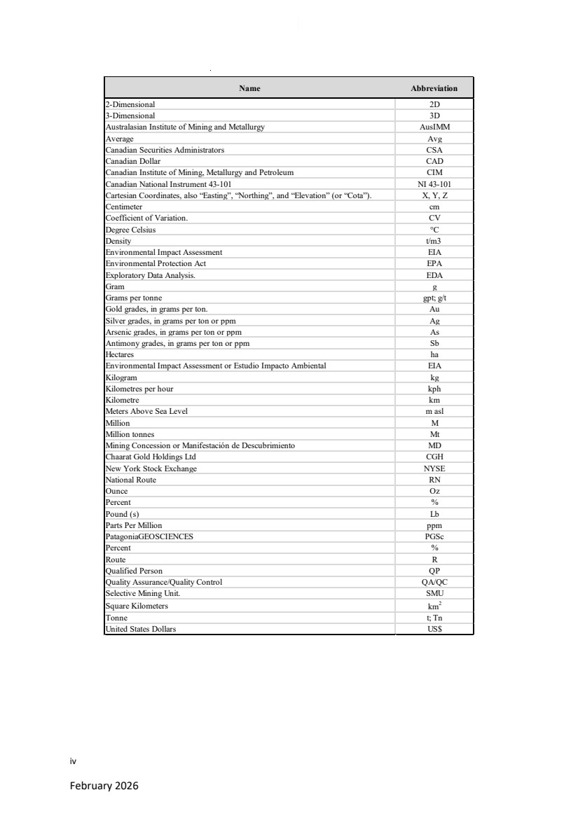
| iii February 2026 ACRONYMS AND ABBREVIATIONS All units of measure in this Report are metric unless otherwise stated. All amounts are in US dollars (US$) unless otherwise stated. A list of abbreviations is provided in the Table below, and a glossary of the mining and other related terms is in Appendix 1. |
| iv February 2026 Name Abbreviation 2-Dimensional 2D 3-Dimensional 3D Australasian Institute of Mining and Metallurgy AusIMM Average Avg Canadian Securities Administrators CSA Canadian Dollar CAD Canadian Institute of Mining, Metallurgy and Petroleum CIM Canadian National Instrument 43-101 NI 43-101 Cartesian Coordinates, also “Easting”, “Northing”, and “Elevation” (or “Cota”). X, Y, Z Centimeter cm Coefficient of Variation. CV Degree Celsius °C Density t/m3 Environmental Impact Assessment EIA Environmental Protection Act EPA Exploratory Data Analysis. EDA Gram g Grams per tonne gpt; g/t Gold grades, in grams per ton. Au Silver grades, in grams per ton or ppm Ag Arsenic grades, in grams per ton or ppm As Antimony grades, in grams per ton or ppm Sb Hectares ha Environmental Impact Assessment or Estudio Impacto Ambiental EIA Kilogram kg Kilometres per hour kph Kilometre km Meters Above Sea Level m asl Million M Million tonnes Mt Mining Concession or Manifestación de Descubrimiento MD Chaarat Gold Holdings Ltd CGH New York Stock Exchange NYSE National Route RN Ounce Oz Percent % Pound (s) Lb Parts Per Million ppm PatagoniaGEOSCIENCES PGSc Percent % Route R Qualified Person QP Quality Assurance/Quality Control QA/QC Selective Mining Unit. SMU Square Kilometers km2 Tonne t; Tn United States Dollars US$ |
| v February 2026 Contents IMPORTANT NOTICE...................................................................................... II ACRONYMS AND ABBREVIATIONS ................................................................ III 1. EXECUTIVE SUMMARY...................................................................... 16 1.1. INTRODUCTION....................................................................................16 1.2. PROPERTY DESCRIPTION, LOCATION AND MINERAL TENURE ............17 1.3. GEOLOGICAL SETTING AND MINERALIZATION....................................18 1.4. EXPLORATION ......................................................................................20 1.5. DATA VERIFICATION.............................................................................21 1.6. MINERAL PROCESSING AND METALLURGICAL TESTING .....................21 1.7. MINERAL RESOURCE ESTIMATES.........................................................22 1.8. INTERPRETATION AND CONCLUSIONS ................................................25 2. INTRODUCTION................................................................................ 27 2.1. TERMS OF REFERENCE .........................................................................27 2.2. QUALIFIED PERSON, SITE VISIT AND AREAS OF RESPONSIBILITY ........28 2.3. INFORMATION SOURCES .....................................................................29 3. RELIANCE ON OTHER EXPERTS .......................................................... 30 4. PROPERTY DESCRIPTION AND LOCATION.......................................... 31 4.1. GENERAL INFORMATION .....................................................................31 4.2. PROPERTY DESCRIPTION AND OWNERSHIP ........................................33 4.3. MINERAL TENURE AND STATUS...........................................................34 4.4. SURFACE LAND USE PERMITS ..............................................................38 4.5. LAND TENURE HISTORY AND AGREEMENTS........................................39 4.6. ROYALTIES............................................................................................40 4.7. ENVIRONMENTAL REGULATIONS ........................................................40 |
| vi February 2026 4.8. WORKS PERMITTING............................................................................41 4.9. CLOSURE CONSIDERATIONS ................................................................42 4.10. SURFACE RIGHTS..................................................................................42 5. ACCESSIBILITY, CLIMATE, LOCAL RESOURCES, INFRASTRUCTURE AND PHYSIOGRAPHY................................................................................ 43 5.1. ACCESSIBILITY ......................................................................................43 5.2. CLIMATE...............................................................................................44 5.3. LOCAL RESOURCES AND INFRASTRUCTURE ........................................45 5.4. PHYSIOGRAPHY....................................................................................45 6. HISTORY........................................................................................... 46 6.1. EXPLORATION HISTORY .......................................................................46 6.2. HISTORICAL MINERAL RESOURCE ESTIMATES.....................................47 7. GEOLOGICAL SETTING AND MINERALIZATION................................... 49 7.1. REGIONAL GEOLOGY............................................................................49 7.2. PROPERTY GEOLOGY............................................................................52 7.3. STRUCTURAL GEOLOGY .......................................................................54 7.4. MINERALIZATION.................................................................................56 8. DEPOSIT TYPES................................................................................. 60 9. EXPLORATION .................................................................................. 63 9.1. GEOPHYSICAL SURVEY .........................................................................64 9.2. GEOCHEMICAL SURVEYES....................................................................64 9.3. EXPLORATION POTENTIAL ...................................................................68 10. DRILLING.......................................................................................... 70 10.1. INTRODUCTION....................................................................................70 10.2. DRILLING METHODS AND PROCEDURES..............................................70 |
| vii February 2026 10.3. COLLAR SURVEYS .................................................................................72 10.4. TOPOGRAPHY.......................................................................................72 10.5. DOWNHOLE SURVEYS..........................................................................73 10.6. SITE SAMPLING, PREPARATION METHODS, AND QUALITY CONTROL FOR DRILL CORE ...................................................................................74 10.7. SAMPLE SECURITY AND CHAIN OF CUSTODY ......................................76 10.8. GEOLOGICAL AND GEOTECHNICAL LOGGING .....................................76 10.9. CORE RECOVERY AND GEOTECHNICAL HOLES ....................................80 10.10. DRILLING RESULTS ...............................................................................82 11. SAMPLE PREPARATION, ANALYSES AND SECURITY............................ 83 11.1. LABORATORY SAMPLE PREPARATION, ASSAYING, AND ANALYTICAL PROCEDURES .......................................................................................84 11.2. STORAGE, SECURITY OF DRILL HOLE DATA, AND SAMPLE DISPATCHING.......................................................................................91 11.3. BULK DENSITY MEASUREMENTS (SPECIFIC GRAVITY).........................91 11.4. QUALITY ASSURANCE-QUALITY CONTROL PROCEDURES....................95 11.5. RESULTS OF CHAARAT GOLD PROJECT, QA/QC ASSESSMENT ............99 11.6. CONCLUSIONS................................................................................... 104 12. DATA VERIFICATION.............................................................................. 106 12.1. SITE VISIT........................................................................................... 106 12.2. QP COMMENTS................................................................................. 116 13. MINERAL PROCESSING AND METALLURGICAL TESTING ...................... 117 13.1. INTRODUCTION................................................................................. 117 13.2. TULKUBASH....................................................................................... 117 13.3. KYZYLTASH ........................................................................................ 118 14. MINERAL RESOURCE ESTIMATES.......................................................... 120 |
| viii February 2026 14.1. INTRODUCTION................................................................................. 120 14.2. KEY ASSUMPTIONS AND BASIS OF ESTIMATE .................................. 120 14.3. WIREFRAME MODEL ......................................................................... 121 14.4. TOPOGRAPHIC DATA ........................................................................ 129 14.5. UNDERGROUND WORKINGS ............................................................ 129 14.6. BULK DENSITY DATA ......................................................................... 130 14.7. EXPLORATORY DATA ANALYSIS (EDA) .............................................. 131 14.8. BLOCK MODEL DEFINITION............................................................... 137 14.9. GRADE ESTIMATION ......................................................................... 137 14.10. GRADE VALIDATION.......................................................................... 142 14.11. RESOURCE CLASSIFICATION.............................................................. 148 14.12. MINERAL RESOURCES ....................................................................... 149 15. MINERAL RESERVE ESTIMATES ............................................................. 155 16. MINING METHODS................................................................................ 156 17. RECOVERY METHODS............................................................................ 157 18. PROJECT INFRASTRUCTURE .................................................................. 158 19. MARKET STUDIES AND CONTRACTS ..................................................... 159 20. ENVIRONMENTAL STUDIES, PERMITTING AND SOCIAL OR COMMUNITY IMPACT.................................................................................................. 160 21. CAPITAL AND OPERATING COSTS ......................................................... 161 22. ECONOMIC ANALYSIS............................................................................ 162 23. ADJACENT PROPERTIES......................................................................... 163 24. OTHER RELEVANT DATA AND INFORMATION ...................................... 164 25. INTERPRETATION AND CONCLUSIONS ................................................. 165 25.1. RISKS AND UNCERTAINTIES .............................................................. 165 |
| ix February 2026 25.2. CONCLUSIONS................................................................................... 167 26. RECOMMENDATIONS ........................................................................... 168 26.1. BUDGET AND PLAN FOR FURTHER WORK ........................................ 168 26.2. RECOMMENDATIONS ....................................................................... 173 27. REFERENCES.......................................................................................... 175 27.1. TECHNICAL REPORTS, PAPERS AND OTHER PUBLICATIONS ............. 175 27.2. WEB-BASED SOURCES OF INFORMATION ........................................ 177 CERTIFICATE OF QUALIFIED PERSON................................................................ 178 CERTIFICATE OF QUALIFIED PERSON................................................................ 179 CERTIFICATE OF QUALIFIED PERSON................................................................ 181 APPENDIX 1 ....................................................................................................... 183 APPENDIX 2 ....................................................................................................... 194 APPENDIX 3 ....................................................................................................... 198 APPENDIX 4....................................................................................................... 200 |
| x February 2026 Figures Figure 1.1: Chaarat Property location.........................................................................17 Figure 4.1: Location of the Chaarat Gold project. ......................................................31 Figure 4.2: View towards the SW of the Tulkubash area; Chaarat Gold Project. Photo from site visit 14/9/2025. ..................................................................33 Figure 4.3: License map of Chaarat Gold Project........................................................35 Figure 5.1: Location of the Chaarat Gold Project and access routes..........................44 Figure 7.1: Chaarat Project Location in Tien Shan Belt...............................................50 Figure 7.2: Chaarat ore field structural control, Sandalash Shear zone.....................51 Figure 7.3: Chaarat ore field, Sandalash Shear zone, geology and mineralization. ...54 Figure 7.4: Scheme of the orogenic gold deposit as a function of depth in the crust (Groves et al., 1998), with modifications. .........................................56 Figure 7.5: Chaarat project mineralization styles, Conceptual cross section.............59 Figure 8.1: Zone of structurally hosted oxidation and alteration within the Tulkubash deposit. ..............................................................................................61 Figure 8.2: MD21M013 – Intensive sulfidation with quartz veining and brecciation of a mineralised intercept hosted in the Kyzyltash Main zone. ............62 Figure 9.1: Chaarat Gold Project, Satellite image, Google Earth 02/2026. ................66 Figure 9.2: Surface trenching across the Chaarat Gold project area..........................67 Figure 9.3: Kyzyltash Contact Zone adit 4, total length approximately 2.1km...........68 Figure 9.4: Location of the Karator and Ishakuldy exploration targets in relation to the main Tulkubash and Kyzyltash deposits......................................69 Figure 10.1: Plan map showing location of drill holes by year for Tulkubash and Kyzyltash deposits..............................................................................71 Figure 10.2: Core logging and data capture................................................................74 Figure 10.3: Core cutting and sample preparation in the core logging facility at the project site.........................................................................................75 |
| xi February 2026 Figure 10.4: Cores are numbered, ordered, and stored in a well maintained, dry and clean core shed..................................................................................78 Figure 10.5: Summary of geological codes implemented for drill core logging.........79 Figure 10.6: Plan view of geotechnical holes listed in Table 10.2 within the Tulkubash area...................................................................................81 Figure 11.2: Sample intake, sorting, and outside storage at Stewart Analytical and Environmental Laboratories. .............................................................89 Figure 11.3: Sample drying at Stewart Analytical and Environmental Laboratories..90 Figure 11.4: Sample crushing, splitting, and milling stations at Stewart Analytical and Environmental Laboratories. .............................................................90 Figure 11.5: Specific gravity measurements of core samples from Kyzyltash in 2021. ...........................................................................................................93 Figure 11.6: Density t/m3 ............................................................................................94 Figure 11.7: Density t/m3 by year. .............................................................................95 Figure 11.8: Box and whisker plot with base statistics for the CRM’s results............97 Figure 11.9: QAQC Program, Coarse Duplicate Results............................................101 Figure 11.10: QAQC Program, Pulp Duplicate Results..............................................102 Figure 11.11: QAQC Program, Field Duplicate Results. ............................................103 Figure 11.12: QAQC Program, Blanks Results...........................................................104 Figure 12.1: Location of drill cores selected for review and check sampling...........108 Figure 12.2: Representation of a mineralized interval selected for detailed review, verification, and check sampling from the Tulkubash deposit........110 Figure 12.3: Close up of the interval selected for review, along with before and after images of the sample which were taken from the core boxes. ......111 Figure 12.4: Photographs of drill hole collars identified and validated in the field .112 Figure 14.1: Planview of ore model 3D, and drill holes used in the current resource estimation........................................................................................121 Figure 14.2: Spatial distribution of mineralized wireframes for Tulkubash and Kyzyltash deposits............................................................................125 |
| xii February 2026 Figure 14.3: Planview of Tulkubash, drill holes used in the current resource estimation, pit silhouette, and ore model sliced at 2500ml. ..........126 Figure 14.4: Planview of Kyzyltash Main Zone, drill holes used in the current resource estimation, ore sliced at 2350ml with +/-100m clipping window. ...........................................................................................127 Figure 14.5: Kyzyltash Contact Zone, drill holes used in the current resource estimation, looking down dip through Kyz_15................................128 Figure 14.6: Contact Zone adit 4, total length of approximately 2.1 km.........130 Figure 14.7: Histogram and frequency plot basic statistics (Au ppm)......................132 Figure 14.8: Histogram and frequency plot basic statistics (Ag ppm)......................133 Figure 14.9: Histogram and frequency plot basic statistics (As ppm). .....................133 Figure 14.10: Histogram and frequency plot basic statistics (Sb ppm). ...................134 Figure 14.11: Histogram showing majority of samples of 1.5 m length...................135 Figure 14.12: Decile analysis showing the top cut statistics for Au..........................136 Figure 14.13: Decile analysis showing the top cut statistics for Ag..........................136 Figure 14.14: Tulkubash mineralization trend. A) Tulkubash Main pit area with 3D ore wireframes and drillholes, B) Trend surfaces created explicitly following main trends, C) Structural trend file created based on these trend surfaces with 50m grid cell size. ..................................138 Figure 14.15: Kyzyltash mineralization trend. A) Kyzyltash main zone and contact zone with 3D ore wireframes and drillholes, B) Trend surfaces created explicitly following main trends, C) Structural trend file created based on these trend surfaces with 80m grid cell size. .....138 Figure 14.16: Tulkubash, Au, Main Pit Area (clipping ±20m) Level Plan 2500ml Elevation. .........................................................................................143 Figure 14.17: Tulkubash, Au, Main Pit Area (clipping ±15m) long section...............144 Figure 14.18: Kyzyltash, Au, Main Zone (clipping ±20m) level plan 2470ml. ...........145 Figure 14.19: Kyzyltash, Au, contact zone (clipping ±20m) section NE-SW. ............146 Figure 14.20: Swath plot, assay composites.............................................................147 Figure 14.21: Tulkubash Pit shells.............................................................................149 |
| xiii February 2026 Figures 23.1: Chaarat Project Location in Tien Shan Belt and Mine map................163 Figure 26.1 Plan view of planned underground Tunnel for Contact Zone Extension .........................................................................................................169 Figure 26.2 Rotated view of planned underground Tunnel for Contact Zone Extension..........................................................................................170 Figure 26.3 SVM planned drillholes..........................................................................171 Figure 26.4 Planned drillholes from underground tunnels, Contact Zone extension. .........................................................................................................172 |
| xiv February 2026 Tables Table 1.1: Chaarat block model definition.................................................................. 23 Table 1.2: Tulkubash Pit Constrained Mineral Resource Estimate........................... 24 Table 1.3: Kyzyltash Mineral Resource Estimate........................................................ 25 Table 4.1: Chaarat Mining and Exploration License coordinates. .............................. 36 Table 4.2: Mining License agreement No. 4. .............................................................. 39 Table 6.1: Historic drilling statistics for Au assay results (g/t) at Tulkubash. ............. 47 Table 6.2: Historic drilling statistics for Au assay results (g/t) at Kyzyltash. .............. 47 Table 10.1: Drilling metres by year for Tulkubash and Kyzyltash............................... 71 Table 10.2: Summary list of geotechnical holes drilled in the Tulkubash area. ......... 80 Table 11.1: Laboratories used by Chaarat ZAAV. ....................................................... 84 Table 11.2: Distribution of control samples per year as a percentage of total samples. ............................................................................................. 96 Table 12.1: Summary of check samples taken from Tulkubash, Kyzyltash, and Karator deposits............................................................................................ 109 Table 12.2: Summary of comparison between Chaarat (digital) and Silvercorp (field) co-ordinates for select drill holes. ................................................... 113 Table 12.3: Digital data verification, drilling campaign 2018. .................................. 114 Table 12.4: Digital data verification, drilling campaign 2019 ................................... 115 Table 12.5: Digital data verification, drilling campaign 2020. .................................. 115 Table 12.6: Digital data verification, drilling campaign 2021. .................................. 116 Table 13.1: Gold recovery following various recovery methods of test samples from Kyzyltash main and contact zones (SGS, 2022). .............................. 119 |
| xv February 2026 Table 14.1: Summary of drilling used in the current resource estimate by year..... 120 Table 14.2: List of all ore wireframes in Tulkubash .................................................. 123 Table 14.3: List of all ore wireframes in Kyzyltash.................................................... 124 Table 14.4: Summary bulk density statistics............................................................. 131 Table 14.5: Density estimation parameters. ............................................................ 131 Table 14.6: Chaarat block model definition.............................................................. 137 Table 14.7: Additional Ellipsoids Parameters. .......................................................... 139 Table 14.8: Parameters used for Grade Interpolations............................................ 141 Table 14.9: Assumptions for Tulkubash Mineral Resource Estimate. ...................... 149 Table 14.10: Tulkubash Mineral Resource Statement.............................................. 152 Table 14.11: Kyzyltash Mineral Resource Statement. .............................................. 153 Table 26.1: Budget for the Exploration of the Chaarat Property ............................. 173 |
| Page 16 February 2026 Chaarat Gold Project Chatkal district, Kyrgyzstan NI 43-101 Technical Report Mineral Resource Update 1. EXECUTIVE SUMMARY 1.1.INTRODUCTION This report has been prepared by Silvercorp Metals Inc., in accordance with the disclosure requirements of National Instrument 43-101 Standards of Disclosure for Mineral Projects (NI 43-101). The main purpose of this report is to report on the updated Mineral Resource for the Chaarat gold project. Per the agreements between the parties, Silvercorp will proceed to convert Chaarat ZAAV CJSC (“Chaarat ZAAV”) into a joint venture company (“JVC”) with Kyrgyzaltyn (a wholly-owned subsidiary of the Kyrgyz Republic), with Silvercorp holding a 70% interest and being the operator of the JVC and Kyrgyzaltyn holding a 30% free-carried interest. This report and Mineral Resource Estimate has been prepared by Silvercorp’s Technical Services department consisting of Ms. Lei Xue, B.Sc., P.Geo. and Dr. Donovan Pienaar, Ph.D., M.Sc., MBA, under the guidance of Guoliang Ma (P.Geo), Manager of Exploration and Resource at Silvercorp, and Alex Zhang (P.Geo), consultant to Silvercorp. The effective date of this report is 15th October 2025. This Mineral resource estimate update included remodeling of the Tulkubash and Kyzltash ore wireframes, geostatistical analysis and grade interpolation incorporating all the technical data prepared by the Silvercorp technical team. Silvercorp is a Canadian mining company producing silver, gold, lead, and zinc with a long history of profitability and growth potential. The Company’s strategy is to create shareholder value by 1) focusing on generating free cash flow from stable operations with a long life of mine; 2) organic growth through extensive drilling for discovery; 3) ongoing mergers and acquisition efforts to unlock value; and 4) long term commitment to responsible mining and ESG. For more information, please visit our website at www.silvercorpmetals.com. Mineral resource estimates were prepared following with the Canadian Institute of Mining, Metallurgy and Petroleum (CIM) Estimation of Mineral Resources and Mineral Reserves Best Practice Guidelines (CIM, 2019) and reported in accordance with the CIM Definition Standards for Mineral Resources and Mineral Reserves (CIM Definition Standards, 2014). All units of measure in this Report are metric unless otherwise stated. All amounts are in US dollars (US$) unless otherwise stated. |
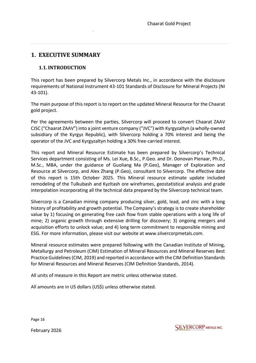
| Page 17 February 2026 Chaarat Gold Project Chatkal district, Kyrgyzstan NI 43-101 Technical Report Mineral Resource Update 1.2. PROPERTY DESCRIPTION, LOCATION AND MINERAL TENURE The Chaarat Project is located on the southeastern portion of the Sandalash mountain range, along the northwestern margin of the Sandalash River, in the Chatkal district, Jalal-Abad Oblast of western Kyrgyzstan, approximately 300 km southwest of the capital of Bishkek. Figure 1.1: Chaarat Property location The project has an area of 3,443 hectares composed of one mining license (#3117AE) of 700 hectares valid until 2032 and one exploration license (#3319AP) of 2,743 hectares valid until September 2026. The project has been explored with a combination of surface core drilling, underground core drilling, chip and channel samples from road cuts, trench sampling across the strike of |
| Page 18 February 2026 Chaarat Gold Project Chatkal district, Kyrgyzstan NI 43-101 Technical Report Mineral Resource Update structural zones at surface, and continuous chip channel sampling along mineralised exposures of underground workings. Prior work by other consultants have provided more detailed reviews of sampling, assaying, and laboratory QA/QC practices. The reader is referred to a number of previous Resource Estimate and technical reports prepared for the Chaarat project, with particular emphasis on the published reports by SRK Consulting (South Africa), 2009, Wardell Armstrong International (UK), 2012, “Chaarat Project Resource Update”, effective date of report: March 2012; GeoSystems International Inc. “Chaarat Gold Project, Republic of Kyrgyzstan, effective date report: 19 October 2014” and “Mineral Resource update Tulkubash zone, Chaarat Gold Project, Republic of Kyrgyzstan, effective date of report: 5 February, 2017”; Tetra Tech (UK), 2018, “Bankable Feasibility Study for the Tulkubash Gold Project, Kyrgyz Republic”, effective date of report: 25 April 2018; Logiproc (South Africa), 2019, “Tulkubash Gold Project Bankable Feasibility Study Update Report”, effective date: August 2019; Logiproc (South Africa), 2021, “Tulkubash Gold Project Bankable Feasibility Study Update Report”, effective date: May 2021. The classification of Mineral Resources in earlier reports was conducted in accordance with the JORC Code and its associated guidelines. Subsequent reports after those dates were also reviewed, with particular attention given to internal documents developed by Chaarat Gold Holdings Ltd. By Mr. Dimitar Lazarov Dimitrov MAIG, “Kyzyltash Gold Project Mineral Resource update, date: October 15th, 2024” and “Tulkubash Gold Project Mineral Resource Estimate, date: April 2022”. Members of Silvercorp’s technical services team conducted a site visit to the sample preparation and assay laboratory (SAEL laboratories) in Kara Balta, which is utilized for analytical purposes related to the project. Based on direct observations and the findings of prior consultants, the QPs consider the sample database to be meeting the best industry standards and correctly represented in this report, and to be of sufficient quality to support Mineral Resource estimation for the Tulkubash and Kyzyltash deposits. 1.3.GEOLOGICAL SETTING AND MINERALIZATION The Chaarat Property is situated in a vast Geological Belt located within the extensive Tien Shan Metallogenic Belt, a geological formation stretching over 2,500 kilometers that was created during the Hercynian mountain-building period. This belt is a classic example of a fold and thrust belt, formed by the collision of tectonic plates. The Tien Shan belt is comprised of three main tectono-stratigraphic units, which are separated by significant structural zones. These units are interpreted as accretionary prisms that developed at the edge of the ancient Eurasian continent. |
| Page 19 February 2026 Chaarat Gold Project Chatkal district, Kyrgyzstan NI 43-101 Technical Report Mineral Resource Update The property itself lies within the Middle Tien Shan province, which is made up of tectonic fragments of rocks dating from the Ordovician to Carboniferous periods. The Middle Tien Shan extends in a roughly east-west direction, with a width ranging from 20 to 100 kilometers to the south of the Northern Tien Shan. A major geological feature, the Talas-Fergana transverse fault, divides this province into two distinct parts: the Naryn sector to the east and the Chatkal sector to the west. The northern boundary of the Middle Tien Shan is defined by the Nikolayev’s fault (also referred to as Nikolayev's line), while its southern boundary is marked by the Atbashy-Inylchek fault in the Naryn sector and the Kara-Suu fault in the Chatkal sector. Structurally, the eastern and western sectors of the Middle Tien Shan show notable differences. In the Naryn sector, the folded geological structures predominantly have an east-west orientation. In contrast, the folded structures in the Chatkal region exhibit a north-east strike that gradually changes to a south-east strike as they approach the Talas-Fergana fault. The metallogeny of the Middle Tien Shan is rich and varied, hosting several major mineral deposits. This includes significant gold deposits such as Kumtor and Makmal. The region is also endowed with molybdenum, found at deposits like Molo and Chaartash, and tungsten at locations including Kensu and Kumbel. Furthermore, there are substantial iron deposits at Gava and Jetym, as well as uranium, molybdenum, and vanadium at Saryjaz. The area's mineral wealth is further exemplified by copper deposits at Kuru-Tegerek and Bozymchak, polymetallic deposits at Sumsar, and antimony at Terek and Kassan. The geology of the Chaarat Gold Project, which includes the Tulkubash and Kyzyltash areas, is situated within the Tien Shan Metallogenic Belt, an extensive fold and thrust belt that traverses Central Asia. Both mineralization zones are classified as orogenic gold deposits, formed during the deformation of metamorphic belts, yet they exhibit distinct characteristics that reflect different formation conditions. There are clear visual clues to detect the more mineralized shear zones, such as quartz-carbonate veining, shearing, and veining; these will be helpful for grade control in an operating mine; however, while these clues are easily observed in the field, they are more difficult to distinguish in the core boxes, due to core crumbling, particularly if mineralized. In summary, the geology of the Chaarat project reveals a large-scale, structurally controlled orogenic gold system. Kyzyltash represents a deeper, high-grade, and moderately-refractory sulphide rich style of mineralization, while Tulkubash represents an oxidised, shallower, lower-grade, more extensive manifestation with easily extractable gold, thus showcasing the diversity of mineralization styles within the same regional geological system. |
| Page 20 February 2026 Chaarat Gold Project Chatkal district, Kyrgyzstan NI 43-101 Technical Report Mineral Resource Update In the opinion of the QP, the knowledge of the deposit setting, lithology, structural and alteration controls, and mineralization style is sufficiently well understood to support the current Mineral Resource estimate at this stage of the property’s development. 1.4. EXPLORATION An in-depth exploration program at the Chaarat Gold Project has been undertaken to expand the existing NI 43-101 resource by testing the potential for new gold zones. This program has included a variety of methods such as geological mapping, geophysics, surface rock sampling, core drilling, preliminary metallurgical test work, and mineral resource estimation. The drilling efforts, for the most part, have been concentrated on previously untested areas and potential strike extensions of known gold-hosting structural trends. Additionally, the program has investigated outlying targets not currently part of the resource, where trenching has revealed gold anomalies supported by geophysical data. The exploration activities have successfully defined the Tulkubash and Kyzyltash mineralization as trending southwest-northeast with a sub-vertical to -60° dip. Despite challenges posed by topography and avalanches that prevent drilling in certain areas, the remarkable strike continuity of the mineralized zones suggests they are connected. However, without drilling, no resource can be officially delineated in these gaps. The quality of the data gathered is considered high, meeting industry standards for resource estimation and mine planning. There is strong potential for resource expansion, particularly to the northeast and within the undrilled gaps along the strike, which will likely require underground access. Silvercorp reviewed the exploration work conducted by the previous project owner (Chaarat Gold Holdings Limited (CGH)) and believe that the Project warrants further exploration to validate and expand on the existing mineralization, and to identify other mineralized zones on the property. Additional drilling targets will be defined in the future to increase the confidence of the known resource, as well as to add additional resources through brown fields exploration. In the opinion of the QP, the exploration programs completed to date are appropriate for the deposit and prospect styles present within the Project. The strike extent of currently known veins is likely to be extended with additional drilling in areas of challenging topography and beneath post-mineral cover. |
| Page 21 February 2026 Chaarat Gold Project Chatkal district, Kyrgyzstan NI 43-101 Technical Report Mineral Resource Update 1.5. DATA VERIFICATION The scope of the site inspection was to discuss and analyze general data acquisition and sampling procedures, quality assurance and quality control (QA/QC) procedures, geology, mineralization, structural characteristics, mineral processing and metallurgical testing, mineral resource estimation, drill pads, core storage, drill core recovery, as well as infrastructure and permits granted to the project owner. SVM collected samples for independent check assays and verification from 13 drill holes, which covered the Tulkubash oxide deposit (3 drill holes, 4 samples), Kyzyltash main zone (4 drill holes, 5 samples), Kyzyltash contact zone (5 drill holes, 8 samples), and the Karator oxide exploration target (1 drill holes, 2 samples). The check assays did not show any systematic bias from the original assay results. Furthermore, all drilling phases were reported in news releases and internal reports by the previous project owner and published on the company's website. These reports are considered to be sufficient by the QP as evidence of the presence of economic grades of mineralization. The site visit to the Chaarat Gold Project to complete the NI 43-101 requirements was conducted from 11 September to 17 September 2025, by Alex Zhang (P. Geo) and Dr. Donovan Pienaar. Based on the data verification performed, the QP is of the opinion that the collar coordinates, downhole surveys, lithologies, mineralization, and assay results comply with industry standards and are adequate for Mineral Resource estimation. 1.6. MINERAL PROCESSING AND METALLURGICAL TESTING Recent mineralogical and metallurgical studies by SGS Lakefield on the Kyzyltash ore confirmed that the mineralization is dominated by quartz and muscovite, with minor potassium-feldspars and ankerite/dolomite. Sulphide mineralization consists primarily of arsenopyrite and pyrite, which host most of the gold. The gold is predominantly fine-grained, with 60% to 80% being less than 10 μm, and is classified as sulphide-rich, unoxidized refractory material occurring within the arsenopyrite and pyrite. Consequently, for the gold to be accessible for cyanide extraction, the sulphide host matrix must first be decomposed, typically through a chemical or biological pre-oxidation of a sulphide flotation concentrate. Silver also occurs in solid solution within antimony sulphides such as stibnite and boulangerite. A detailed metallurgical study is currently underway to define the most suitable processing route for the refractory ore at Kyzyltash, which is planned to be developed through both open pit and underground mining. Metallurgical test work was conducted on 78 metallurgical composites comprising 991 individual samples. It was found that total sulphur content influenced the metallurgical |
| Page 22 February 2026 Chaarat Gold Project Chatkal district, Kyrgyzstan NI 43-101 Technical Report Mineral Resource Update recoveries of gold in a meaningful way, with high sulphur samples (un-oxidised) yielding lower recoveries than oxidised samples, which yielded higher gold recoveries. In 2021, approximately 3,500 meters of metallurgical drilling were completed at Kyzyltash, including the twinning of historical holes. The most recent drilling and metallurgical data was used to further inform the 2024 wireframe update. A bulk sample for metallurgical testing at Kyzyltash was obtained from an underground exploration adit developed in 2006. Silvercorp and the QP are in full agreement with conclusions drawn from previous test work. Silvercorp recognises that two stages of mining and processing are required for the Chaarat gold project, with the first phase entailing the development, mining, and processing of the Tulkubash oxide ore, which can be processed through heap leaching, and a second stage that would include the sulphide-rich ore of the Kyzyltash deposit. Processing of the Kyzyltash ores would likely require alternative processing methods involving flotation- BIOX on floatation concentrate-CIL, returning overall gold recoveries of 88.2% for the Contact Zone ore, and 82.2% for the Main Zone ore as indicated by previous test work on samples from Kyzyltash. Similar processing could be tested for the increasingly sulphide rich ore located at depth at Tulkubash in future metallurgical programs. 1.7. MINERAL RESOURCE ESTIMATES Guoliang Ma, P.Geo., reviewed and validated the resource model prepared for this technical report. It is the opinion of the QP that the reported Mineral Resource is a reasonable representation of the available and up to date technical data and represents a solid base for further Feasibility Study and Ore Reserve estimates. For this resource update, the Tulkubash deposit estimate is supported by 711 drillholes totalling 100,791 meters, while the Kyzyltash deposit estimate is based on 384 drillholes totalling 78,735 meters. Not all historical and new holes were used in the update of the Mineral Resource Estimate since the database includes holes outside of the current geological models delivered by the geology team, which are the basis of this Mineral Resource Estimate. The mineralization interpretation was done without reference to any historical models. The interpretation prioritized the continuity of mineralization trends and structural alignment, emphasizing zones of consistent grade rather than isolated high-grade intercepts. |
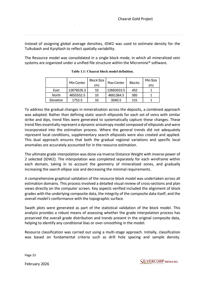
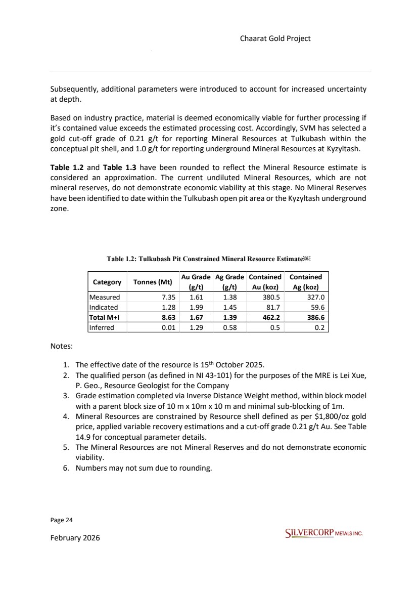
| Page 23 February 2026 Chaarat Gold Project Chatkal district, Kyrgyzstan NI 43-101 Technical Report Mineral Resource Update Instead of assigning global average densities, IDW2 was used to estimate density for the Tulkubash and Kyzyltash to reflect spatially variability. The Resource model was consolidated in a single block mode, in which all mineralized vein systems are organized under a unified file structure within the Micromine® software. Table 1.1: Chaarat block model definition. To address the gradual changes in mineralization across the deposits, a combined approach was adopted. Rather than defining static search ellipsoids for each set of veins with similar strike and dips, trend files were generated to systematically capture these changes. These trend files essentially represent a dynamic anisotropy model composed of ellipsoids and were incorporated into the estimation process. Where the general trends did not adequately represent local conditions, supplementary search ellipsoids were also created and applied. This dual approach ensures that both the gradual regional variations and specific local anomalies are accurately accounted for in the resource estimation. The ultimate grade interpolation was done via Inverse Distance Weight with inverse power of 2 selected (IDW2). The interpolation was completed separately for each wireframe within each domain, taking in to account the geometry of mineralized zones, and gradually increasing the search ellipse size and decreasing the minimal requirements. A comprehensive graphical validation of the resource block model was undertaken across all estimation domains. This process involved a detailed visual review of cross-sections and plan views directly on the computer screen. Key aspects verified included the alignment of block grades with the underlying composite data, the integrity of the composite data itself, and the overall model's conformance with the topographic surface. Swath plots were generated as part of the statistical validation of the block model. This analysis provides a robust means of assessing whether the grade interpolation process has preserved the overall grade distribution and trends present in the original composite data, helping to identify any conditional bias or over-smoothing in the model. Resource classification was carried out using a multi-stage approach. Initially, classification was based on fundamental criteria such as drill hole spacing and sample density. Min Center Block Size (m) Max Center Blocks Min Size (m) East 12678535.5 10 12683033.5 452 1 North 4655552.5 10 4661384.5 585 1 Elevation 1753.5 10 3040.5 131 1 |
| Page 24 February 2026 Chaarat Gold Project Chatkal district, Kyrgyzstan NI 43-101 Technical Report Mineral Resource Update Subsequently, additional parameters were introduced to account for increased uncertainty at depth. Based on industry practice, material is deemed economically viable for further processing if it’s contained value exceeds the estimated processing cost. Accordingly, SVM has selected a gold cut-off grade of 0.21 g/t for reporting Mineral Resources at Tulkubash within the conceptual pit shell, and 1.0 g/t for reporting underground Mineral Resources at Kyzyltash. Table 1.2 and Table 1.3 have been rounded to reflect the Mineral Resource estimate is considered an approximation. The current undiluted Mineral Resources, which are not mineral reserves, do not demonstrate economic viability at this stage. No Mineral Reserves have been identified to date within the Tulkubash open pit area or the Kyzyltash underground zone. Table 1.2: Tulkubash Pit Constrained Mineral Resource Estimate Notes: 1. The effective date of the resource is 15th October 2025. 2. The qualified person (as defined in NI 43-101) for the purposes of the MRE is Lei Xue, P. Geo., Resource Geologist for the Company 3. Grade estimation completed via Inverse Distance Weight method, within block model with a parent block size of 10 m x 10m x 10 m and minimal sub-blocking of 1m. 4. Mineral Resources are constrained by Resource shell defined as per $1,800/oz gold price, applied variable recovery estimations and a cut-off grade 0.21 g/t Au. See Table 14.9 for conceptual parameter details. 5. The Mineral Resources are not Mineral Reserves and do not demonstrate economic viability. 6. Numbers may not sum due to rounding. Category Tonnes (Mt) Au Grade (g/t) Ag Grade (g/t) Contained Au (koz) Contained Ag (koz) Measured 7.35 1.61 1.38 380.5 327.0 Indicated 1.28 1.99 1.45 81.7 59.6 Total M+I 8.63 1.67 1.39 462.2 386.6 Inferred 0.01 1.29 0.58 0.5 0.2 |
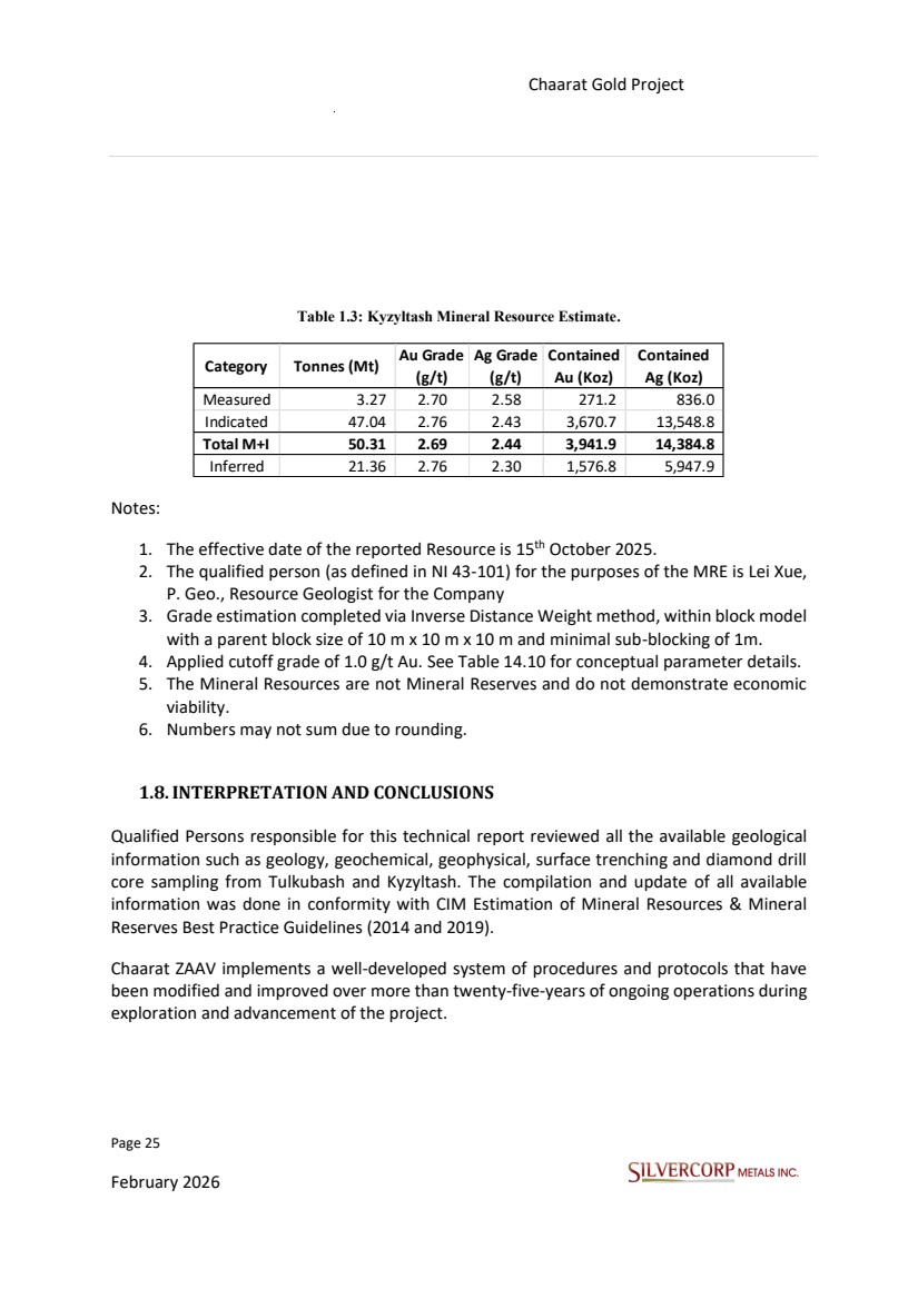
| Page 25 February 2026 Chaarat Gold Project Chatkal district, Kyrgyzstan NI 43-101 Technical Report Mineral Resource Update Table 1.3: Kyzyltash Mineral Resource Estimate. Notes: 1. The effective date of the reported Resource is 15th October 2025. 2. The qualified person (as defined in NI 43-101) for the purposes of the MRE is Lei Xue, P. Geo., Resource Geologist for the Company 3. Grade estimation completed via Inverse Distance Weight method, within block model with a parent block size of 10 m x 10 m x 10 m and minimal sub-blocking of 1m. 4. Applied cutoff grade of 1.0 g/t Au. See Table 14.10 for conceptual parameter details. 5. The Mineral Resources are not Mineral Reserves and do not demonstrate economic viability. 6. Numbers may not sum due to rounding. 1.8.INTERPRETATION AND CONCLUSIONS Qualified Persons responsible for this technical report reviewed all the available geological information such as geology, geochemical, geophysical, surface trenching and diamond drill core sampling from Tulkubash and Kyzyltash. The compilation and update of all available information was done in conformity with CIM Estimation of Mineral Resources & Mineral Reserves Best Practice Guidelines (2014 and 2019). Chaarat ZAAV implements a well-developed system of procedures and protocols that have been modified and improved over more than twenty-five-years of ongoing operations during exploration and advancement of the project. Category Tonnes (Mt) Au Grade (g/t) Ag Grade (g/t) Contained Au (Koz) Contained Ag (Koz) Measured 3.27 2.70 2.58 271.2 836.0 Indicated 47.04 2.76 2.43 3,670.7 13,548.8 Total M+I 50.31 2.69 2.44 3,941.9 14,384.8 Inferred 21.36 2.76 2.30 1,576.8 5,947.9 |
| Page 26 February 2026 Chaarat Gold Project Chatkal district, Kyrgyzstan NI 43-101 Technical Report Mineral Resource Update In the opinion of the responsible QP, the following interpretations and conclusions are appropriate to the project's status: • Information from legal experts supports that the mining tenure held is valid and sufficient to support a declaration of Mineral Resources. • There is no awareness of any significant environmental, social or permitting issues that would prevent continued exploitation of the project deposits. • Knowledge of the deposit settings and lithologies, as well as the structural and alteration controls on mineralization and the mineralization style and setting, is sufficient to support Mineral Resource estimation. • The exploration programs completed to date are appropriate for the style of the deposits and prospects within the project. The strike extent of presently-known veins are likely to be extended with additional drilling in areas of subdued topography and under post-mineral cover. Numerous instances of quartz veins and silicified rock with anomalous gold values remain to be thoroughly evaluated. • The quantity and quality of the lithological, geotechnical, collar and down-hole survey data collected during the exploration and delineation drilling programs are sufficient to support gold and silver Mineral Resource Estimate. The collected sample data adequately reflect the deposit dimensions, true widths of mineralization, and the style of mineralisation for the deposits. Sampling is representative of the metal grades in the deposit, reflecting areas of higher and lower grades. • The QA/QC procedures adequately address precision, accuracy and cross-contamination issues. Drilling programs typically included blanks, duplicates and CRM samples. QA/QC submission rates meet industry-accepted standards. The QA/QC programs did not detect any material sample biases. • Factors that may affect the Mineral Resource estimates include metal prices and assumptions related to shell constraining for Open Pit Mineral Resources including mining, dilution, processing and G&A costs, metal recoveries, and pit slope angle. |
| Page 27 February 2026 Chaarat Gold Project Chatkal district, Kyrgyzstan NI 43-101 Technical Report Mineral Resource Update 2. INTRODUCTION 2.1.TERMS OF REFERENCE Silvercorp (SVM), through its Kyrgyz subsidiary, Chaarat ZAAV CJSC (Chaarat ZAAV), is developing the Tulkubash and Kyzyltash gold deposits(collectively known asthe Chaarat Gold Project) located in the western part of the Kyrgyz Republic. Silvercorp Metals Inc., through its subsidiary Chaarat ZAAV, jointly owns the Tulkubash and Kyzyltash gold projects through a joint venture company (JVC) formed between Chaarat ZAAV, and Kyrgyzaltyn (a wholly owned subsidiary of the Kyrgyz Republic) in which Silvercorp holds a 70% interest and will be the operator of the JVC and Kyrgyzaltyn holds a 30% free-carried interest. This Mineral Resource Estimate has been prepared by Silvercorp’s geological department, under the guidance of Guoliang Ma (P.Geo), Manager of Exploration and Resource of Silvercorp, and Alex Zhang (P.Geo), consultant to Silvercorp. The effective date of this report is 15th October 2025 under National Instrument 43-101 Standards of Disclosure for Mineral Projects (NI 43-101). This Mineral resource update included remodelling and updating of the Tulkubash and Kyzyltash ore wireframes, geostatistical analysis, and all the technical data prepared by the technical team. This report has been prepared in accordance with NI43-101. In addition, the Standards and Guidelines of the Canadian Institute of Mines and Metallurgy (CIMM) have been followed in the development of this mineral resource estimate. The information in this Report was derived from published material, geological data, professional opinions, and unpublished material submitted by the professional staff of Silvercorp or its consultants, and the Qualified Persons (QP) observations and analysis. Much of the data are derived from prior reports on the Chaarat Gold Project, updated information provided by Chaarat ZAAV, and information researched by the QP. This Report includes technical information which requires subsequent calculations or estimates to derive sub-totals, totals, and weighted averages. Such calculations or estimations inherently involve a degree of rounding and consequently introduce a margin of error. Where these occur, the QP did not consider them material. This Report is intended to be used by Silvercorp. The author reserves the right, but will not be obliged, to revise this Report and conclusions if additional information becomes known to them after the date of this Report. Using this report acknowledges acceptance of the foregoing conditions. |
| Page 28 February 2026 Chaarat Gold Project Chatkal district, Kyrgyzstan NI 43-101 Technical Report Mineral Resource Update 2.2.QUALIFIED PERSON, SITE VISIT AND AREAS OF RESPONSIBILITY Members of Silvercorp’ s technical team who conducted field and site visits to the Chaarat gold project, and co-authored this technical report include Alex Zhang (P.Geo), consultant for Silvercorp, and Dr. Donovan Pienaar, Geologist - Business Development for Silvercorp. Additional co-authors of this technical report and principle QP’s responsible for data verification, validation, and compilation of the mineral resource estimate for the Tulkubash and Kyzyltash deposits include Guoliang Ma (P.Geo), Manager of Resources and Exploration for Silvercorp, and Lei Xue (P.Geo), Senior Resource geologist for Silvercorp. The QPs and other professionals responsible for the compilation, summary, and review of data, and the preparation of this Technical Report have extensive experience in the mining industry and possess the appropriate professional qualifications: • Lei Xue, P. Geo, B.Sc. (Geology), has over 15 years of experience as a geologist working in mineral exploration and mine geology including mainly gold, silver, and copper deposits in Latin America, North America, Africa, Asia, and Australia. Lei Xue is responsible for the preparation of Section 14 of the Technical Report. • Alex Zhang, M. Eng., M.Sci., P. Geo, has over 35 of years of industry experience as a mineral exploration geologist assuming managerial positions with exploration and mining companies of base and precious metals. Mr. Zhang is responsible for all sections of the technical report except Section 14 which is prepared by Ms. Lei Xue, P.Geo. • Guoliang Ma, P.Geo, M.Sci., has over 30 years of experience in the preparation of Resource and Reserve statements, due diligence reviews, and mining and exploration property valuations across a broad range of metalliferous mining projects. Mr. Ma takes the general responsible role in the technical report. • Dr. Donovan Pienaar, Ph.D, M.Sc. (Geology), MBA, has over 16 years of experience as a geologist, having worked in senior leadership roles as a mine, corporate, and exploration geologist with a primary focus on gold. Dr. Pienaar also has extensive experience related to the technical and financial assessment of mineral projects across multiple jurisdictions in Africa, South America, central and southern Asia, and Oceana, with a particular focus on precious and base metal deposits of various kinds. Dr. Pienaar served as a contributing author to all sections except Section 14, as well as assisting with data verification related to check sampling and field verification of drill hole collars and geological data as outlined in Section 12. |
| Page 29 February 2026 Chaarat Gold Project Chatkal district, Kyrgyzstan NI 43-101 Technical Report Mineral Resource Update The site visit to the Tulkubash and Kyzyltash projects, the corporate office in Bishkek, the core storage facility, as well as Stewart Analytical and Environmental Laboratories (SAEL) where sample analysis for the project is done, was conducted from 11 September to 17 September 2025, by members of Silvercorp’s geology and technical services team, Alex Zhang (P.Geo), and Dr. Donovan Pienaar. The purpose of the site visit was to discuss, analyze, and validate general data acquisition procedures, sampling procedures, quality assurance/quality control (QA/QC) procedures, geology, mineralization, structural characteristics, mineral processing and metallurgical testing, mineral resources estimating, drill pad and drill collar locations, core storage, an inspection of drill core recovery and mineralization, as well as infrastructure and permits collected by the previous project owner. 2.3.INFORMATION SOURCES The material in this Report was derived from published material, data, professional opinions and unpublished material submitted by the professional staff of the previous project owners (Chaarat Gold Holdings) or its consultants. Much of this data came from material prepared and provided by Chaarat ZAAV. The sources of the information in this report are listed in Section 27.0. The geology, mineralization, and exploration descriptions used in this Report are taken from reports prepared by various organizations and companies or their contracted consultants, and from various government and academic publications. The conclusions of this Report are based partly on published data available, and on unpublished reports supplied by the companies which have conducted exploration on the property, as well as information supplied by Chaarat ZAAV and the previous project owners. Silvercorp and the QP have no reason to doubt its validity and have used the information where it has been verified through their review and discussions. Some figures and tables contained within this Report were reproduced or derived from historical reports written on the property by various individuals and supplied to Silvercorp for this Report. |
| Page 30 February 2026 Chaarat Gold Project Chatkal district, Kyrgyzstan NI 43-101 Technical Report Mineral Resource Update 3. RELIANCE ON OTHER EXPERTS This report was prepared in accordance with NI 43-101. All the workflow and conclusions reported herein were prepared by Silvercorp’s Technical Services department supervised by Gouliang Ma (P. Geo), Manager of Exploration and Resource of Silvercorp, and Alex Zhang (P. Geo) consultant to Silvercorp. The information, conclusions, opinions, and estimates contained herein are based on the following: • Information available at the time of preparation of this Technical Report. • Assumptions, conditions, and qualifications as outlined in this Technical Report. |
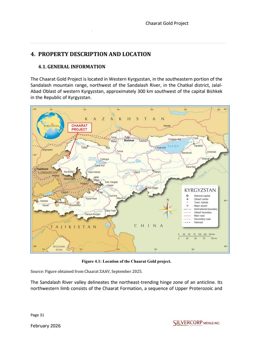
| Page 31 February 2026 Chaarat Gold Project Chatkal district, Kyrgyzstan NI 43-101 Technical Report Mineral Resource Update 4. PROPERTY DESCRIPTION AND LOCATION 4.1.GENERAL INFORMATION The Chaarat Gold Project is located in Western Kyrgyzstan, in the southeastern portion of the Sandalash mountain range, northwest of the Sandalash River, in the Chatkal district, Jalal-Abad Oblast of western Kyrgyzstan, approximately 300 km southwest of the capital Bishkek in the Republic of Kyrgyzstan. Figure 4.1: Location of the Chaarat Gold project. Source: Figure obtained from Chaarat ZAAV, September 2025. The Sandalash River valley delineates the northeast-trending hinge zone of an anticline. Its northwestern limb consists of the Chaarat Formation, a sequence of Upper Proterozoic and |
| Page 32 February 2026 Chaarat Gold Project Chatkal district, Kyrgyzstan NI 43-101 Technical Report Mineral Resource Update Cambrian-Ordovician siliciclastic rocks that dip at approximately 50° to the northwest. The Formation comprises greywacke, sandstone with interbedded siltstone and shale, alternating layers of siltstone and black shale containing limestone lenses and is capped by a tillite. Mineralization at the Chaarat deposit is described as orogenic in nature characterized by an elemental suite of gold (Au), silver (Ag), antimony (Sb), and arsenic (As). The depth of mineralization is estimated to have been more than 1,000 meters at the time of its formation, based on stratigraphic reconstruction. The deposition of minerals was primarily driven by chemical reactions between hydrothermal solutions and the wall rocks, contrasting with the physical processes such as cooling and boiling that are predominant in shallow epithermal systems. The relative importance of these solution-driven reactions is evidenced by pervasive sericitization, the presence of very fine-grained disseminated sulphides, ankeritization within the mineralized zones, and the comparative scarcity of quartz veining. There are four sets of mineralized structures observed, each striking SW-NE and dipping 45 to 90 degrees to the northwest. The westernmost of these structural sets is in the Tulkubash formation, dipping 45 to 50 degrees. The next set is at the contact between the Tulkubash and Chaarat Formations (Contact Zone Fault), which was intruded by Permian diorites, and dips approximately 50 to 60 degrees to the northwest. There are two sets of mineralized structures in the Chaarat Formation. The western most of the two (M2400 Structure) hosts the M2400 zone, and consists of structures of variable dips between 45 and 60 degrees to the northwest. The eastern structural set (M3000 Structure) contains the M3000, M3400, M3900, M4400, and M5000 zones, and dips steeply (75 to 90 degrees) to the northwest. Error! Reference source not found. shows a general view of the Tulkubash area including exploration roads. |
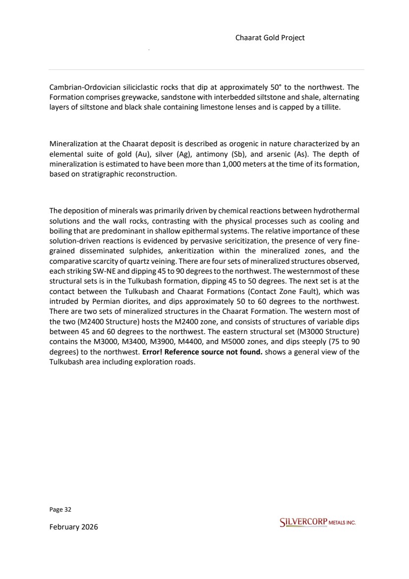
| Page 33 February 2026 Chaarat Gold Project Chatkal district, Kyrgyzstan NI 43-101 Technical Report Mineral Resource Update Figure 4.2: View towards the SW of the Tulkubash area; Chaarat Gold Project. Photo from site visit 14/9/2025. 4.2. PROPERTY DESCRIPTION AND OWNERSHIP The Chaarat Project is geographically positioned in western Kyrgyzstan Jalal-Abad Oblast, within the Chatkal district. The project area is specifically found in the southeastern portion of the Sandalash mountain range, situated to the northwest of the Sandalash River, about 300 km from the capital Bishkek. The Project site is situated adjacent to the Sandalash River, at an elevation of 2,100 to 3,600 masl. A combination of exploration programs has been implemented at the project, incorporating surface and underground core drilling. Further geological data has been gathered through chip and channel sampling from road cuts, trenching across mineralised structures exposed at surface, and systematic chip channel sampling along the ribs of underground workings. |
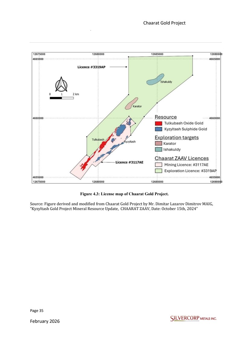
| Page 34 February 2026 Chaarat Gold Project Chatkal district, Kyrgyzstan NI 43-101 Technical Report Mineral Resource Update 4.3. MINERAL TENURE AND STATUS The following information was provided and checked by the technical and legal department of Chaarat ZAAV, Ms. Aliia Amangalieva, Mr. Janybek Baslakunov and Mr. Evgenii Bocharnikov. October 23, 2025. Chaarat Zaav CSJC, a wholly owned subsidiary of Silvercorp currently holds two licenses controlling the property: “Mining license (#3117AE) of 700 ha, valid to 2032, and covering the defined Mineral Resources and Mineral Reserves of the Kyzyltash and Tulkubash gold projects. “ “Exploration license (#3319AP) of 2,743 ha, valid until September 2026 which covers prospective areas to the northeast of the mining license, including Karator oxide gold prospect and Ishakuldy exploration target. The exploration license was recently extended until 07 September 2026 and is subject of further extension or conversion to a Mining license.“ |
| Page 35 February 2026 Chaarat Gold Project Chatkal district, Kyrgyzstan NI 43-101 Technical Report Mineral Resource Update Figure 4.3: License map of Chaarat Gold Project. Source: Figure derived and modified from Chaarat Gold Project by Mr. Dimitar Lazarov Dimitrov MAIG, “Kyzyltash Gold Project Mineral Resource Update, CHAARAT ZAAV, Date: October 15th, 2024” |
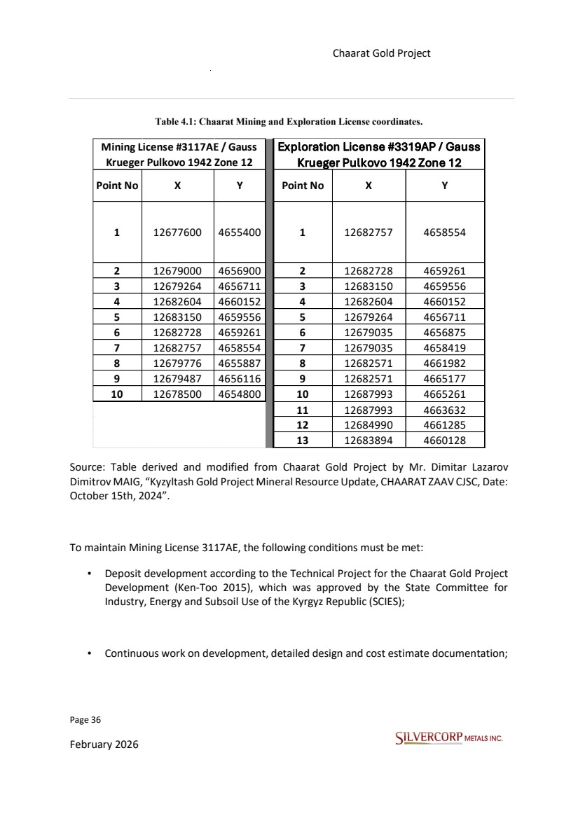
| Page 36 February 2026 Chaarat Gold Project Chatkal district, Kyrgyzstan NI 43-101 Technical Report Mineral Resource Update Table 4.1: Chaarat Mining and Exploration License coordinates. Point No X Y Point No X Y 1 12677600 4655400 1 12682757 4658554 2 12679000 4656900 2 12682728 4659261 3 12679264 4656711 3 12683150 4659556 4 12682604 4660152 4 12682604 4660152 5 12683150 4659556 5 12679264 4656711 6 12682728 4659261 6 12679035 4656875 7 12682757 4658554 7 12679035 4658419 8 12679776 4655887 8 12682571 4661982 9 12679487 4656116 9 12682571 4665177 10 12678500 4654800 10 12687993 4665261 11 12687993 4663632 12 12684990 4661285 13 12683894 4660128 Exploration License #3319AP / Gauss Krueger Pulkovo 1942 Zone 12 Mining License #3117AE / Gauss Krueger Pulkovo 1942 Zone 12 Source: Table derived and modified from Chaarat Gold Project by Mr. Dimitar Lazarov Dimitrov MAIG, “Kyzyltash Gold Project Mineral Resource Update, CHAARAT ZAAV CJSC, Date: October 15th, 2024”. To maintain Mining License 3117AE, the following conditions must be met: • Deposit development according to the Technical Project for the Chaarat Gold Project Development (Ken-Too 2015), which was approved by the State Committee for Industry, Energy and Subsoil Use of the Kyrgyz Republic (SCIES); • Continuous work on development, detailed design and cost estimate documentation; |
| Page 37 February 2026 Chaarat Gold Project Chatkal district, Kyrgyzstan NI 43-101 Technical Report Mineral Resource Update • Paying taxes on the right to subsoil use within the terms stipulated by Kyrgyz Republic legislation; • Submitting a social package to SCIES, including an investment program for improving conditions for local community development, which consists of training, providing jobs for residents of the local communities, and infrastructure development; • Opening a disturbed land rehabilitation account and accumulating funds defined by the Technical Project Report (Ken-Too 2015) for the Chaarat Gold Deposit Development. • The main conditions to hold Exploration License 3319AP include: • Paying taxes and other payments for subsoil use per Kyrgyz Republic legislation; • Informing SCIES on a quarterly basis about License retention fee payments and provide copies of all payment documents; • Providing geological reports to the State Geological Fund, as required under Kyrgyz Republic legislation; • Opening a disturbed land rehabilitation account and accumulate the amount of funds as defined by the Technical Project Report (Ken-Too 2015) for the Chaarat Gold Deposit Development. |
| Page 38 February 2026 Chaarat Gold Project Chatkal district, Kyrgyzstan NI 43-101 Technical Report Mineral Resource Update Source: “Main conditions and mainting Mining License” derived from Chaarat Gold Project by Mr. Dimitar Lazarov Dimitrov MAIG, “Tulkubash Gold Project Mineral Resource Estimate, date: April 2022” and “Kyzyltash Gold Project Mineral Resource Update, CHAARAT ZAAV CJSC, Date: October 15th, 2024” Since Chaarat ZAAV, a wholly owned subsidiary of Silvercorp is the legal owner of the property in Table 4.1, it has no obligations such as required exploration expenditures or payments to third parties to maintain title to the property, other than the agreed payments to the Kyrgyz government. Additionally, to keep the licences in good standing, the company must comply with the conditions of protection of the licenses, such as presentation of legal work, request for measurement of mining property, payment of the mining canon and compliance with the Plan and Amount of Investments. “The company is not the owner of the lands. Chaarat ZAAV has temporary rights to use land plots.” 4.4. SURFACE LAND USE PERMITS Silvercorp holds the required local and state government consents in the Chatkal Region to explore under License 3319AP. Pursuant to Mining Licence Agreement No. 4 for Mining Licence 3117AE, as submitted to the SCIES, temporary land-use rights are granted. These rights pertain to the land parcels delineated by the coordinates in said agreement and to parcels within the Kanysh-Kiya Ayil Okmotu territory allocated for the construction of infrastructure facilities. The dimensions, designated use, and expiry for each land parcel are itemized in Table 4.2. |
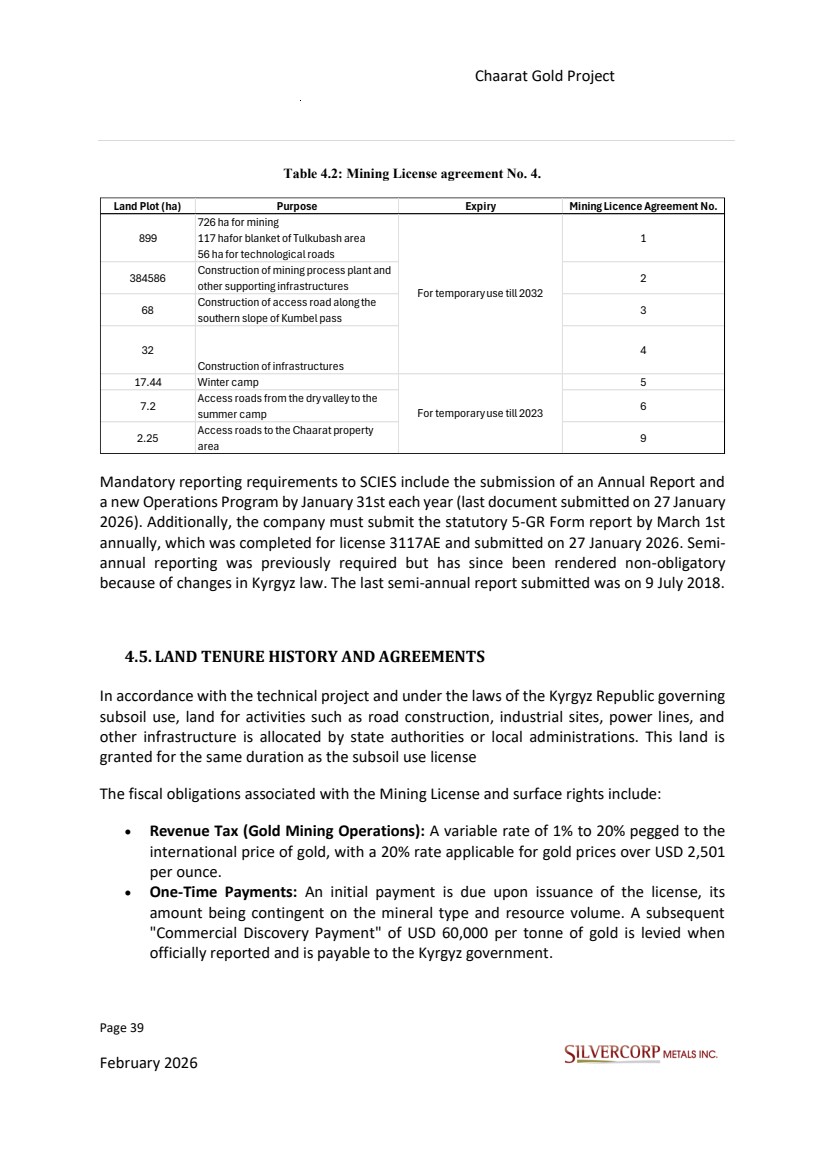
| Page 39 February 2026 Chaarat Gold Project Chatkal district, Kyrgyzstan NI 43-101 Technical Report Mineral Resource Update Table 4.2: Mining License agreement No. 4. Mandatory reporting requirements to SCIES include the submission of an Annual Report and a new Operations Program by January 31st each year (last document submitted on 27 January 2026). Additionally, the company must submit the statutory 5-GR Form report by March 1st annually, which was completed for license 3117AE and submitted on 27 January 2026. Semi-annual reporting was previously required but has since been rendered non-obligatory because of changes in Kyrgyz law. The last semi-annual report submitted was on 9 July 2018. 4.5. LAND TENURE HISTORY AND AGREEMENTS In accordance with the technical project and under the laws of the Kyrgyz Republic governing subsoil use, land for activities such as road construction, industrial sites, power lines, and other infrastructure is allocated by state authorities or local administrations. This land is granted for the same duration as the subsoil use license The fiscal obligations associated with the Mining License and surface rights include: • Revenue Tax (Gold Mining Operations): A variable rate of 1% to 20% pegged to the international price of gold, with a 20% rate applicable for gold prices over USD 2,501 per ounce. • One-Time Payments: An initial payment is due upon issuance of the license, its amount being contingent on the mineral type and resource volume. A subsequent "Commercial Discovery Payment" of USD 60,000 per tonne of gold is levied when officially reported and is payable to the Kyrgyz government. Land Plot (ha) Purpose Expiry Mining Licence Agreement No. 899 726 ha for mining 117 hafor blanket of Tulkubash area 56 ha for technological roads 1 384586 Construction of mining process plant and other supporting infrastructures 2 68 Construction of access road along the southern slope of Kumbel pass 3 32 Construction of infrastructures 4 17.44 Winter camp 5 7.2 Access roads from the dry valley to the summer camp 6 2.25 Access roads to the Chaarat property area 9 For temporary use till 2032 For temporary use till 2023 |
| Page 40 February 2026 Chaarat Gold Project Chatkal district, Kyrgyzstan NI 43-101 Technical Report Mineral Resource Update • Royalty on Production: A 5% charge on the revenue from all gold sales. • Sales tax: A 2% charge on the revenue from all gold sales. • Real Estate Tax (Land): Calculated according to the dimensions of the land parcel. • Real Estate Tax (Property): Calculated based on the size or value of the property. • Tax on Personal Income: A flat rate of 10%. Non-Tax Obligations: Tax Obligations: • License Retention Fees: The rates for these fees are variable, depending on the Mineral Resource, the size of the license area and the operational year of the license. A special formula per SCEIS guidelines is used for calculation. • Local Infrastructure Levy: A 2% charge on revenue is allocated for local infrastructure projects. 4.6.ROYALTIES All mineral properties that make up the Chaarat gold Project are not royalty free, and only in the case of entering into production will the royalties be established. The only royalties on mineral production regarding the mineral properties are those payable to the government of the Kyrgyz Republic. It is a combination of production rights, with a 5% charge on the income from all gold sales from the mining property, as well as a variable revenue tax rate ranging between 1 to 20% based on gold prices per ounce on the international market, and a 2% sales tax. This sensitive combination, according to comments from the technical and legal team from Chaarat ZAAV, would result in a total royalty/tax payment of 27% to the Kyrgyz government based on current gold prices which are above USD2,501 per ounce. 4.7. ENVIRONMENTAL REGULATIONS Under Kyrgyz law, Silvercorp is legally accountable for meeting all environmental requirements and adhering to approved design specifications. This includes measures for air and water resource protection, as well as land protection and rehabilitation. The company is required to obtain the necessary environmental permits (EIA/OVOS) and make quarterly payments for environmental pollution. |
| Page 41 February 2026 Chaarat Gold Project Chatkal district, Kyrgyzstan NI 43-101 Technical Report Mineral Resource Update 4.8.WORKS PERMITTING To advance the project, Silvercorp must supplement its existing Mining Licence (3117AE) and surface rights by obtaining a series of additional permits and licenses for construction and operations. “These are the main permits, but since legislation changes periodically, it may be necessary to check this list for the start of construction”. These requirements are categorized as follows: Design and Construction Approvals • Technical Design Expertise: Approval required for industrial safety, environmental safety (EIA/OVOS), and subsoil protection. • Design Legalization: In-country validation (local adaptation) is required for designs from foreign firms. • State Construction Review: A mandatory expert review of all final design documentation. • Facility Commissioning: Formal government acceptance of completed construction. Operational Permits • Permit to perform mining works. • License for underground water usage. • Approved emergency plan. Environmental Permits • Permit for air pollution emissions. • Permit for water pollutant discharge. • Permit for waste disposal. • License for activities involving toxic waste (utilization, storage, disposal). Safety and Hazardous Materials Permits • License/Permit for the import, sale, or purchase of explosive materials. • Permit for storing explosive materials. • Permit for conducting blasting works. • Permit for transporting hazardous goods. Compliance Certifications • Certification of all machinery and equipment. |
| Page 42 February 2026 Chaarat Gold Project Chatkal district, Kyrgyzstan NI 43-101 Technical Report Mineral Resource Update • Proper certifications for all relevant staff. Silvercorp will initiate the process to obtain these authorizations before starting construction and is confident that they will be granted in compliance with Kyrgyz legislation. 4.9. CLOSURE CONSIDERATIONS Closure must be covered by submission of a new or an update/amendment to an existing approved plan. The document must include details of the proposed environmental rehabilitation, reclamation or adjustment activities and discuss how post-closure environmental impacts will be avoided. “In accordance with the requirements of the legislation, the plan for the reclamation and liquidation/conservation of mining property is part of the technical project.” 4.10. SURFACE RIGHTS The Kyrgyz Republic set out rules and laws under which surface rights and easements can be granted for a mining operation and covers aspects including land occupation, rights-of-way, access routes, transport routes, rail lines, water usage and any other infrastructure needed for operations. In the case of the Chaarat Gold Project, the surface rights of the two licenses, the mining license (No. 3117AE) covering 700.03 ha and the exploration license (No. 3319AP) covering 2,743 ha, are inactive areas with no residents or livestock, which means there are no relocation costs. |
| Page 43 February 2026 Chaarat Gold Project Chatkal district, Kyrgyzstan NI 43-101 Technical Report Mineral Resource Update 5. ACCESSIBILITY, CLIMATE, LOCAL RESOURCES, INFRASTRUCTURE AND PHYSIOGRAPHY 5.1. ACCESSIBILITY Access to the Chaarat Gold Property in Kyrgyzstan is primarily available via two distinct routes from the capital city of Bishkek. An alternative route provides seasonal access. The preferred route for future development, particularly for transporting hazardous materials and large equipment, is a 750-kilometer paved and gravel road that travels through the city of Ala-Buka. The journey on this southern route takes approximately 12 to 20 hours and generally requires an overnight stop in Ala-Buka. This route provides nearly year-round access to the property. In winter (October to April), travel is restricted to 20-foot container trucks equipped for winter conditions, with continuous support from grading or loading equipment. A shorter alternative route to the Chaarat Property is available through the Chatkal Valley via Talas and the village of Kyzyl Adyr. This 520-kilometer journey takes approximately 12 to 14 hours. However, this route is not suitable for heavy vehicles over 12 tonnes and is impassable during the winter and spring months due to snow on the high mountain passes of Kara Bura and Kumbel. The seasonal access for this route is limited to June through October. Regarding rail logistics, the closest town to the Shamaldy-Say train station is Ala-Buka, situated about 300 kilometers from the property. At the time of the original assessment, this station was not equipped to handle goods destined for the Tulkubash project. Another railway station in Maymak, 195 kilometers to the north, is considered impractical for delivering large equipment and hazardous materials. This is due to the challenging transportation route from Maymak, which crosses three high mountain passes and navigates the narrow Chichkan valley. |
| Page 44 February 2026 Chaarat Gold Project Chatkal district, Kyrgyzstan NI 43-101 Technical Report Mineral Resource Update Figure 5.1: Location of the Chaarat Gold Project and access routes. Source: Figure derived and modified from Chaarat Gold Project by Mr. Dimitar Lazarov Dimitrov MAIG, “ Kyzyltash Gold Project Mineral Resource Update, CHAARAT ZAAV CJSC, Date: October 15th, 2024”. 5.2. CLIMATE The Project climatic profile is elevation-dependent, featuring a semi-arid to temperate humid climate in its lower zones. In contrast, the high alpine zones are subject to severe winter conditions, including frequent snowstorms and avalanches. The snow-free period in the lower elevations lasts from March to December, whereas in the higher elevations, it is restricted to June through October; the mountain summits remain perennially snow-covered. Average annual precipitation is 460 mm, occuring as snowfall between October and February and rainfall from March to May, followed by a dry period from June to September. There is significant seasonal temperature variability within the Jalal-Abad province, with averages |
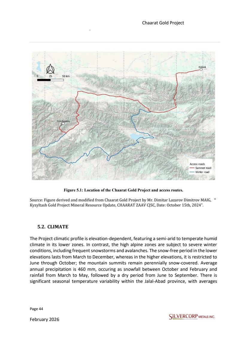
| Page 45 February 2026 Chaarat Gold Project Chatkal district, Kyrgyzstan NI 43-101 Technical Report Mineral Resource Update ranging from a high of 26°C in summer to a low of -20°C in winter. The prevailing wind direction is north-westerly. 5.3. LOCAL RESOURCES AND INFRASTRUCTURE The Chatkal Valley administrative region encompasses eight villages with a total population of 13,000. The area is characterized by economic isolation and a reliance on livestock breeding as the principal form of subsistence. The Sandalash Valley, which hosts the Chaarat Gold Property, is uninhabited and devoid of agricultural activity, although it is utilized seasonally by herders for livestock transit. The Sandalash Valley currently lacks electrical power infrastructure. A 110kV power transmission line is located approximately 40km from the property, servicing the Kuru-Tegerek mining operation. A separate 10kV transmission line, which provides power to the villages in the Chatkal Valley, is situated 30km from the Chaarat Property. After assessing three potential power supply options: a connection to the national grid, on-site diesel generation, and a local hydropower facility, the project has been designed to utilize diesel generators located at the property. 5.4. PHYSIOGRAPHY The Property is situated in a region of extreme relief, with elevations extending from the Sandalash Valley at 2,000 m to mountain ranges peaking at 4,200 masl. The Sandalash Valley is characterized by its narrow width, ranging from 100 to 300 m, and is bounded by steep slopes. The Sandalash River exhibits a linear, south-westerly trend and a moderate gradient within the Property area. It flows into the Chatkal River south of the Property. Both river systems are subject to significant spring flooding from snowmelt, which can render them temporarily impassable. |
| Page 46 February 2026 Chaarat Gold Project Chatkal district, Kyrgyzstan NI 43-101 Technical Report Mineral Resource Update 6. HISTORY 6.1. EXPLORATION HISTORY Pre-1992 Soviet Era: Initial antimony discovery by Soviet geologists. Regional stream sediment programs identified gold, silver, and tungsten anomalies. Three exploration drifts (660 m total) were developed at Tulkubash and Kyzyltash. 1996-2000 Post-Soviet Era: The license was acquired by Apex Asia, which formed a joint venture with Newmont. Newmont completed geophysical surveys and 1,803 m of drilling before exiting the project. 2002-2004 Initial Success: The previous project owner acquired the license in 2002. A 2004 exploration program confirmed significant gold mineralization, including an intercept of 8.3 m @ 7.0 g/t Au. 2004-2005 Tulkubash Discovery: Soil sampling at Tulkubash identified extensive high-grade gold anomalies. An initial 2005 drill hole intersected 17.1 m @ 4.61 g/t Au. 2006-2013 Kyzyltash Focus: Systematic drilling campaigns targeted the Kyzyltash Main and Contact zones, culminating in a 2013 Mineral Resource estimate across nine mineralized bodies. Mineralization was confirmed over a 1 km vertical extent. 2010 Strategic Shift: Metallurgical test work indicated Tulkubash mineralization was free-milling and suitable for a heap leach operation. This finding prompted a strategic pivot, with exploration efforts after 2014 focused exclusively on the Tulkubash oxide deposit. Exploration and development activities at Tulkubash were reduced from 2013 to 2016, including a halt in drilling in 2015. Drilling intensity increased sharply thereafter, totalling 17,420 meters in 2017, and 50,319 meters between 2018 and 2023. In 2023, 16 metallurgical holes were drilled at Kyzyltash totalling 3,508m. The 2020 field season was significantly curtailed by COVID-19. The current Mineral Resource estimate for Tulkubash is based on data compiled up until 2023. The current MRE includes an additional 16 holes (2023 metallurgical holes) that were drilled after the completion of the prior Mineral Resource estimate report by GeoSystems International Inc. “Chaarat Gold Project, Republic of Kyrgyzstan, effective date report: 19 October 2014”. The geotechnical and hydrogeological understanding of the Main Pit concept area of Tulkubash was improved upon by the addition of 13 oriented drill holes (1,550 m total) in the |
| Page 47 February 2026 Chaarat Gold Project Chatkal district, Kyrgyzstan NI 43-101 Technical Report Mineral Resource Update year 2021, 12 of which provided numerical data for geotechnical and hydrogeological modelling. Table 6.1: Historic drilling statistics for Au assay results (g/t) at Tulkubash. Table 6.2: Historic drilling statistics for Au assay results (g/t) at Kyzyltash. Tables 6.1 and 6.2 do not include statistical analyses of the Karator and Ishakuldy holes. 6.2. HISTORICAL MINERAL RESOURCE ESTIMATES Several independent Mineral Resource estimates and audits have been conducted on the Chaarat Gold Project since exploration began, including: -SRK consulting (Update of Mineral Resource Estimates, for Chaarat Gold Project, Kyrgyzstan, Feb. 2010). -Wardell Armstrong (Tulkubash Resource Modelling, Apr.2011). |
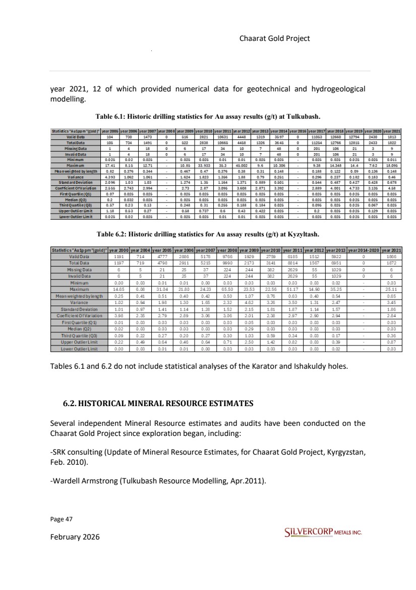
| Page 48 February 2026 Chaarat Gold Project Chatkal district, Kyrgyzstan NI 43-101 Technical Report Mineral Resource Update -Gustavson Associates (Chaarat Gold Project Resource Estimation, June 2014). -JORC: GeoSystems International Inc. (Chaarat Gold Project, Republic of Kyrgyzstan, effective date report: 19 october 2014). -JORC: Mineral Resource update, Tulkubash zone, Republic of Kyrgyzstan, Effective Date of Report: 5 February 2017. -WAI (2017a). Chaarat Gold Holdings Ltd. Tulkubash Heap Leach Feasibility Study Hydrology Report for the Heap Leach Facility. May 2017. -WAI (2017b). Chaarat Gold Holdings Ltd. Tulkubash Gold Project, Kyrgyzstan Report on Metallurgical Testing Conducted as Part of a Feasibility Study. 24th August 2017. -WAI (2018). Environmental and Social Impact Assessment in Support of the Chaarat Gold Feasibility Study (Phase 1 – Tulkubash) in Kyrgyzstan. Chapter 3 – Project Description. -Tetra Tech (Competent Person Report for Chaarat Gold Project, Kyzrgyz Republic, Dec.2018). -Sound Mining (Competent Person’s Report on Tulkubash Gold Project, for Chaarat Gold Holdings Limited, Jan 2019). -LogiProc (Tulkubash Gold Project Bankable Feasibility Study Update Report, Aug.2019). -Wardell Armstrong (Review of Modelling Estimation and Classification, based on Resource Model, provided by IGT up to June 2020). -Roscoe Postle Associates Inc. (RPA), part of SLR Consulting (RPA Due Diligence of Tulkubash Resource Model, based on Resource Model provided by IGT). -Institute of Geotechnologies (IGT) (The Tulkubash Gold Project Mineral Resource Estimate, for Chaarat ZAAV SJSC, Dec. 2020). |
| Page 49 February 2026 Chaarat Gold Project Chatkal district, Kyrgyzstan NI 43-101 Technical Report Mineral Resource Update 7. GEOLOGICAL SETTING AND MINERALIZATION 7.1. REGIONAL GEOLOGY The Chaarat Property is situated within the Tien Shan Metallogenic Belt, an extensive Hercynian-age fold-and-thrust belt that extends for over 2,500 km. This belt is composed of three primary tectono-stratigraphic units, interpreted as accretionary terranes that developed on the margin of the proto-Eurasian continent. The Chaarat Gold property lies specifically within the Middle Tien Shan province, which is comprised of tectonic fragments of Ordovician to Carboniferous age. The Middle Tien Shan province forms a sub-latitudinal corridor, 20-100 km wide, bounded to the north by the Nikolayev’s Fault. The major Talas-Fergana transverse fault divides the province into two distinct sectors: the Naryn (eastern) and the Chatkal (western), where the property is located. The southern boundary is defined by the Kara-Suu Fault in the Chatkal sector. These sectors exhibit different structural orientations; folds in the Chatkal region trend northeast, rotating to a southeast trend in proximity to the Talas-Fergana Fault. The metallogeny of the Middle Tien Shan is diverse, hosting several major deposits. Mineralization styles are genetically linked to orogenic gold, porphyry, and skarn systems, which are closely associated with structurally controlled Late Carboniferous and Permian magmatism. The Chaarat Gold project is situated within the Tien Shan gold belt, which extends across Central Asia from Uzbekistan in the west through to China in the east, and hosts a number of large deposits including Muruntau (175 million oz.), Daugyztau (18 million oz.), Zarmitian (11 million oz.) and Kumtor (18 million oz.). |
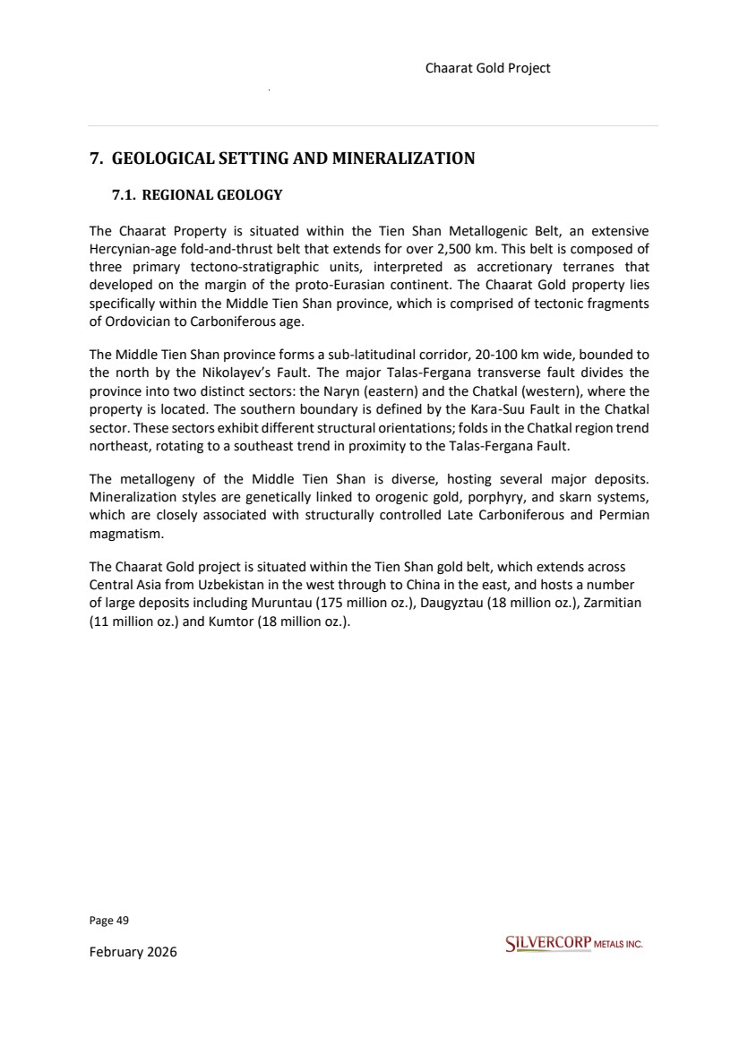
| Page 50 February 2026 Chaarat Gold Project Chatkal district, Kyrgyzstan NI 43-101 Technical Report Mineral Resource Update Figure 7.1: Chaarat Project Location in Tien Shan Belt. Source: Figure derived and modified from Chaarat Gold Project: “Mineral Resource update, Tulkubash zone, Republic of Kyrgyzstan, Effective Date of Report: 5 February 2017”. The mineralization at the Chaarat gold project is fundamentally controlled by the Sandalash Fault Zone (SFZ), a major structural corridor located approximately 35 km southwest of the Talas-Fergana Fault. The terrain is intensely deformed by polyphase structural events, dominated by thrusts, folds, and oblique strike-slip faults. The SFZ is defined by a series of subparallel brittle-ductile shear structures resulting from predominantly strike-slip displacement. Gold mineralization is hosted within dilatant extensional structures (e.g., jogs, pressure shadows) that formed during faulting events. The SFZ comprises three mineralized fault zones—the Tulkubash Structural Zone, the Contact Fault, and the Main Zone Fault—and one unmineralized structure, the Irisay Fault. The structural framework of the Chaarat deposit is the result of multiple tectonic events, primarily from the Caledonian and Hercynian orogenies, with subsequent reactivation during the Alpine orogeny. |
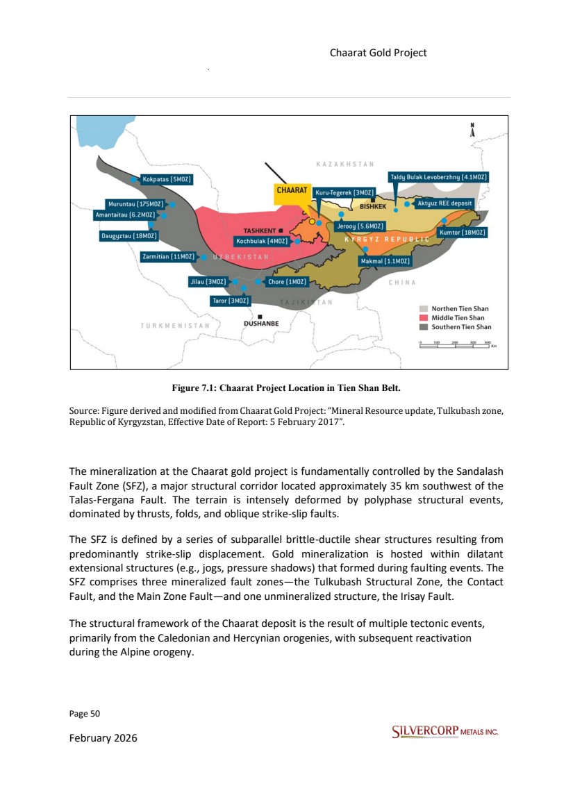
| Page 51 February 2026 Chaarat Gold Project Chatkal district, Kyrgyzstan NI 43-101 Technical Report Mineral Resource Update Figure 7.2: Chaarat ore field structural control, Sandalash Shear zone Source: Figure derived from LogiProc. Bankable Feasibility Study Update Report, Tulkubash Gold Project, 2021. The earliest significant deformation involved Caledonian-age (Late Ordovician) folding and the intrusion of granitoid plutons. Structures from this period include linear, northeast-striking folds and associated longitudinal reverse faults. The Main Zone at the Chaarat project is interpreted as a primary example of a Caledonian structure, representing a large-scale fault with complex shear-thrust kinematics. The fault zone contains S-C ductile tectonites overprinted by later brittle cataclasites and mylonites. It is hypothesized that the initial gold-bearing quartz-sulphide vein-stockwork mineralization in the Main Zone may have formed during this Late Ordovician event. This mineralization could |
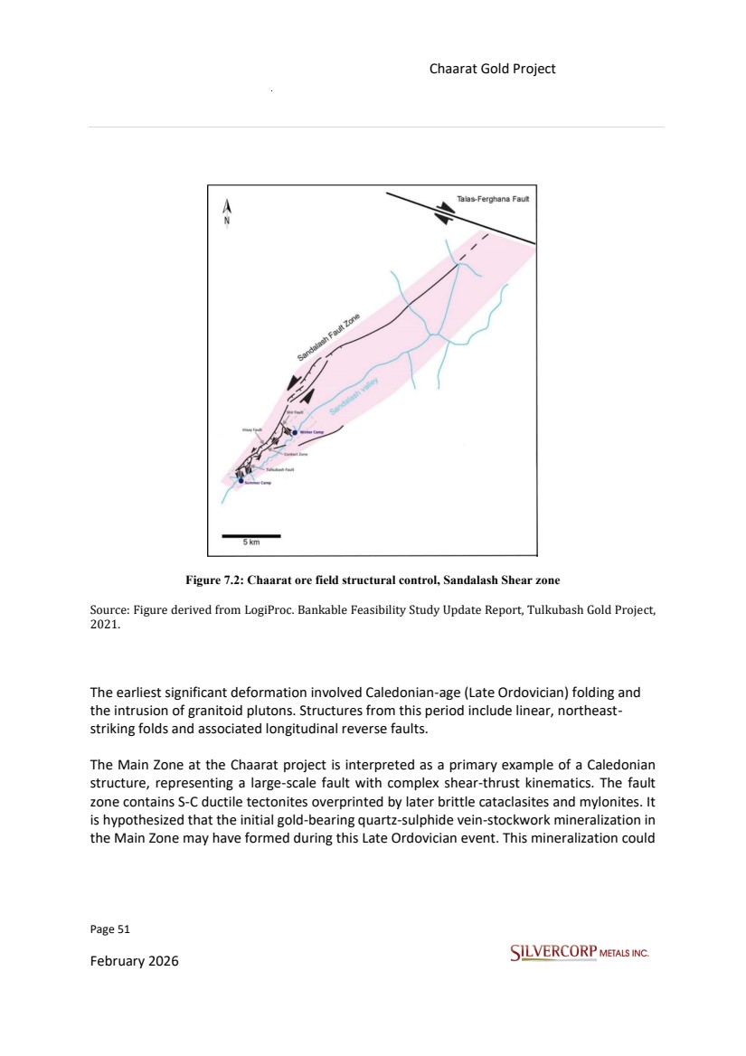
| Page 52 February 2026 Chaarat Gold Project Chatkal district, Kyrgyzstan NI 43-101 Technical Report Mineral Resource Update have been subsequently remobilized and reconcentrated within structural traps during the later Hercynian Orogeny. The Hercynian orogeny was the primary mineralization period for the Chatkal region. This stage was characterized by complex shear tectonics and at least two phases of folding, which created a complex interference pattern of intersecting linear and brachimorphic folds, particularly evident at the Tulkubash deposit. During the Late Paleozoic (Middle Carboniferous–Permian), mineralization and granitoid intrusions were emplaced along three dominant structural trends: WNW, ENE, and NNE. These trends are interpreted to reflect deep-seated crustal discontinuities or basement faults that acted as conduits for magma and hydrothermal fluids. The controlling shear zones exhibit pre-, syn-, and post-mineralization activity, indicating a long-lived and dynamic system. The Chaarat Deposit is strategically located at the intersection of the mineralized NE and NNE-striking structural trends, a setting highly favorable for significant metal deposition. 7.2. PROPERTY GEOLOGY The Sandalash River valley exposes a northeast-trending sequence of Cambro-Ordovician siliciclastic rocks of the Chaarat Formation. This unit is overlain by Devonian-age quartzites of the Tulkubash Formation. The sedimentary host rocks strike northeast and dip between 40° and 75° to the northwest. The entire sequence is intruded by Permo-Triassic granodiorite and diorite bodies, which are closely associated with gold mineralization and are themselves locally mineralized. Chaarat Formation The Chaarat Formation is composed of three members that display a sequential package of alternating, moderately- to well-bedded, dark-coloured siltstones, shales, quartzites, and greywackes, with minor limestone interbeds. (Cats et al. 2012). The lower member is up to 170 meters thick and consists of grey siliceous siltstone interbedded with minor dark siltstone and shale. The middle member has a thickness of approximately 300 meters. It is made up of interbedded fine- and medium-grained sandstones, greywackes, and siltstones, with a basal zone consisting of lenticular beds of polymictic gravelly conglomerates and sandstones. |
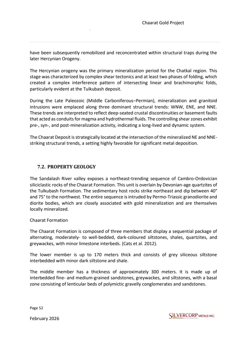
| Page 53 February 2026 Chaarat Gold Project Chatkal district, Kyrgyzstan NI 43-101 Technical Report Mineral Resource Update The upper member is predominantly composed of shales and rhythmically interbedded siltstones and fine-grained sandstones that commonly show graded bedding. This member has a thickness ranging from 70 to 90 meters, while the thickness of individual beds varies between 1 and 2 meters. Tulkubash Formation The Tulkubash Formation reaches a thickness of up to 1,000 meters and is comprised of medium- to fine-grained quartzites and medium- to coarse-grained arkosic sandstones, with occasional thin interbeds of dark pyritic shales and siltstones. The quartzite beds range from 10 centimeters to 1 meter in thickness, with the thicker beds being more prevalent. Individual quartzite beds are typically massive and internally homogenous, occasionally displaying compositional layering of dark laminae alternating with lighter quartz-rich layers. The base of the Tulkubash Formation is generally marked by a conglomerate unit. Within the Chaarat Property area, the upper and lower contacts of this formation are defined by faults. |
| Page 54 February 2026 Chaarat Gold Project Chatkal district, Kyrgyzstan NI 43-101 Technical Report Mineral Resource Update Figure 7.3: Chaarat ore field, Sandalash Shear zone, geology and mineralization. Source: Figure derived and modified from Chaarat Gold Project by Mr. Dimitar Lazarov Dimitrov MAIG, “ Kyzyltash Gold Project Mineral Resource Update, CHAARAT ZAAV CJSC, Date: October 15th, 2024”. 7.3. STRUCTURAL GEOLOGY The Chaarat Property and associated mineralization is hosted by the Sandalash Fault Zone (SFZ), a tectonic feature composed of several subparallel brittle shear zones. The movement along the SFZ is primarily a sinistral (left-lateral) strike-slip, and this displacement has led to |
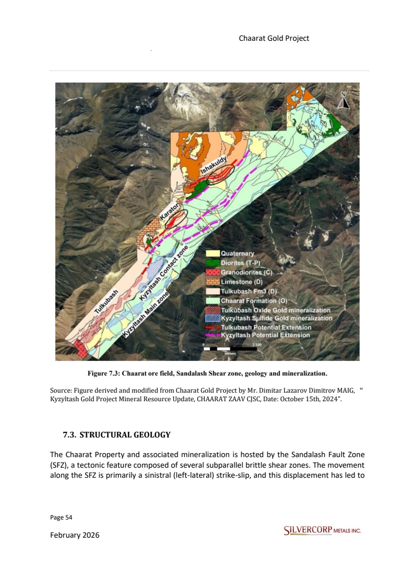
| Page 55 February 2026 Chaarat Gold Project Chatkal district, Kyrgyzstan NI 43-101 Technical Report Mineral Resource Update the formation of various extensional structures. These structures, created by pressure relief during faulting, are where gold mineralization occurs (Kramer, 2009; Jakubiak, 2017). The SFZ is further subdivided into three mineralized zones—the Tulkubash Structural Zone, the Contact Fault, and the Main Zone Fault—and one zone without mineralization, the Irisay Fault. Drilling strategies have varied, with drill hole orientation being influenced by practical considerations like access, and by the evolving geological interpretations over time. For example, some of the earlier drilling at Tulkubash was oriented parallel to the geological strike. This was a deliberate choice to target silicified zones exposed at the surface, which are oriented perpendicular to the key mineral-controlling structures. Despite these variations, the general approach to exploration, including drilling, trenching, and subsurface sampling, is to orient these activities at oblique and perpendicular angles to the main mineralized trends. Importantly, sampling has been conducted in both mineralized and the adjacent barren rock in most areas. This comprehensive sampling approach has prevented any biases or interpretational artifacts related to orientation from appearing in the project database or geological models. |
| Page 56 February 2026 Chaarat Gold Project Chatkal district, Kyrgyzstan NI 43-101 Technical Report Mineral Resource Update Figure 7.4: Scheme of the orogenic gold deposit as a function of depth in the crust (Groves et al., 1998), with modifications. Source: Figure derived and modified from Chaarat Gold Project by Mr. Dimitar Lazarov Dimitrov MAIG, “ Kyzyltash Gold Project Mineral Resource Update, CHAARAT ZAAV CJSC, Date: October 15th, 2024”. 7.4. MINERALIZATION The mineral endowment is concentrated in three main zones Kyzyltash (Contact, Main), and Tulkubash. These zones, while geologically distinct, all demonstrate significant continuity of mineralization. On-site inspection of the Tulkubash zone by SVM’s geological team afforded a critical three-dimensional understanding of the ore body, including observation of channel sampling and drill collar locations. This facilitates a more accurate interpretation of the shear zone's geometry and the true widths of mineralization. This report is specifically concerned with the Tulkubash zone, a mineralized shear that is characterized by its extensive strike continuity. All the mineralized zones share analogous geometries, with similar strikes and dips, and have been traced by outcrop mapping and diamond drilling for over a kilometre. Surface mapping and trenching have extended this known strike length for several kilometres. |
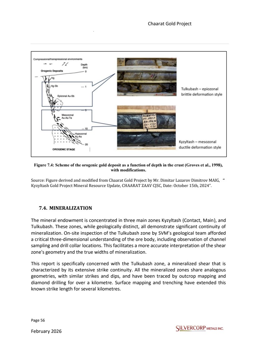
| Page 57 February 2026 Chaarat Gold Project Chatkal district, Kyrgyzstan NI 43-101 Technical Report Mineral Resource Update The Tulkubash zone is generally lower grade, however, due to the degree of oxidation the mineralized material is free milling; it is also typically wider than other mineralized zones within the Chaarat property. The presence of high-grade, cross-cutting stibnite veins, oriented sub-parallel to the section lines, has been documented. Distinctive visual markers, such as quartz-carbonate veining and shearing are indicative of the mineralized shear zone and will be valuable for grade control in a future mining operation. However, the friable nature of the mineralized core makes the identification of these same features in core boxes more problematic. The prediction of gold grades is not straightforward. The presence and location of the shear zone, even with clear visual evidence, is not a reliable proxy for estimating gold concentration. Additional geological features of interest have been noted within the Tulkubash zone. These include stibnite-bearing veins, occurring in zones between 1 and 3 meters in width that are sub-parallel to the section line and are generally associated with high gold grades. This mineral resource estimate update report considers separation of oxide (Tulkubash) and sulphide (Kyzyltash) portions of mineralization. 7.4.1. Tulkubash area The Tulkubash gold deposit is characterized by its oxidized, epithermal nature. Key features include colloform textures, widespread silicification, and a geochemical signature where gold is associated with antimony and arsenic. This evidence points to formation in a shallow geological setting, which can be classified as an epizonal orogenic gold deposit. The Tulkubash deposit has undergone a high degree of oxidation, which allows for the processing through conventional heap leach methods. An associated zone, known as the Karator deposit, is located about 2 kilometers northeast of the Tulkubash deposit. This zone exhibits the same geological and mineralization features as the Tulkubash deposit. It has been traced for over 800 meters along strike and has an approximate true width of 30 to 50 meters. The Karator zone is considered a potential northeastward continuation of the Tulkubash deposit. |
| Page 58 February 2026 Chaarat Gold Project Chatkal district, Kyrgyzstan NI 43-101 Technical Report Mineral Resource Update 7.4.2. Kyzyltash area The Kyzyltash gold deposit represents a deeper, mesozonal orogenic gold system. Its mineralization is distinguished by pervasive sericite alteration, disseminated sulphides, and ankeritization within the mineralized zones. It contains relatively few quartz veins (typically less than 5% by volume). This style indicates that the gold was deposited from reduced hydrothermal fluids interacting with more reactive wall rocks compared to Tulkubash. These types of deposits form under nearly constant temperature conditions and can extend to significant depths. For instance, drilling of the Kyzyltash Contact zone has confirmed mineralization over a vertical distance of 1.3 kilometers, and remains open at depth and along strike. The Kyzyltash deposit consists of two primary zones: the Contact Zone and the Main Zone. Nearly all the gold mineralization at Kyzyltash is refractory due to its association with other sulphide minerals such as arsenopyrite, meaning specialized processing methods are required to extract the gold. Detailed metallurgical studies are currently underway to determine the most effective processing method, which will inform a future Feasibility Study update. The Tulkubash and Kyzyltash deposits of the Chaarat property are situated in the transitional zone between “Epizonal Au-Sb” and “Mesozonal Au-As-Te” environments of the Orogenic Gold class of deposits. 7.4.3. Mineralization Model The Tulkubash zone is an intensely oxidized system, which differentiates it from the sulphide-dominant Kyzyltash zones. Oxidation is most prevalent at shallower depths and decreases with depth, featuring a mostly gradational oxide-sulphide contact that appears to be locally structurally controlled. The oxidized gold-bearing lodes are hematitic, contain free-milling gold, and are amenable to heap leach processing. The underlying sulphide mineralization, in contrast, is not currently economic due to the refractory nature of the gold. This sulphide material is composed primarily of pyrite and arsenopyrite, with quartz being the dominant gangue mineral. Widespread silicification is another key feature of Tulkubash that is absent in the Kyzyltash zone. The gold is a low-silver electrum, and overall silver grades are not economically significant. |
| Page 59 February 2026 Chaarat Gold Project Chatkal district, Kyrgyzstan NI 43-101 Technical Report Mineral Resource Update Figure 7.5: Chaarat project mineralization styles, Conceptual cross section. Source: Figure derived and modified from Chaarat Gold Project by Mr. Dimitar Lazarov Dimitrov MAIG, “ Kyzyltash Gold Project Mineral Resource Update, CHAARAT ZAAV CJSC, Date: October 15th, 2024”. |
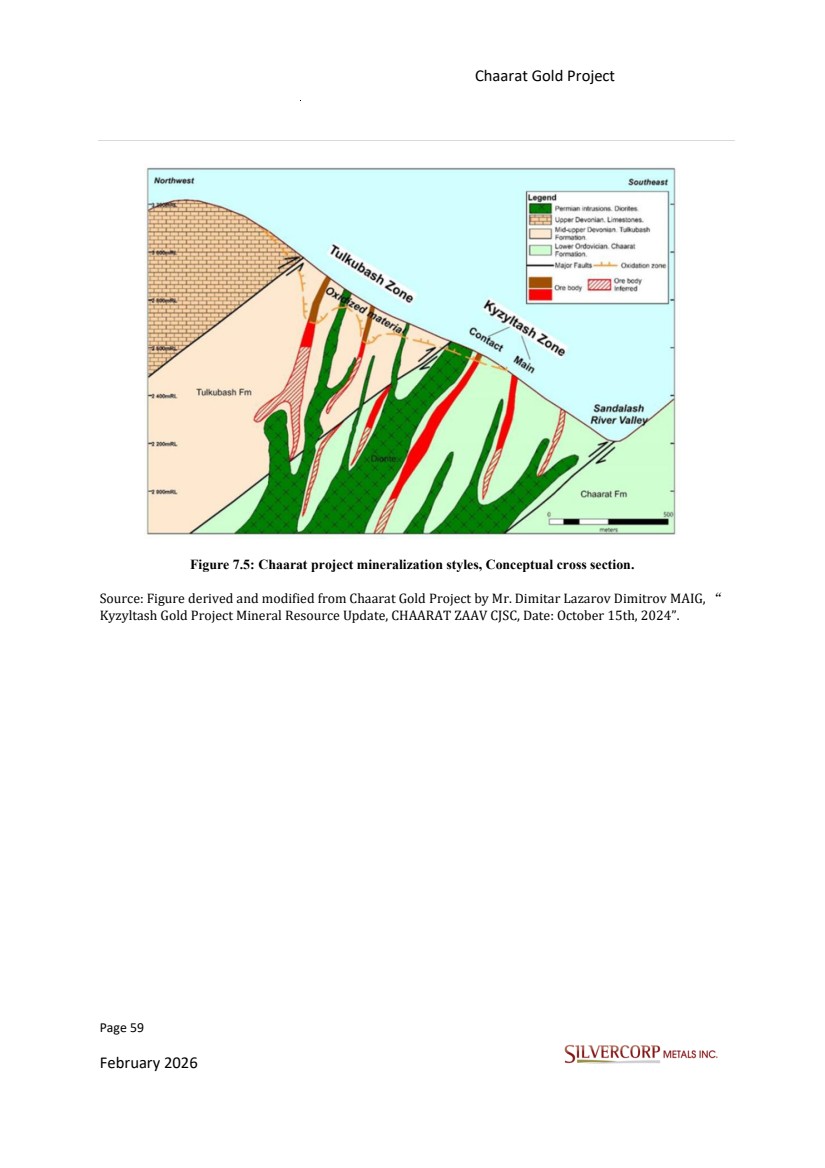
| Page 60 February 2026 Chaarat Gold Project Chatkal district, Kyrgyzstan NI 43-101 Technical Report Mineral Resource Update 8. DEPOSIT TYPES At the Chaarat Gold Project, gold mineralization and the related hydrothermal alteration are fundamentally linked to the emplacement of igneous intrusive rocks along a network of large-scale, sinistral, oblique-slip faults. This geological environment has given rise to two separate styles of mineralization, known as the Tulkubash-type and the Kyzyltash-type. Despite their distinct characteristics, the close spatial relationship and shared structural controls of these two types indicate they originated from a single, common mineralization event. The project is situated within the Tien Shan Metallogenic Belt, a Hercynian-age fold and thrust belt that stretches over 2,500 kilometers. This belt is comprised of three main tectono-stratigraphic units, separated by major structural zones, which are interpreted as accretionary prisms formed at the edge of the proto-Eurasian continent. The Chaarat project itself is located in the Middle Tien Shan province, which consists of Ordovician to Carboniferous rock fragments. The terrain has been subjected to intense structural deformation both before and after the mineralizing event, characterized by southeast and northwest-verging thrusts and steep, north-northeast striking strike-slip faults. Genetically, the mineralization is classified as having both "Orogenic" and "Intrusion-Related" characteristics. The system strikes to the northeast and is closely associated with structurally controlled magmatism during the Permian period. Contrasting Mineralization Styles Two primary types of host rock and mineralization are present in the deposit: • Tulkubash-Type: This is an oxidized form of gold mineralization. It is hosted within Devonian-aged silicified sandstones of the Tulkubash formation. The mineralization forms relatively steep, northeast-trending lenses that are controlled by a series of dilatational jogs (zones of extension). • Kyzyltash-Type: The second type is a sulphide-rich zone containing refractory gold. This mineralization is found in an Ordovician flysch complex, which is dominated by fine-grained black shales. These host rocks have locally been metamorphosed to greenschist facies and exhibit features of complex structural deformation and contact metasomatism. |
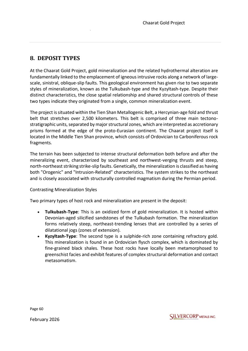
| Page 61 February 2026 Chaarat Gold Project Chatkal district, Kyrgyzstan NI 43-101 Technical Report Mineral Resource Update Figure 8.1: Zone of structurally hosted oxidation and alteration within the Tulkubash deposit. Source: Photo taken at project site on 14/09/2025. |
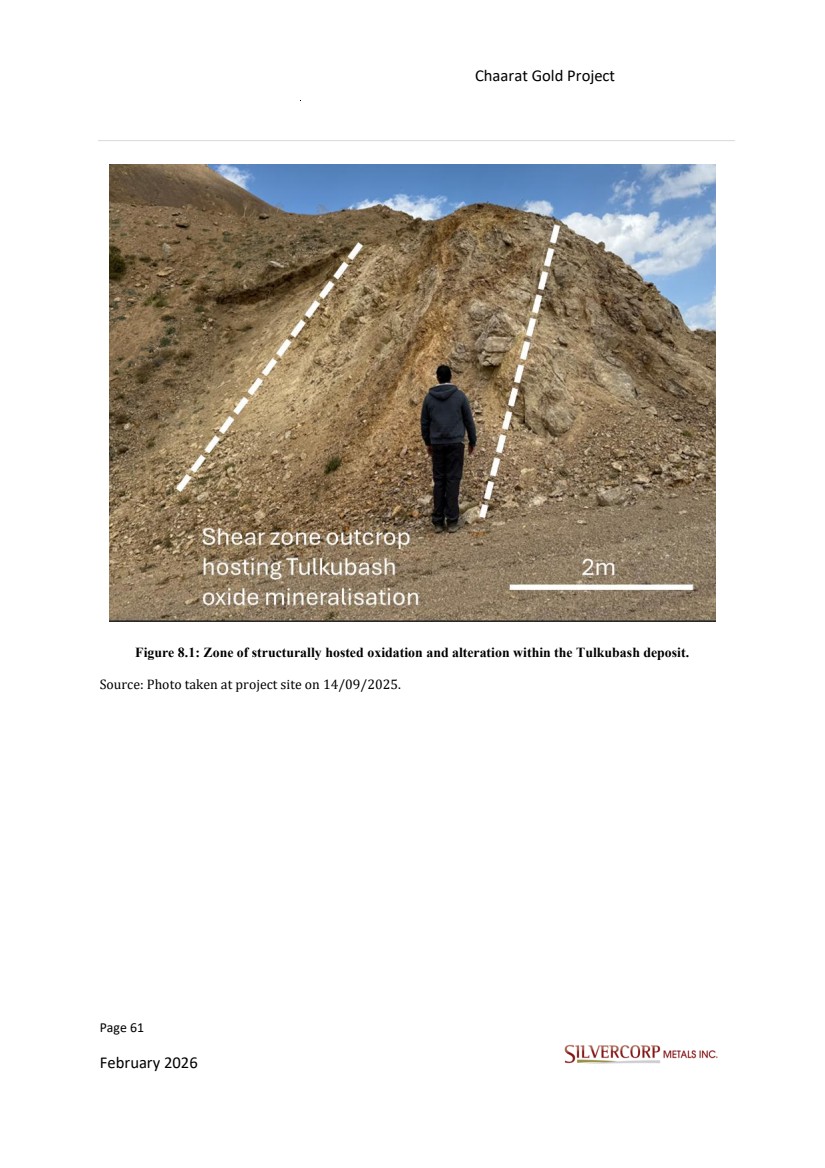
| Page 62 February 2026 Chaarat Gold Project Chatkal district, Kyrgyzstan NI 43-101 Technical Report Mineral Resource Update Figure 8.2: MD21M013 – Intensive sulfidation with quartz veining and brecciation of a mineralised intercept hosted in the Kyzyltash Main zone. Source: Photo taken at Chaarat ZAAV core storage facility on 12/09/2025. |
| Page 63 February 2026 Chaarat Gold Project Chatkal district, Kyrgyzstan NI 43-101 Technical Report Mineral Resource Update 9. EXPLORATION Extensive exploration and drilling have clearly defined the Tulkubash mineralization. Drilling has consistently confirmed the general geological model, which features mineralization trending southwest-northeast with a steep dip of -60 degrees to subvertical. This work has outlined zones with varying intercept lengths, thicknesses, and grades. Although certain areas along the strike ranging from 40 to 600 meters in length remain undrilled due to challenging topography and avalanche debris in gullies, the exceptional along-strike continuity of mineralization suggests these zones are likely connected. However, without drilling, no mineral resources can be estimated for these specific areas. Following the successful 2004 campaign, drilling efforts continued through 2005 and 2006 to further delineate the Kyzyltash Main and Contact Zone mineralization. In 2006, Chaarat ZAAV also initiated the development of an exploration adit to access the C54 area (now known as the CP Zone) of the Contact Zone. This adit served the dual purpose of providing underground platforms for down-dip drilling and for collecting bulk samples for metallurgical analysis. This phase of systematic project advancement, involving both surface and underground drilling, continued until 2013, by which time approximately 77,000 meters of diamond core had been drilled since 2000. At that point, the company shifted its focus to intensive exploration of the property's other key target, the Tulkubash oxide gold deposit. The extensive data gathered supported numerous resource estimates between 2011 and 2014, culminating in a 2014 Mineral Resource Estimate (MRE) prepared by GeoSystem International. This MRE was followed by further technical assessments of potential development scenarios, including the NERIN Feasibility Study in 2016 and earlier work by ABGM for the 2011 SNC-Lavalin Pre-Feasibility Study. Exploration activities at Kyzyltash resumed in 2021 and 2022, with a program that included approximately 3,500 meters of diamond core drilling, metallurgical testing, trenching, and geophysical surveys. The additional data from this recent work combined with the historical data from the projects has provided the basis for the current resource update, which aims to advance the geological and economic understanding of the deposit and improve the quality of available technical data. The exploration has generally been conducted in a thorough and professional manner, within an operational environment which the QP considers to be in accordance with industry standards. Therefore, the quality of the data used for resource estimation is good. |
| Page 64 February 2026 Chaarat Gold Project Chatkal district, Kyrgyzstan NI 43-101 Technical Report Mineral Resource Update 9.1. GEOPHYSICAL SURVEY Following the dissolution of the Soviet Union, Apex Asia gained control of the license in 1996 and subsequently entered into a joint venture with Newmont Overseas Exploration Limited. Newmont conducted a geophysical survey over parts of the Tulkubash and Kyzyltash areas and drilled seven holes for a total of 1,803 meters. The joint venture was terminated by Newmont in 2000, after which Apex sold its interest in the property. The last survey was done in 2022 by Geoscan, including drone based magnetic and gamma spectrometry survey on a 1:5000 scale. 9.2. GEOCHEMICAL SURVEYES The previous project owners (Chaarat Gold Holdings Limited) had a very developed system of procedures and protocols from 2018 (Protocol_Chaarat_Drilling 2018.docx (updated in 2019); Protocol Forms.xlsx (Appendix 1.docx/2/3)), other complementary internal reports like 2019 Drill Program - final report.docx that have been implemented, modified and improved over the company's more than twenty-five year operational history of drilling and exploration in the Chaarat Gold Project. Initial prospecting and rock sampling at the early stage were conducted using the best available satellite images and using hand-held non-differential GPS locations normally accurate to within ±5 m. Samples were collected using industry-standard procedures under the supervision of a geologist who records the data (either in a field notebook or directly on digital media). The type of material sampled (outcrop, sub crop, float) the nature of the sample (representative, composite, select) and geological characteristics (lithology, alteration, mineralization) are recorded in coded format and are accompanied by free-form text descriptions. The field geologist records all of this data and then verifies it with office personnel before being loaded into a digital data storage software program with restricted access. Samples are submitted to the laboratory according to procedures with inserted control samples comprising certified standards, blanks and duplicates. the entire drill cores apart from the initial diluvium/alluvium zones are sampled and assayed. Bedrock exposures found in trenches, new road cuts, and profiles were also sampled using a hammer, considering lithological and alteration breaks. Channel samples were chipped with a hammer along the marked face and collected by the field assistant. |
| Page 65 February 2026 Chaarat Gold Project Chatkal district, Kyrgyzstan NI 43-101 Technical Report Mineral Resource Update The mechanical trenching program focused on defining the continuity of new vein targets identified under cover by previous geochemical rock chip sampling programs. In addition, bedrock was exposed for mapping and geochemical sampling in prospective covered areas. The trenches were excavated using a conventional backhoe, beginning at the vein outcrop walls and extending outwards to the contacts of the host rock walls to allow for sampling of the wall rocks up against the outcrops. Maximum trench depths were limited to 3.0 m due to the limitations of the backhoe used. As with rock chip channels, trenches were marked using hand-held non-differential GPS locations ordinarily accurate to within two meters. A significant benefit of the trenching was the confirmation of the dips of the veins before finalizing drill hole designs. The total length of the logged surface workings for both projects, including trenches, road cuts, and profiles for both projects are approximately 38 km. 9.2.1. Tulkubash area From 2000 to 2021, approximately 16.7 km of trenching and 23 km of roads and profiles at Tulkubash were geologically logged and partially sampled. The data obtained was used for the interpretation of the ore body but was not included in the composite samples for the Resource estimation. Two adits, totaling 251.9 meters, were constructed during the Soviet era for antimony exploration. Although both adits are currently closed, they were partially used in the early stages of Tulkubash exploration. No assay data from these adits was included in the current resource estimation. 9.2.2. Kyzyltash area The majority of the surface workings at Kyzyltash, such as trenches and dozer cuts for road sampling and profiling along surface outcrops, were primarily completed during the initial "greenfield" exploration phase. After 2013, mineralization assessment was conducted exclusively through drilling. |
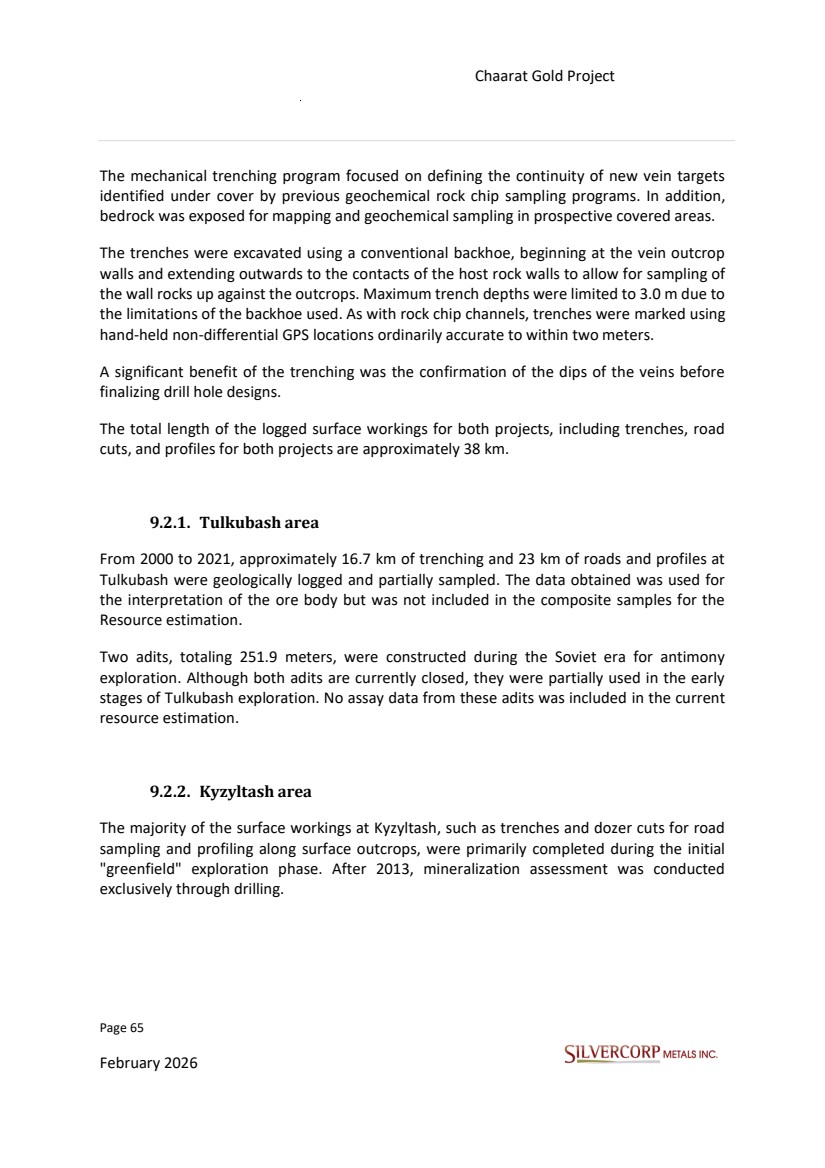
| Page 66 February 2026 Chaarat Gold Project Chatkal district, Kyrgyzstan NI 43-101 Technical Report Mineral Resource Update In 2022, additional trenching was carried out to the northeast of Kyzyltash. The purpose of this was to create surface intersections of the mineralized zones and investigate a potential northeast extension of the zones. Figure 9.1: Chaarat Gold Project, Satellite image, Google Earth 02/2026. |
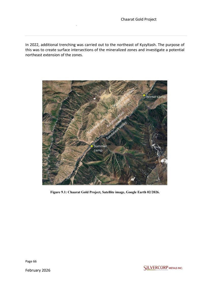
| Page 67 February 2026 Chaarat Gold Project Chatkal district, Kyrgyzstan NI 43-101 Technical Report Mineral Resource Update Figure 9.2: Surface trenching across the Chaarat Gold project area. |
| Page 68 February 2026 Chaarat Gold Project Chatkal district, Kyrgyzstan NI 43-101 Technical Report Mineral Resource Update Figure 9.3: Kyzyltash Contact Zone adit 4, total length approximately 2.1km 9.3. EXPLORATION POTENTIAL The Chaarat Gold Project is a promising advanced gold project with significant potential for mineral resource expansion. However, what makes this project even more exciting is the untapped potential it offers. Below are the high-potential areas within the Chaarat Gold Project. Looking ahead, the Tulkubash zone offers exciting exploration possibilities, with the potential to match the scale of resources already known. Recent exploration and data collection have successfully outlined oxidized gold mineralization of the Tulkubash type. Interpretation of the deposit scale geology, combined with drilling and surface sampling efforts have identified probable extension zones of the Tulkubash deposit and style of mineralisation towards the |
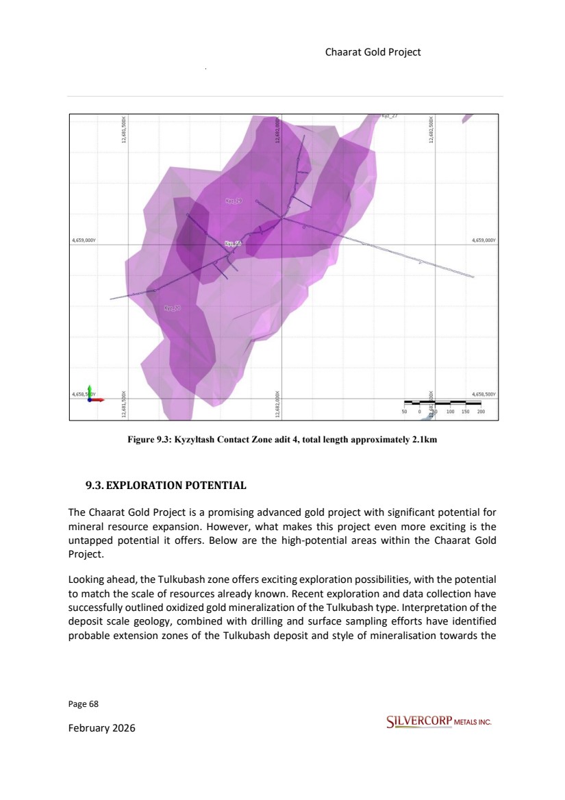
| Page 69 February 2026 Chaarat Gold Project Chatkal district, Kyrgyzstan NI 43-101 Technical Report Mineral Resource Update NE of the Tulkubash deposit. These likely extension zones are referred to as the Karator deposit and Ishakuldy target respectively. Figure 9.4: Location of the Karator and Ishakuldy exploration targets in relation to the main Tulkubash and Kyzyltash deposits. Source: Figure derived from Chaarat Gold Project by Mr. Dimitar Lazarov Dimitrov MAIG, “Kyzyltash Gold Project Mineral Resource Update, CHAARAT ZAAV CJSC, Date: October 15th, 2024” |
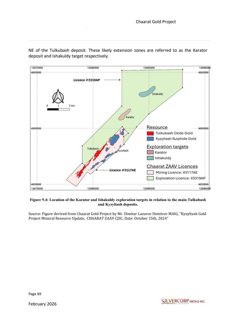
| Page 70 February 2026 Chaarat Gold Project Chatkal district, Kyrgyzstan NI 43-101 Technical Report Mineral Resource Update 10. DRILLING 10.1. INTRODUCTION Drilling the various mineralized zones that comprise the Chaarat Gold Project was conducted in drilling campaignsfrom 2000 to 2021. The current updated resource estimation utilizes 711 holes for a total of 100,790m for Tulkubash and 384 holes for a total of 78,735m for Kyzyltash. 10.2. DRILLING METHODS AND PROCEDURES The current updated mineral resource estimate utilizes 1,074 diamond drill holes (DDH) and 21 air reverse circulation (RC) holes which were drilled between 2000 and 2021 by the previous project owner (Chaarat Gold Holdings) (Table 10.1 and Figure 10.1). Diamond core drilling was primarily conducted using HQ-sized (inside diameter, 63.5mm) boreholes; however, in areas with poor ground conditions, the size was reduced to NQ (inside diameter, 47.6mm). In zones with low core recovery, particularly where Quaternary overburden was loose and unstable, a triple-tube drilling method was employed. Reverse Circulation (RC) drilling was also utilized, creating a borehole diameter of 124 mm. Various contractors, supplemented by Chaarat ZAAV-owned equipment carried out the drilling campaigns for the entire Chaarat Project. At Kyzyltash, 16 PQ sized holes (inside diameter, 85mm) were drilled for metallurgical testing. “The field activities carried out in 2021, were supervised by Dimitar Dimitrov as Senior VP Exploration at Chaarat Gold Holdings. Dimitar Dimitrov as Competent Person (CP) visited the field site operations several times during the season, last visit was between 25.08.2021 to 05.09.2021 aiming to guarantee that the implemented procedures, and the obtained data were meeting the best industry standards.” The drilling was usually carried out by local companies with experience operating in Central Asia, which included companies such as “Stalker Drilling Company”, “BJ Drilling”. |
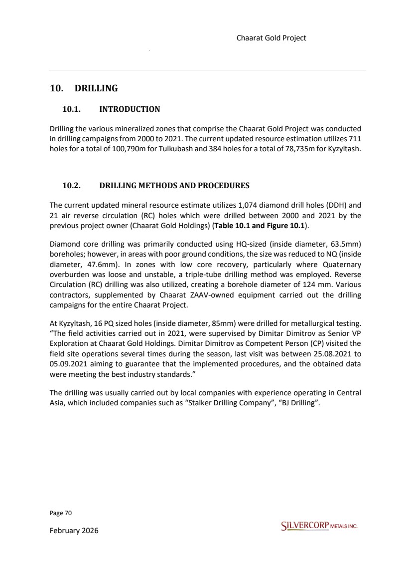
| Page 71 February 2026 Chaarat Gold Project Chatkal district, Kyrgyzstan NI 43-101 Technical Report Mineral Resource Update Table 10.1: Drilling metres by year for Tulkubash and Kyzyltash. Figure 10.1: Plan map showing location of drill holes by year for Tulkubash and Kyzyltash deposits. Year Domain # of holes meter Used for MRE # of holes meter Used for MRE # of holes meter Used for MRE # of holes meter Used for MRE # of holes meter Used for MRE # of holes meter Used for MRE # of holes meter Used for MRE # of holes meter Used for MRE # of holes meter Used for MRE Tulkubash 1 151 Y 5 1130 Y 1 2 2375 Y 5 803 Y 3 7 4272 Y 128 15984 Y Kyzyltash 7 1803 Y 5 857 Y 3 3 6677 Y 2 2 4577 Y 2 2 4577 Y 6 9 15745 Y 2 1 4804 Y 2 8 5597 Y 4 4 13344 Y Sub Total 7 1803 5 857 34 6828 27 5707 34 6952 69 15745 26 5607 65 9869 172 29328 Year Domain # of holes meter Used for MRE # of holes meter Used for MRE # of holes meter Used for MRE # of holes meter Used for MRE # of holes meter Used for MRE # of holes meter Used for MRE # of holes meter Used for MRE # of holes meter Used for MRE # of holes meter Used for MRE Tulkubash 3 9 6842 Y 1 4 1781 Y 4 7 5760 Y 1 2 1186 Y 132 17307 Y 122 19935 Y 124 19257 Y 2 1 2434 Y 2 4 2760 Y 723 101977 Kyzyltash 2 5 2745 Y 7 4 11060 Y 1 6 3508 Y 366 75294 Sub Total 64 9587 88 12841 47 5760 12 1186 132 17307 122 19935 124 19257 21 2434 40 6268 1089 177271 2000 2004 Total # of Holes Total Meters 2021 2009 2010 2011 2012 2013 2014 2016 2017 2018 2005 2006 2007 2008 2019 2020 |
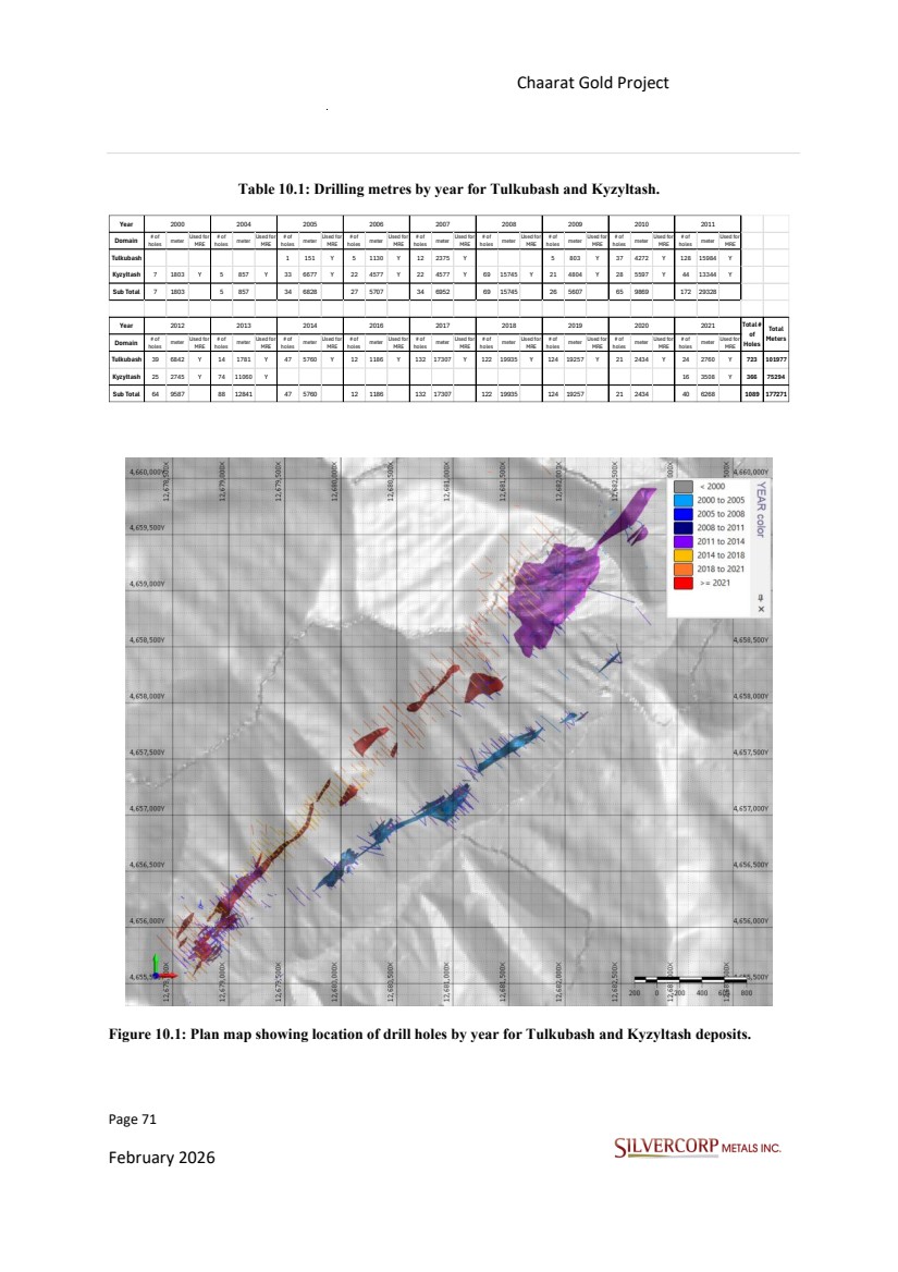
| Page 72 February 2026 Chaarat Gold Project Chatkal district, Kyrgyzstan NI 43-101 Technical Report Mineral Resource Update The holes are generally shallow, ranging from 10 m to 552 m in length, averaging 164m in length for Kyzyltash and Tulkubash. Nearly all holes were drilled at azimuths that were perpendicular to the strikes of mineralized structures and at inclinations of -90° to +53°, depending on the condition of the steep relief of the topography, mainly in the Tulkubash area. 10.3. COLLAR SURVEYS Drill hole collar locations were established before drilling using differential GPS equipment. Drill hole azimuths were set by Chaarat ZAAV geologists using a Brunton compass with a positive (+5) degrees magnetic declination is used in the project area to place wooden foresight and back-sight stakes for drill rig alignment. After level set-up of the drills at the correct drill hole azimuths, drill hole inclinations were set using a Brunton compass clinometer. The Project geodetic standard is the Pulkovo 1942 datum with a Gauss-Krüger projection, consistent with Kyrgyzstan governmental databases. Conversions are supported by commercial GIS packages. All Project location data is in meters. Surface and underground drill collars were surveyed by total station, with reported accuracies within the centimeter range. When the drill rig and casing were removed from the site, the hole was immediately marked by placing a white four-inch diameter PVC or iron pipe into each collar to preserve its location and marked with a permanent marker to record the hole number. The collar survey was done internally by members of the Chaarat ZAAV team, headed by professional surveyors, using Leica Total Station (centimeter accuracy). The downhole survey was done by the drillers after 25 - 50m intervals, using REFLEX EZ SHOT tool. 10.4. TOPOGRAPHY The Chaarat Property is set within a landscape of extreme elevation changes. The property encompasses the Sandalash valley, which lies at an altitude of approximately 2100m above sea level. This valley, measuring 100 to 300m in width, is flanked by steep slopes that ascend to surrounding ridges with peaks as high as 3600m. |
| Page 73 February 2026 Chaarat Gold Project Chatkal district, Kyrgyzstan NI 43-101 Technical Report Mineral Resource Update Satellite-derived regional topography shows significant variance (up to 50 m) from survey data. The Mineral Resource area was therefore resurveyed by total station along roads, ridges, valleys, and supplementary traverses. A new contoured surface was generated from these points. The resulting topographic surface aligns well with surveyed drill hole collars, trench, and road locations and to have an accuracy of approximately 5 meters in the vicinity of most drill holes. Towards the northern part of Tulkubash area, elevations with differences greater than 10m with respect to the topography used for the resource estimation update were identified. This was discussed with the Chaarat ZAAV geology team by email and will be pending a new topographic update. In general, the topography is acceptable for the work carried out at this exploration stage. However, the entire topography must be adjusted to have better precision with contour lines at 2.5 m according to the type of deposit of the Tulkubash area. 10.5. DOWNHOLE SURVEYS All diamond drill holes have been surveyed downhole. The preferred instrument is the Reflex EZ-shot™ electronic single-shot tool, while the RC drill hole survey data was collected with an Auslog DLS W450 tool. Historically, various other digital and non-digital instruments were also used. Downhole survey measurements for all surface and underground boreholes are typically taken at 15 m and subsequently at 50 m intervals. The geodetic framework for the Kyzyltash project is the Pulkovo 1942 datum in a Zone 12 projection. All drill collars were surveyed by qualified personnel, most recently with Leica Geosystem™ instrumentation achieving centimeter scale accuracy. A magnetic declination of +5 degrees has been applied to the project geographic data. The Reflex EZ-shot™ and Auslog DLS W450 tool is unaffected by a magnetic field because it measures the earth's angular velocity projection on its rotation axis. These measurements were made together with the progress of the perforation to detect any deviation error early. However, in many cases, data collection was carried out at the end of the drilling while the bar train was being dismantled. At this point, intervals with significant deviations in azimuth and dip were discussed with the Chaarat ZAAV geology team via email. These intervals were excluded from the well as they did not correspond with the previous and subsequent contiguous measurements of the drill hole, “Kyzyltash_Tulkubash_Database__2005_2023_17102023_final(updated_DV)corrected length_survey.xlsx” |
| Page 74 February 2026 Chaarat Gold Project Chatkal district, Kyrgyzstan NI 43-101 Technical Report Mineral Resource Update 10.6. SITE SAMPLING, PREPARATION METHODS, AND QUALITY CONTROL FOR DRILL CORE From 2018 to 2021, the sampling programs employed the following general methodologies: • All cores were routinely photographed before logging and data capture. • Geotechnical data collected by qualified technicians included core recovery, RQD, and types of discontinuities at core sampling intervals. Drill core samples have a minimum of 0.45 m and average of 1.5 m in length. • Logging was performed by trained and qualified personnel who recorded geological data such as lithology, alteration, mineralization, and structure. Drill core sampling was collected under Chaarat ZAAV geologists' supervision for determining and marking the interval to be sampled, whereby sample selection was based on geological parameters. The geologist determines the sample cut line in such a way that intends to result in both halves of the core to be equally representative of the mineralization. Figure 10.2: Core logging and data capture. Source: Figure derived and modified from Chaarat Gold Project by Mr. Dimitar Lazarov Dimitrov MAIG, “Kyzyltash Gold Project Mineral Resource Update, CHAARAT ZAAV CJSC, Date: October 15th, 2024”. |
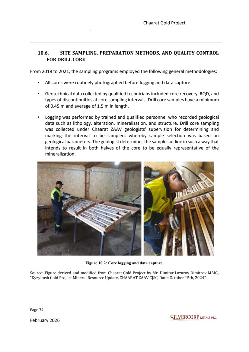
| Page 75 February 2026 Chaarat Gold Project Chatkal district, Kyrgyzstan NI 43-101 Technical Report Mineral Resource Update • All data collected through the logging procedures have been captured digitally. • The HQ drill core is marked up before being cut in the sample preparation laboratory and cut in half using a circular blade rock saw with a diamond blade cooled with water. In the case of intensely fractured zones, samples are taken with a trowel. • The samples are placed in a plastic bag and identified by a label with codes of the core sample and sampling interval. The other half is transferred to wooden boxes for storage. Figure 10.3: Core cutting and sample preparation in the core logging facility at the project site. Source: Figure derived and modified from Chaarat Gold Project by Mr. Dimitar Lazarov Dimitrov MAIG, “Kyzyltash Gold Project Mineral Resource Update, CHAARAT ZAAV CJSC, Date: October 15th, 2024”. • Standards, blanks, pulp and coarse duplicates, field duplicates and external controls were inserted after the core was cut at the logging facility. The QA/QC samples accounted for 15 - 30 % of analysed samples. • Half core is packed in a labelled polyethylene bag, weighed, and transported to the “Stewart Assay and Environmental Laboratory” (SAEL) located in Karla Balta. • “Rock density measurements are carried out using field Archimedes’ principal approach with wax. Density sampling in the last drilling campaign was designed to take |
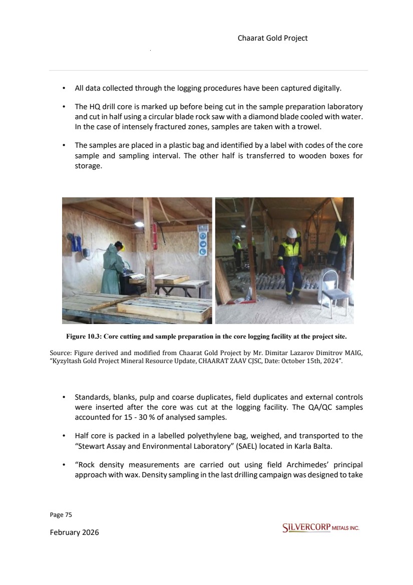
| Page 76 February 2026 Chaarat Gold Project Chatkal district, Kyrgyzstan NI 43-101 Technical Report Mineral Resource Update 1 sample (approx. 10 cm) for each 5 meters. Earlier the approach was 1 sample every 20 meters. Density sampling was not conducted in areas of intensely fractured core.” • The remaining core is stored at the designated core shed. 10.7. SAMPLE SECURITY AND CHAIN OF CUSTODY Project logistics staff manage the transport of all samples. Initially, samples are collected and delivered directly to the assay laboratory (All the samples were pre-processed and assayed at the internationally certified Kara Balta, Kyrgyzstan laboratory facility which had different owners and management throughout the years (e.g. “Information Research Center LTD”, “The Central Scientific Research Laboratory”, Alex Stewart Assay and Environmental Laboratories LTD). After 2019 the laboratory is headed by “Steward Assay and Environmental Laboratories LLC”). Core boxes are collected separately and moved to the core storage facility in Bishkek (Malovodnoye core shed). Following analysis, the logistics team retrieves the samples from the lab and transports them to the same storage facility. A continuous chain of custody is maintained by Chaarat ZAAV staff. Samples are under their direct control from the drill site to the laboratory, and from the laboratory to the final storage location, ensuring sample integrity. 10.8. GEOLOGICAL AND GEOTECHNICAL LOGGING Diamond Core Logging Procedure • Personnel: Logging is performed by Chaarat ZAAV geologists or supervised sub-contractors. • Handling: Core is transported daily from the rig to the logging facility in covered wooden trays. It is inspected at the rig site prior to transport. • Logged Parameters: A comprehensive suite of data is recorded, including lithology, alteration, oxidation, veining, mineralization, structures, hardness, fracture density, core recovery, and Rock-Quality Designation (RQD). • Data Capture: o Logging is done electronically using AGR™ 4.0 software with standardized codes. o Nominal logging interval is 1.5 m, and shortened where geologically necessary. o All core is photographed while wet, and the images are stored in the project database. |
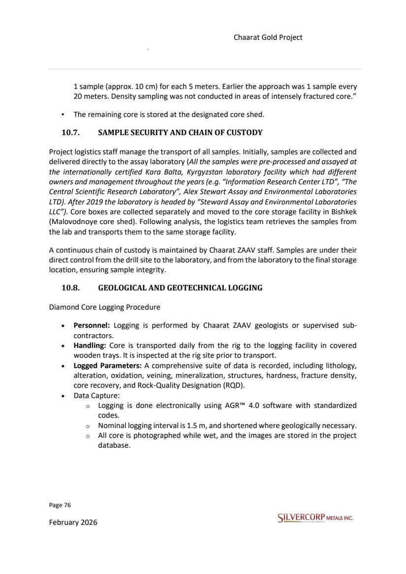
| Page 77 February 2026 Chaarat Gold Project Chatkal district, Kyrgyzstan NI 43-101 Technical Report Mineral Resource Update • Ancillary Tools: A portable Niton™ XRF analyzer is occasionally used to aid geological interpretation, but its data is explicitly excluded from grade interpolation and wireframe modelling for the Mineral Resource Estimate. RC Chip Sampling and Logging • Sample Collection: Rock chips are collected in 1-meter intervals. • Splitting: Samples are processed through a rifle splitter to create a ~8 kg sample and a duplicate. • Logging: The duplicate sample is used for logging and photography, recording lithology, alteration type and intensity, degree of disturbance, mineralization, silicification, and oxidation. Data Management & Recommendations from the past • Both graphical and descriptive logs are maintained. • Some data points (alteration, fracture density, etc.) are recorded electronically from assay sheets into the database. • It was recommended by GSI to enhance the digital capture of all geological, geotechnical, and geo-metallurgical data. |
| Page 78 February 2026 Chaarat Gold Project Chatkal district, Kyrgyzstan NI 43-101 Technical Report Mineral Resource Update Figure 10.4: Cores are numbered, ordered, and stored in a well maintained, dry and clean core shed. Source: SVM site visit photographs, 12/09/2025. Geotechnical logging was done after Bieniawski (1989) RMR system. For hardiness a S1_R6 - Descriptive approach of Soil / Rock strength estimation, based on IRSM classification. According to the protocol (GT_V1_Manual.pptx) designed prior to 2021, GT drilling aims to guide the workflow (without geochemical analysis). Other comments related to the previous protocol, the ordinary geological logging (infill, exploration holes) basically includes: lithology, hydrothermal alteration, oxidation stage, degree of fracturing, mineralization, structures, RQD, core recovery. The oxidation stage was descriptive in nature based on the intensity of the iron oxides and hydroxides in the matrix and structures following several categories: No Ox (0-5%), Weak Ox (5-20%), Moderate (20-40%), High (>40). |
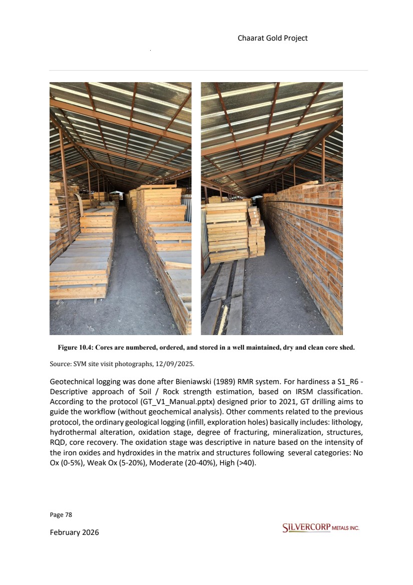
| Page 79 February 2026 Chaarat Gold Project Chatkal district, Kyrgyzstan NI 43-101 Technical Report Mineral Resource Update The geologists of Chaarat ZAAV have developed logging procedures that have been continuously improved and subjected to external audits that have confirmed that the processes implemented, and their results have a good level of certainty. The units described within the Chaarat Gold Project are summarized below. Figure 10.5: Summary of geological codes implemented for drill core logging. Source: Chaarat ZAAV 11/09/2025. |
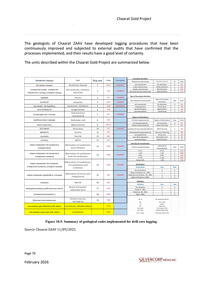
| Page 80 February 2026 Chaarat Gold Project Chatkal district, Kyrgyzstan NI 43-101 Technical Report Mineral Resource Update The QP considers the geological logging procedure (involving lithology, alteration, mineralization, and structure), and the current log sheet design to be suitable for the type of deposit. 10.9. CORE RECOVERY AND GEOTECHNICAL HOLES The average core recovery for diamond drill holes in Tulkubash and Kyzyltash is more than 97%, and between 12% and 19% for RQD. The low RQD is associated with intensely fractured, faulted, and weathered material. Table 10.2: Summary list of geotechnical holes drilled in the Tulkubash area. HOLEID COLLARX COLLARY COLLARZ LENGTH YEAR AZI DIP GD21T001 12679161 4656307 2564 99.80 2021 130 -60 GD21T002 12678964 4656365 5645 100.00 2021 315 -60 GD21T003 12679265 4656538 2610 100.00 2021 0 -60 GD21T004 12679354 4656589 2606 100.10 2021 85 -60 GD21T005 12678882 4656190 2598 150.00 2021 315 -60 GD21T006 12678727 4656011 2615 200.00 2021 135 -60 GD21T007 12678725 4656012 2615 100.00 2021 315 -60 GD21T008 12678583 4655956 2665 100.00 2021 315 -60 GD21T009 12678892 4656041 2526 200.00 2021 135 -60 GD21T010 12678632 4655779 2571 100.00 2021 280 -55 GD21T011 12679724 4657088 2779 100.00 2021 285 -60 GD21T012 12679789 4657163 2794 100.00 2021 347 -60 GD21T013 12679648 4656840 2798 100.30 2021 280 -60 |
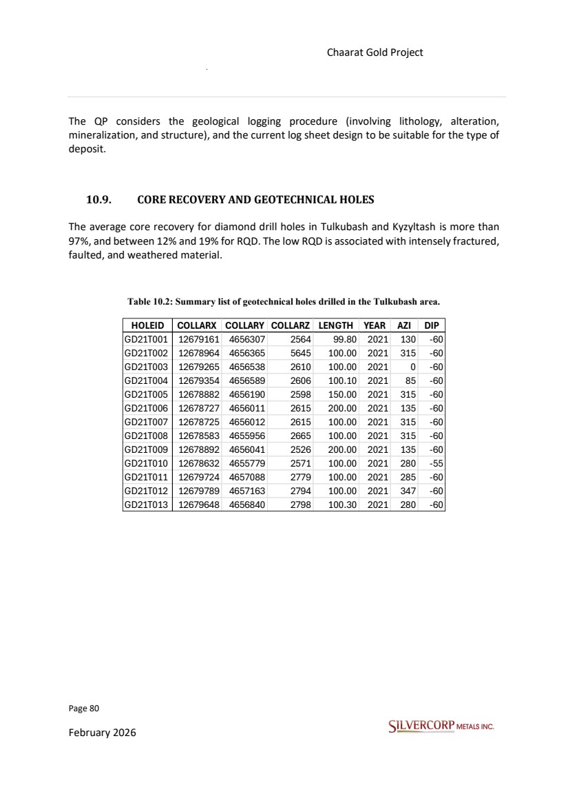
| Page 81 February 2026 Chaarat Gold Project Chatkal district, Kyrgyzstan NI 43-101 Technical Report Mineral Resource Update Figure 10.6: Plan view of geotechnical holes listed in Table 10.2 within the Tulkubash area. The statistical analysis of the previous graphs is based on drill holes used for the resource estimation in this report. Therefore, the core recoveries for Chaarat Gold Project are considered good, mainly in those intervals located near the mineralized structures. The QP believes that core drilling should always employ an HQ3 triple tube configuration to provide maximum recovery, primarily of the mineralized structures to ensure the representative nature of the samples. |
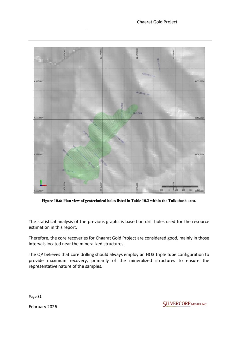
| Page 82 February 2026 Chaarat Gold Project Chatkal district, Kyrgyzstan NI 43-101 Technical Report Mineral Resource Update The QP believes that the RQD, as one of many geotechnical measures, will help monitoring and predicting future development of open pit and underground mine designs. 10.10. DRILLING RESULTS In the Tulkubash area, 100,790 m of drilling was carried out in 711 drill holes, and in the Kyzyltash area, 78,735 m of drilling was carried out in 384 drill holes. A total of 179,525 m in 1095 drill holes from 2000 to 2021. All this data corresponds to the final declared holes from Chaarat Gold Holdings Limited for this report. A 2004 geochemical survey identified significant gold anomalies, with values exceeding 1 g/t over a 4 km strike length and a peak of 73 g/t. These anomalies, ranging from 100 m to 800 m in length and 50 m to 150 m in width, were confirmed as the Tulkubash deposit through follow-up trenching and sampling, with positive results extending over a 10 km strike length. Subsequent drilling on a 40 m by 40 m grid, targeted the mineralized structures at optimal angles. By 2006, drilling was focused on developing the Main and Contact zone mineralization of the Kyzyltash deposit, which included the creation of an exploration adit for drill access and metallurgical sampling. Concurrently, soil sampling continued to define a large, coherent geochemical anomaly at what is now the Tulkubash deposit. An initial drill hole in this area in 2005 intersected 17.1 m at 4.61 g/t gold. Systematic drilling through 2013 defined underground Mineral Resources within nine mineralized zones along the Main and Contact zones. In 2010, metallurgical tests indicated the potential for a low-cost, open-pit, heap leach operation for Tulkubash, prompting an extensive drilling program in 2011. After a period of modest activity, exploration efforts were renewed in 2017 and 2018, focusing on Tulkubash as a potential starter mine. After 2018, exploration continued mainly in Tulkubash to confirm the continuity of mineralization. |
| Page 83 February 2026 Chaarat Gold Project Chatkal district, Kyrgyzstan NI 43-101 Technical Report Mineral Resource Update 11. SAMPLE PREPARATION, ANALYSES AND SECURITY Several independent Mineral Resource estimates and audits have been conducted on the Chaarat Gold Project since exploration began and the most recently reports by Mr. Dimitar Lazarov Dimitrov MAIG, “Kyzyltash Gold Project Mineral Resource update, date: October 15th , 2024” and “Tulkubash Gold Project Mineral Resource Estimate, date: April 2022”, including technical comments about sample preparation, analyses and security. “The field activities carried out in 2021, were supervised by Dimitar Dimitrov as Senior VP Exploration at Chaarat Gold Holdings. Dimitar Dimitrov as Competent Person (CP) visited the field site operations several times during the season, last visit was between 25.08.2021 to 05.09.2021 aiming to guarantee that the implemented procedures, and the obtained data were meeting the best industry standards.” The focus of this section’s review will be to check and validate what has been done since 2018. This section discusses the additional sampling carried out by Chaarat Gold Holdings Limited during the 2018–2021 drilling campaign. Based on discussions with Chaarat ZAAV personnel and Mr. Salamat Imanakunov, Laboratory Manager at SAEL, the QP considers that, during the site visit—including inspections at the Malovodnove core shed and at Stewart Assay and Environmental Laboratories LLC (https://www.sael.kg/kg) in Kara-Balta on September 11–12, 2025—the treatment of drill samples was conducted in accordance with high Quality Assurance/Quality Control (QA/QC) standards. |
| Page 84 February 2026 Chaarat Gold Project Chatkal district, Kyrgyzstan NI 43-101 Technical Report Mineral Resource Update Table 11.1: Laboratories used by Chaarat ZAAV. 11.1. LABORATORY SAMPLE PREPARATION, ASSAYING, AND ANALYTICAL PROCEDURES 11.1.1. Sampling Methods All samples were pre-processed and assayed at the internationally certified laboratory facility in Kara Balta, Kyrgyzstan. This facility has operated under different owners and management over the years, including "Information Research Center LTD," "The Central Scientific Research Laboratory," and "Alex Stewart Assay and Environmental Laboratories LTD." Since 2019, the laboratory has been operated by "Steward Assay and Environmental Laboratories LLC." The laboratories used for sample preparation and analysis during specific periods are as follows: • 2007 to 2014: Samples were prepared and assayed at the IRC Laboratory in Kara Balta, Kyrgyzstan. • 2017 to 2019: Samples were prepared and assayed at ALS Global (Kara Balta), with referee check samples sent to SGS Vostok Limited (Chita, Russia). • 2020 (RC drilling) and 2021: Sample campaigns were prepared and assayed by Steward Assay and Environmental Laboratories LLC (Kara Balta, Kyrgyzstan). SGS (Chita, Russia) was used as the external control laboratory for the 2021 campaign. ID notes Period IRC CSRL ALS 2008-2019 SAEL from 2019 GA external control 2004-2014 SGS external control 2018-2021 2004-2008 Location Information Research Center LTD laboratory name SGS Vostok Limited Chita, Russia Same laboratory under different names Karabalta, Kyrgyz Republic The Central Scientific Research Laboratory ALEX STEWART ASSAY AND ENVIRONMENTAL LABORATORIES LTD Stewart Assay and Environmental Laboratories LLC Genalysis Laboratory Services PTY LTD Australia |
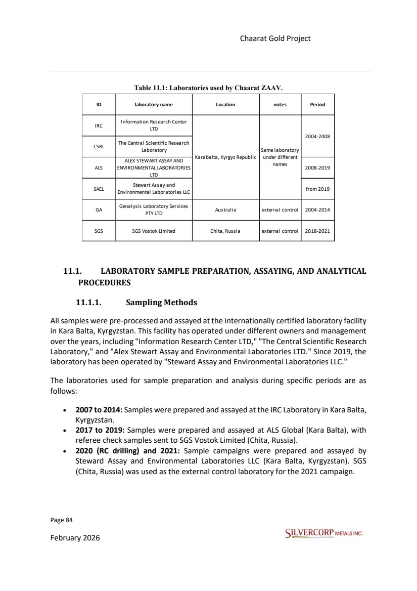
| Page 85 February 2026 Chaarat Gold Project Chatkal district, Kyrgyzstan NI 43-101 Technical Report Mineral Resource Update • Reanalysis Laboratory Services PTY LTD (Australia) and SGS Vostok Limited (Chita, Russia) have also been used for independent external control. The sample preparation process involves crushing the entire sample to 90% passing 2mm. The crushed material is then pulverized to 85% passing 0.075 mm to create two pulps. One pulp is returned to the company as a duplicate, while the second is analyzed using the methods below: • Fire assay with lead collection and an Atomic Absorption (AA) finish. • Aqua Regia digestion with an Inductively Coupled Plasma-Optical Emission Spectrometry (ICP-OES) finish. • Analysis of total sulphur, sulphide sulphur, and sulfate sulphur by chemical treatment and LECO for select samples (those with above 0.25 ppm Au). • LeachWELL analysis for certain selected samples (those with above 0.25 ppm Au). • The lower detection limit (LDL) is 0.05 ppm for gold (Au) and 1 ppm for silver (Ag). 11.1.2. Analytical and Test Laboratories Certifications and documents from Alex Stewart Assay and Environmental Laboratories LTD were delivered by Mr. Salamat Imanakunov, Laboratory Manager; -“ 22 ASTK Lab 07.pdf”, “A Proficiency Test in Association with the Production of Certified Reference Materials for ROCKLABS, December 2023”. Appendix 2. -“Accreditation Certificate 2021 KCA17025.pdf, August 2021 ”, certifying that Stewart Assay and Environmental Laboratories is accredited to perform testing according to international standards (ISO/IEC 17025:2017) and maintains a quality management system. The specific scope of their accreditation is detailed in Appendix 2. - “Accreditation Certificate 2022 KCA 17020.pdf, June 2022”, Stewart Assay is accredited as a type “A” control in accordance with international Standard IS0/IEC 17020:2012 (GOST ISO/IEC 17020-2013). Appendix 2. |
| Page 86 February 2026 Chaarat Gold Project Chatkal district, Kyrgyzstan NI 43-101 Technical Report Mineral Resource Update - “RR April 2025 - Stewart Assay and Environmental Laboratories LLC.pdf, April 2025”, Stewart Assay and Environmental LLC has participated in the April 2025, Geostats Survey of International Laboratories. Appendix 2. - “Электронный сертификат об аккредитации UKAS ICO 17025.pdf, January 2024”, Testing Laboratory No. 7491 is accredited in accordance with International Standard ISO/IEC 17025:2017- General Requirements for the competence of testing and calibration laboratories. Appendix 2. 11.1.3. Sample Preparation, Analysis and Security The following steps correspond to the normal procedure of Stewart Assay and Environmental Laboratories LCC; Sample Submission -“Samples received with barcode labels attached to sample bag” -“ Samples received without barcode labels attached” -“ Pulps received without barcode labels attached. At least one out of every 50 samples is selected at random for routine pulp QC tests (LOG-QC). For routine pulps, the specification is 85% passing a 75 micron screen. Other specifications may be checked as per client requirements.” -“ Workorder/administration fee applied per submittal” Sample Preparation Package -“ All sample preparation packages below include sample registration in the laboratory tracking system and weighing. Excessively wet samples may require additional drying .” -Drill Core, Rock and Chip Samples; - “It is very helpful to advise us of mineralized samples that may require special equipment cleaning cycles to eliminate contamination of other samples that might follow in a batch.” |
| Page 87 February 2026 Chaarat Gold Project Chatkal district, Kyrgyzstan NI 43-101 Technical Report Mineral Resource Update - “Drill core, rock and chip samples up to 3kg, are the most common; Dry, crush -2mm to >=90% or >=70%, riffle split 250g, pulverize to >=90% or >=70%, -75 micron (200 mesh). - Dry, crush -2mm to >=90% or >=70% ,riffle split 1000 g, pulverize to >=90% or >=85%, -75 micron (200 mesh). Drying -In consultation with the client, -Drying of samples in a drying oven at 105 °C, default drying procedure for most rock chip and drill samples. Pulverizing -Pulverize to -75 micron (200 mesh)>=90% or 85%, default procedure for samples that are finely crushed and split to 1kg sub samples. Precious metals analysis -Au(Au4), range 0.05 -100 ppm, Fire Assay with Atomic Absorption finish, 30g nominal sample weight, drilling campaign 2018, 2019, 2020,2021. -Ag , range 1-100 ppm, AR/ES/G, 0.2 g Aqua Regia digestion with following, ICP-OES, #35 elements, does not analyze “S”, even though some of the base metals dissolve completely for most of the geological matrices, the data obtained during the aqua -regia digestion should be considered only as representing the leachable part of the specific element being analyzed, drilling campaign 2018, 2019, 2020, 2021. The rest of the elements are analyzed by Aqua Regia, with the below listed detection limits. |
| Page 88 February 2026 Chaarat Gold Project Chatkal district, Kyrgyzstan NI 43-101 Technical Report Mineral Resource Update Figure 11.1: Detection limits for the suite of elements commonly analysed for via Aqua Regia. Source: SAEL pricing list, https://sael.kg/cb/pricelist.pdf - Total Sulphur by Leco analyzer, Analysis SE/S1, range LDL 0.01%, drilling campaign 2018, 2019. - Stotal + Ssulphide + Ssulphate by LECO after chemical treatment, range 0.01%-50%, SE/S5, “Stotal”, “Ssulphide”, “Ssulphate”, drilling campaign 2020, 2021. Stewart logs the samples into the LIMS (Laboratory Information Management System), re-labels the sample packets with barcoded labels, and assays for gold by 30 g charge Fire Assay, Aqua regia digestion, and AA finish. Stewart assay values are reported electronically to Chaarat ZAAV in digital format (both spreadsheet and PDF) by the laboratory and were automatically loaded into the database after validation. |
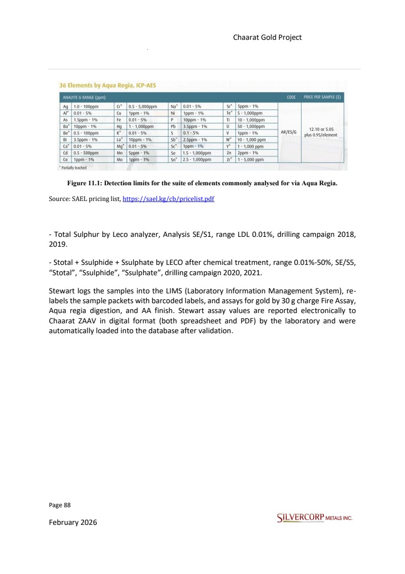
| Page 89 February 2026 Chaarat Gold Project Chatkal district, Kyrgyzstan NI 43-101 Technical Report Mineral Resource Update Figure 11.2: Sample intake, sorting, and outside storage at Stewart Analytical and Environmental Laboratories. Source: SVM site visit photographs, 14/09/2025. |
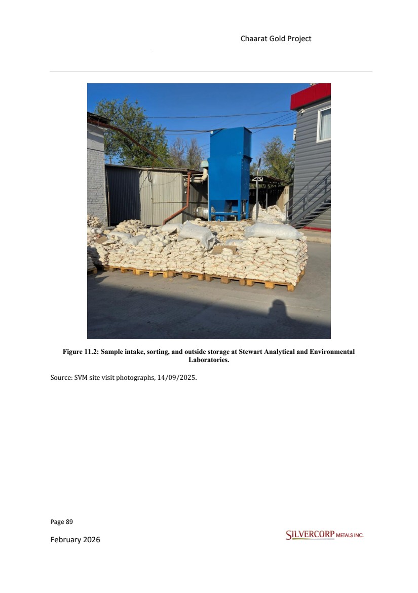
| Page 90 February 2026 Chaarat Gold Project Chatkal district, Kyrgyzstan NI 43-101 Technical Report Mineral Resource Update Figure 11.3: Sample drying at Stewart Analytical and Environmental Laboratories. Source: SVM site visit photographs, 14/09/2025. Figure 11.4: Sample crushing, splitting, and milling stations at Stewart Analytical and Environmental Laboratories. Source: SVM site visit photographs, 14/09/2025. |
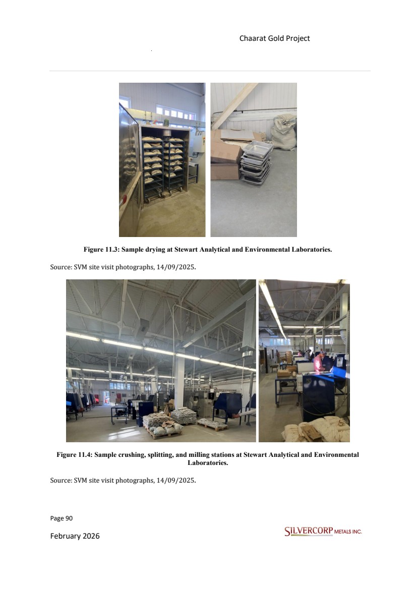
| Page 91 February 2026 Chaarat Gold Project Chatkal district, Kyrgyzstan NI 43-101 Technical Report Mineral Resource Update 11.2. STORAGE, SECURITY OF DRILL HOLE DATA, AND SAMPLE DISPATCHING All the samples from the Chaarat gold project drilling and sampling campaigns (coarse reject and pulp) have been centralized in a secured storage facility in a warehouse in the in core shed in Malovodnoye, near Bishkek. Cores are numbered, ordered, and stored in a dry, clean, well-maintained core shed. To ensure accurate assay, one half of representative core is selected and sealed within individual labelled polyethylene bags. After the bags are top-rolled and stapled, they are weighed and then consolidated into rice sacks, typically holding five to six samples each. These rice sacks are then secured with wire, clearly labelled, and prepared for transfer to the laboratory via project logistics. The unsampled half of the core is securely stored in numbered and labelled wooden core boxes, intended for archival purposes and potential follow up analysis and review. Project logistics staff are responsible for ensuring secure transport of these core boxes to the designated Chaarat project core storage facility in Bishkek. Sealed sample bags are placed in rice sacks in sequence for shipment to the lab. A record of all samples shipped is kept by the geologist in charge of sending the sample shipments. Chaarat ZAAV personnel transport samples from the project to the assay laboratory in Bishkek. The sealed bags and customized zip strips ensure the chain of custody between Chaarat ZAAV and the lab. Sample security relied upon the fact that the samples were always attended to or locked at the sample dispatch facility. Chaarat ZAAV has always undertaken sample collection and transportation. Chain of custody procedures consisted of completing sample submittal forms accompanying the sample shipment sent to the laboratory to ensure the laboratory received all samples. The QP believes that the sample storage procedures and the data security are consistent with general industry practices. 11.3. BULK DENSITY MEASUREMENTS (SPECIFIC GRAVITY) Different files for the bulk density measurements from 2018 to 2021 were reviewed and validated. |
| Page 92 February 2026 Chaarat Gold Project Chatkal district, Kyrgyzstan NI 43-101 Technical Report Mineral Resource Update Density is a measure of the mass per unit volume of a material. In the case of geological materials, Specific Gravity (SG) is the unitless ratio of the density of the sample to the density of water. At a water temperature of 4°C, the numerical value of density and SG for a given sample is equal. At any other temperature, the values are different; however, for temperatures of less than 40°C, the discrepancy is in the third or fourth decimal place and is thus well within anticipated errors of the methodology. For that reason, density in t/m3 and SG are typically used interchangeably and not reported separately. In the case of the Chaarat Gold Project, density and SG data have been collected and used as “density” results. The errors introduced are minimal and do not affect Mineral Resource estimation. The published report by GeoSystems International Inc. “Chaarat Gold Project, Republic of Kyrgyzstan, effective date report: 19 October 2014” and “Mineral Resource update Tulkubash zone, Chaarat Gold Project, Republic of Kyrgyzstan, effective date of report: 5 February, 2017, “Prior to this resource update, there was little information regarding in-situ dry density. The few samples that had been taken in the past allowed for applying global averages, 2.52 t/m3 for the waste rock (outside the interpreted zones), and 2.84 t/m3 for all material within the wireframes. More density measurements from drill holes for the entire Chaarat Gold Project were obtained during the second half of 2014, to a total of 1,052 dry density measurements available for this resource model update. Not all these density samples are available.” In summary, "dry density (WAX)" is a technique for measuring the density of a dry sample, where a wax coating is applied to the sample before submerging it in water to accurately determine its volume without water absorption or material loss. This method is particularly useful for samples that are difficult to measure directly due to their porosity, friability, or irregular shape. For this report, 1,056 new dry density measurements from 2017, 2018, and 2019 have been added. The dry bulk density for these samples, and others, was obtained using the paraffin-coated immersion (Archimedes) method, which allows for the calculation of specific gravity (SG). The complete dataset now comprises 2,108 dry density measurements. |
| Page 93 February 2026 Chaarat Gold Project Chatkal district, Kyrgyzstan NI 43-101 Technical Report Mineral Resource Update Figure 11.5: Specific gravity measurements of core samples from Kyzyltash in 2021. Source: Figure derived from Chaarat Gold Holdings Ltd. By Mr. Dimitar Lazarov Dimitrov MAIG, “Kyzyltash Gold Project Mineral Resource update, date: October 15th, 2024”. |
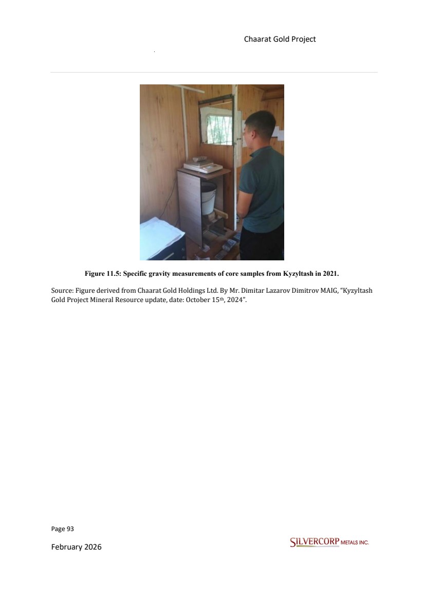
| Page 94 February 2026 Chaarat Gold Project Chatkal district, Kyrgyzstan NI 43-101 Technical Report Mineral Resource Update Figure 11.6: Density t/m3 |
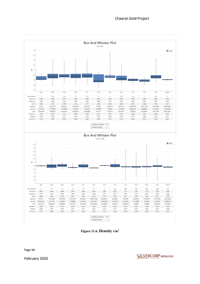
| Page 95 February 2026 Chaarat Gold Project Chatkal district, Kyrgyzstan NI 43-101 Technical Report Mineral Resource Update Figure 11.7: Density t/m3 by year. 11.4. QUALITY ASSURANCE-QUALITY CONTROL PROCEDURES Different QA/QC program files from 2018 to 2021 were reviewed and validated. Silvercorp continues employing the same practices and improvements that were detailed in previous reports, which align with industry-standard exploration sampling methodologies, procedures, and techniques. All geochemical rock and drill samples are collected under the supervision of the company’s geologists. Geochemical assays are obtained and reported under a quality assurance and quality control (QA/QC) program. A robust Quality Assurance/Quality Control (QA/QC) program has taken place during the exploration and operational activities between 2005 and 2021. The program from 2018 to 2021 is supported by a well-organized dataset of over 10,000 QA/QC samples covering all areas across the property. The integrity of both drilling and surface sample data has been |
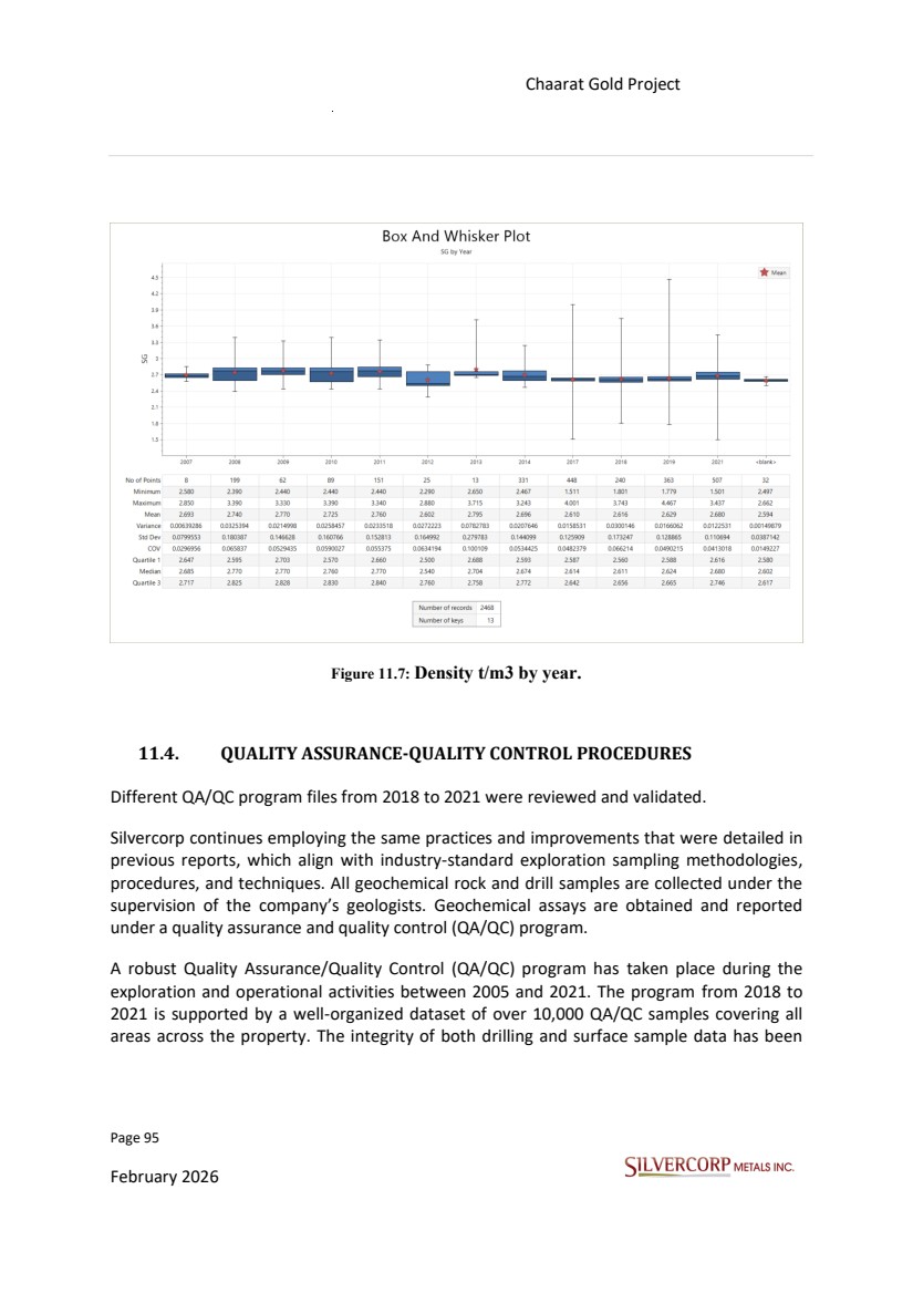
| Page 96 February 2026 Chaarat Gold Project Chatkal district, Kyrgyzstan NI 43-101 Technical Report Mineral Resource Update systematically monitored through a suite of QA/QC procedures, including the analysis of certified reference materials (CRMs), blanks, pulp duplicates, coarse duplicates, and field duplicates (introduced in 2021). Further validation is achieved via check-assaying at accredited, independent laboratories. Although the QA/QC scheme has been refined over time, control samples currently represent approximately between 15 to 30 % of all samples assayed for drilling campaigns from 2018 to 2021. Protocols Chaarat ZAAV presents a percentage of control sample insertion rates in surface samples, Protocol_Chaarat_Drilling 2018.docx and Protocol_Chaarat_Drilling 2019.docx “One in 20 reject samples will be retagged and sent back to the lab as a coarse duplicate check”. A summary of insertion rates from 2018 to 2021 for core drill samples is presented in Table 11.2. Table 11.2: Distribution of control samples per year as a percentage of total samples. The number of samples for each assay batch at the lab is ±40-80 samples for Fire Assay with Atomic Absorption, and each has its respective control samples to ensure the validity of the precision, accuracy, and degree of contamination in each analysis requirement. Chaarat ZAAV, through a process of continuous improvement, has been optimizing and adjusting the QC program. A constant and proactive evaluation of the results is carried out through graphs and statistics that determine the percentages of errors in the results of the sample value (monthly and yearly reports). During the 2018 to 2021 drilling campaigns, twelve CRMs were used (Table 11.3) repeating the standard certificate at least 37 times (OxH163) and at most 584 times (OxD127), covering various Au grades. These materials were purchased from Rocklabs, a Division of Scott (www.rocklabs.com), Auckland, New Zealand. Sample Type 2018 20019 2020 2021 Parameters CRMs 7% 7% 7% 8% Accuracy Field Duplicates 5% Coarse Duplicates 7% 8% 6% Pulp Duplicates 4% 8% 6% Blanks 5% 8% 7% 2% Contamination Precision |
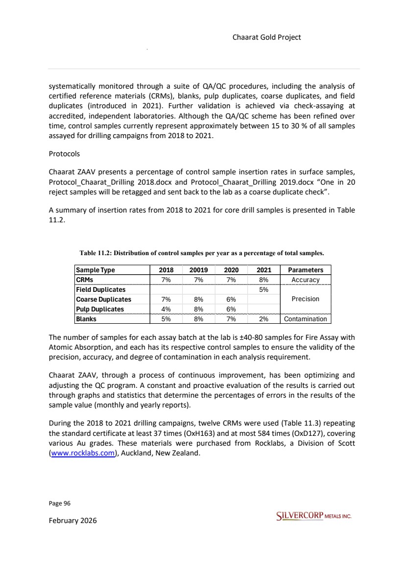
| Page 97 February 2026 Chaarat Gold Project Chatkal district, Kyrgyzstan NI 43-101 Technical Report Mineral Resource Update Table 11.3 summarizes the expected gold values according to the different Rocklabs certificates and analysis results such as comparison average, Mean Bias, RSD, 95% Confidence interval for average, ± 3 Std. Dev, from the controls performed by Chaarat ZAAV between 2018 and 2021. Rocklabs Note for all CRMs: Neither the Standard deviation nor the Confidence interval should be used as a basis to set control limits when plotting individual laboratory results". Table 11.3 List of CRMs used Figure 11.8: Box and whisker plot with base statistics for the CRM’s results. CRM OxD151 OxD127 SE86 OXF142 OxH139 OxH149 OxF162 SJ111 SN106 OxH163 OxD157 OxF165 Element (ppm) A u A u A u A u A u A u A u A u A u A u A u A u Expected Value 0.430 0.459 0.595 0.805 1.312 1.279 0.832 2.812 8.461 1.313 0.399 0.857 +2 Std. Dev 0.448 0.483 0.625 0.743 1.360 1.349 0.886 2.948 8.771 1.365 0.423 0.891 -2 Std. Dev 0.412 0.435 0.565 0.767 1.264 1.209 0.778 2.676 8.151 1.261 0.375 0.823 +3 Std. Dev 0.457 0.495 0.640 0.862 1.384 1.384 0.913 3.012 8.926 1.391 0.435 0.908 -3 Std. Dev 0.403 0.423 0.550 0.748 1.240 1.174 0.751 2.608 7.996 1.235 0.363 0.806 Rocklabs Standards |
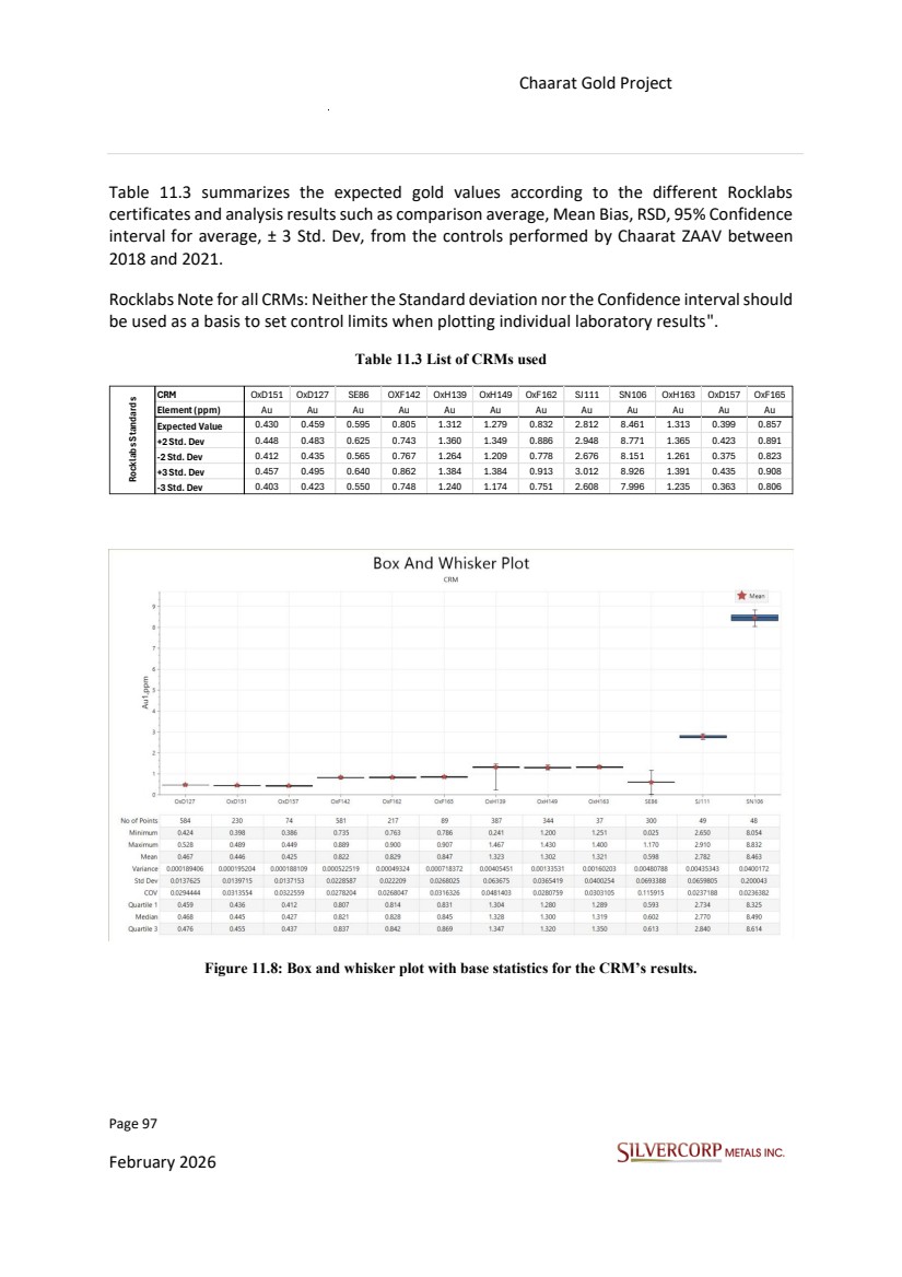
| Page 98 February 2026 Chaarat Gold Project Chatkal district, Kyrgyzstan NI 43-101 Technical Report Mineral Resource Update Standards and blanks are inserted randomly after every 20 samples of drill core batches submitted to the laboratory, while duplicates are made on the coarse reject and pulps, blanks, and field duplicates from 2021 (Kyzyltash met drill holes). The company submits Blank Materials (with values below the detection limit) to monitor sample preparation contamination and laboratory sample sequencing. Blanks can be coarse or pulverized, ideally reflecting the analyzed sample type. Documenting provenance, mesh size and mass of blanks assists in evaluating assays, especially if blanks change throughout the project. The performance of the blank samples remains consistently strong, as in previous campaigns. This is largely attributable to the use of limestone as blank material, the ease with which this material is recognized in the preparation laboratory, and the special care taken to clean equipment prior to processing the blanks. As noted above, it is recommended that Silvercorp introduce blank material that is less easily identifiable into the sample stream to more rigorously verify blank performance. Roughly 133 blank material samples (unaltered, barren sediments from the area) were used within the 2021 drilling QAQC procedure. Only one sample showed low gold anomaly, increasing above the detection limit. It is considered that this is related to blank material natural anomaly instead of laboratory issues. The overall blank results confirm lack of any systematic sample contamination. Source: Chaarat Gold Holdings Ltd. By Mr. Dimitar Lazarov Dimitrov MAIG, “Kyzyltash Gold Project Mineral Resource update, date: October 15th, 2024”. As a routine part of their QA/QC program, Chaarat ZAAV randomly selected Check-Samples from holes drilled in 2020 and 2021 for independent external control of the pulps generated by their primary commercial lab (SAEL) and sent them to an umpire lab for check assay purposes which were analyzed by Renalysis Laboratory Services PTY LTD (Australia) and SGS Vostok Limited (Chita, Russia).. The QP reviewed and validated the results obtained in Chaarat Gold Project’s 2018 to 2021 drilling campaigns and defined the following sample acceptance criteria following industry standards. These are: Accuracy The Bias is the deviation or difference of the results obtained concerning the value accepted as a reference or true value. It allows to estimate the accuracy and represents the systematic error. |
| Page 99 February 2026 Chaarat Gold Project Chatkal district, Kyrgyzstan NI 43-101 Technical Report Mineral Resource Update Mean Bias < 5%: Good Mean Bias 5%-10%: Acceptable Mean Bias >10%: Unacceptable 1. Precision The precision evaluation in the analysis requirements must be verified daily, and all the results of the control samples for the precision evaluation must be within acceptable limits. It is accepted that only 10% of the total samples must be above the Error Line (EL), the maximum conventional error line. Samples above the EL are considered Failed Samples (FS). If a failed sample is found in all the elements analyzed, the laboratory must be notified immediately to take corrective measures. Global or Mean Relative Error (MER) must be below the following ranges to be considered acceptable duplicate values: Field Duplicates ≤ 35% Coarse Duplicates ≤ 25% Pulp Duplicates ≤ 15% Contamination It is used as a maximum limit for contamination, a safe line of five times the minimum detection limit (MDL). It assumes a significant level of contamination if the value of the blanks exceeds the 5 time of MDL 11.5. Results of Chaarat Gold Project, QA/QC Assessment Allstandard samples were included, even those considered Out of Control Samples (OCS) with values outside the range of ±3SD, which are not considered to calculate the bias in the results. Some examples of check graphs are shown in Figures 11.9 to 11.11, Coarse, Pulp, Field Duplicate check (Precision), and CRMs (Figure11.8, Accuracy) from 2018 to 2021. The blanks, as mentioned before, check for cross contamination during sample prep and their results are |
| Page 100 February 2026 Chaarat Gold Project Chatkal district, Kyrgyzstan NI 43-101 Technical Report Mineral Resource Update consistently acceptable (Figure 11.12). This is attributable to the use of clearly unaltered and mineralised blank materials. Check assays are performed by the secondary (umpire) laboratory on representative duplicate samples of previously analyzed pulps. There has been a strong program of check assaying at the Chaarat Gold Project, with just over 2% (2020) and 3% (2021) of all samples originally assayed at SAEL being submitted for check assaysto SGS. The results show very good assay accuracy between laboratories, with R square 0.99, and standard error less than 0.23 for gold relative to the original results. Field duplicates were collected during the 2021 drilling campaign with no field duplicates collected for the 2018 to 2020 drilling campaigns. Only coarse and pulp duplicate control samples were inserted for the 2018 to 2020 programs. The QP believes that the collection of field duplicates, for precision control, should be prioritized in these exploratory stages. If they are carefully collected and analyzed at the same laboratory by the same procedure, these splits will be able to estimate the variance contributed by the entire sample collection, preparation, and assaying process. The original and duplicate must be represented by 1/4 (HQ diameter) sawn core samples, and ½ of the remaining core must be left for backup in the wooden box. |
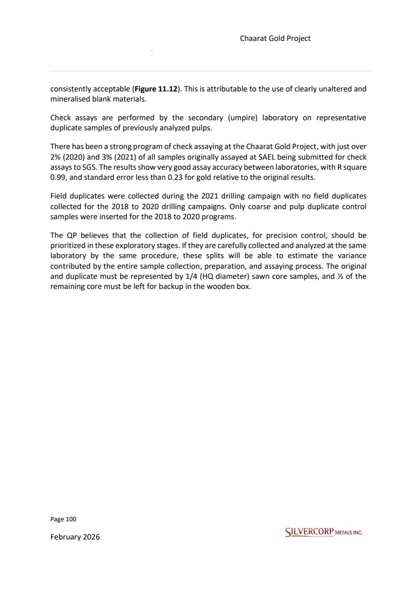
| Page 101 February 2026 Chaarat Gold Project Chatkal district, Kyrgyzstan NI 43-101 Technical Report Mineral Resource Update Figure 11.9: QAQC Program, Coarse Duplicate Results. |
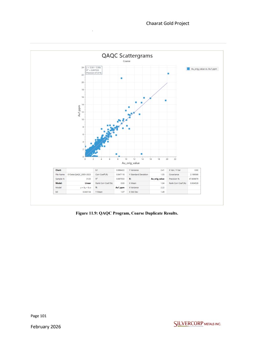
| Page 102 February 2026 Chaarat Gold Project Chatkal district, Kyrgyzstan NI 43-101 Technical Report Mineral Resource Update Figure 11.10: QAQC Program, Pulp Duplicate Results. |
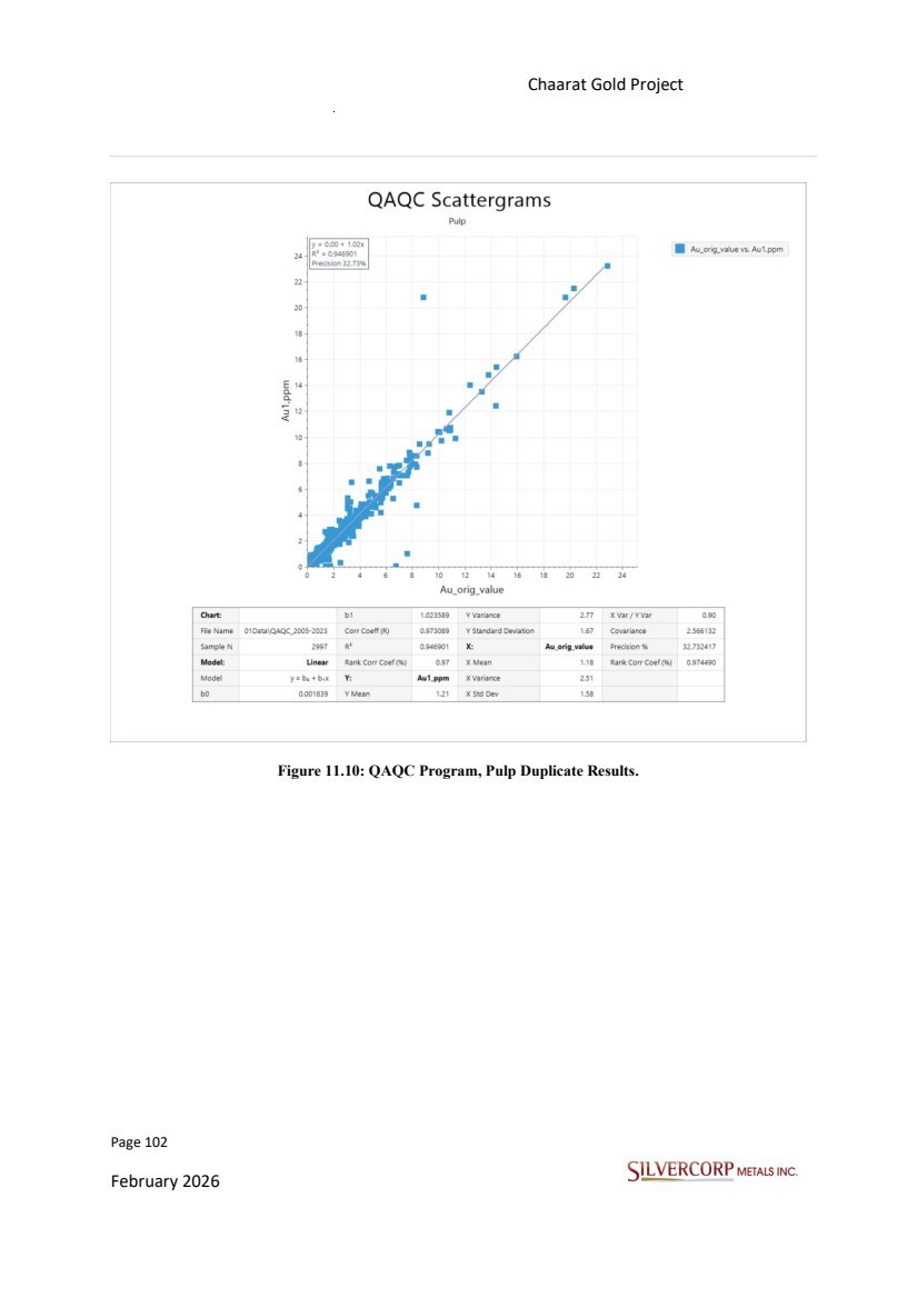
| Page 103 February 2026 Chaarat Gold Project Chatkal district, Kyrgyzstan NI 43-101 Technical Report Mineral Resource Update Figure 11.11: QAQC Program, Field Duplicate Results. |
| Page 104 February 2026 Chaarat Gold Project Chatkal district, Kyrgyzstan NI 43-101 Technical Report Mineral Resource Update Figure 11.12: QAQC Program, Blanks Results. 11.6. Conclusions The main conclusions of the QA/QC from 2018 to 2021 drilling and assaying programs are summarized below: • The accuracy of the primary laboratory is acceptable for Au. |
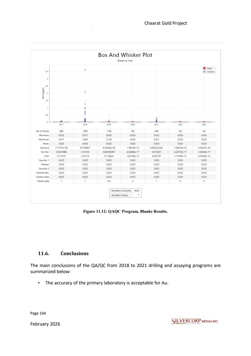
| Page 105 February 2026 Chaarat Gold Project Chatkal district, Kyrgyzstan NI 43-101 Technical Report Mineral Resource Update ✓ Chaarat ZAAV prepared control charts to assess Au accuracy in all the drilling campaigns. ✓ For all CRMs, Au biases fall into acceptable limits (≤ 5%), except the standard “OxD157<=7%, 2021” • The precision of the primary laboratory is acceptable for Au. ✓ Chaarat ZAAV prepared control charts to assess Au precision in all the drilling campaigns. ✓ For Au, the Mean Relative Error (MER %) for all duplicate types falls into acceptable limits (<15%, <25%, and <35%). • For the 2018-2021 campaigns, Chaarat ZAAV prepared graphs Au (ppm) in coarse and pulp blanks against the correlative sample numbers and assessed contamination using a threshold set at five times the minimum detection limit (MDL. Blank values exceeding 5 times of the MDL were interpreted as indicating a potentially significant level of contamination. ✓ The QP reviewed all diagrams provided by Chaarat ZAAV and found no evidence of significant contamination during the sample preparation process of the 2018-2021 drilling campaigns. • Check assays are performed by the secondary (umpire) laboratory SGS on a representative sample of previously analyzed pulps. Cross-laboratory validation with SAEL and SGS to evaluate the performance of the primary laboratory shows that the data obtained by SAEL and SGS are reliable. The comparison of the element Au is acceptable in all cases. Based on the results obtained in the QA/QC program framework, the confidence level in the assays and representative nature of the data are acceptable and can be used to support a resource estimate. The results obtained have been confirmed and/or reproduced within reasonable limits by an alternative laboratory. |
| Page 106 February 2026 Chaarat Gold Project Chatkal district, Kyrgyzstan NI 43-101 Technical Report Mineral Resource Update 12. DATA VERIFICATION The QP and members of Silvercorp’s technical and geological team inspected the drill holes both in section and plan view in Micromine, and reviewed the geological interpretation in digital format, finding an acceptable correlation with the drill hole database. The scope of the site inspection included discussions and analysis on general data acquisition procedures, sampling procedures, quality assurance/quality control (QA/QC), geology, mineralization, structural characteristics, mineral processing and metallurgical testing, mineral resource estimation, inspection of drill pads and drill hole collar locations, core storage; as well as an inspection of drill core recovery and mineralization, infrastructure and permits collected by Chaarat ZAAV. The QP and staff members of Silvercorps technical team also collected a number of samples for independent assays from several representative drill holes covering the Tulkubash oxide zone, Kyzyltash main zone, Kyzyltash contact zone, and the Karator oxide target. Additionally, the assay data returned from the various drilling campaigns are considered to be acceptable as all drilling phases were reported in new releases and internals reports by the previous project owner and published under JORC guidelines on the company’s website. These reports are considered sufficient by the QP as evidence of the presence of economic grades of mineralization. 12.1. SITE VISIT The site visit to the Chaarat Gold Properties to complete the NI 43-101 requirements was conducted from 11 September to 16 September 2025, by Alex Zhang (P.Geo), and members of Silvercorp’s geology and technical team. 12.1.1. Certificates Review The QP received original assay certificates in CSV and PDF formats for samples collected during the 2018 to 2021 field seasons. A random manual check of 10% of the database against the original gold assay certificates was conducted, revealing minimal error rate (<1%) based on the number of samples reviewed. In addition to assay data, drill collar coordinates, downhole deviations, density measurements, lithology, and alteration logs were also verified. |
| Page 107 February 2026 Chaarat Gold Project Chatkal district, Kyrgyzstan NI 43-101 Technical Report Mineral Resource Update 12.1.2. Adequacy of Data The QP considers the check assay program adequate to provide reliable data. Samples associated with QA/QC failures are reviewed before being incorporated into the exploration databases. The results of the QA/QC program are discussed in Section 11.4. In addition, data from bulk density measurements were reviewed and are discussed in Section 11.3. It is the opinion of the QP that exploration, sampling, security, and analysis procedures are being conducted in a manner that meets industry standard practice. 12.1.3. Drill core and check sample verification The QP inspected the drill holes in section and plan views to review the geological interpretation related to the drill hole database and found an acceptable correlation. A number of drill cores were identified for further review in the core shed to validate the lithological logs, and also to conduct check sampling on a number of pre-selected drill core intersections that represent the Tulkubash, Kyzyltash main, Kyzyltash contact, and Karator zones. |
| Page 108 February 2026 Chaarat Gold Project Chatkal district, Kyrgyzstan NI 43-101 Technical Report Mineral Resource Update Figure 12.1: Location of drill cores selected for review and check sampling. Various drill cores were reviewed to ensure the accuracy and validity of the geological data that was captured, such as lithology, mineralisation, alteration, and structure. Additionally, several check samples were collected from the Tulkubash and Kyzyltash deposits, as well as two samples from the Karator deposit (Table 12.1). Figures 12.2 and 12.3 are an example of how an interval was selected for review and verification, as well as how the check samples were taken from the chosen intercepts. The core quality in general was poor and highly broken for most of the check samples collected, however, care was taken to sample a quarter of the remaining material as best as possible by |
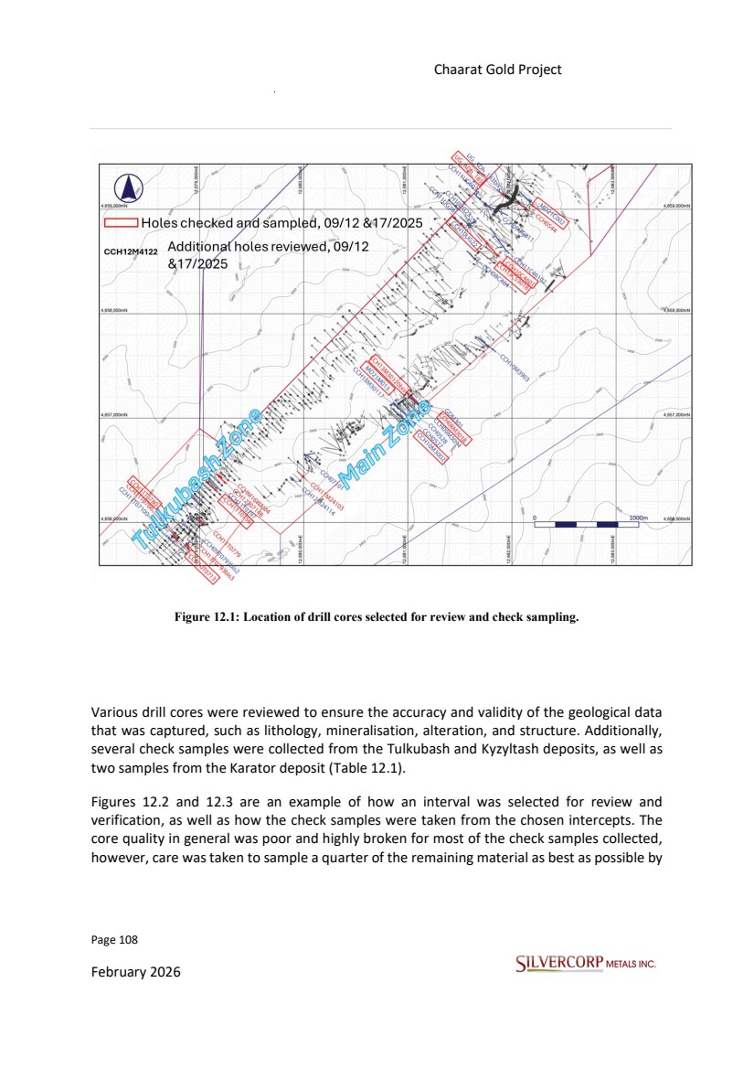
| Page 109 February 2026 Chaarat Gold Project Chatkal district, Kyrgyzstan NI 43-101 Technical Report Mineral Resource Update dividing the material with a scoop and transferring it to a plastic bag that contained a sample tag. A minimum of 1.5m and a maximum of 2m was sampled. The sample intervals were also chosen in such a manner that the check samples overlapped with previous sample intervals. The sample bags were immediately sealed and stored in a secure location, after which they were transported to the SAEL laboratory for analysis. Table 12.1: Summary of check samples taken from Tulkubash, Kyzyltash, and Karator deposits. Zone Zone BH ID Chaarat Samle ID SVM Sample ID From T o Interval Au_ppm Ag_ppm As_ppm Sb_ppm S_tot_% Au_ppm Ag_ppm As_ppm Sb_ppm S_tot_% Tulkubash 1410780026 D941351 34.50 36.00 1.50 11.30 1 1068 965 0.19 10.5 <1.0 1407 1097 0.25 Tulkubash 1410780037 D941352 49.50 51.00 1.50 4.48 1 684 537 0.07 4.94 <1.0 479 375 0.08 Tulkubash CCH10T0713 1400713033 D941353 55.50 57.00 1.50 6.34 1 144 13550 1.7 6.40 1.7 4540 3615 0.88 Tulkubash CCH10T0756 1410756048 D941354 64.50 66.00 1.50 12.78 4 2247 339 2.6 8.60 2.1 1673 291 2.23 Main Zone CCH13M30120bis 14330120055bis D941357 110.00 111.50 1.50 8.69 186 32970 7712 N A 7.43 92.6 >10000 5753 2.69 Main Zone CCH08M3018 14809733 D941358 111.00 112.50 1.50 8.17 6 >10000 5189 N A 9.23 3.5 >10000 1522 2.94 Main Zone MD21M013 10013056 D941361 84.20 86.20 2.00 10.50 12 35946 1975 2.27 8.18 12.6 >10000 3842 2.1 Main Zone 1403002146 D941364 315.00 316.50 1.50 14.91 2 19427 356 N A 13.5 2.1 >10000 492 2.75 Main Zone 1403002152 D941365 322.50 324.00 1.50 16.81 18 29769 8918 N A 10.3 10.1 >10000 2511 2.50 Contact Zone UG_Udh_185 14808381 D941359 174.00 175.50 1.50 4.44 60 >10000 205 N A 5.49 36.3 >10000 144 3.1 Contact Zone 10002167 D941362 276.00 278.00 2.00 15.70 22 29100 832 4.26 9.79 20.5 >10000 1156 4.26 Contact Zone 10002219 D941363 360.00 362.00 2.00 22.86 2 3613 14 1.76 2.14 1.5 2548 32 1.74 Contact Zone CCH13C53018 14353018137 D941366 186.00 187.50 1.50 11.10 5 9662 68 N A 4.24 2.9 5934 53 2.33 Contact Zone 150022053 D941367 70.50 72.00 1.50 4.75 17 3613 406 N A 3.83 16.9 2923 428 2.00 Contact Zone 150022063 D941368 84.00 85.50 1.50 6.15 12 16586 76 N A 5.34 4.0 >10000 51 1.53 Contact Zone 1404601097 D941369 132.50 134.00 1.50 3.10 40 10655 7506 N A 2.21 32.1 6304 3962 2.57 Contact Zone 1404601201 D941370 331.00 332.50 1.50 2.38 112 7963 1540 N A 2.37 14.1 9303 1233 3.12 Karator 4628026 D941355 30.00 31.50 1.50 4.44 1 255 44 0.03 4.88 1.1 297 87 0.23 Karator 4628092 D941356 109.50 111.00 1.50 5.02 1 998 5 0.28 5.98 <1.0 1191 14 0.28 Karator Chaarat assay values SVM check assay values Tulkubash CCH10UG022 CCH10M3002 CCH11T0780 MD21C002 CCH10C4601 DH23K628 Kyzyltash contact zone Kyzyltash main zone |
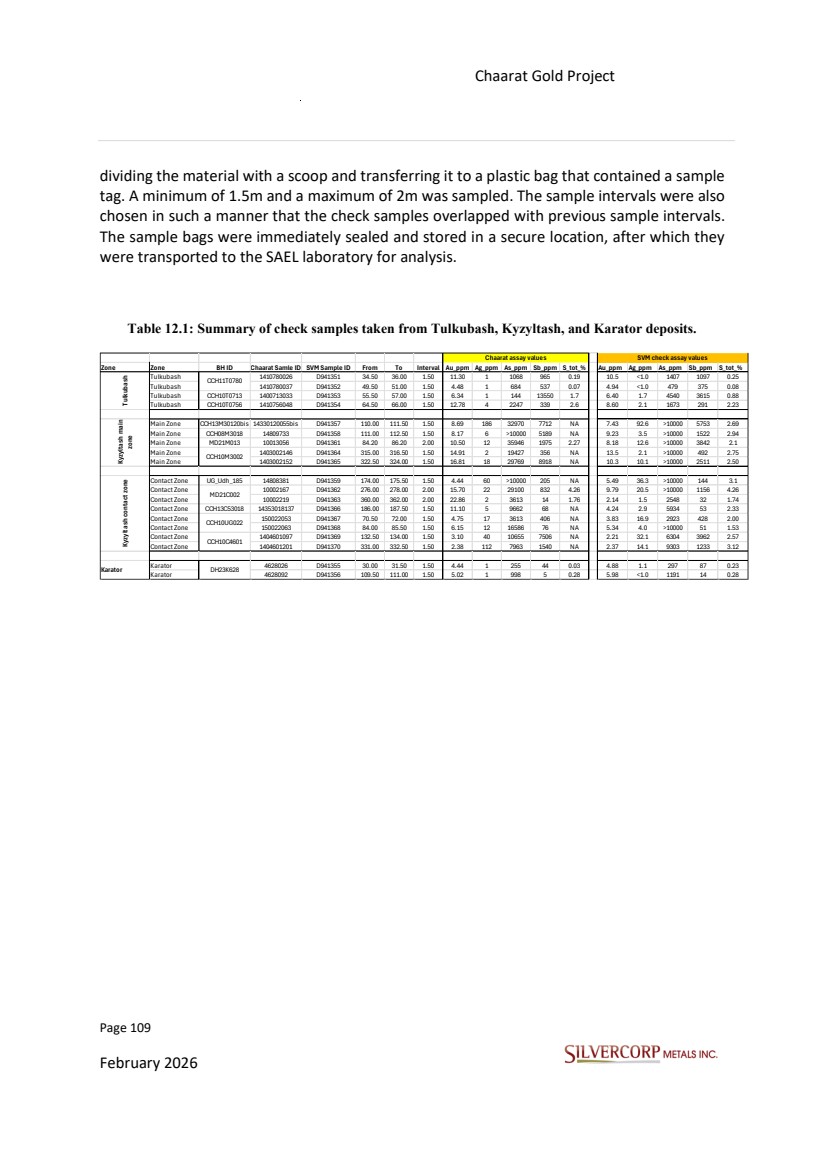
| Page 110 February 2026 Chaarat Gold Project Chatkal district, Kyrgyzstan NI 43-101 Technical Report Mineral Resource Update Figure 12.2: Representation of a mineralized interval selected for detailed review, verification, and check sampling from the Tulkubash deposit. |
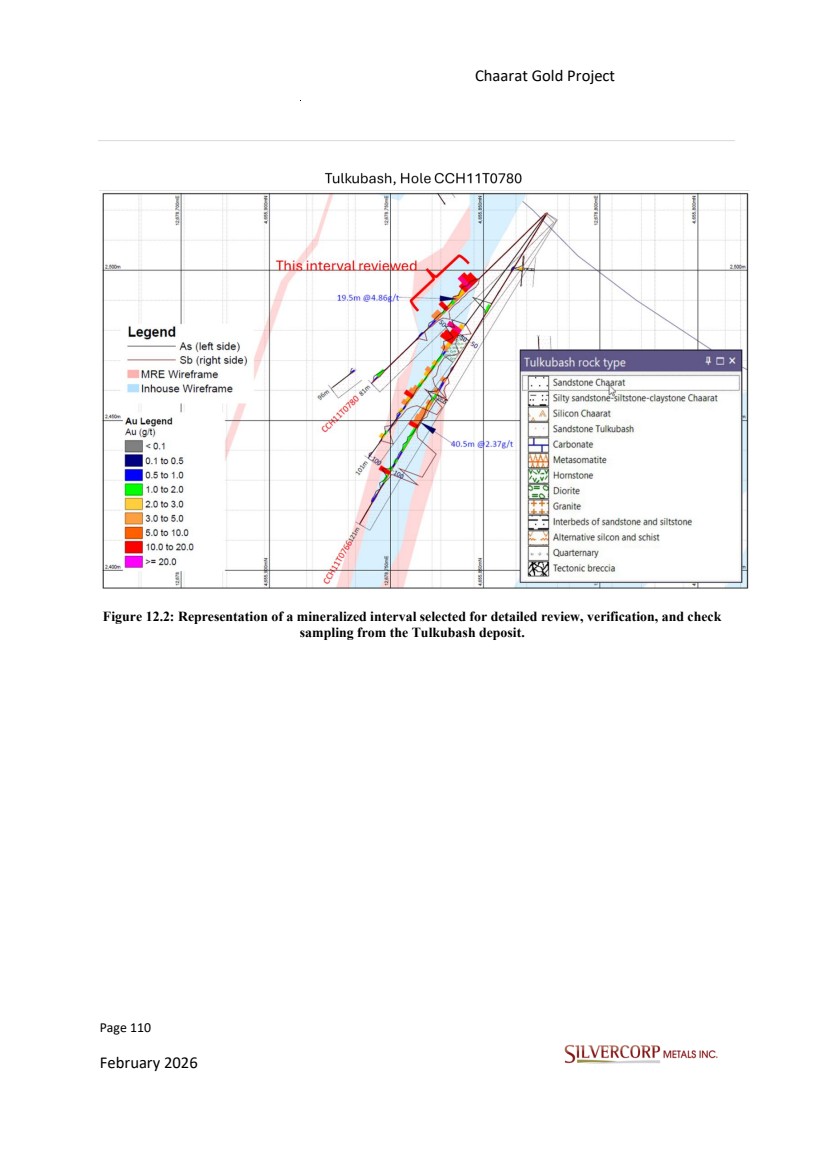
| Page 111 February 2026 Chaarat Gold Project Chatkal district, Kyrgyzstan NI 43-101 Technical Report Mineral Resource Update Figure 12.3: Close up of the interval selected for review, along with before and after images of the sample which were taken from the core boxes. Source: SVM site visit photographs, 12/09/2025. The methodology depicted in Figures 12.2 and 12.3 were replicated for each of the check samples shown in Table 12.1. 12.1.4. Drill pad review During the site visit, the drilling pads located in Tulkubash and Kyzyltash were inspected, and several drill hole collars were located (Figure 12.4). |
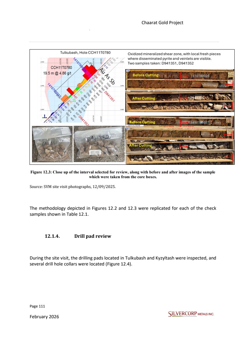
| Page 112 February 2026 Chaarat Gold Project Chatkal district, Kyrgyzstan NI 43-101 Technical Report Mineral Resource Update Figure 12.4: Photographs of drill hole collars identified and validated in the field Source: SVM site visit photographs, 14/09/2025. Two Garmin model handheld GPS units (GPDMAP 64sx and GPSmap 60CSx), each with a precision of ±5 m, were used to validate the collar locations, along with a Brunton-type compass for verification in PVC pipes at surface, where precision is lower. Drill hole identification was enabled using the PVC pipes or casings. The locations of more than twelve drill collars inspected during the site visit were compared to the original reported drill hole collar data. A summary is provided in Table 12.2 (twelve drill holes). The results show acceptable differences between the original and field verified and checked data, except for the first two holes measured, as the GPS was not adjusted to |
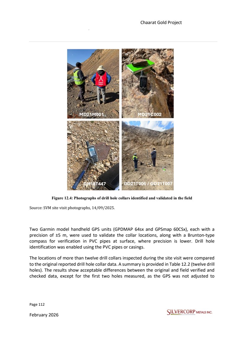
| Page 113 February 2026 Chaarat Gold Project Chatkal district, Kyrgyzstan NI 43-101 Technical Report Mineral Resource Update S42Pulkovq1(GK12zone). Overall, the agreement between the verification measurements and differential GPS data in eastings, northings and elevations is acceptable. Many drill hole locations lack PVC markers or iron pipes (casings) because of road clearing after rock falls, winter weather conditions, and the use of heavy machinery make it impossible to maintain drill hole identification in the field. Table 12.2: Summary of comparison between Chaarat (digital) and Silvercorp (field) co-ordinates for select drill holes. Hole_ID Deposit Easting (S42Pullkovq1- GK12zone) Northing (S42Pullkovq1- GK12zone) Elevation (m) Azimuth (° ) Dip (° ) Easting Northing Elevation (m) Azimuth (° ) Dip (° ) Easting Diff. (m) Northing Diff. (m) Elevation Diff. (m) Azimuth Diff. (° ) Dip Diff. (° ) MD21M001 Kyzyltash 12,682,505 4,658,351 2,256 283 -45 12,682,526 4,658,297 2,212 - - -21 54 44 - - MD21C002 Kyzyltash 12,682,173 4,659,079 2,581 310 -70 12,682,183 4,659,022 2,566 - - -10 57 15 - - DH21T593 Tulkubash 12,680,894 4,658,292 3,084 135 -60 12,680,891 4,658,299 3,084 - - 3 - 7 0 - - DH19T512 Tulkubash 12,680,962 4,658,402 3,076 135 -50 12,680,959 4,658,408 3,077 120 -60 3 - 6 - 1 15 10 DH18T447 Tulkubash 12,680,809 4,658,153 3,041 135 -75 12,680,808 4,658,158 3,044 120 -75 1 - 5 - 3 15 0 DH18T365 Tulkubash 12,680,278 4,657,849 2,914 135 -75 12,680,281 4,657,853 2,926 - - - 3 - 4 -12 - - DH21T589 Tulkubash 12,679,982 4,657,121 2,781 140 -47 12,679,978 4,657,127 2,791 - - 4 - 6 -10 - - GD21T006 Tulkubash 12,678,727 4,656,011 2,615 135 -60 12,678,728 4,656,015 2,617 130 -60 - 1 - 4 - 2 5 0 GD21T007 Tulkubash 12,678,725 4,656,012 2,615 315 -60 12,678,728 4,656,015 2,617 315 -60 - 3 - 3 - 2 0 0 RC20T001 Tulkubash 12,678,691 4,655,976 2,623 135 -73 12,678,692 4,655,977 2,624 - - - 1 - 1 - 1 - - RC20T002 Tulkubash 12,678,664 4,655,948 2,628 135 -55 12,678,663 4,655,951 2,628 120 -60 1 - 3 0 15 5 RC20T003 Tulkubash 12,678,664 4,655,949 2,628 135 -75 12,678,663 4,655,951 2,628 120 -60 1 - 2 0 15 -15 Chaarat Gold Project Silvercorp measurements Variance |
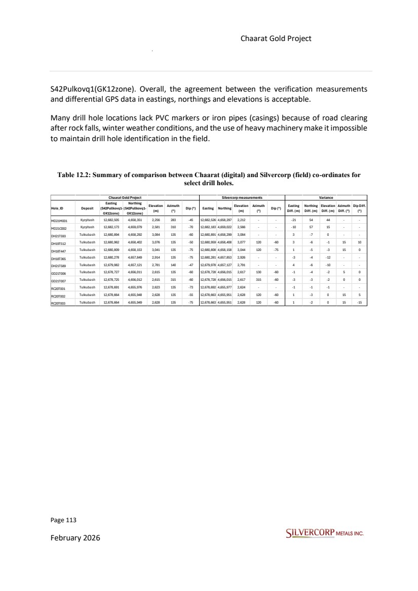
| Page 114 February 2026 Chaarat Gold Project Chatkal district, Kyrgyzstan NI 43-101 Technical Report Mineral Resource Update Table 12.3: Digital data verification, drilling campaign 2018. Collar Depth Survey Assay PDF files Average Core Recovery, % Max Core Recovery , % Min Core Recover y, % Averag e RQD Index, % Max RQD Index, % Min RQD Index, % 2018 2018 2018 2018 2018 DH18T362 & 165.3 165.3 165.3 OK There are 111 samples, and 57 samples were reviewed in 8 different sections, from which the ICP data were not found in the PDFs of samples 4362002, 4362008, and 4362084. 96 98 94 12 40 0 DH18T365 & 178.6 178.6 178.6 OK There are 119 samples, and 60 samples were reviewed in 7 different sections. Of these, the ICP data were not found in the PDFs for samples 4365116, 4365117, 4365118, and 4365119. 96 99 93 42 84 6 DH18T366 & 228.8 228.8 228.8 First 8 meters are not sampled. There are 147 samples, and 77 samples were reviewed in 9 different intervals. From these, the ICP data were not found in the PDFs for samples 4366011, 4366012, 4366013, 4366024, 4366027, 4366028, 4366034, 4366044, 4366099, and 4366104. 94 99 91 18 51 3 DH18T393 & 345 345 345 Samples with codes 4393266 and 4393267 had reassay values, but according to the client, the values from the first analysis remain Sample data for this hole were not found in the PDFs. The intervals were selected, but the review could not be performed due to the lack of information in the PDFs. 97 98 97 19 34 9 DH18T391 & 277.2 277.2 277.2 Sample with code 4391173 had a reassay value, but according to the client, the values from the first analysis remain Sample data for this well were not found in the PDFs. The intervals were selected, but the review could not be performed due to the lack of information in the PDFs. 97 99 94 30 62 8 DH18T434 & 147.5 147.5 147.5 first 18 meters are not sampled. There are 87 samples, and 50 samples were reviewed in 8 different sections, from which the FA data were not found in the PDFs for samples 4434034 and 4434036. 96 97 96 9 36 1 DH18T458 & 33 33 33 No sampling was performed for the 33m interval of this hole This hole has no sampling. 16 16 16 0 0 0 DH18T453 & 149.1 149.1 149.1 OK There are 100 samples, and 51 samples were reviewed in 9 different sections. No observations. 97 97 96 10 18 2 DH18T428bis & 300 300 300 there is no sampling from 71.5 to 78.5m There are 197 samples, and 102 were reviewed across 13 different sections, for which the ICP data were not found in the PDFs of samples 4428224, 4428226, 4428227, 4428228, 4428229, 4428231, and 4428233. 95 98 60 17 46 1 DH18T457 & 114.5 114.5 100 first 15 meters are not sampled. There are 67 samples, and 39 were reviewed in 5 different sections. No observations. 81 97 33 10 17 6 DH18T447 & 113 113 100 first 2 meters are not sampled. There are 75 samples, and 42 were reviewed across 6 different sections. From these, the ICP data from the PDFs of samples 4447029, 4447031, 4447058, 4447059, 4447061, 4447078 were not found, nor were the ICP and FA data for samples 4447084, 4447086, 4447087, 4447088, 4447089, 4447091, 4447092, and 4447093. 95 96 93 10 22 2 2018 |
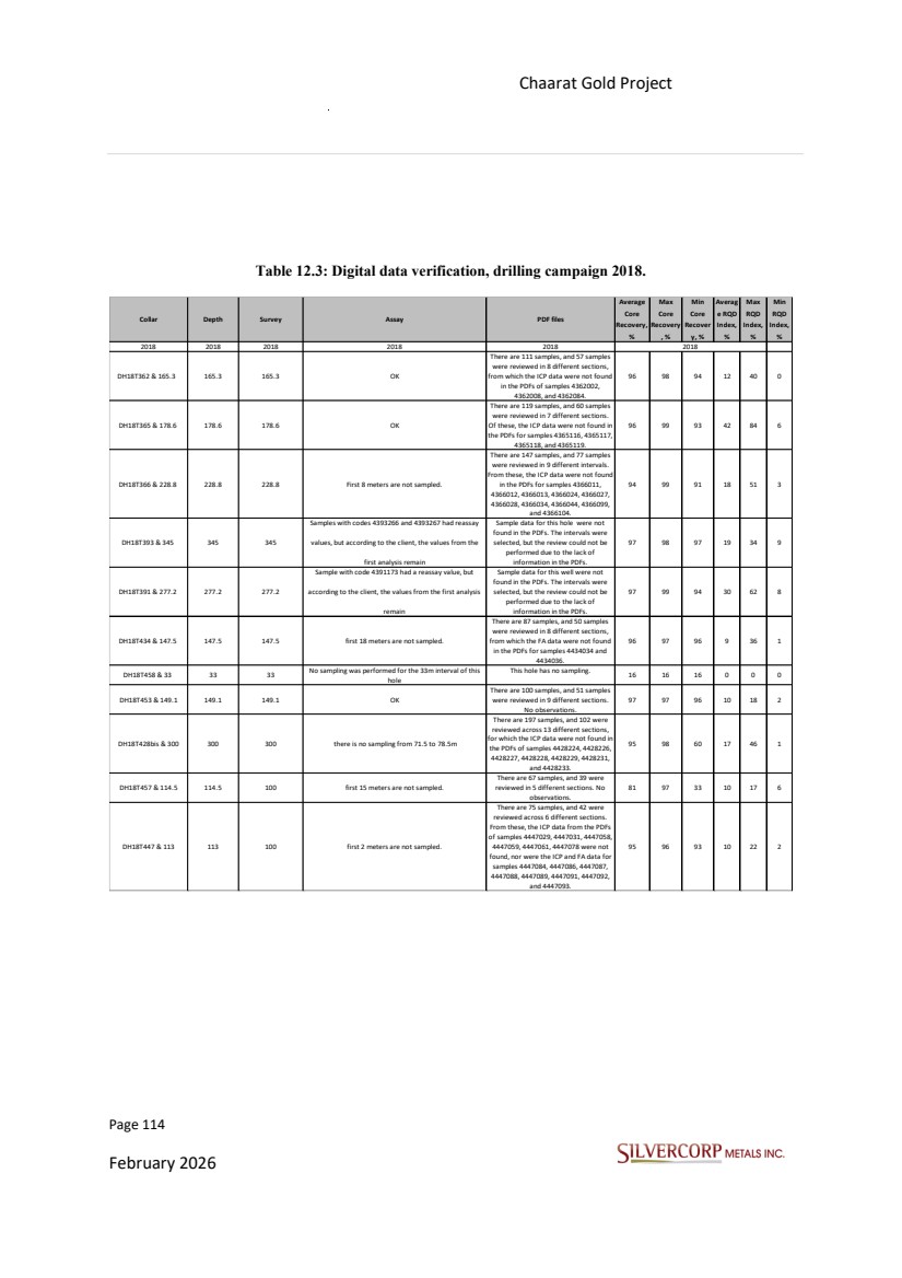
| Page 115 February 2026 Chaarat Gold Project Chatkal district, Kyrgyzstan NI 43-101 Technical Report Mineral Resource Update Table 12.4: Digital data verification, drilling campaign 2019 Table 12.5: Digital data verification, drilling campaign 2020. Collar Depth Survey Assay PDF files Average Core Recovery, % Max Core Recovery , % Min Core Recover y, % Averag e RQD Index, % Max RQD Index, % Min RQD Index, % 2019 2019 2019 2019 2019 DH19T512 & 170 170 170 first 5 meters are not sampled. There are 110 samples, and 58 were reviewed in 8 different sections. No observations. 95 96 89 24 47 14 DH19T539 & 300 300 300 OK There are 200 samples, and 102 were reviewed in 9 different sections. No observations. 96 97 95 8 26 1 DH19T554 & 317 317 317 OK There are 212 samples, and 110 were reviewed in 16 different sections. There are no observatio 96 97 95 23 41 6 DH19T476 & 177 177 177 Sample 4476058 has a silver value above the detection limit, exceeding 100 ppm. No assay was found to quantify it above this value, but a value of 200 ppm was entered in the Assay table. There are 118 samples, and 60 were reviewed in 7 different sections. No observations. 92 96 79 11 65 1 DH19T511 & 175 175 175 first 1 meter are not sampled. There are 116 samples, and 60 were reviewed in 6 different sections. No observations. 94 96 93 4 6 1 DH19T525 & 177.2 177.2 150 OK There are 121 samples, and 62 were reviewed in 7 different sections, among which the ICP data from the PDFs for sample 4325012 were not found. 97 98 94 20 30 6 DH19T583 & 177 177 177 OK There are 118 samples, and 59 were reviewed in 6 different sections. No observations. 95 96 94 8 18 0 DH19T483 & 30 30 18 OK There are 20 samples, and 11 were reviewed in 1 section. No observations. 94 94 93 0 0 0 DH19T521 & 32 32 32 OK There are 22 samples, and 12 were reviewed in one section. There are no observations. 95 96 95 2 2 2 2019 Collar Depth Survey Assay PDF files Average Core Recovery, % Max Core Recovery , % Min Core Recover y, % Averag e RQD Index, % Max RQD Index, % Min RQD Index, % 2020 2020 2020 2020 2020 RC20T001 & 125 125 123.99 Sample 8001023 in the assay table has a value of 4.130, but in the certificate it is 4.125 and in the PDF it is rounded. In this hole, sampling was performed every meter. There are 125 samples, and 65 were reviewed in 4 different sections. There are no observations. - - - - - - RC20T019 & 150.3 150.3 41.18 sampling was carried out every meter. There are 150 samples and 86 were reviewed in 6 different sections. There are no observations. - - - - - - RC20T005 & 80 80 77.59 sampling was carried out every meter. There are 80 samples, and 46 were reviewed in 3 different sections. No observations. - - - - - - 2020 |
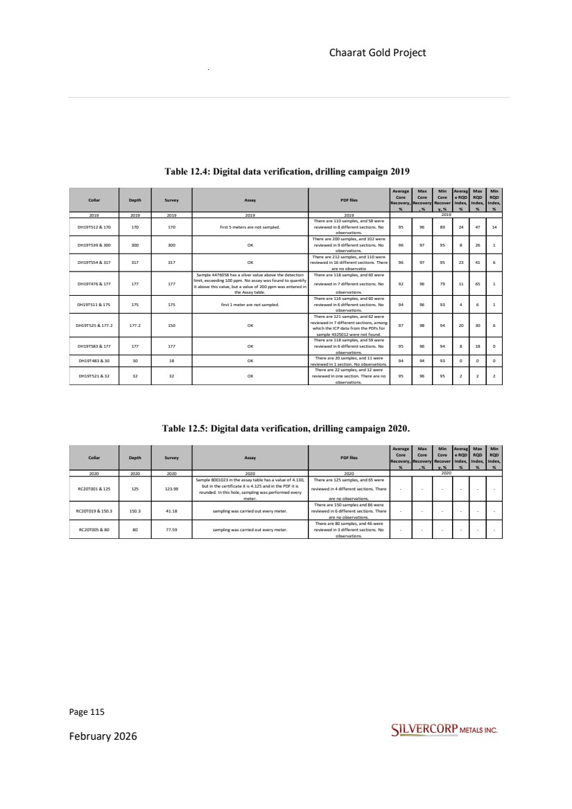
| Page 116 February 2026 Chaarat Gold Project Chatkal district, Kyrgyzstan NI 43-101 Technical Report Mineral Resource Update Table 12.6: Digital data verification, drilling campaign 2021. 12.2. QP COMMENTS Based on the data verification performed, the QP considers that the collar coordinates, downhole surveys, lithologies, mineralization and assay results comply with industry standards and are adequate for resource estimation. Collar Depth Survey Assay PDF files Average Core Recovery, % Max Core Recovery , % Min Core Recover y, % Averag e RQD Index, % Max RQD Index, % Min RQD Index, % 2021 2021 2021 2021 2021 MD21C002 & 364.6 364.6 364.6 The first 9.5 meters were not sampled, and sampling was performed every 2m. There are 178 samples, and 95 were reviewed in 11 different intervals. In this hole, in the ICP PDF, samples 10002031, 10002148, 10002168, 10002169, 10002171, 10002172, 10002173, 10002176, 10002177, 10002178, 10002179, 10002181, 10002182, 10002183, 10002184, 10002186, 10002212, 10002213, and 10002214 have arsenic values greater than 10000, but in the Excel certificate, a specific certificate was found only for arsenic values exceeding 10000 ppm, which was not found in the PDFs. 97 98 95 23 37 5 MD21M001 & 201.1 201.1 201.1The first 12 meters were not sampled, and sampling was performed every 2m. There are 99 samples and 53 were reviewed in 7 different sections. There are no observations. 97 98 97 14 37 1 DH21T593 & 175.2 175.2 125 OK There are 117 samples, and 61 were reviewed in 9 different sections. No observations. 96 97 94 6 13 1 DH21T589 & 80.1 80.1 80 OK There are 54 samples, and 30 were reviewed in 3 different sections. No observations. 97 98 94 10 24 1 GD21T006 & 200 200 200 sample codes are present as if sampling had been performed, but no geochemical data exist in the Assay table nor in the certificates. It is a geotechnical hole. No sampling 92 95 85 15 24 9 DH21I596 & 285 285 285 OK There are 193 samples, and 99 were reviewed in 15 different sections. There are no observations. 94 98 88 16 41 1 2021 |
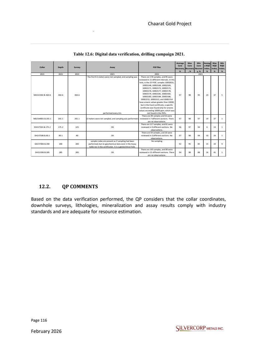
| Page 117 February 2026 Chaarat Gold Project Chatkal district, Kyrgyzstan NI 43-101 Technical Report Mineral Resource Update 13. MINERAL PROCESSING AND METALLURGICAL TESTING 13.1. INTRODUCTION More than seven organizations worked on metallurgical test work and historical research between 2005 and 2021, including internal study-reports by the Chaarat Gold Project technical team. The reports by Mr. Dimitar Lazarov Dimitrov MAIG, Mineral Resource update, Tulkubash zone, Republic of Kyrgyzstan, Effective Date of Report: 5 February 2017 and “Kyzyltash Gold Project Mineral Resource Update, CHAARAT ZAAV CJSC, Date: October 15th, 2024” deliver the final summary of metallurgical studies. 13.2. Tulkubash A more efficient method for predicting gold recovery has been developed for the Tulkubash deposit, focusing on the oxidation state of the rock rather than its total sulphur content. The Tulkubash resource is an oxidized gold deposit that will be mined via open pit methods with heap leaching to be selected as the processing and recovery method. Historical Test work source: Tetra Tech report Tetra Tech (Competent Person Report for Chaarat Gold Project, Kyzrgyz Republic, Dec.2018); As part of the Feasibility Study, two commercial laboratories completed additional metallurgical test work: WAI (2017), UK and MCL (2018), Reno, Nevada, USA. WAI tested 23 variability composite samples collected from dedicated metallurgical drillholes within the Tulkubash zone of mineralization, but these were not restricted to the proposed Feasibility Study pit. WAI also tested two master composites; the first master composite consisted of sub-samples from all variability samples and the second master composite |
| Page 118 February 2026 Chaarat Gold Project Chatkal district, Kyrgyzstan NI 43-101 Technical Report Mineral Resource Update consisted of selected variability samples representing the heap leach ore within the Feasibility Study pit. WAI completed the test work between October 2016 and March 2017. MCL completed a separate test work program in 2018, which included a variability test program consisting of 48 coarse ore bottle roll tests, followed by 8 column leach tests simulating heap leach conditions. MCL began the test work in December 2017 with the results available as of 26th March 2018, which are included in this report. Tetra Tech analyzed all the metallurgical test work results with the objective of identifying optimal heap leach conditions. The WAI and MCL metallurgical studies indicate that the oxide ore is amenable to cyanide heap leaching and can be efficiently processed using a heap-leach based flowsheet. Based on the metallurgical test work results, the LOM recovery for gold and silver is estimated to be 76.5% and 61.8%, respectively. 13.3. Kyzyltash A comprehensive metallurgical study was conducted by SGS in 2021-2022 to determine the optimal processing flowsheet for the Kyzyltash deposit. The study utilized material from a dedicated 3,500-meter representative drilling program to collect approximately 395 meters of mineralized core, which consisted of 16 PQ-diameter holes drilled as twins to historical holes to ensure accurate intersection of the ore zones. The Kyzyltash deposit, comprising the Contact and Main Zones, is planned for an underground-only extraction of the Contact Zone based on the RPEE analysis, while a hybrid open pit and underground mining approach for the other zones remains a possibility for future evaluation. Samples from the Main Zone (grading 2.5 g/t Au) and the Contact Zone (grading 3.57 g/t Au) were sent to SGS Canada's mineralogy facility and were confirmed to be highly representative of the deposit. SGS then evaluated several processing flowsheets, including flotation |
| Page 119 February 2026 Chaarat Gold Project Chatkal district, Kyrgyzstan NI 43-101 Technical Report Mineral Resource Update combined with cyanidation, pressure oxidation (POX), the Albion™ process, or the BIOX® process. The results demonstrated that the Flotation + BIOX® + Carbon-in-Leach (CIL) flowsheet achieved the highest overall gold recoveries. The superior performance of BIOX® was attributed to its high sulphide oxidation efficiency and its immunity to the "preg-robbing" issues that likely hindered the pressure oxidation tests. Based on these findings, the selected processing flowsheet for the refractory Kyzyltash material is Flotation -> BIOX® on Flotation Concentrate -> CIL. This is projected to yield overall gold recoveries of 88.2% for the Contact Zone and 82.2% for the Main Zone. Table 13.1: Gold recovery following various recovery methods of test samples from Kyzyltash main and contact zones (SGS, 2022). |
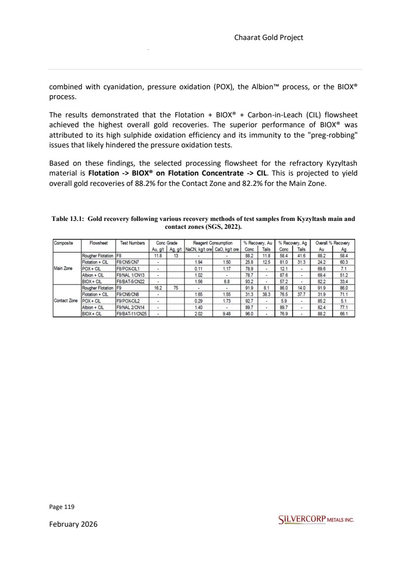
| Page 120 February 2026 Chaarat Gold Project Chatkal district, Kyrgyzstan NI 43-101 Technical Report Mineral Resource Update 14. MINERAL RESOURCE ESTIMATES 14.1. INTRODUCTION This section describes the Mineral Resource Estimate for the ore bodies of Tulkubash and Kyzyltash identified within the Chaarat Gold Project. 14.2. KEY ASSUMPTIONS AND BASIS OF ESTIMATE Alex Zhang (QP) conducted on-site data verification, the details of which are presented in Section 12. It was concluded that the collar coordinates, downhole surveys, lithological logging, mineralization intervals, and assay results conform to current industry standards and are suitable to support mineral resource estimation. For the current resource update, the Tulkubash deposit estimate is supported by 711 drillholes totalling 100,791 meters, while the Kyzyltash deposit estimate is based on 384 drillholes totalling 78,735 meters (Table 14.1). Not all historical and new holes were used in the update of the new Mineral Resource Estimate since the historical database -and the one to date- includes holes outside of the current geological models delivered by the geology team, which are the basis of this Mineral Resource Estimate. Only validated drillholes intersecting or relevant to these models were selected and carried forward into the grade interpolation process. The wireframing and grade interpolation processes were completed via Micromine software platform. Table 14.1: Summary of drilling used in the current resource estimate by year Figures 14.1 shows a map without restriction in a plan view where the distribution of drill holes is displayed for each zone and the 3D model. The location, azimuth, and dip of Chaarat Gold Project drill holes from 2000 to 2021 are listed in Appendix 4. Deposit Year 2000 2004 2005 2006 2007 2008 2009 2010 2011 2012 2013 2014 2017 2018 2019 2020 2021 Total # of Holes 1 5 12 5 37 128 39 14 47 132 122 124 21 24 711 Total Meter 151 1,130 2,375 803 4,272 15,984 6,842 1,781 5,760 17,307 19,935 19,257 2,434 2,760 100,791 # of Holes 7 5 33 22 40 69 21 28 44 25 74 16 384 Total Meter 1,803 857 6,677 4,577 8,018 15,745 4,804 5,597 13,344 2,745 11,060 3,508 78,735 Tulkubash Kyzyltash |
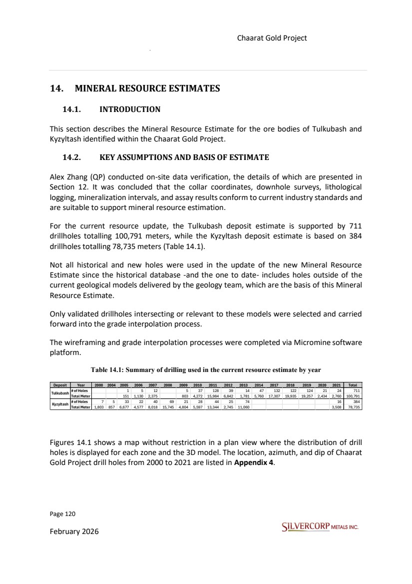
| Page 121 February 2026 Chaarat Gold Project Chatkal district, Kyrgyzstan NI 43-101 Technical Report Mineral Resource Update Figure 14.1: Planview of ore model 3D, and drill holes used in the current resource estimation. 14.3. WIREFRAME MODEL The mineralization interpretation was done without reference to any historical models. All mineralized wireframes were constructed by integrating all available geological data, |
| Page 122 February 2026 Chaarat Gold Project Chatkal district, Kyrgyzstan NI 43-101 Technical Report Mineral Resource Update including drilling, surface mapping, and underground workings. It should be noted, however, that only validated drillhole data were utilized during subsequent resource estimation. The interpretation prioritized the continuity of mineralization trends and structural alignment, emphasizing zones of consistent grade rather than isolated high-grade intercepts. Each mineralization wireframe was constructed based on at least two independent data points, such as drillhole intersections or trench samples, to ensure geological reliability. Where justified by geological continuity, wireframes were extended along the interpreted mineralization trend down dip and along strike for a distance of 25 to 50 meters or up to half the distance to the nearest barren drillhole. All wireframes and their basic statistics are listed in Table 14.2 and Table 14.3. It is important to note that not all mineralized drillhole intercepts were necessarily incorporated into the final wireframes. Only those contributing to a continuous, geologically reasonable trend were incorporated. Intercepts that were isolated or inconsistent with the defined trends were excluded from the modelled domains. Consequently, these excluded intercepts represent potential resource upside, as they may be connected or better understood with further drilling, potentially leading to an expansion of the mineralized wireframes and the overall resource estimate. Beyond the primary division into the Tulkubash and Kyzyltash deposits, the Kyzyltash area was further subdivided into sub-domains, specifically the Main Zone (MZ) and the Contact Zone (CZ). This zoning/naming convention originated from historical exploration practices and largely used within the historical database and hence was applied in this report as well. |
| Page 123 February 2026 Chaarat Gold Project Chatkal district, Kyrgyzstan NI 43-101 Technical Report Mineral Resource Update Table 14.2: List of all ore wireframes in Tulkubash Wireframes Deposit Triangles Points Surface Area (m2) Volume (m3) Validated Tul_01 Tulkubash 756 380 189053.3 1127857 Closed, valid Tul_02 Tulkubash 108 56 16054.71 44206.25 Closed, valid Tul_03 Tulkubash 222 113 58261 136848.1 Closed, valid Tul_04 Tulkubash 68 36 17084.04 14866.18 Closed, valid Tul_05 Tulkubash 30 17 5182.351 7322.504 Closed, valid Tul_06 Tulkubash 1080 542 450880.3 1735433 Closed, valid Tul_07 Tulkubash 160 82 72266.87 210895.1 Closed, valid Tul_08 Tulkubash 42 23 17540.11 52270.58 Closed, valid Tul_09 Tulkubash 496 248 229508.6 683609.8 Closed, valid Tul_10 Tulkubash 122 63 58818.78 512785.5 Closed, valid Tul_11 Tulkubash 64 34 25128.63 109216.4 Closed, valid Tul_12 Tulkubash 148 76 34296.73 99807.64 Closed, valid Tul_13 Tulkubash 90 47 36303.17 110871.5 Closed, valid Tul_14 Tulkubash 66 35 20974.23 33337.8 Closed, valid Tul_15 Tulkubash 72 38 67499.21 343846.9 Closed, valid Tul_16 Tulkubash 42 23 29576.98 63976.69 Closed, valid Tul_17 Tulkubash 174 89 20682.52 76634.67 Closed, valid Tul_18 Tulkubash 212 108 74906.95 433739.6 Closed, valid Tul_19 Tulkubash 66 35 3878.497 14648.71 Closed, valid Tul_20 Tulkubash 40 22 8120.164 6074.527 Closed, valid Tul_21 Tulkubash 194 99 48776.84 193685 Closed, valid Tul_22 Tulkubash 114 59 71687.49 326295.4 Closed, valid Tul_23 Tulkubash 176 90 35285.37 126015.3 Closed, valid Tul_24 Tulkubash 170 87 197090.1 906293.7 Closed, valid Tul_25 Tulkubash 134 69 116248.1 1619591 Closed, valid Tul_26 Tulkubash 408 206 151686.4 374640 Closed, valid Tul_27 Tulkubash 90 47 31054.37 53591.82 Closed, valid Tul_28 Tulkubash 142 73 44306.3 235941.4 Closed, valid Tul_29 Tulkubash 116 60 69868.76 283596.3 Closed, valid |
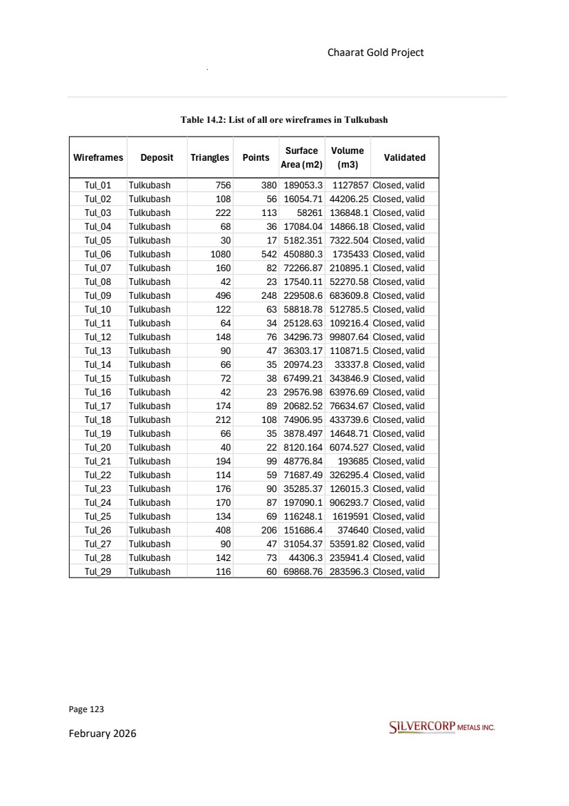
| Page 124 February 2026 Chaarat Gold Project Chatkal district, Kyrgyzstan NI 43-101 Technical Report Mineral Resource Update Table 14.3: List of all ore wireframes in Kyzyltash As illustrated in the figures below, Figure 14.2 presents all veins in plan view, offering a comprehensive overview of their spatial distribution. Figure 14.3 to Figure 14.5 further detail the vein geometries by displaying slices at various locations, providing insight into their orientation. Wireframes Deposit Triangles Points Surface Area (m2) Volume (m3) Validated Kyz_01 Kyzyltash 176 90 61986.85 195364.4 Closed, valid Kyz_02 Kyzyltash 138 71 173173.8 815603.8 Closed, valid Kyz_03 Kyzyltash 74 39 63696.06 129152.8 Closed, valid Kyz_04 Kyzyltash 56 30 34313.06 129320.8 Closed, valid Kyz_05 Kyzyltash 150 79 49354.71 165844.9 Closed, valid Kyz_06 Kyzyltash 46 25 32590.59 112578.9 Closed, valid Kyz_07 Kyzyltash 1052 527 832743.2 5990510 Closed, valid Kyz_11 Kyzyltash 84 44 57659.03 190700.5 Closed, valid Kyz_12 Kyzyltash 126 65 155981.3 478980.8 Closed, valid Kyz_13 Kyzyltash 502 253 218007.5 1104176 Closed, valid Kyz_14 Kyzyltash 360 182 129911.2 803534.4 Closed, valid Kyz_15 Kyzyltash 1116 560 1649356 15964420 Closed, valid Kyz_16 Kyzyltash 196 99 74943.75 297084.2 Closed, valid Kyz_17 Kyzyltash 114 59 99831.47 314844.6 Closed, valid Kyz_18 Kyzyltash 60 32 16038.06 110225.3 Closed, valid Kyz_20 Kyzyltash 200 102 334857.6 972880.1 Closed, valid Kyz_21 Kyzyltash 134 69 41952.78 75009.38 Closed, valid Kyz_22 Kyzyltash 174 89 43921.62 127575.3 Closed, valid Kyz_23 Kyzyltash 396 200 337664.2 6039314 Closed, valid Kyz_27 Kyzyltash 774 389 436568.1 1430913 Closed, valid Kyz_28 Kyzyltash 138 71 103105.2 416492 Closed, valid Kyz_29 Kyzyltash 144 74 410885 1646950 Closed, valid Kyz_30 Kyzyltash 86 45 29254.57 60900.66 Closed, valid Kyz_31 Kyzyltash 142 73 41233.47 110038 Closed, valid |
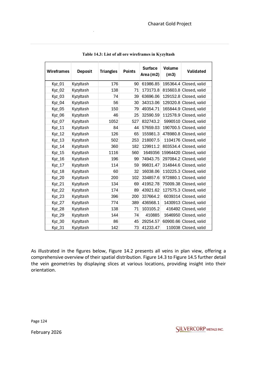
| Page 125 February 2026 Chaarat Gold Project Chatkal district, Kyrgyzstan NI 43-101 Technical Report Mineral Resource Update Figure 14.2: Spatial distribution of mineralized wireframes for Tulkubash and Kyzyltash deposits. |
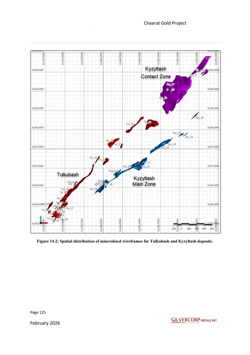
| Page 126 February 2026 Chaarat Gold Project Chatkal district, Kyrgyzstan NI 43-101 Technical Report Mineral Resource Update Figure 14.3: Planview of Tulkubash, drill holes used in the current resource estimation, pit silhouette, and ore model sliced at 2500ml. |
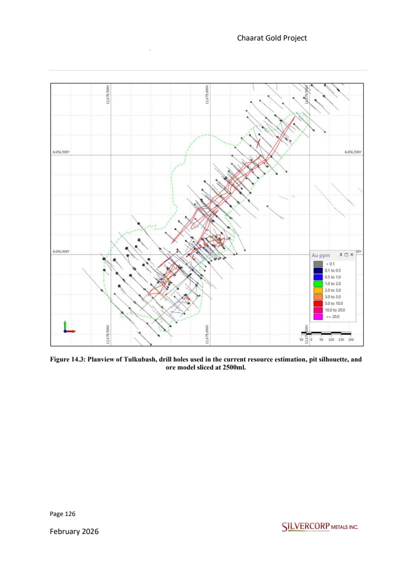
| Page 127 February 2026 Chaarat Gold Project Chatkal district, Kyrgyzstan NI 43-101 Technical Report Mineral Resource Update Figure 14.4: Planview of Kyzyltash Main Zone, drill holes used in the current resource estimation, ore sliced at 2350ml with +/-100m clipping window. |
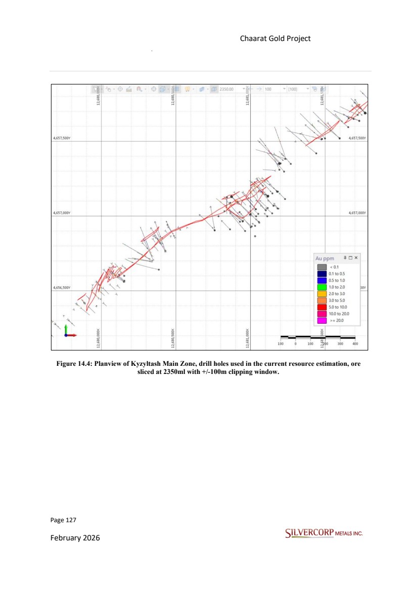
| Page 128 February 2026 Chaarat Gold Project Chatkal district, Kyrgyzstan NI 43-101 Technical Report Mineral Resource Update Figure 14.5: Kyzyltash Contact Zone, drill holes used in the current resource estimation, looking down dip through Kyz_15. |
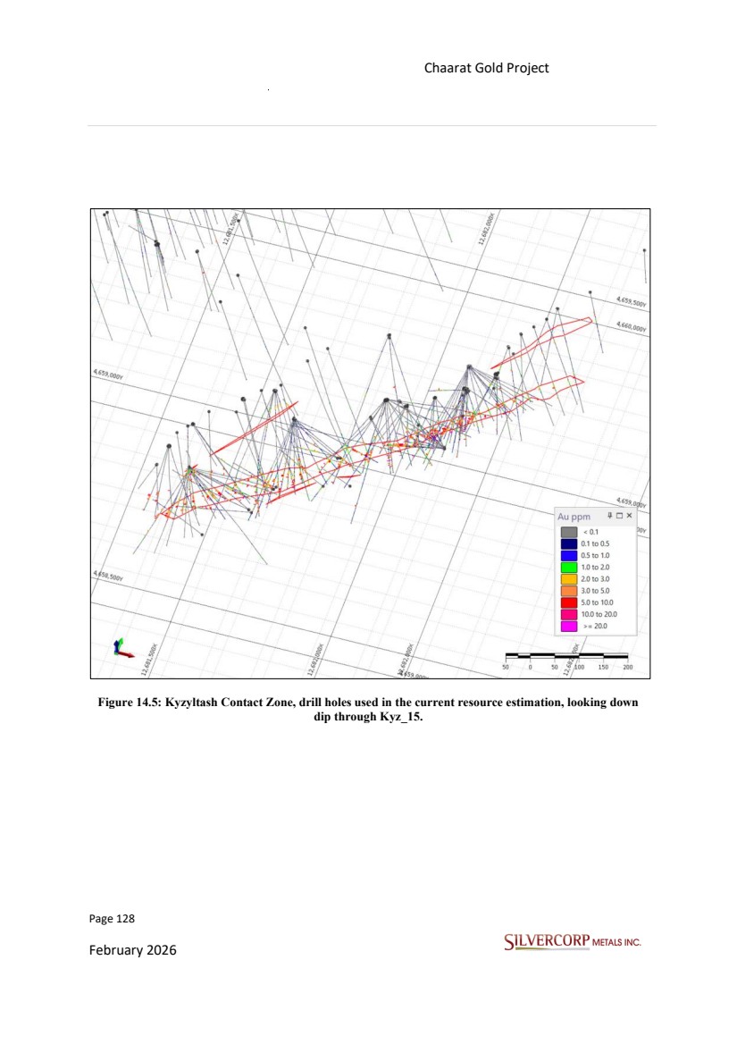
| Page 129 February 2026 Chaarat Gold Project Chatkal district, Kyrgyzstan NI 43-101 Technical Report Mineral Resource Update 14.4. TOPOGRAPHIC DATA The Chaarat Property is characterized by varied topographic relief, situated within a landscape of significant elevation changes. The property encompasses the Sandalash Valley, which lies at an altitude of approximately 2,100 m above sea level. This valley, ranging from 100 to 300 m in width, is flanked by steep slopes that rise sharply to surrounding ridges with peaks reaching up to 3,600 m. The topographic surface applied in the current resource update remains unchanged from the previous estimates. It was provided by Chaarat ZAAV team membersin DXF format and serves as the consistent topographical reference for modeling. 14.5. UNDERGROUND WORKINGS The so-called Adit 4 was developed in the Contact Zone ore body aiming to provide representable technical data and further to be used as access for wider mining activities. The total length of Adit 4 is about 2.1 km, and the sampling channel length is about 1.6 km. |
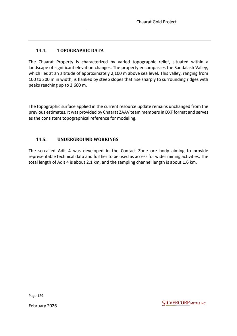
| Page 130 February 2026 Chaarat Gold Project Chatkal district, Kyrgyzstan NI 43-101 Technical Report Mineral Resource Update Figure 14.6: Contact Zone adit 4, total length of approximately 2.1 km 14.6. BULK DENSITY DATA Instead of assigning global average densities, IDW2 was used to estimate density for the Tulkubash and Kyzyltash wireframes, based on the estimation parameters detailed below. For any blocks that did not receive a density estimate through this process, average values were assigned. These values were 2.68 t/m³ for Tulkubash and 2.76t/m³ for Kyzyltash. The QP has reviewed different files for bulk density measurements from 2008 to 2019, the analysis details can be seen in Section 11.3. |
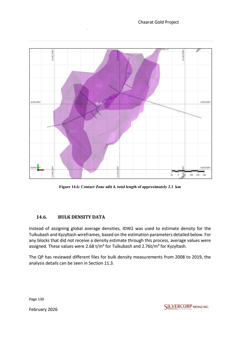
| Page 131 February 2026 Chaarat Gold Project Chatkal district, Kyrgyzstan NI 43-101 Technical Report Mineral Resource Update Table 14.3 summarizes basic statistics for bulk density determinations for Tulkubash and Kyzyltash. Table 14.4: Summary bulk density statistics. Number of Samples Mean Median Standard Deviation (SD) Variance Tulkubash 324 2.68 2.68 0.146 0.021 Kyzyltash 436 2.76 2.77 0.158 0.025 The density estimate follows the same method as grade interpolation. The blocks not reached by the estimation were assigned the arithmetic mean values, according to Table 14.3. Table 14.5: Density estimation parameters. 14.7. EXPLORATORY DATA ANALYSIS (EDA) 14.7.1. Introduction Exploratory data analysis (EDA) consisted of a basic statistical evaluation of the assays and composites for different elements and sample length. The review was conducted to identify geological variables controlling grade distribution within the deposits, and to establish a methodology for treating anomalous values within each estimation unit. Domain EST. Pass Method Min Sample count Min Hole Max per Quadrant Major Distance Minor Distance Vert. Axes All Wireframes 1 IDW2 3 2 3 50 15 37.5 All Wireframes 2 IDW2 2 1 3 80 24 60 All Wireframes 3 IDW2 1 1 3 200 60 150 |
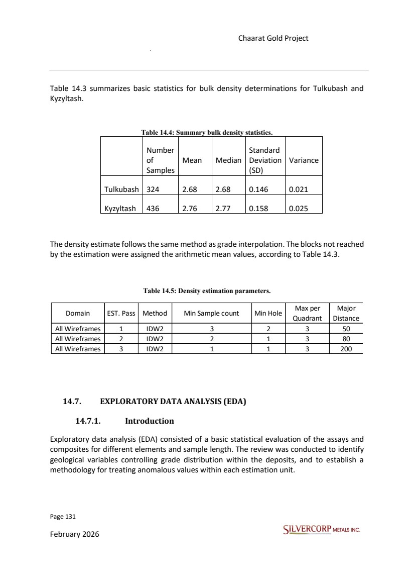
| Page 132 February 2026 Chaarat Gold Project Chatkal district, Kyrgyzstan NI 43-101 Technical Report Mineral Resource Update 14.7.2. Grade histograms, Frequency Plots Exploratory data analysis incorporated additional statistics and plots, including box plots, histograms, and probability and quantile-quantile plots for distributional comparisons. Histograms and probability plots were the primary tools used to understand grade distributions within the wireframes. The following figures display the histogram and fundamental statistics for the drill hole data within the mineralized wireframe. Gold Beyond histograms, probability plots serve as a key statistical tool. It is common practice to use these plots for the visual assessment of whether grade capping is necessary and for the selection of the corresponding threshold. Figure 14.7: Histogram and frequency plot basic statistics (Au ppm). Silver For silver (Ag), an identical basic statistical analysis was conducted. Figure 14.8 displays a plot which illustrates the summary statistics. Note that the overall silver grades within this zone are relatively low and not statistically significant. |
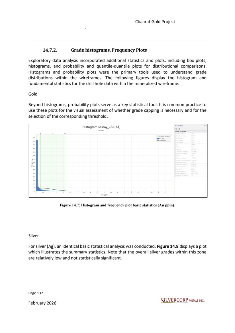
| Page 133 February 2026 Chaarat Gold Project Chatkal district, Kyrgyzstan NI 43-101 Technical Report Mineral Resource Update Figure 14.8: Histogram and frequency plot basic statistics (Ag ppm). Arsenic The Chaarat project mineralized zones are characterized by generally high arsenic (As) contents. Figure 14.9 displays a plot which illustrates the summary statistics. Figure 14.9: Histogram and frequency plot basic statistics (As ppm). |
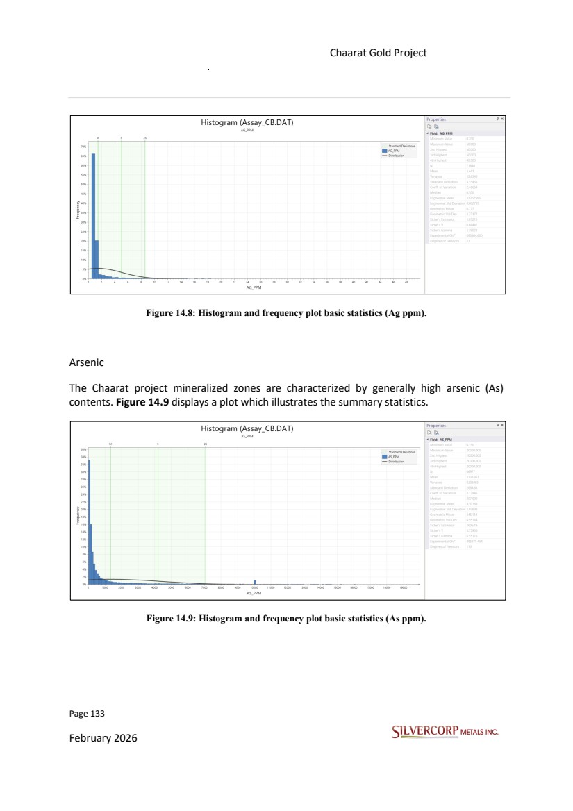
| Page 134 February 2026 Chaarat Gold Project Chatkal district, Kyrgyzstan NI 43-101 Technical Report Mineral Resource Update Antimony The analysis also included antimony (Sb), for which basic statistics were examined. However, antimony values are generally insignificant throughout the deposit. Figure 14.10: Histogram and frequency plot basic statistics (Sb ppm). 14.7.3. Assay Compositing The assay database was prepared in Micromine software. First, each drill hole interval with Au grades was assigned an X/Y/Z coordinate for the mid-point using the 3D Coordinates process. The assay data was assigned with the ore wireframe names. Finally, these coded intervals were composited to 1.5m, which is the nominal sample length. Sampling procedures at Tulkubash and Kyzyltash generally produce samples of 1.5 m in length, with the present case being an exception. The objective of sample compositing for statistical analysis and grade estimation is to reduce the variability of gold grades and to maintain, or achieve, uniform support. The use of 1.5 m composites allows for the capture of the greatest grade variability while ensuring an adequate number of samples for estimation, particularly in areas where sample density is limited. |
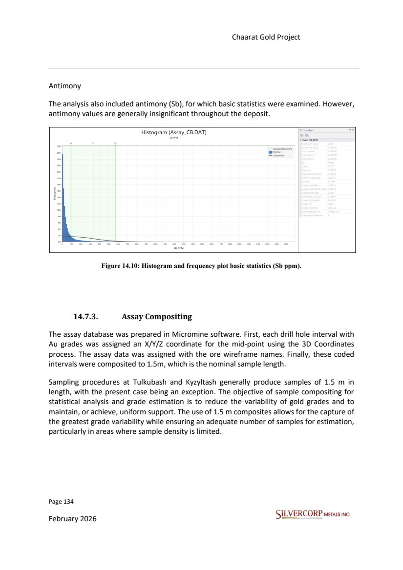
| Page 135 February 2026 Chaarat Gold Project Chatkal district, Kyrgyzstan NI 43-101 Technical Report Mineral Resource Update Figure 14.11: Histogram showing majority of samples of 1.5 m length. All the above confirms that, in this Mineral Resources update, strict control must be maintained over the estimation parameters. These include the minimum and maximum number of composites, the use of different search ranges across estimation passes, and the spatial restriction of high-grade outlier values, while also respecting the anisotropy of the various ore body domains. Such controls ensure that the estimated global mean grade remains close to the global mean of the composites for each domain, thereby minimizing the risk of global bias. 14.7.4. High-Grade Outliers The QP evaluated the Decile plots for the assay data to identify grade outliers. This work builds on the previous assessment completed by GeoSystems International Inc., which was also reviewed as part of this analysis. The QP confirmed that the methodology used to define a 3D spatial restriction for high-grade outlier values is appropriate and will be applied in this Mineral Resource estimate for gold, silver, arsenic, and antimony. Grade capping was applied after assay compositing. Gold was capped at 40 ppm and silver at 200 ppm. This approach ensures that the influence of isolated high-grade samples is appropriately limited without unduly smoothing the local grade distribution. |
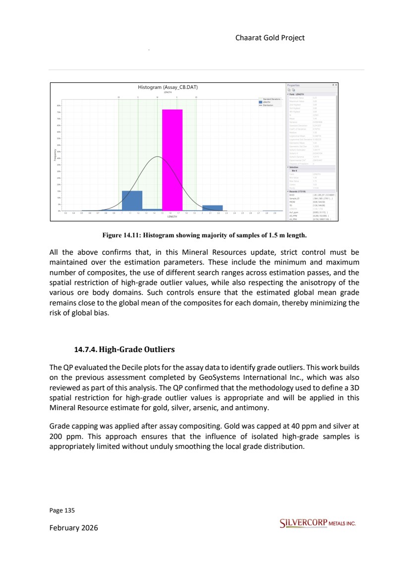
| Page 136 February 2026 Chaarat Gold Project Chatkal district, Kyrgyzstan NI 43-101 Technical Report Mineral Resource Update Figure 14.12: Decile analysis showing the top cut statistics for Au. Figure 14.13: Decile analysis showing the top cut statistics for Ag. |
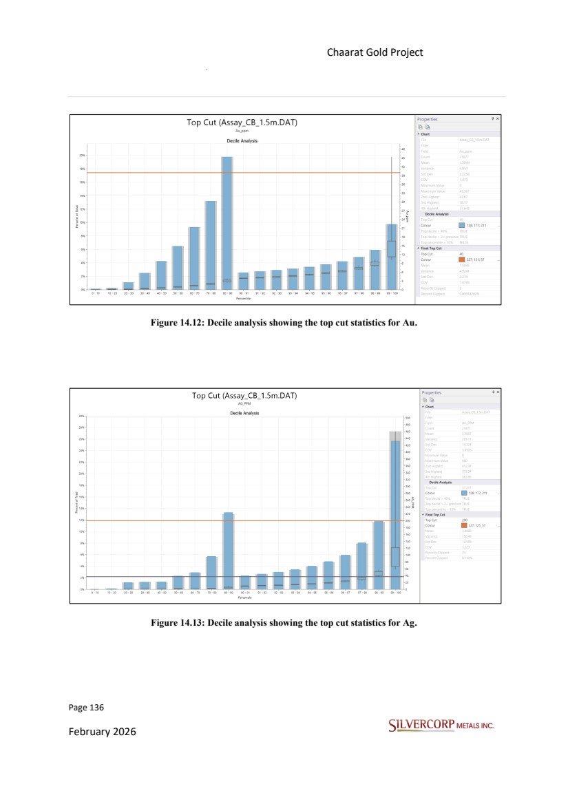
| Page 137 February 2026 Chaarat Gold Project Chatkal district, Kyrgyzstan NI 43-101 Technical Report Mineral Resource Update 14.8. BLOCK MODEL DEFINITION The Chaarat Gold Project Mineral Resource model update was arranged into one block model where all mineralized vein systems are located within the Micromine® software. Table 14.6: Chaarat block model definition. Keys defined within this Resource block model: 1. Non-Rotated Block Model: rotation will not be necessary due to the inclusion of 1.0m subcells for each of the x, y, and z axes in a uniform block size of 10m x 10 m x 10 m with subcell 1 m. 2. Elevation: is the crest elevation of the top bench in the model. 3. Envelope (wireframe): The objective of this process is to generate a consolidated block model that incorporates all mineralized vein systems within a single file. By utilizing subcells, this approach eliminates the need for model rotation and ensures that the block model remains manageable and suitable for analysis. 4. Grade and density: the estimate was made in blocks of subcells between 10.00 m and 1.00 m on the x, y, and z axes. 5. Open Pit model Tulkubash: the official Resource Model has a parent block of 10 m x 10 m x 10 m. NI 43-101 defines a mineral resource as that portion of the mineral inventory that has reasonable prospects for economic extraction. 14.9. GRADE ESTIMATION To address the gradual changes in mineralization across the deposits, a combined approach was adopted. Rather than defining static search ellipsoids for each set of veins with similar strike and dips, generalized trend files were generated to systematically capture these changes. These trend files essentially represent a dynamic anisotropy model composed of ellipsoids and were incorporated into the estimation process. Min Center Block Size (m) Max Center Blocks Min Size (m) East 12678535.5 10 12683033.5 452 1 North 4655552.5 10 4661384.5 585 1 Elevation 1753.5 10 3040.5 131 1 |
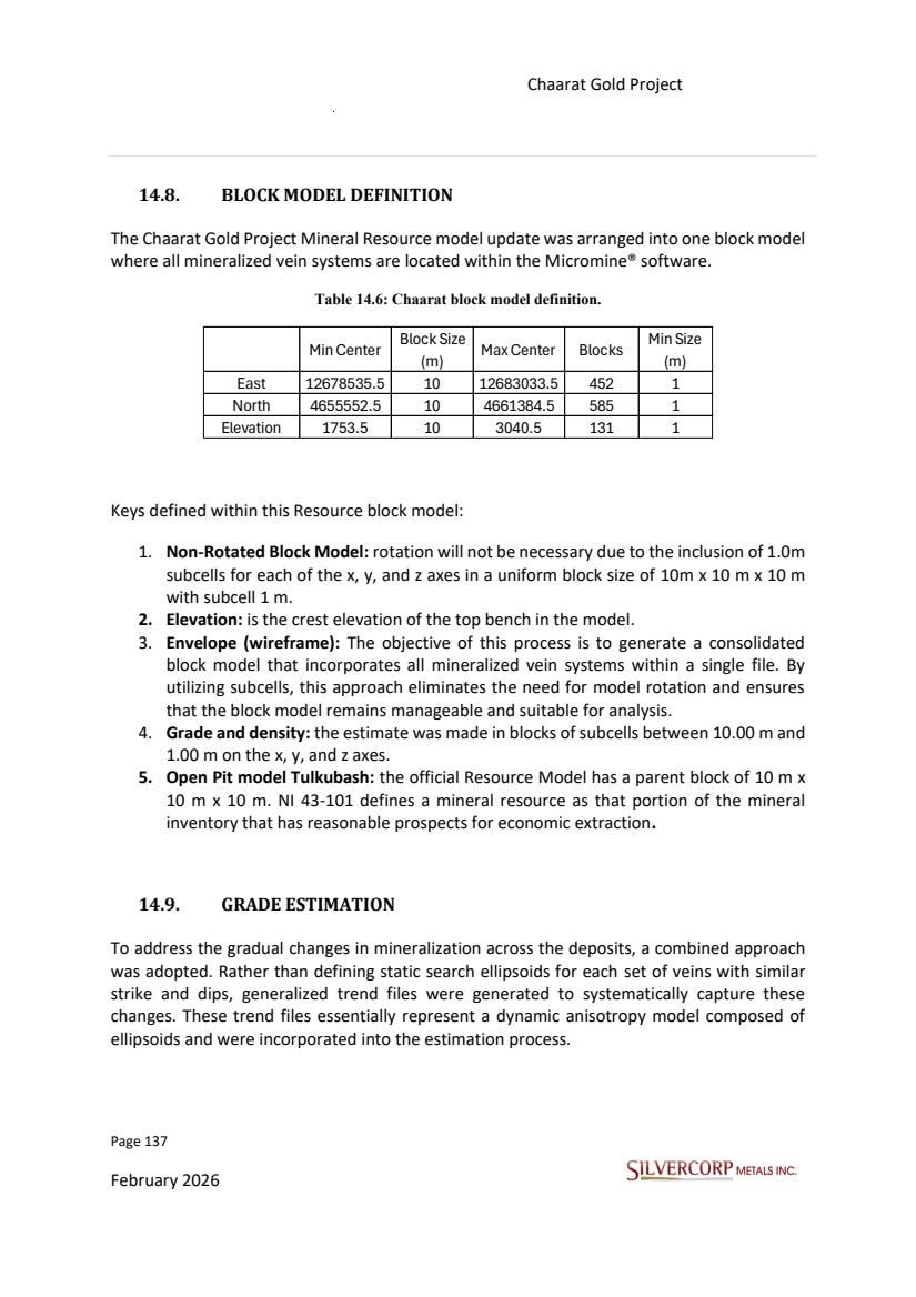
| Page 138 February 2026 Chaarat Gold Project Chatkal district, Kyrgyzstan NI 43-101 Technical Report Mineral Resource Update Where the general trends did not adequately represent local conditions, supplementary search ellipsoids were also created and applied. This dual approach ensures that both the gradual regional variations and specific local anomalies are accurately accounted for in the resource estimation. The parameters of the individual ellipsoids are listed in the table below. Figure 14.14: Tulkubash mineralization trend. A) Tulkubash Main pit area with 3D ore wireframes and drillholes, B) Trend surfaces created explicitly following main trends, C) Structural trend file created based on these trend surfaces with 50m grid cell size. Figure 14.15: Kyzyltash mineralization trend. A) Kyzyltash main zone and contact zone with 3D ore wireframes and drillholes, B) Trend surfaces created explicitly following main trends, C) Structural trend file created based on these trend surfaces with 80m grid cell size. |
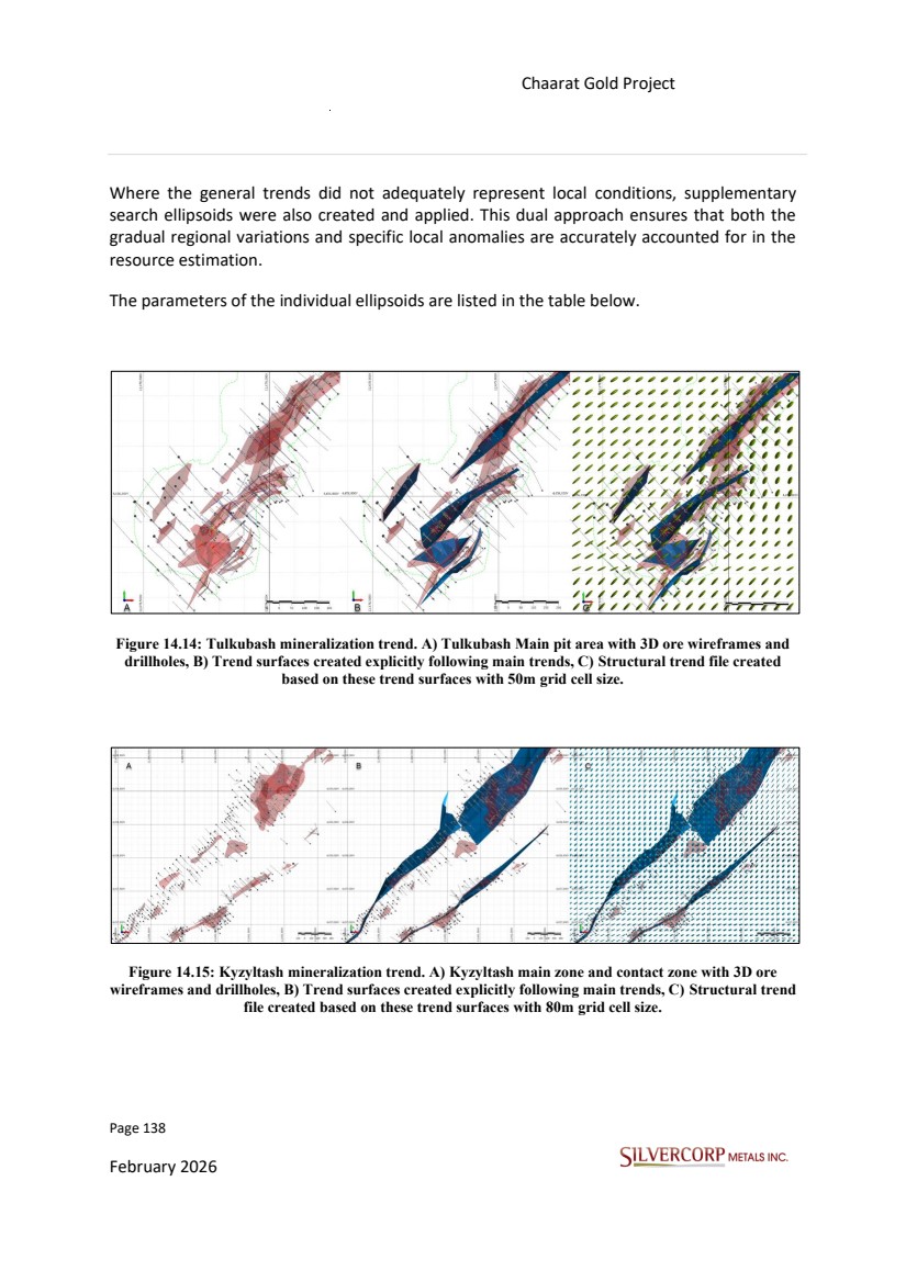
| Page 139 February 2026 Chaarat Gold Project Chatkal district, Kyrgyzstan NI 43-101 Technical Report Mineral Resource Update Table 14.7: Additional Ellipsoids Parameters. Ellipsoid Name Azimuth Plunge Rotation Vein Kyz_N 41.7 0 -18.1 Kyz_15 Kyz_20 Kyz_27 Kyz_S1 25.2 0 -19.4 Kyz_02 Kyz_03 Kyz_04 Kyz_05 Kyz_06 Kyz_18 Kyz_S2 55.9 0 -13 Kyz_01 Kyz_07 Kyz_11 Kyz_12 Kyz_16 Kyz_17 Kyz_S3 50.7 -7.1 10.9 Kyz_13 Kyz_14 Kyz_21 Kyz_22 |
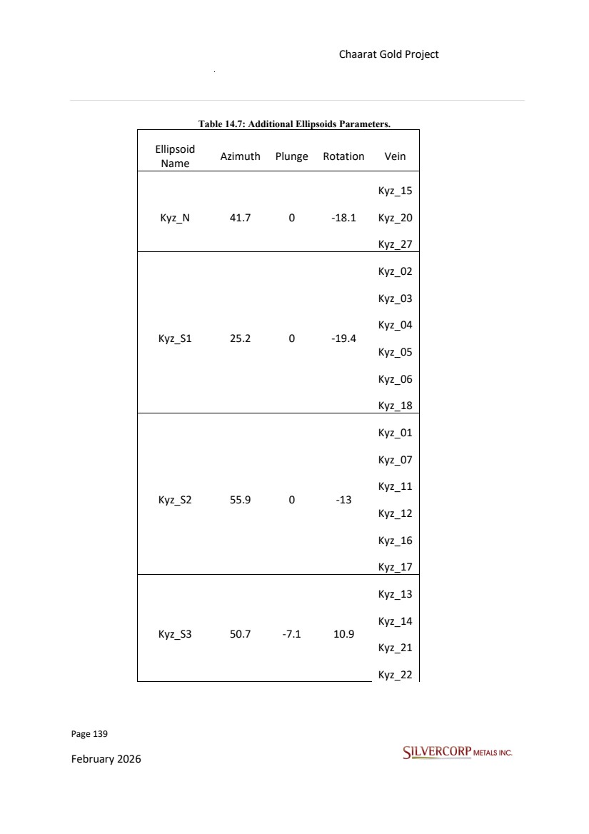
| Page 140 February 2026 Chaarat Gold Project Chatkal district, Kyrgyzstan NI 43-101 Technical Report Mineral Resource Update Kyz_23 Kyz_28 Tul_10 50.9 7.6 -43.9 Tul_10 Tul_14 Tul_N 41.7 0 -18.1 Tul_21 Tul_22 Tul_24 Tul_25 Tul_26 Tul_27 Tul_23 17.5 -31.6 -10.1 Tul_23 The ultimate grade interpolation was done via Inverse Distance Weight (IDW) with inverse power of 2 selected. The interpolation was completed separately for each wireframe within each domain, taking in to account the ore geometry, and gradually increasing the search ellipse size and decreasing the minimal requirements as DH and samples as listed below. |
| Page 141 February 2026 Chaarat Gold Project Chatkal district, Kyrgyzstan NI 43-101 Technical Report Mineral Resource Update Table 14.8: Parameters used for Grade Interpolations. Domain EST. Pass Method Min Sample count Min Hole Max per Quadrant Major Distance All Wireframes 1 IDW2 8 3 5 40 All Wireframes 2 IDW2 4 2 8 80 All Wireframes 3 IDW2 3 1 8 120 A nearest neighbour model was also constructed for gold (Au) using the same search parameters. This model was used as a validation tool and compared against the IDW estimates to assess potential biases. |
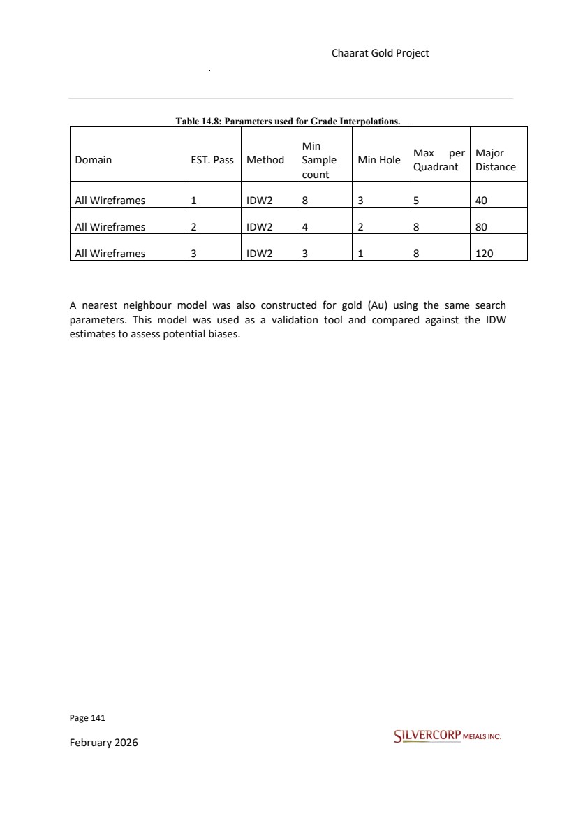
| Page 142 February 2026 Chaarat Gold Project Chatkal district, Kyrgyzstan NI 43-101 Technical Report Mineral Resource Update 14.10. GRADE VALIDATION 14.10.1. Visual Validation A comprehensive graphical validation of the resource block model was undertaken across all estimation domains. This process involved a detailed visual review of cross-sections and plan views directly on the computer screen. Key aspects verified included the alignment of block grades with the underlying composite data, the integrity of the composite data itself, and the overall model's conformance with the topographic surface. No evidence of mis-estimated blocks was identified. Each block grade can be explained as a function of the surrounding composites (Figures 14.16 to 14.19). |
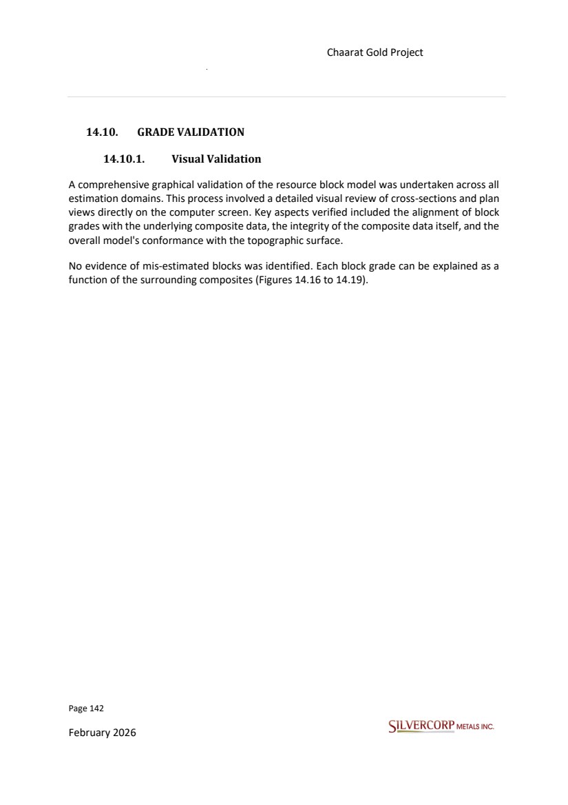
| Page 143 February 2026 Chaarat Gold Project Chatkal district, Kyrgyzstan NI 43-101 Technical Report Mineral Resource Update Figure 14.16: Tulkubash, Au, Main Pit Area (clipping ±20m) Level Plan 2500ml Elevation. |
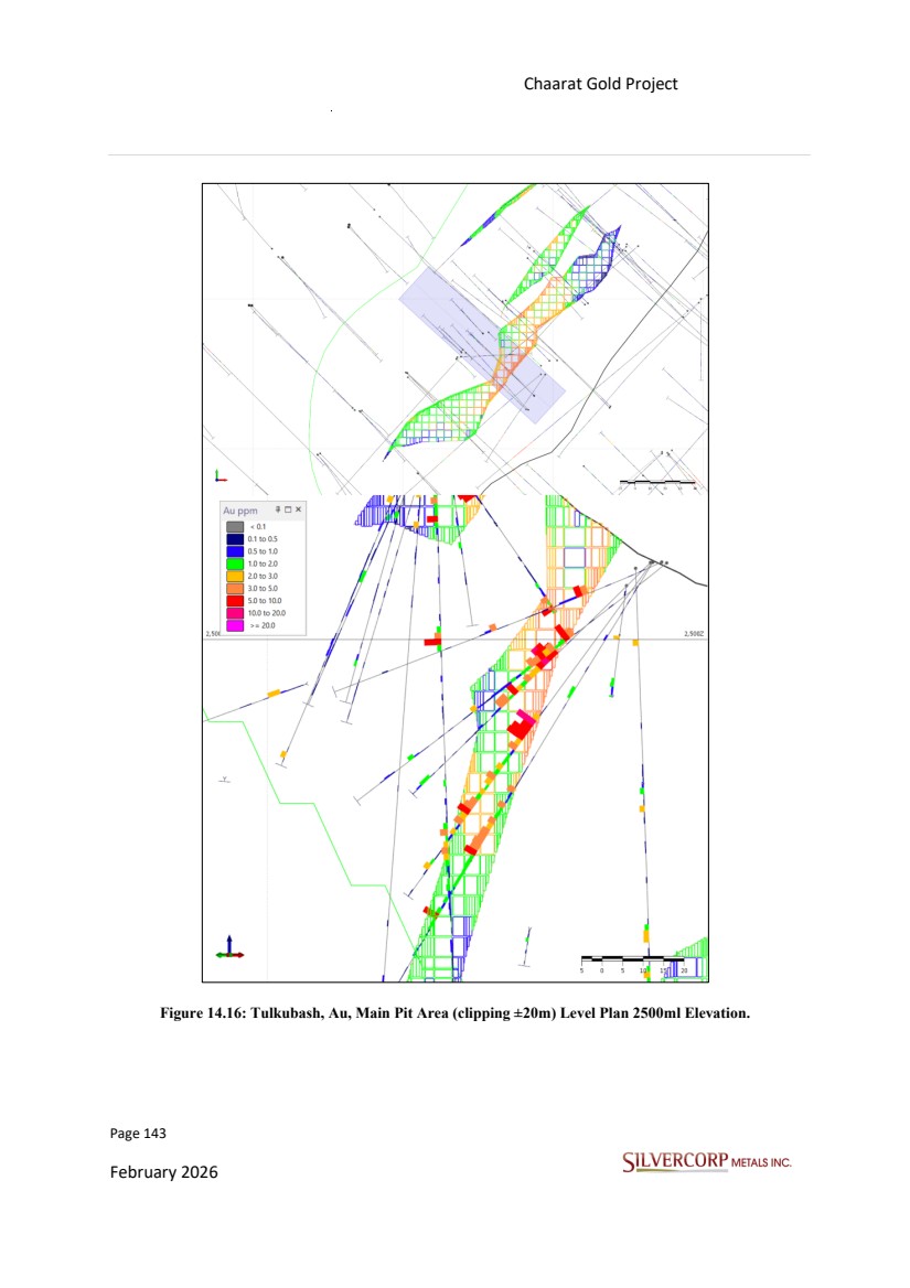
| Page 144 February 2026 Chaarat Gold Project Chatkal district, Kyrgyzstan NI 43-101 Technical Report Mineral Resource Update Figure 14.17: Tulkubash, Au, Main Pit Area (clipping ±15m) long section. |
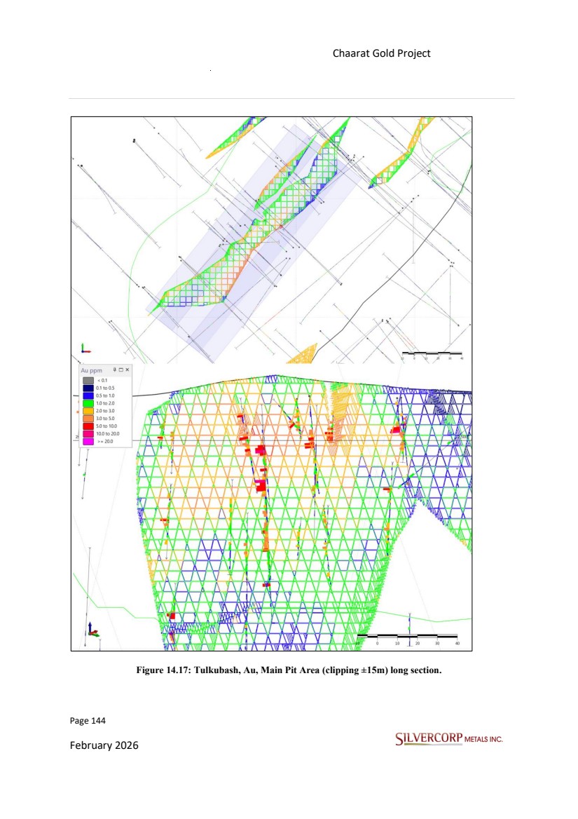
| Page 145 February 2026 Chaarat Gold Project Chatkal district, Kyrgyzstan NI 43-101 Technical Report Mineral Resource Update Figure 14.18: Kyzyltash, Au, Main Zone (clipping ±20m) level plan 2470ml. |
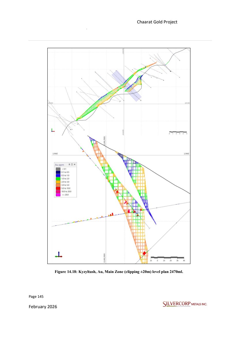
| Page 146 February 2026 Chaarat Gold Project Chatkal district, Kyrgyzstan NI 43-101 Technical Report Mineral Resource Update Figure 14.19: Kyzyltash, Au, contact zone (clipping ±20m) section NE-SW. |
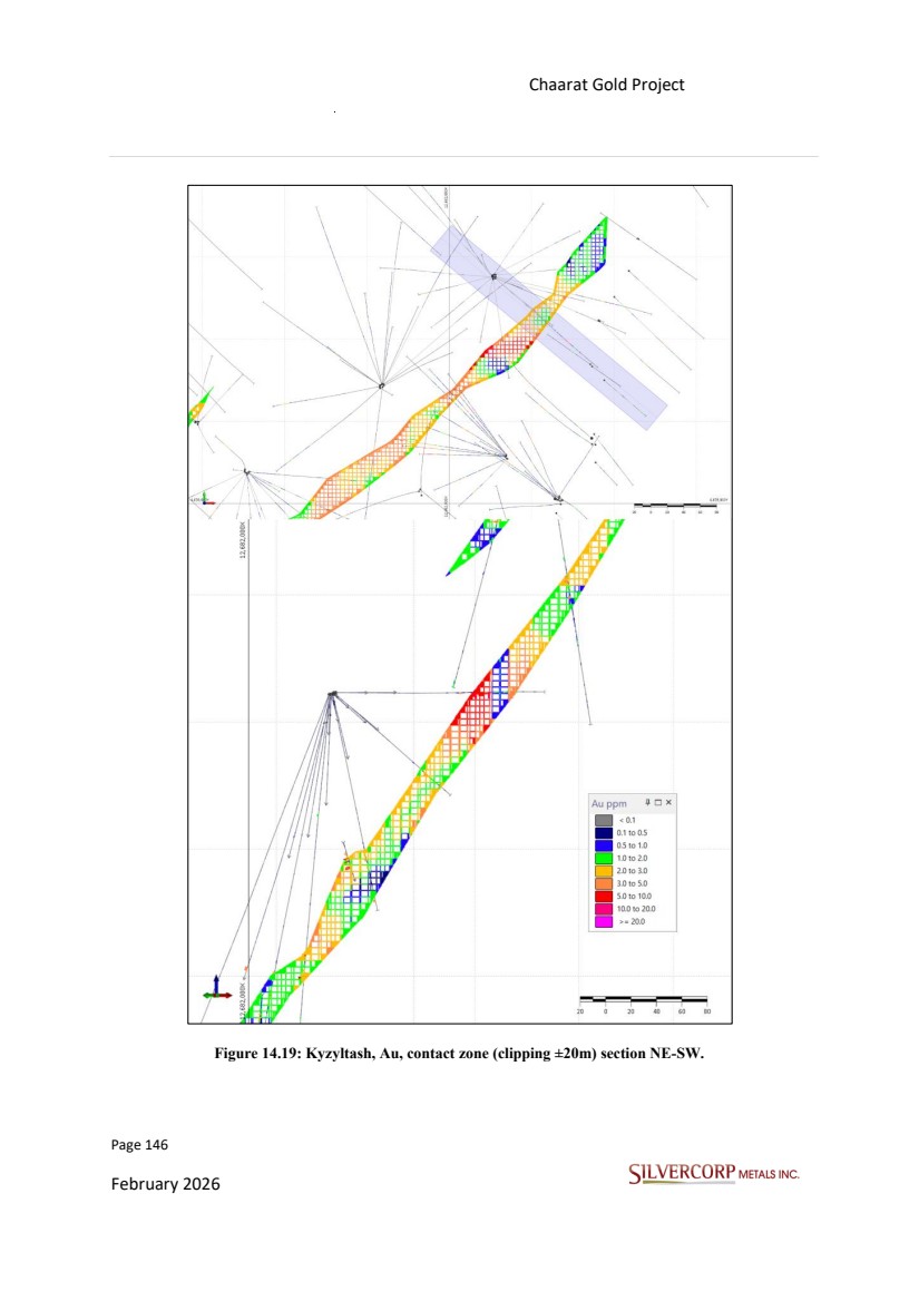
| Page 147 February 2026 Chaarat Gold Project Chatkal district, Kyrgyzstan NI 43-101 Technical Report Mineral Resource Update 14.10.2. Statistical Validation Swath plots were generated as part of the statistical validation of the block model. This analysis provides a robust means of assessing whether the grade interpolation process has preserved the overall grade distribution and trends present in the original composite data, helping to identify any conditional bias or over-smoothing in the model. The swath plot of gold (Au) grade trends comparing the original 1.5m declustered composites with the estimated block grades demonstrate that the block model closely reproduces the grade distribution observed in the original 1.5 m composite grades (Figure 14.20). Figure 14.20: Swath plot, assay composites. |
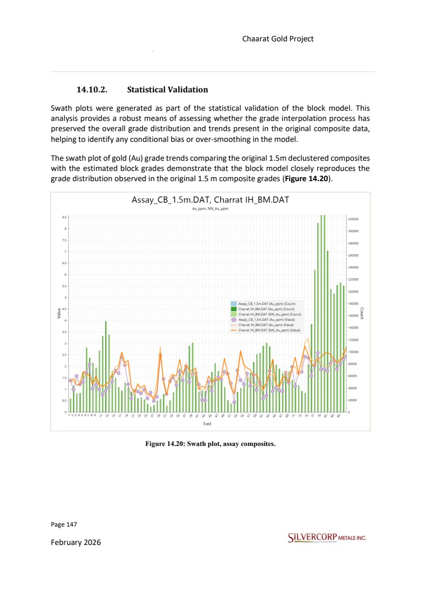
| Page 148 February 2026 Chaarat Gold Project Chatkal district, Kyrgyzstan NI 43-101 Technical Report Mineral Resource Update These and other statistical validation procedures confirm that the block model grade estimates behave as expected, exhibiting appropriate smoothing and no evident anomalous values. The model is globally unbiased and internally consistent with the composite data and correlogram models used in its construction. 14.11. RESOURCE CLASSIFICATION Under the CIM definitions (CIM Definition Standards for Mineral Resources & Mineral Reserves, May 10, 2014), “A Measured Mineral Resource is that part of a Mineral Resource for which quantity, grade or quality, densities, shape, and physical characteristics are estimated with confidence sufficient to allow the application of Modifying Factors to support detailed mine planning and final evaluation of the economic viability of the deposit.” Likewise, “An Indicated Mineral Resource is that part of a Mineral Resource for which quantity, grade or quality, densities, shape and physical characteristics are estimated with sufficient confidence to allow the application of Modifying Factors in sufficient detail to support mine planning and evaluation of the economic viability of the deposit.” Finally, “An Inferred Mineral Resource is that part of a Mineral Resource for which quantity and grade or quality are estimated based on limited geological evidence and sampling. Geological evidence is sufficient to imply but not verify geological and grade or quality continuity.” Resource classification was carried out using a multi-stage approach. Initially, classification was based on fundamental criteria such as drill hole spacing and sample density. Subsequently, additional parameters were introduced to account for increased risk at depth. The criteria used in the first stage of the resource classification process were: 1. Measured blocks have been estimated within a major radius distance of 40m, with a minimum of 8 composites and three drill holes used, and 20 composites maximum defined. 2. Indicated blocks have been estimated within a major radius distance of 80m, with a minimum 4 composites and two drill holes used, and 32 composites maximum defined. 3. Inferred blocks have been estimated within a major radius distance of 120m, with a minimum of 3 composites and one drill hole used, and 40 composites maximum defined. |
| Page 149 February 2026 Chaarat Gold Project Chatkal district, Kyrgyzstan NI 43-101 Technical Report Mineral Resource Update 14.12. MINERAL RESOURCES 14.12.1. Reasonable Prospects of Economic Extraction The estimated Mineral Resources were constrained to a pit shell conducted by Chaarat ZAAV internally using conservative metal prices as the ones used in Chaarat ZAAV’s 2020 MRE. Figure 14.21: Tulkubash Pit shells. Table 14.9: Assumptions for Tulkubash Mineral Resource Estimate. Parameter Tulkubash Value Gold Price (US$/oz) 1800 Silver Price (US$/oz) 21.7 Au Recovery % 71 Ag Recovery % 60 Mining Cost (US$/t) Waste 1.89 Mining Cost (US$/t) Ore 2.73 Processing Cost (US$/t) 4.25 G&A Cost (US$/t) 1.27 Pit slope angles (degrees) Variable by location 45 - 55.5 |
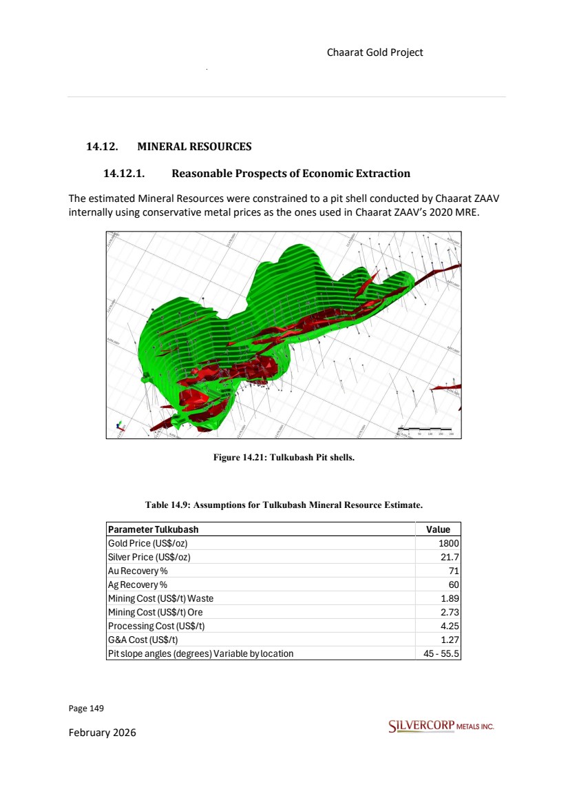
| Page 150 February 2026 Chaarat Gold Project Chatkal district, Kyrgyzstan NI 43-101 Technical Report Mineral Resource Update Kyzyltash gold project is planned to be developed via bulk underground mining methods. It is expected that cut-and-fill (C&F) and / or sublevel open stopping (SLOS) mining methods will be engaged as most suitable for the Kyzyltash ore bodies. The QP evaluated the classified blocks for reasonable prospects of economic extraction by applying preliminary economics parameters consistent with potential open-pit mining methods in the Tulkubash area and underground mining methods in Kyzyltash. This assessment does not constitute a formal economic analysis of the deposit but rather serves to establish reasonable assumptions for the declaration of mineral resources. Table 14.10 Assumptions for Kyzyltash Mineral Resource Estimate SVM evaluated the classified blocks for reasonable prospects of economic extraction by applying preliminary economics parameters consistent with potential mining methods. This assessment does not constitute a formal economic analysis of the deposit but rather serves to establish reasonable assumptions for the declaration of mineral resources. Parameter Kyzyltash Value Gold Price (US$/oz) 1800 Silver Price (US$/oz) 21.7 Au Recovery % (Contact Zone) 88.2 Au Recovery % (Main Zone) 82.2 Ag Recovery % (Contact Zone) 66.1 Ag Recovery % (Maint Zone) 33.4 Mining Cost (US$/t) Cut & Fill 60 Mining Cost (US$/t) Sublevel Stopping 30 Processing Cost (US$/t) CIL 12.5 G&A Cost (US$/t) 2.9 |
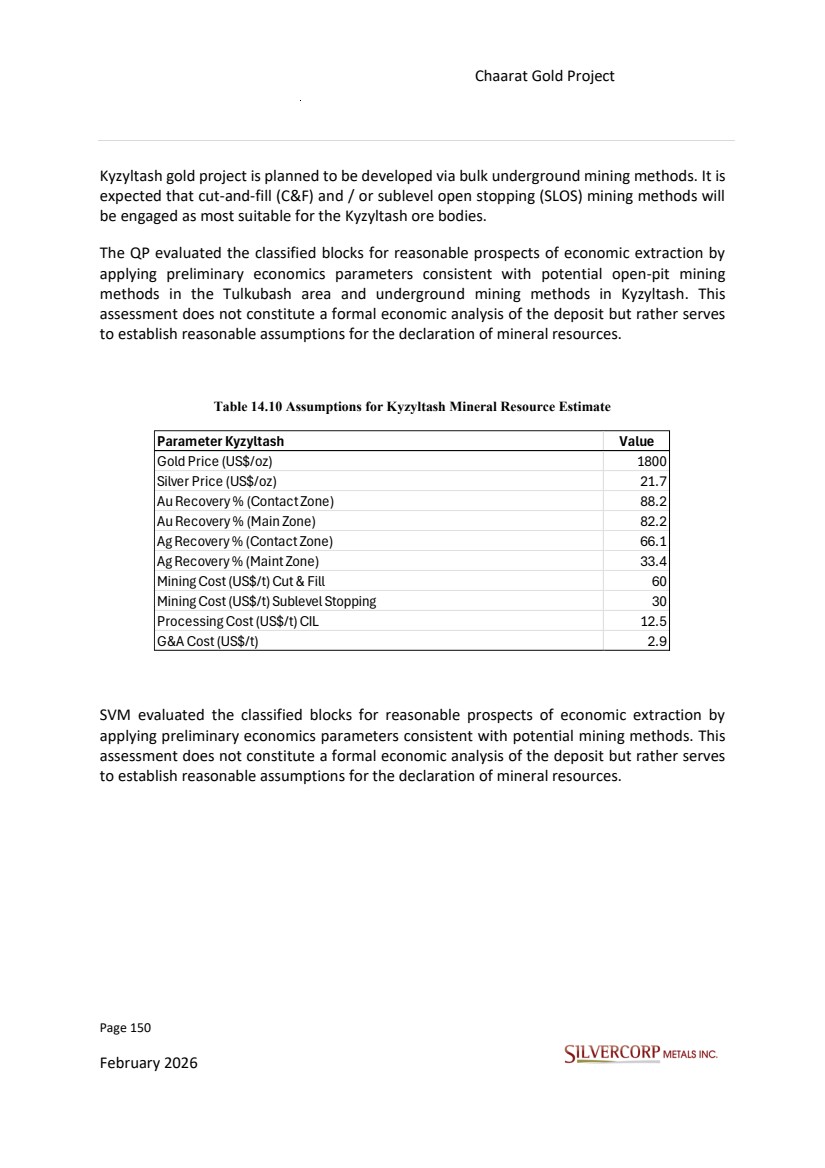
| Page 151 February 2026 Chaarat Gold Project Chatkal district, Kyrgyzstan NI 43-101 Technical Report Mineral Resource Update 14.12.2. Cut-Off Grade Calculation Based on industry practice, material is deemed economically viable for further processing if its contained value exceeds the estimated processing cost. Accordingly, SVM has selected a gold cut-off grade of 0.21 g/t for reporting Mineral Resources at Tulkubash within the conceptual pit shell (Figure 14.21) and 1.0 g/t for reporting underground Mineral Resources at Kyzyltash. Detailed assumptions of parameters were listed in Table 14.9 and 14.10. 14.12.3. Factors That May Affect Mineral Resource Estimate Areas of uncertainty that may materially impact the Mineral Resource estimates include: • Long-term commodity price assumptions. • Long-term exchange rate assumptions. • Operating cost assumptions used. • Metal recovery assumptions used. • Changes to the tonnage and grade estimates as a result of new assay and bulk density information. • Future tonnage and grade estimates may vary significantly as more drilling is completed. • Changes to the metallurgical recovery assumptions as a result of new metallurgical testwork. • Any changes to the slope angle of the pit wall due to geotechnical information would affect the pit shell used to constrain the mineral resources. 14.12.4. Mineral Resource Statement The Mineral Resource estimates of the Tulkubash located in Western Kyrgyzstan, in the southeastern portion of the Sandalash mountain range, northwest of the Sandalash River, in the Chatkal district, Jalal-Abad Oblast of western Kyrgyzstan, approximately 300 km southwest of Bishkek, capital of the Republic of Kyrgyzstan, were prepared following the Canadian Institute of Mining, Metallurgy and Petroleum (CIM) Estimation of Mineral Resources and Mineral Reserves Best Practice Guidelines (CIM, 2019) and reported in accordance with the CIM Definition Standards for Mineral Resources and Mineral Reserves (CIM Definition Standards, 2014). Table 14.10 and Table 14.11 have been rounded to reflect the Mineral Resource estimate is considered an approximation. The current diluted Mineral Resources, which are not mineral |
| Page 152 February 2026 Chaarat Gold Project Chatkal district, Kyrgyzstan NI 43-101 Technical Report Mineral Resource Update reserves, do not demonstrate economic viability at this stage. No Mineral Reserves have been identified to date within the Tulkubash open pit area or the Kyzyltash underground zone. Table 14.10: Tulkubash Mineral Resource Statement. Notes: 1. The effective date of the resource is 15th October 2025. 2. The qualified person (as defined in NI 43-101) for the purposes of the MRE is Lei Xue, P. Geo., Resource Geologist for the Company 3. Grade estimation completed via Inverse Distance Weight method, within block model with a parent block size of 10 m x 10m x 10 m and minimal sub-blocking of 1m. 4. Mineral Resources are constrained by Resource shell defined as per $1,800/oz gold price, applied variable recovery estimations and a cut-off grade 0.21 g/t Au. 5. The Mineral Resources are not Mineral Reserves and do not demonstrate economic viability. 6. Numbers may not sum due to rounding. Category Tonnes (Mt) Au Grade (g/t) Ag Grade (g/t) Contained Au (koz) Contained Ag (koz) Measured 7.35 1.61 1.38 380.5 327.0 Indicated 1.28 1.99 1.45 81.7 59.6 Total M+I 8.63 1.67 1.39 462.2 386.6 Inferred 0.01 1.29 0.58 0.5 0.2 |
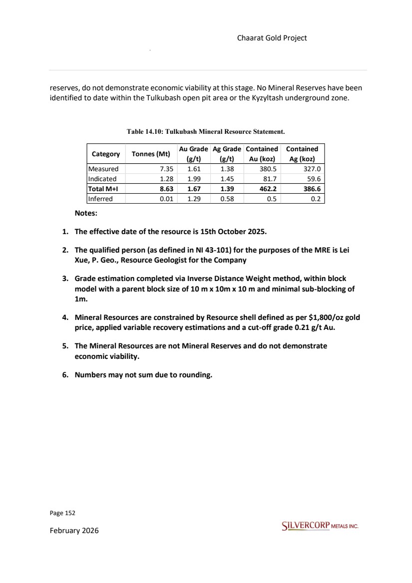
| Page 153 February 2026 Chaarat Gold Project Chatkal district, Kyrgyzstan NI 43-101 Technical Report Mineral Resource Update Table 14.11: Kyzyltash Mineral Resource Statement. Notes: 1. The effective date of the reported Resource is 15th October 2025. 2. The qualified person (as defined in NI 43-101) for the purposes of the MRE is Lei Xue, P. Geo., Resource Geologist for the Company 3. Grade estimation completed via Inverse Distance Weight method, within block model with a parent block size of 10 m x 10 m x 10 m and minimal sub-blocking of 1m. 4. Applied cutoff grade of 1.0 g/t Au. 5. The Mineral Resources are not Mineral Reserves and do not demonstrate economic viability. 6. Numbers may not sum due to rounding. Category Tonnes (Mt) Au Grade (g/t) Ag Grade (g/t) Contained Au (Koz) Contained Ag (Koz) Measured 3.27 2.70 2.58 271.2 836.0 Indicated 47.04 2.76 2.43 3,670.7 13,548.8 Total M+I 50.31 2.69 2.44 3,941.9 14,384.8 Inferred 21.36 2.76 2.30 1,576.8 5,947.9 |
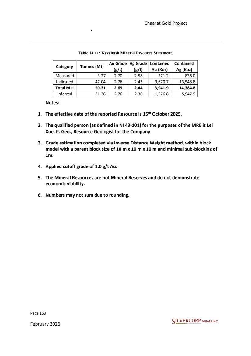
| Page 154 February 2026 Chaarat Gold Project Chatkal district, Kyrgyzstan NI 43-101 Technical Report Mineral Resource Update TECHNICAL REPORT SECTIONS NOT REQUIRED The following sections 15 to 22, which form part of the NI 43-101 reporting requirements for advanced projects or properties, are not relevant to this Technical Report. |
| Page 155 February 2026 Chaarat Gold Project Chatkal district, Kyrgyzstan NI 43-101 Technical Report Mineral Resource Update 15. MINERAL RESERVE ESTIMATES No Mineral Reserves have been estimated. |
| Page 156 February 2026 Chaarat Gold Project Chatkal district, Kyrgyzstan NI 43-101 Technical Report Mineral Resource Update 16. MINING METHODS |
| Page 157 February 2026 Chaarat Gold Project Chatkal district, Kyrgyzstan NI 43-101 Technical Report Mineral Resource Update 17. RECOVERY METHODS |
| Page 158 February 2026 Chaarat Gold Project Chatkal district, Kyrgyzstan NI 43-101 Technical Report Mineral Resource Update 18. PROJECT INFRASTRUCTURE |
| Page 159 February 2026 Chaarat Gold Project Chatkal district, Kyrgyzstan NI 43-101 Technical Report Mineral Resource Update 19. MARKET STUDIES AND CONTRACTS |
| Page 160 February 2026 Chaarat Gold Project Chatkal district, Kyrgyzstan NI 43-101 Technical Report Mineral Resource Update 20. ENVIRONMENTAL STUDIES, PERMITTING AND SOCIAL OR COMMUNITY IMPACT |
| Page 161 February 2026 Chaarat Gold Project Chatkal district, Kyrgyzstan NI 43-101 Technical Report Mineral Resource Update 21. CAPITAL AND OPERATING COSTS |
| Page 162 February 2026 Chaarat Gold Project Chatkal district, Kyrgyzstan NI 43-101 Technical Report Mineral Resource Update 22. ECONOMIC ANALYSIS |
| Page 163 February 2026 Chaarat Gold Project Chatkal district, Kyrgyzstan NI 43-101 Technical Report Mineral Resource Update 23. ADJACENT PROPERTIES The Chaarat Gold Project is located in Western Kyrgyzstan, in the southeastern portion of the Sandalash mountain range, northwest of the Sandalash River, in the Chatkal district, Jalal-Abad Oblast of western Kyrgyzstan, approximately 300 km southwest of Bishkek, capital of the Republic of Kyrgyzstan and hosts a number of large deposits including Muruntau (175 million oz.), Daugyztau (18 million oz.), Zarmitian (11 million oz.) and Kumtor (18 million oz.). Figure 23.1 presents the location of the adjacent mines and some advanced projects with respect to the Chaarat Gold Project. https://www.chaarat.com/ Figures 23.1: Chaarat Project Location in Tien Shan Belt and Mine map The foregoing is provided for informational purposes only based on publicly available information and the QPs have not verified the information related to such adjacent properties and such information is not necessarily indicative of the mineralization on the Chaarat Gold Project which is the subject of this Report. |
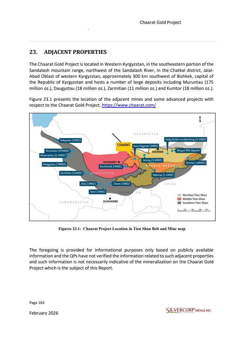
| Page 164 February 2026 Chaarat Gold Project Chatkal district, Kyrgyzstan NI 43-101 Technical Report Mineral Resource Update 24. OTHER RELEVANT DATA AND INFORMATION All relevant data and information regarding the Chaarat Gold Project have been included in other sections of this Technical Report. The QP is unaware of any other data that would make a material difference to the quality of this Technical Report or make it more understandable, or without which the Report would be incomplete or misleading. |
| Page 165 February 2026 Chaarat Gold Project Chatkal district, Kyrgyzstan NI 43-101 Technical Report Mineral Resource Update 25. INTERPRETATION AND CONCLUSIONS 25.1. RISKS AND UNCERTAINTIES Chaarat ZAAV has a well developed system of procedures and protocols that have been implemented, modified and improved over more than twenty-five-years of exploration in the Project. The risks for Tulkubash and Kyzyltash deposits, as identified by the QP, include: • As noted in previous reports, the metallurgical recovery estimates may be negatively impacted by several factors. A key risk is the potential for gold lock-up due to the generation of excessive fine material during processing. Furthermore, the heap leach facility is expected to operate under a broad thermal gradient, with ambient temperatures ranging from +38ºC to –35ºC. Heap leach kinetics are temperature-dependent and are known to decelerate significantly below 7ºC, which may constrain overall production during winter months. • Operational Risks from Geohazards: Site operations may be affected by local geohazards, including rockfalls, avalanches of debris, rock, or snow, and significant water runoff resulting from seasonal snowmelt and storm events. • Regulatory and Tax Uncertainty in the Kyrgyz Republic: A key risk arises from the evolving nature of the Kyrgyz Republic’s tax and regulatory framework, which is subject to frequent legislative changes and may lead to conflicting legal interpretations. This risk is substantially mitigated by a stability agreement between Silvercorp and the Government of the Kyrgyz Republic, which establishes a fixed tax regime for the duration of the project's operations. These factors represent a high level of risk and thus could impact the project's economics. To assist in mitigating the risks, the following recommendation is proposed: • Ongoing refinement of the production schedule -particularly during peak operational periods- should be accompanied by the early implementation of stringent and proactive grade control measures. This approach is essential to ensure the consistent quality of the Run-of-Mine (RoM) ore delivered for processing. |
| Page 166 February 2026 Chaarat Gold Project Chatkal district, Kyrgyzstan NI 43-101 Technical Report Mineral Resource Update • Although existing geotechnical studies have defined the pit slopes, it is recommended to develop a dynamic 3D model of key geotechnical parameters -such as RQD and RMR- based on drill hole data. The application of methods like Multiple Indicator Kriging (MIK) or Gaussian Simulation would enhance the predictive capability of the model across different mining phases, particularly for the Tulkubash deposit. This approach would support performance forecasting in areas of variable rock mass quality, which directly influences slope stability and the generation of fine material. • It is recommended to maintain strong and proactive government relations to facilitate timely approvals for project development and operational activities. Additionally, a strategic gold dore sales plan should be developed to optimize revenue within the framework of the government's purchase rights and applicable royalty agreements. Aside from the comments and potential risks discussed above, the QP is not aware of any other factors -including environmental, permitting, legal, title, taxation, socio-economic, marketing, or political considerations- which could materially affect the exploration data or the exploration potential of the Project as presented in this report. In the opinion of the responsible QP, the following interpretations and conclusions are appropriate to the project's status: • Information from legal experts supports that the mining tenure held is valid and sufficient to support a declaration of Mineral Resources. • There is no awareness of any significant environmental, social or permitting issues that would prevent continued exploitation of the Project deposits. • Knowledge of the deposit settings and lithologies, as well as the structural and alteration controls on mineralization and the mineralization style and setting, is sufficient to support Mineral Resource estimation. • The exploration programs completed to date are appropriate for the style of the deposits and prospects within the Project. The strike extent of presently-known mineralized zones is likely to be extended with additional drilling in areas of subdued topography and under post-mineral cover. Numerous instances of quartz veins and silicified rock with anomalous metal values remain to be thoroughly evaluated in the Project. • The quantity and quality of the lithological, geotechnical, collar and down-hole survey data collected during the exploration and delineation drilling programs are sufficient to support Mineral Resource estimates. The collected sample data adequately reflect deposit dimensions, true widths of mineralization, and the style of the deposits. |
| Page 167 February 2026 Chaarat Gold Project Chatkal district, Kyrgyzstan NI 43-101 Technical Report Mineral Resource Update Sampling is representative of the metal grades in the deposit, reflecting areas of higher and lower grades. • The QA/QC programs adequately address precision, accuracy and contamination issues. Drilling programs typically included blanks, duplicates and CRMs samples. QA/QC submission rates meet industry-accepted standards. The QA/QC programs did not detect any material sample biases. • Factors that may affect the Mineral Resource estimates include metal prices, assumptions used in the pit shell constraining for Open Pit Mineral Resources, and pit slope angle. 25.2. CONCLUSIONS Chaarat ZAAV has a well developed system of procedures and protocols that have been implemented and updated over the company's more than twenty-five history of exploration in the project The future goal is to expand resources by advancing exploration and drilling on prospects with the highest potential and geological evidence, focusing on developing new targets in areas with limited or no previous drilling, particularly to the northeast of Tulkubash and the southwest of Kyzyltash. In conclusion, the forward-looking drilling strategy for the Chaarat gold project should be on a dual approach: significantly increasing the inferred resource inventory and systematically converting inferred resources to the indicated classification. This disciplined methodology is designed to de-risk the project and expand its foundation for future development, ensuring the prudent maximization of asset value. |
| Page 168 February 2026 Chaarat Gold Project Chatkal district, Kyrgyzstan NI 43-101 Technical Report Mineral Resource Update 26. RECOMMENDATIONS 26.1. BUDGET AND PLAN FOR FURTHER WORK Silvercorp has planned extensive exploration programs at the Chaarat property to further delineate and define the resource potential of the property. • Underground exploration tunnels at Contact Zone Underground tunnels were planned for 2300m level and 2500m level for a total of roughly 7800m. These tunnels are designed to be driven through mineralization from the start then become exploration drifts. These exploration tunnels will provide platforms for drilling, with improved access points, more favorable drillhole orientations, and the ability to test targets that are difficult to reach from surface. This program is expected to support extension of the Contact Zone and facilitate the discovery of new mineralized targets, while enabling more cost-effective drilling and accelerating the upgrade of Inferred to Indicated resources in critical areas. |
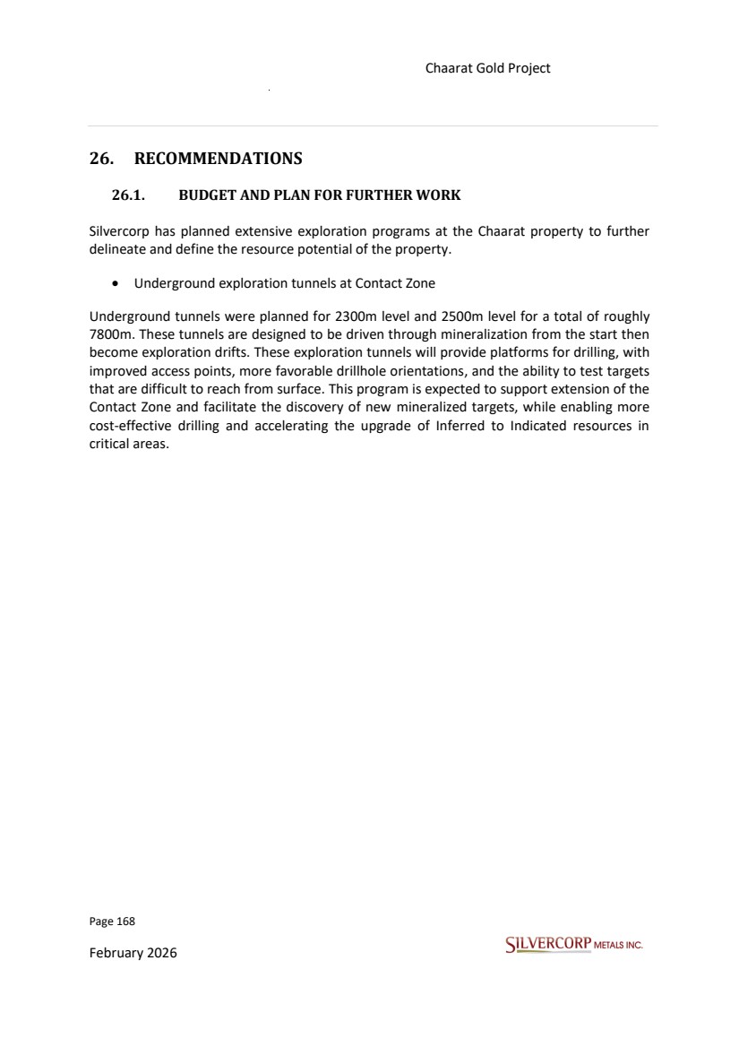
| Page 169 February 2026 Chaarat Gold Project Chatkal district, Kyrgyzstan NI 43-101 Technical Report Mineral Resource Update Figure 26.1 Plan view of planned underground Tunnel for Contact Zone Extension |
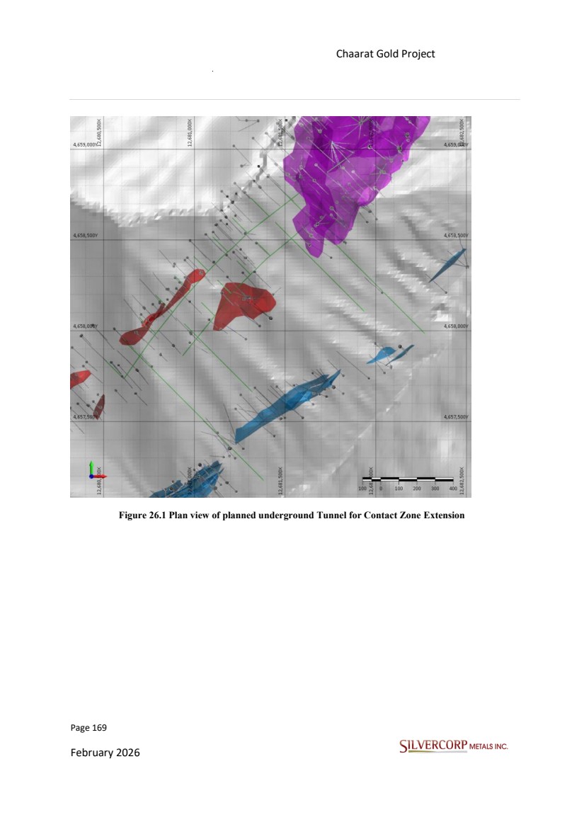
| Page 170 February 2026 Chaarat Gold Project Chatkal district, Kyrgyzstan NI 43-101 Technical Report Mineral Resource Update Figure 26.2 Rotated view of planned underground Tunnel for Contact Zone Extension • Drill Campaigns The 2026 drilling campaign plans to focus on the Kyzyltash sulfide zone, targeting both the Contact Zone (CZ) extension and the Main Zone (MZ). A total of approximately 46,000 meters is planned, potentially executed in two phases, with the objective of achieving a 50 m × 50 m drill spacing. |
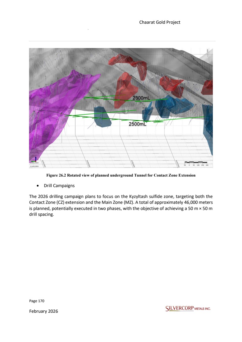
| Page 171 February 2026 Chaarat Gold Project Chatkal district, Kyrgyzstan NI 43-101 Technical Report Mineral Resource Update Figure 26.3 SVM planned drillholes. |
| Page 172 February 2026 Chaarat Gold Project Chatkal district, Kyrgyzstan NI 43-101 Technical Report Mineral Resource Update Figure 26.4 Planned drillholes from underground tunnels, Contact Zone extension. Silvercorp plans to spend US$17,466,00 during Phase I in 2026, which will include access road and drill pad preparation, 20 000 m of diamond core drilling, assays, and 3000 m of development and exploration tunneling. Phase II is planned for 2027 with a preliminary budget of US$26,862,000 which will cover 26,000 m of diamond core drilling, road and site preparation, assays, metallurgical test work on samples collected from the main and contact zones, as well as a planned 4,800 m of development and exploration tunneling. Totals are inclusive of a 10% contingency (Table 26.1). |
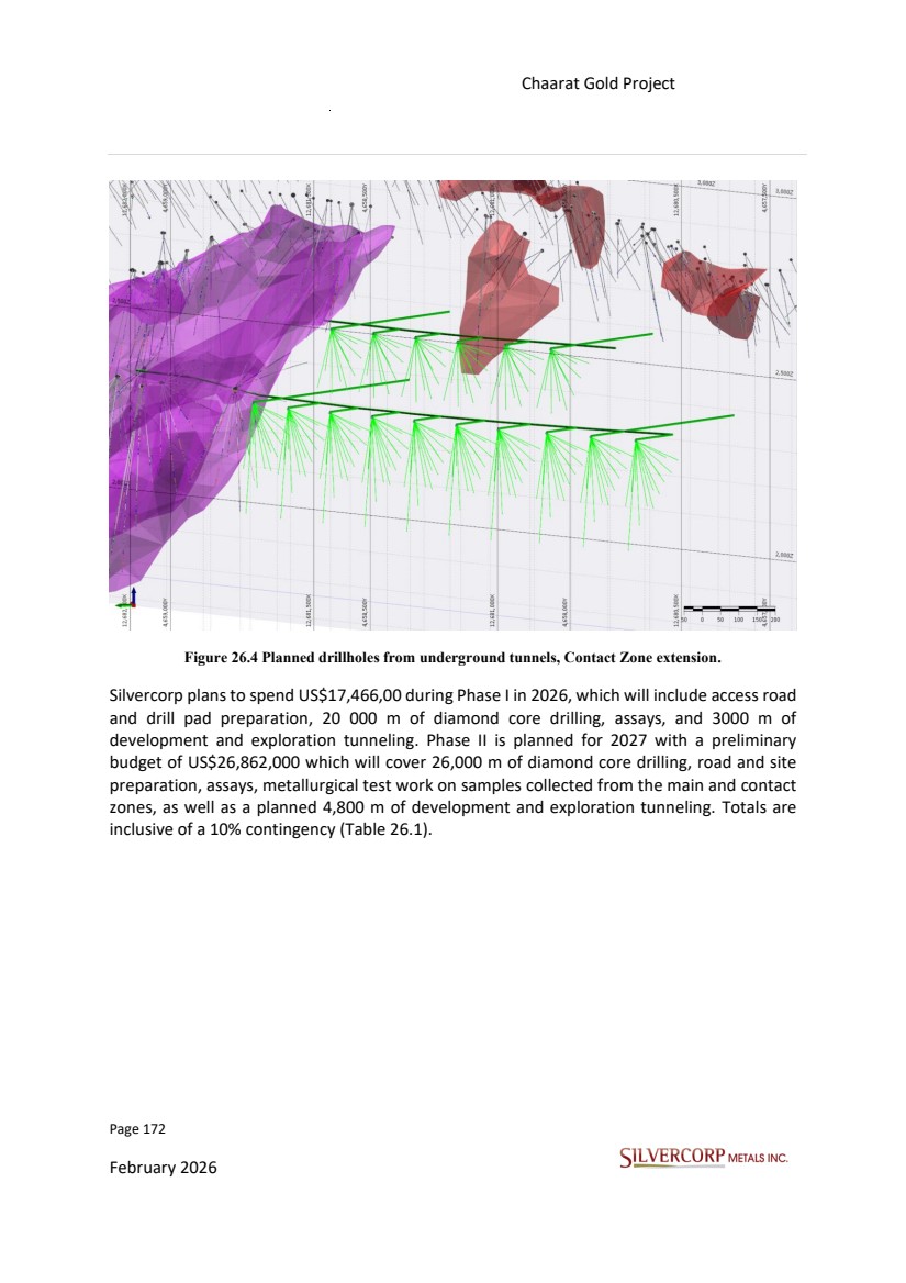
| Page 173 February 2026 Chaarat Gold Project Chatkal district, Kyrgyzstan NI 43-101 Technical Report Mineral Resource Update Table 26.1: Budget for the Exploration of the Chaarat Property 26.2. RECOMMENDATIONS Based on the outcomes of the current Mineral Resource estimate and the development status of the Project, the following recommendations are proposed to advance the projects: • Continue Exploration and Drilling The main objectives for the next drilling campaigns are to increase the Inferred Resources and upgrade current Inferred Resources to Indicated status, while also advancing Indicated Resources to Measured status where feasible. Infill drilling is essential to improve geological confidence and support future reserve definition. Simultaneously, exploration drilling should be considered to test extensions of known mineralization. The future goal is to expand Inferred Resources by advancing exploration in prospects with the highest potential and geological evidence, including developing new targets with no drilling to date or with limited historical development. This dual approach ensures both resource growth and confidence upgrading are systematically pursued. In conclusion, future drilling objectives for the Chaarat Gold Project are centred on significantly increasing Inferred gold resources and converting existing Inferred resources to the Indicated category, with a focus on the Kyzyltash deposit, thereby strengthening the project's resource base for future development opportunities. • Advance Metallurgical Test work Item Phase I 2026 (USD) Phase II 2027 (USD) Total Cost (USD) Roads and drill site preperation $60,000 $80,000 $140,000 Drilling (20,000 m + 26,000 m DDH) $3,400,000 $4,420,000 $7,820,000 Assays $400,000 $520,000 $920,000 Metallurgical testwork $200,000 $200,000 Development tunneling $12,000,000 $19,200,000 $31,200,000 Subtotal $15,860,000 $24,420,000 $40,280,000 Contingency (10%) $1,586,000 $2,442,000 $4,028,000 Total $17,446,000 $26,862,000 $44,308,000 |
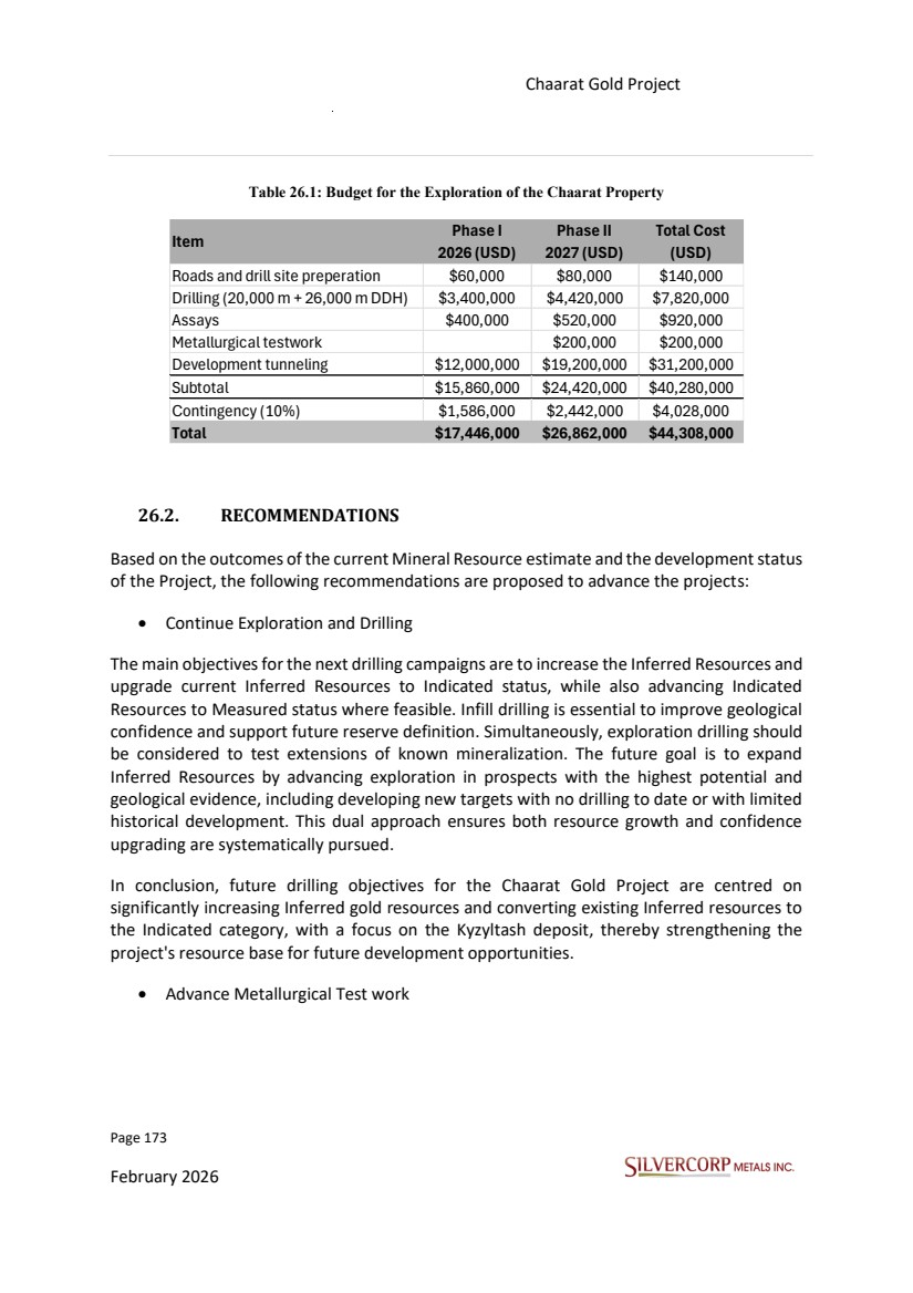
| Page 174 February 2026 Chaarat Gold Project Chatkal district, Kyrgyzstan NI 43-101 Technical Report Mineral Resource Update Metallurgical programs should be further advanced to improve recovery optimization and better define processing parameters. Additional variability testing, particularly on different mineralization styles and domains, is recommended to support flowsheet design and reduce technical risks for both the Tulkubash and Kyzyltash deposits. • Update Economic Assumptions A reassessment of key economic inputs—including metal price assumptions, mining and processing costs, and recoveries—should be undertaken to ensure the Reasonable Prospects for Eventual Economic Extraction (RPEEE) remain valid. Updated assumptions should be integrated into pit optimization and resource reporting to reflect current market conditions. • Refine Geological Modeling Lithological modeling is recommended to support more accurate domaining and grade estimation. This includes integrating new drilling data into updated interpretations, validating lithological controls on mineralization, and improving the understanding of structural settings to enhance future resource models. |
| Page 175 February 2026 Chaarat Gold Project Chatkal district, Kyrgyzstan NI 43-101 Technical Report Mineral Resource Update 27. REFERENCES 27.1. TECHNICAL REPORTS, PAPERS AND OTHER PUBLICATIONS Alden, Andrew. (2012). "Densities of Common Rocks and Minerals." Thought Co, Apr. 5, 2023, http://thoughtco.com/densities-of-common-rocks-and-minerals-1439119 CIM (2014). CIM Definition Standards for Mineral Resources & Mineral Reserves. Canadian Institute of Mining, Metallurgy and Petroleum. Prepared by the CIM Standing Committee on Reserve Definitions Adopted by CIM Council May 19, 2014. pp 1-10. https://mrmr.cim.org/media/1128/cim-definition-standards_2014.pdf CIM (2019). CIM Estimation of Mineral Resources & Mineral Reserves Best Practice Guidelines. Canadian Institute of Mining, Metallurgy and Petroleum. Prepared by the CIM Mineral Resource & Mineral Reserve Committee. Adopted by CIM Council November 29, 2019. pp 1-75. https://mrmr.cim.org/media/1146/cim-mrmr-bp-guidelines_2019_may2022.pdf Deustch, C.V., and Journel, A.G. (1997). GSLIB: A Geostatistical Software Library and User’s Guide, Oxford University Press, New York, 340p., plus CD-ROM. Dimitrov, Dimitar (2022). JORC: Tulkubash Gold Project Resource Estimate. Chaarat Zaav CJSC, April 2022. Dimitrov, Dimitar (2024). JORC: Kyzyltash Gold Project Resource Estimate. Chaarat Zaav CJSC, October 15th, 2024 GSI. (2014). JORC: October 2014 Mineral Resource Update for the Chaarat Gold Project, internal report to Chaarat Gold Holdings Ltd., October 19, 2014. GSI. (2017). JORC: February 2017, Mineral Resource Updates, Tulkubash, Chaarat Gold Project, dated February 5, 2017. Gustavson Associates. (2014). Chaarat Gold Project Resource Estimation, JORC Report”, internal report to Chaarat Gold Holdings Ltd., June 23, 2014. Hirst, Joe. (2020). Tulkubash Recovery Model based on IGT Resource Model, 3rd August 2020, internal report. |
| Page 176 February 2026 Chaarat Gold Project Chatkal district, Kyrgyzstan NI 43-101 Technical Report Mineral Resource Update IGT (2020). Institute of Geotechnologies (IGT) (The Tulkubash Gold Project Mineral Resource Estimate, for Chaarat ZAAV SJSC, Dec. 2020). Isaaks, E.H. (2001). SAGE 2001 Documentation, www.isaaks.com, 68pp, 2001. Isaaks, E.H., and Srivastava, R.M. (1989). An Introduction to Applied Geostatistics, Oxford University Press, 561p, 1989. LogiProc. (2021). Bankable Feasibility Study Update Report, Tulkubash Gold Proejct, Document No.: LP1521-RPT-0001, May 2021, internal report. Patel, S. (2013). “Chaarat Geology and Exploration” Internal company report, Chaarat Gold Holdings Ltd. Rossi, M.E. (2009). Accounting for dilution in ore resource estimation, in APCOM 2009. Vancouver, Canada, 2009, pp. 84-92. Rossi, M.E. and Parker, H.M. (1993). Estimating Recoverable Reserves: Is It Hopeless?, presented at the Forum 'Geostatistics for the Next Century', Montreal, Quebec, Canada, June 3-5, 1993. Rossi, M.E. and Deustch, C.V. (2014). Mineral Resource Estimation, Springer, 332p. SGS. (2022). An Investigation into gold deportment study on two composite samples from the Kyzyltash deposit, Project 18596-01 – Mineralogy Report – Final Report, October 7, 2022. Srivastava, R.M., and Parker, H.M., Robust Measures of Spatial Continuity, in M. Amstrong, Ed., Geostatistics, pp. 295-308, Reidel, Dordrecht, Holland, 1988. Sillitoe, Richard & Hedenquist, Jeffrey. (2003). Linkages between volcanotectonic settings, ore-fluid compositions, and epithermal precious-metal deposits. Tetra Tech. (2014a). Hydrogeologic Testing Report. Technical Memorandum. Doc No. 311409- MEM-R0005-00. Prepared for Marcel DeGuire Chaarat Gold Holdings Ltd. January 2014. Volkov, A.V., 2007, “Model of multilevel structure of ore-columns and conditions of formation of large and superlarge Au-As-Sb disseminated deposits of invisible, refractory gold” Proc. 9th biennial meeting of the Soc. Geol. applied to Mineral deposits, Dublin, pp. 573- 576. Wilkins, A., and Newall, P., March 2012, “Chaarat Project Resource Update”, Final Report, Wardell Armstrong Ltd. |
| Page 177 February 2026 Chaarat Gold Project Chatkal district, Kyrgyzstan NI 43-101 Technical Report Mineral Resource Update 27.2. WEB-BASED SOURCES OF INFORMATION https://www.chaarat.com/ https://hexagon.com/legal https://mrmr.cim.org/media/1128/cim-definition-standards_2014.pdf https://mrmr.cim.org/media/1129/cim-mrmr-bp-guidelines_2019.pdf https://www.newmont.com https://www.barrick.com https://www.patagoniageosciences.com/ |
| Page 178 February 2026 Chaarat Gold Project Chatkal district, Kyrgyzstan NI 43-101 Technical Report Mineral Resource Update CERTIFICATE OF QUALIFIED PERSON Report Date: 26th February 2026. Effective Date: 15th October 2025 I, Lei Xue, P.Geo., do hereby certify: 1. I am currently employed as Resource Geologist with the issuer, Silvercorp Metals Inc., with a business address at Suite 1750 – 1066 West Hastings Street, Vancouver, BC, V6E 3X1, email: leixue@silvercorp.ca 2. I am a graduate of Brandon University with a Bachelor of Science 4-Year Honor Degree. 3. I am a registered Professional Geoscientist (P.Geo.) with the Engineers & Geoscientists British Columbia (EGBC. Licence Number: 47459) with good standing. 4. I have than 15 years’ field experience as a geologist working in mineral exploration and mine geology including mainly gold, silver, and copper deposits in Latin America, North America, Africa, Asia and Australia. My relevant experience for the purpose of the Technical Report includes five years of resource estimation. 5. As a result of my education, professional registration, and relevant experience, I am a "Qualified Person" for purposes of National Instrument 43-101 – Standards of Disclosure for Mineral Projects (NI 43-101). 6. I am responsible for the preparation of Sections 14 of the Technical Report. 7. I have not had prior involvement with the property that is the subject of the Technical Report. 8. I am not independent of the Issuer because I am a full-time employee of the Issuer. 9. I have read NI 43-101 and Form 43-101F1, and the Technical Report has been prepared in compliance with that instrument and form. 10. As of the effective date of the Technical Report, to the best of my knowledge, information, and belief, the Technical Report contains all scientific and technical information that is required to be disclosed to make the Technical Report not misleading. Dated this 26th day of February, 2026. Lei Xue, P.Geo. |
| Page 179 February 2026 Chaarat Gold Project Chatkal district, Kyrgyzstan NI 43-101 Technical Report Mineral Resource Update CERTIFICATE OF QUALIFIED PERSON Report Date: 26th February 2026 Effective Date: 15th October 2025 I, Yongming (Alex) Zhang, P.Geo., do hereby certify: 1. I am a consultant geologist with the issuer, Silvercorp Metals Inc., with a business address at Suite 1750 – 1066 West Hastings Street, Vancouver, BC, V6E 3X1, email: alexzhang@silvercorp.ca; 2. I am a graduate of Queen’s University in Kingston, Ontario, Canada, with a degree of Master of Science in 2002. 3. I am a registered Professional Geoscientist (P.Geo.) in good standing with the Engineers & Geoscientists British Columbia (EGBC. Licence Number: 165192). 4. I have 35 years’ industry experience as a mineral exploration geologist at positions of senior exploration geologist, senior resource geologist, exploration manager, corporate chief geologist and vice president of exploration with exploration and mining companies with base and precious metals projects in Latin America, North America, Africa and Asia. 5. As a result of my education, qualifications and relevant experiences, I am a "Qualified Person" for purposes of National Instrument 43-101 – Standards of Disclosure for Mineral Projects (NI 43-101). 6. I visited Chaarat Project in the period September 11-17, 2025. 7. I am responsible for reviewing matters related to the geological data and the preparation of all sections except Section 14 of the Technical Report. 8. I have not had prior involvement with the property that is the subject of the Technical Report. 9. I am not independent of the Issuer. 10. I have read NI 43-101 and Form 43-101F1, and the Technical Report has been prepared in compliance with that instrument and form. |
| Page 180 February 2026 Chaarat Gold Project Chatkal district, Kyrgyzstan NI 43-101 Technical Report Mineral Resource Update 11. As of the effective date of the Technical Report, to the best of my knowledge, information, and belief, the Technical Report contains all scientific and technical information that is required to be disclosed to make the Technical Report not misleading. Dated this 26th day of February, 2026. [Signature] Yongming (Alex) Zhang, P.Geo. |
| Page 181 February 2026 Chaarat Gold Project Chatkal district, Kyrgyzstan NI 43-101 Technical Report Mineral Resource Update CERTIFICATE OF QUALIFIED PERSON Report Date: 26th February 2026 Effective Date: 15th October 2025 I, Guoliang (Leon) Ma, P.Geo., of Vancouver, British Columbia, do hereby certify that: 1. I am currently employed as a Manager Exploration and Resource with Silvercorp Metals Inc. with an office at Suite 1750-1066 W. Hastings Street, Vancouver, BC V6E 3X1, Canada. 2. This certificate applies to the technical report titled “NI 43-101 Technical Report and Updated Mineral Resource Estimate for the Tulkubash and Kyzyltash Chaarat Gold Project, Republic of Kyrgyzstan” with an effective date of 15 October 2025, (the “Technical Report”) prepared for Silvercorp Metals Inc. (“the Issuer”). 3. I am a graduate of Laval University in Quebec City, Canada (Masters of Science in 2001). I am a member in good standing of the Association of Professional Geoscientists Ontario (License #1967). I have practiced my profession for a total of 30 years. I have experience in the preparation of Resource and Reserve statements, due diligence reviews, and mining and exploration property valuations across a broad range of metalliferous mining projects. 4. I have read the definition of "qualified person" set out in National Instrument 43-101 (NI 43‑101) and certify that by reason of my education, affiliation with a professional association (as defined in NI 43-101) and past relevant work experience, I fulfill the requirements to be a "qualified person" for the purposes of NI 43-101. 5. I have not visited the Chaarat Gold Project. 6. I am responsible for reviewing all sections of the Technical Report and take a general responsible role as “QP” for the report. 7. I am a full-time employee and, therefore, not independent of the Issuer. |
| Page 182 February 2026 Chaarat Gold Project Chatkal district, Kyrgyzstan NI 43-101 Technical Report Mineral Resource Update 8. I have read NI 43-101, and the Technical Report has been prepared in compliance with NI 43‑101 and Form 43-101F1. 9. As of the effective date of the Technical Report and the date of this certificate, to the best of my knowledge, information and belief, this Technical Report contains all scientific and technical information that is required to be disclosed to make the Technical Report not misleading. Dated this 26th day of February, 2026. [Signature] Guoliang Ma, P.Geo. Email:leon@silvercorp.ca |
| Page 183 February 2026 Chaarat Gold Project Chatkal district, Kyrgyzstan NI 43-101 Technical Report Mineral Resource Update APPENDIX 1 GLOSSARY OF MINING AND OTHER RELATED TERMS A Ag: Silver. Anomaly: something that deviates from what is standard or expected. Assay: a chemical test is performed on a sample of ores or minerals to determine the amount of valuable metals. As: Arsenic Au: Gold. Anomaly: something that deviates from what is standard or expected. B Base metal: any non-precious metal (e.g., copper, lead, zinc, nickel, etc.). Bulk sample: a large sample of mineralized rock, frequently hundreds of tonnes, selected in such a manner as to be representative of the potential orebody being sampled. The sample is usually used to determine metallurgical characteristics. C Cateo: exploration concession. Channel sample: a sample composed of pieces of vein or mineralization that have been cut out of a small trench or channel, usually about 10 cm wide and 2 cm deep. Chip sample: a method of sampling a rock exposure whereby a regular series of small chips of rock is broken off along a line across the face. |
| Page 184 February 2026 Chaarat Gold Project Chatkal district, Kyrgyzstan NI 43-101 Technical Report Mineral Resource Update CIM Standards: the CIM Definition Standards on Mineral Resources and Mineral Reserves adopted by CIM Council from time to time. The most recent update adopted by the CIM Council is effective as of 27th November 2010. Contact: a geological term used to describe the line or plane along which two different rock formations meet. Core: the long cylindrical piece of rock, about an inch in diameter, was brought to the surface by diamond drilling. Core sample: one or several pieces of whole or split parts of core selected as a sample for analysis or assay. Cut-off grade: the lowest grade of mineralized rock that qualifies as ore grade in a given deposit is also used as the lowest grade below which the mineralized rock currently cannot be profitably exploited. Cut-off grades vary between deposits depending upon the ore's amenability to gold extraction and production costs. D Deposit: an informal term for an accumulation of mineralization or other valuable Earth material of any origin. Dilution: the inclusion of rock containing little or no economic mineralization that, by necessity, is extracted along with the mineralized material in the mining process, subsequently lowering the overall grade of the mined material. |
| Page 185 February 2026 Chaarat Gold Project Chatkal district, Kyrgyzstan NI 43-101 Technical Report Mineral Resource Update Dip: the angle at which a vein, structure or rock bed is inclined from the horizontal as measured at right angles to the strike. E Epithermal: hydrothermal mineralization formed within one kilometre of the Earth’s surface, in the temperature range of 50º to 200ºC. Epithermal deposit: a mineral deposit consisting of veins and replacement bodies, usually in volcanic or sedimentary rocks, containing precious metals or, more rarely, base metals. Exploration: prospecting, sampling, mapping, diamond drilling and other work involved in searching for ore. F Fault: a break in the Earth's crust caused by tectonic forces which have moved the rock from one side to the other. Fracture: a break in the rock, the opening of which allows mineral-bearing solutions to enter. A "cross-fracture" is a minor break extending at more or less right angles to the direction of the principal fractures. Flotation: a milling process in which valuable mineral particles are induced to become attached to bubbles and float as others sink. |
| Page 186 February 2026 Chaarat Gold Project Chatkal district, Kyrgyzstan NI 43-101 Technical Report Mineral Resource Update G Grade: a term used to indicate the concentration of an economically desirable mineral or element in its host rock as a function of its relative mass. With gold, this term may be expressed as grams per tonne (gpt) or ounces per tonne (oz/t). Gram: one gram is equal to 0.0321507 troy ounces. H Hanging wall: the rock on the upper side of a vein or mineralization. High grade: rich mineralization or ore. As a verb, it refers to selective mining of the best ore in a deposit. Host rock: wall (surrounding) rock that confines the mineral occurrence zone. Hydrothermal: about or related to heated or superheated water deposition of minerals often associated with hot solutions produced by cooling magma. I Igneous rock: a rock formed by the solidification of magma. Indicated Mineral Resource: an Indicated Mineral Resource is that part of a Mineral Resource for which quantity, grade or quality, densities, shape and physical characteristics are estimated with sufficient confidence to allow the application of Modifying Factors in sufficient detail to support mine planning and evaluation of the economic viability of the deposit. |
| Page 187 February 2026 Chaarat Gold Project Chatkal district, Kyrgyzstan NI 43-101 Technical Report Mineral Resource Update Geological evidence is derived from the adequately detailed and reliable exploration, sampling and testing and is sufficient to assume geological and grade or quality continuity between observation points. An Indicated Mineral Resource has a lower confidence level than that applying to a Measured Mineral Resource and may only be converted to a Probable Mineral Reserve. Inferred Mineral Resource: an Inferred Mineral Resource is a part of a Mineral Resource for which quantity and grade or quality are estimated based on limited geological evidence and sampling. Geological evidence is sufficient to imply but not verify geological and grade or quality continuity. An Inferred Mineral Resource has a lower confidence level than that applying to an Indicated Mineral Resource and must not be converted to a Mineral Reserve. It is reasonably expected that most Inferred Mineral Resources could be upgraded to Indicated Mineral Resources with continued exploration. Intrusion / Intrusive: a body of igneous rock that invades older rock. The invading rock may be a plastic solid or magma that pushes its way into the older rock. L Leaching: the separation, selective removal or dissolving-out of soluble constituents from a rock or ore body by the natural actions of percolating solutions. M Magmatic: consisting of, relating to or of magma origin. Magmatism: emplacement of magma within and/or on the surface of crustal rocks by igneous activity. Volcanism is the surface expression of magmatism. Measured Mineral Resource: a Measured Mineral Resource is part of a Mineral Resource for which quantity, grade or quality, densities, shape, and physical characteristics are estimated |
| Page 188 February 2026 Chaarat Gold Project Chatkal district, Kyrgyzstan NI 43-101 Technical Report Mineral Resource Update with confidence sufficient to allow the application of Modifying Factors to support detailed mine planning and final evaluation of the economic viability of the deposit. Geological evidence is derived from detailed and reliable exploration, sampling and testing and is sufficient to confirm geological and grade or quality continuity between observation points. A Measured Mineral Resource has a higher level of confidence than applying either an Indicated Mineral Resource or an Inferred. Mineral Resource. It may be converted to a Proven Mineral Reserve or a Probable Mineral Reserve. Mesothermal: hydrothermal mineralization formed within one kilometre of the Earth’s surface, in the temperature range of 200º to 300ºC. Mine: a mineral mining enterprise. The term is often used to refer to an underground mine. Mineral: a naturally occurring homogeneous substance that has definite physical properties and chemical composition and, if formed under favourable conditions, a definite crystal form. Mineral concession: that portion of public mineral lands which a party has staked or marked out following federal or state mining laws to acquire the right to explore for and exploit the minerals under the surface. Mineral deposit: a body of mineralization that represents a concentration of valuable metals. The limits can be defined by geological contacts or assay cut-off grade criteria. Mineralization: the processes by which minerals are introduced into a rock, resulting in a valuable or potentially valuable deposit. Mineral Resource: a Mineral Resource is a concentration or occurrence of solid material of economic interest in or on the Earth’s crust in such form, grade or quality and quantity that there are reasonable prospects for eventual economic extraction. The location, quantity, |
| Page 189 February 2026 Chaarat Gold Project Chatkal district, Kyrgyzstan NI 43-101 Technical Report Mineral Resource Update grade or quality, continuity and other geological characteristics of a Mineral Resource are known, estimated or interpreted from specific geological evidence and knowledge, including sampling. Mineral Resources are sub-divided to increase geological confidence into Inferred, Indicated and Measured categories. An Inferred Mineral Resource has a lower level of confidence than that applied to an Indicated Mineral Resource. An Indicated Mineral Resource has a higher level of confidence than an Inferred Mineral Resource but has a lower level of confidence than a Measured Mineral Resource. The term mineral resource used in this report is a Canadian mining term defined by NI 43-101. Standards of Disclosure for Mineral Projects under the guidelines set out in the Canadian Institute of Mining, Metallurgy and Petroleum (the CIM), Standards on Mineral Resource and Mineral Reserves Definitions and guidelines adopted by the CIM Council on December 11, 2005, updated as of 27th November 2010, and more recently updated as of 10th May 2014 (the CIM Standards). N Net Smelter Return: a payment made by a producer of metals based on the value of the gross metal production from the property, less deduction of certain limited costs including smelting, refining, transportation and insurance costs. NI 43-101: National Instrument 43-101 is a national instrument for Canada's Standards of Disclosure for Mineral Projects. The Instrument is a codified set of rules and guidelines for reporting and displaying information related to mineral properties owned by, or explored by, companies that report these results on stock exchanges within Canada. This includes foreign-owned mining entities that trade on stock exchanges overseen by the Canadian Securities Administrators (CSA), even if they only trade on Over Counter (OTC) derivatives or other instrumented securities. The NI 43-101 rules and guidelines were updated as of 30th June 2011. O Orebody: a natural accumulation of ore confined to a certain structural and geological element or a combination of such elements. |
| Page 190 February 2026 Chaarat Gold Project Chatkal district, Kyrgyzstan NI 43-101 Technical Report Mineral Resource Update Outcrop: an exposure of rock or mineralization can be seen on the surface that is not covered by soil or water. Oxidation: a chemical reaction caused by exposure to oxygen that results in a change in the chemical composition of a mineral. Ounce: a measure of weight in gold and other precious metals, correctly troy ounces, which weighs 31.2 grams as distinct from an imperial ounce which weighs 28.4 grams. Q QA/QC procedures: those systematic procedures that are used to validate the control and testing of samples in a specified manner. Qualified Person: conforms to that definition under NI 43-101 for an individual: (a) to be an engineer or geoscientist with a university degree, or equivalent accreditation, in an area of geoscience, or engineering, related to mineral exploration or mining; (b) has at least five years' experience in mineral exploration, mine development or operation or mineral project assessment, or any combination of these, that is relevant to his or her professional degree or area of practice; (c)to have experience relevant to the subject matter of the mineral project and the technical report; (d) is in good standing with a professional association; and (e) in the case of a professional association in a foreign jurisdiction, has a membership designation that (i) requires the attainment of a position of responsibility in their profession that requires the exercise of independent judgement; and (ii) requires (A.) a favourable confidential peer evaluation of the individual’s character, professional judgement, experience, and ethical fitness; or (B.) a recommendation for membership by at least two peers, and demonstrated prominence or expertise in the field of mineral exploration or mining. R |
| Page 191 February 2026 Chaarat Gold Project Chatkal district, Kyrgyzstan NI 43-101 Technical Report Mineral Resource Update Representative sample: sample(s) selected to effectively capture specific chemical or physical attributes such as grade, mineralogy, hardness for domains, metallurgical units, or designated portions of a mineral deposit. S Sampling: the process of studying the qualitative and quantitative composition and properties of natural formations comprising a deposit. Sampling protocol: those procedures that describe how sampling is performed and to what level of diligence. Sample selection and collection: the procedure that shows how and why certain samples were collected as being representative. Satellite imagery: high resolution pictures taken from satellites to identify geological features including structures, faults, cross faults, and linear features. Sb: Antimony Sedimentary rock: rock formed by sedimentation of substances in water, less often from the air and due to glacial actions on the land surface and within sea and ocean basins. Sedimentation can be mechanical (under the influence of gravity or environment dynamics changes), chemical (from water solutions upon their reaching saturation concentrations and as a result of exchange reactions), or biogenic (under the influence of biological activity). Stockwork: a complex system of structurally controlled or randomly oriented veinlets. |
| Page 192 February 2026 Chaarat Gold Project Chatkal district, Kyrgyzstan NI 43-101 Technical Report Mineral Resource Update Sulphides: a group of minerals containing sulphur and other metallic elements such as copper and zinc. Gold and silver are often associated with sulphide enrichment mineralization. T Trenching: in geological exploration, a narrow, shallow ditch is cut across a mineral showing or deposits to obtain samples or to observe character. Tonne: a metric ton of 1,000 kilograms (2,205 pounds). V Vein: tabular geological body formed as a result of mineral substance filling a fracture or due to metasomatic replacement of rock with mineral(s) along a fracture. Unlike dykes formed primarily by magmatic rock, a vein is composed of vein and ore minerals (quartz, carbonated, sulphides, etc.). Veinlet: a small vein. W Wall rocks: rock units on either side of a body of mineralization forming the hanging wall and footwall rocks. Waste: unmineralized, or sometimes mineralized, rock that is not minable at a profit. |
| Page 193 February 2026 Chaarat Gold Project Chatkal district, Kyrgyzstan NI 43-101 Technical Report Mineral Resource Update Z Zone: an area of distinct mineralization. |
| Page 194 February 2026 Chaarat Gold Project Chatkal district, Kyrgyzstan NI 43-101 Technical Report Mineral Resource Update APPENDIX 2 |
| Page 195 February 2026 Chaarat Gold Project Chatkal district, Kyrgyzstan NI 43-101 Technical Report Mineral Resource Update |
| Page 196 February 2026 Chaarat Gold Project Chatkal district, Kyrgyzstan NI 43-101 Technical Report Mineral Resource Update |
| Page 197 February 2026 Chaarat Gold Project Chatkal district, Kyrgyzstan NI 43-101 Technical Report Mineral Resource Update |
| Page 198 February 2026 Chaarat Gold Project Chatkal district, Kyrgyzstan NI 43-101 Technical Report Mineral Resource Update APPENDIX 3 Tulkubash, globally unrestricted-undiluted COG VOLUME TONNES SG Au_ppm Au_Ozs Ag_ppm Ag_Ozs Sb_ppm As_ppm Class 0.00 4,677,618 12,579,874 2.69 1.44 583,521 1.32 532,508 1,263 825 Measured 0.21 4,544,759 12,218,835 2.69 1.48 582,009 1.34 528,320 1,299 843 Measured 0.25 4,513,542 12,133,970 2.69 1.49 581,380 1.35 526,810 1,308 846 Measured 0.50 4,219,513 11,334,905 2.69 1.57 571,293 1.40 508,559 1,388 871 Measured 0.75 3,648,283 9,785,705 2.68 1.72 539,765 1.46 459,254 1,546 914 Measured 1.00 2,935,122 7,861,741 2.68 1.92 485,679 1.55 390,819 1,750 977 Measured 1.20 2,401,816 6,429,400 2.68 2.10 435,030 1.60 331,123 1,892 1,030 Measured 1.50 1,701,225 4,553,308 2.68 2.42 353,990 1.69 247,734 2,123 1,129 Measured 2.00 883,497 2,366,325 2.68 3.06 232,426 1.67 127,032 2,145 1,323 Measured 2.50 493,707 1,322,168 2.68 3.72 158,104 1.62 68,779 2,124 1,516 Measured 3.00 286,865 768,866 2.68 4.43 109,564 1.68 41,460 2,435 1,736 Measured COG VOLUME TONNES SG Au_ppm Au_Ozs Ag_ppm Ag_Ozs Sb_ppm As_ppm Class 0.00 1,227,475 3,303,220 2.69 1.52 161,035 1.25 132,492 893 764 Indicated 0.21 1,218,457 3,279,072 2.69 1.53 160,915 1.25 131,544 899 767 Indicated 0.25 1,214,662 3,268,971 2.69 1.53 160,840 1.25 131,140 901 768 Indicated 0.50 1,166,314 3,139,040 2.69 1.58 159,140 1.26 126,782 917 779 Indicated 0.75 1,013,474 2,725,069 2.69 1.72 150,598 1.31 115,158 996 812 Indicated 1.00 792,744 2,125,770 2.68 1.96 133,771 1.38 94,314 1,095 858 Indicated 1.20 638,141 1,709,825 2.68 2.17 119,117 1.35 74,169 1,105 898 Indicated 1.50 481,407 1,289,140 2.68 2.44 100,999 1.28 53,078 1,065 908 Indicated 2.00 266,651 714,269 2.68 3.01 69,153 1.15 26,494 862 900 Indicated 2.50 159,817 430,065 2.69 3.54 48,914 1.15 15,931 860 880 Indicated 3.00 93,792 252,883 2.70 4.10 33,323 1.22 9,947 789 928 Indicated COG VOLUME TONNES SG Au_ppm Au_Ozs Ag_ppm Ag_Ozs Sb_ppm As_ppm Class 0.00 39,182 107,610 2.75 1.28 4,413 0.60 2,079 1,659 403 Inferred 0.21 39,182 107,610 2.75 1.28 4,413 0.60 2,079 1,659 403 Inferred 0.25 39,182 107,610 2.75 1.28 4,413 0.60 2,079 1,659 403 Inferred 0.50 38,256 105,212 2.75 1.30 4,382 0.60 2,037 1,692 402 Inferred 0.75 35,320 97,002 2.75 1.35 4,204 0.60 1,880 1,530 421 Inferred 1.00 28,427 77,896 2.74 1.46 3,660 0.59 1,488 1,160 415 Inferred 1.20 16,012 43,856 2.74 1.73 2,444 0.59 827 801 421 Inferred 1.50 8,383 23,031 2.75 2.12 1,566 0.58 430 566 492 Inferred 2.00 4,210 11,616 2.76 2.49 929 0.67 249 552 563 Inferred 2.50 1,330 3,699 2.78 2.99 355 1.03 123 513 957 Inferred 3.00 422 1,158 2.74 3.58 133 1.87 70 598 1,117 Inferred |
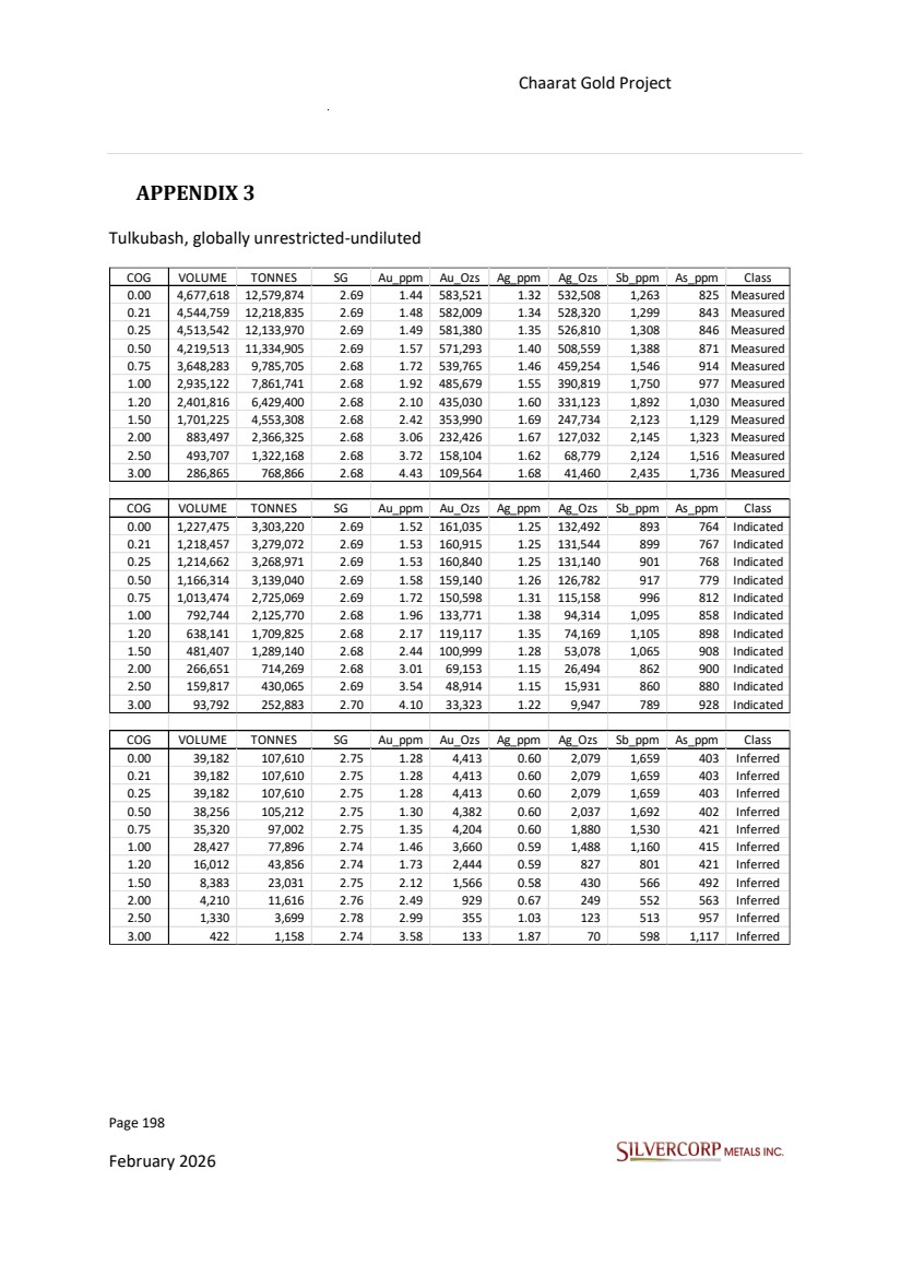
| Page 199 February 2026 Chaarat Gold Project Chatkal district, Kyrgyzstan NI 43-101 Technical Report Mineral Resource Update Kyzyltash, globally unrestricted-undiluted COG VOLUME TONNES SG Au_ppm Au_Ozs Ag_ppm Ag_Ozs Sb_ppm As_ppm Class - 2,487,600 6,662,706 2.68 1.45 311,375 4.46 955,836 735 4,456 Measured 0.21 1,976,075 5,310,188 2.69 1.80 307,380 5.45 930,800 892 5,437 Measured 0.25 1,913,058 5,143,761 2.69 1.85 306,146 5.61 927,066 914 5,574 Measured 0.50 1,620,478 4,364,612 2.69 2.12 297,016 6.43 901,947 1,040 6,251 Measured 0.75 1,397,539 3,768,098 2.70 2.35 285,073 7.21 873,089 1,150 6,782 Measured 1.00 1,213,098 3,274,584 2.70 2.58 271,230 7.94 836,002 1,256 7,299 Measured 1.20 1,091,439 2,949,580 2.70 2.74 259,765 8.44 800,521 1,318 7,666 Measured 1.50 908,097 2,457,713 2.71 3.02 238,413 9.26 731,501 1,398 8,255 Measured 2.00 653,597 1,772,366 2.71 3.51 200,006 10.54 600,817 1,472 9,218 Measured 2.50 460,719 1,250,807 2.71 4.04 162,435 11.96 480,772 1,483 10,057 Measured 3.00 332,211 902,581 2.72 4.54 131,810 13.06 378,997 1,467 10,802 Measured COG VOLUME TONNES SG Au_ppm Au_Ozs Ag_ppm Ag_Ozs Sb_ppm As_ppm Class - 26,191,029 71,531,989 2.73 1.75 4,021,604 6.37 14,642,935 842 5,037 Indicated 0.21 23,502,758 64,402,521 2.74 1.93 3,998,695 7.01 14,505,851 922 5,552 Indicated 0.25 23,067,830 63,255,667 2.74 1.96 3,990,213 7.12 14,477,726 936 5,636 Indicated 0.50 20,857,547 57,388,642 2.75 2.12 3,920,209 7.75 14,294,172 1,008 6,067 Indicated 0.75 18,936,549 52,212,365 2.76 2.27 3,816,396 8.35 14,009,358 1,069 6,426 Indicated 1.00 17,038,098 47,039,086 2.76 2.43 3,670,652 8.96 13,548,771 1,130 6,768 Indicated 1.20 15,485,296 42,775,304 2.76 2.56 3,519,672 9.43 12,975,501 1,183 7,038 Indicated 1.50 12,974,494 35,847,758 2.76 2.79 3,218,655 10.14 11,688,586 1,263 7,487 Indicated 2.00 9,199,968 25,421,724 2.76 3.22 2,634,243 11.31 9,247,080 1,336 8,226 Indicated 2.50 6,052,104 16,728,700 2.76 3.74 2,009,451 12.40 6,669,256 1,461 8,921 Indicated 3.00 3,987,483 11,015,697 2.76 4.26 1,507,255 13.42 4,753,618 1,526 9,531 Indicated COG VOLUME TONNES SG Au_ppm Au_Ozs Ag_ppm Ag_Ozs Sb_ppm As_ppm Class 0.00 10,306,643 28,324,586 2.75 1.86 1,694,754 7.03 6,399,622 978 5,310 Inferred 0.21 9,743,686 26,822,807 2.75 1.96 1,690,182 7.39 6,373,698 1,031 5,593 Inferred 0.25 9,627,535 26,512,695 2.75 1.98 1,687,879 7.47 6,366,159 1,042 5,650 Inferred 0.50 9,084,102 25,047,888 2.76 2.07 1,669,995 7.78 6,262,120 1,091 5,870 Inferred 0.75 8,561,640 23,629,040 2.76 2.16 1,641,518 8.12 6,168,623 1,133 6,080 Inferred 1.00 7,735,674 21,361,215 2.76 2.30 1,576,778 8.66 5,947,856 1,014 6,352 Inferred 1.20 6,979,080 19,276,144 2.76 2.43 1,503,021 9.19 5,697,946 979 6,576 Inferred 1.50 5,773,597 15,950,516 2.76 2.65 1,357,533 10.09 5,172,013 976 7,046 Inferred 2.00 3,945,105 10,909,161 2.77 3.06 1,074,401 10.76 3,774,124 998 7,552 Inferred 2.50 2,526,293 6,988,005 2.77 3.53 792,967 12.08 2,714,184 1,164 8,106 Inferred 3.00 1,404,961 3,894,230 2.77 4.16 520,386 11.57 1,448,315 1,174 8,653 Inferred |
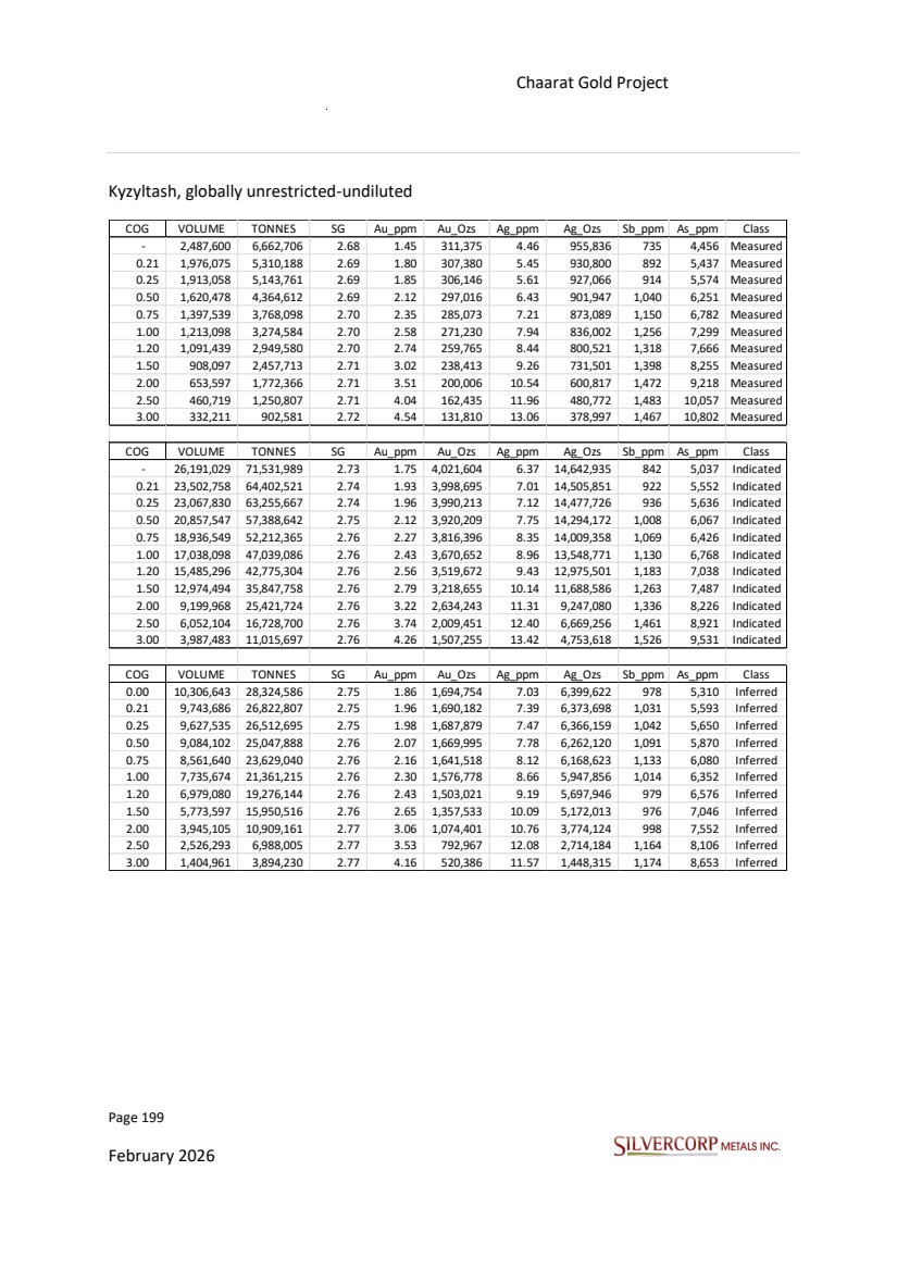
| Page 200 February 2026 Chaarat Gold Project Chatkal district, Kyrgyzstan NI 43-101 Technical Report Mineral Resource Update APPENDIX 4 DRILL HOLE INFORMATION |
| Page 201 February 2026 Chaarat Gold Project Chatkal district, Kyrgyzstan NI 43-101 Technical Report Mineral Resource Update HOLE_ID PROJECT EASTING NORTHING ELEVATION (m) DEPTH (m) AZIMUTH (°) DIP (°) TYPEWORK YEAR LICENSE_NUMBER CCH0001 KYZYLTASH 12680362 4656684 2464 273 335 -14 DH 2000 3117AE CCH0003 KYZYLTASH 12681008 4656930 2294 277 310 -4 DH 2000 2626AP CCH0004 KYZYLTASH 12681202 4657352 2444 240 315 -25 DH 2000 3117AE CCH0005 KYZYLTASH 12681441 4657419 2404 301 308 -19 DH 2000 3117AE CCH0008 KYZYLTASH 12682036 4658210 2486 231 310 -56 DH 2000 3117AE CCH0010 KYZYLTASH 12681963 4657738 2382 254 310 -20 DH 2000 2626AP CCH0011 KYZYLTASH 12682388 4658210 2273 228 310 -50 DH 2000 2626AP CCH0412 KYZYLTASH 12681691 4657649 2431 221 293 -49 DH 2004 3117AE CCH0413 KYZYLTASH 12681729 4657638 2411 108 293 -49 DH 2004 3117AE CCH0414 KYZYLTASH 12680424 4656781 2492 201 335 -45 DH 2004 3117AE CCH0415 KYZYLTASH 12682265 4659430 2462 129 145 -49 DH 2004 3117AE CCH0416 KYZYLTASH 12681035 4657045 2342 198 320 -45 DH 2004 3117AE CCH0517 KYZYLTASH 12680422 4656785 2494 122 335 -15 DH 2005 3117AE CCH0518 KYZYLTASH 12680478 4656865 2497 95 335 -20 DH 2005 3117AE CCH0519 KYZYLTASH 12680354 4656692 2464 211 335 -35 DH 2005 3117AE CCH0520 KYZYLTASH 12680151 4656560 2447 137 300 -20 DH 2005 3117AE CCH0521 KYZYLTASH 12680154 4656567 2446 58 300 -20 DH 2005 3117AE CCH0522 KYZYLTASH 12680353 4656695 2465 259 300 -20 DH 2005 3117AE CCH0523 KYZYLTASH 12680964 4656900 2292 283 320 -15 DH 2005 2626AP CCH0524 KYZYLTASH 12680950 4656967 2335 242 310 -15 DH 2005 3117AE CCH0525 KYZYLTASH 12681002 4656925 2291 225 320 -25 DH 2005 2626AP CCH0526 KYZYLTASH 12681002 4657014 2337 155 312 -10 DH 2005 3117AE CCH0527 KYZYLTASH 12681059 4656956 2278 252 314 -20 DH 2005 2626AP CCH0528 KYZYLTASH 12681036 4657046 2342 154 320 -20 DH 2005 3117AE CCH0529 KYZYLTASH 12681100 4657040 2315 186 320 -20 DH 2005 2626AP CCH0530 KYZYLTASH 12681146 4657018 2285 284 311 -32 DH 2005 2626AP CCH0531 KYZYLTASH 12681154 4657067 2311 163 320 -25 DH 2005 2626AP CCH0532 KYZYLTASH 12681187 4657050 2289 153 320 -40 DH 2005 2626AP CCH0533 KYZYLTASH 12681822 4657752 2433 160 315 -40 DH 2005 3117AE CCH0534 KYZYLTASH 12681772 4657688 2434 180 315 -40 DH 2005 3117AE CCH0535 KYZYLTASH 12681719 4657677 2433 152 295 -30 DH 2005 3117AE CCH0536 KYZYLTASH 12681655 4657595 2424 202 310 -15 DH 2005 3117AE CCH0537 KYZYLTASH 12681597 4657519 2432 255 315 -10 DH 2005 3117AE CCH0538 KYZYLTASH 12681499 4657519 2439 250 315 -20 DH 2005 3117AE CCH0539 KYZYLTASH 12682230 4659322 2526 271 125 -71 DH 2005 3117AE CCH0540 KYZYLTASH 12682229 4659322 2526 314 305 -80 DH 2005 3117AE CCH0541 KYZYLTASH 12682173 4659167 2563 269 125 -81 DH 2005 3117AE CCH0542 KYZYLTASH 12682171 4659169 2563 244 305 -75 DH 2005 3117AE CCH0543 KYZYLTASH 12682138 4659004 2604 147 305 -85 DH 2005 3117AE CCH0544 KYZYLTASH 12682137 4659004 2604 290 305 -70 DH 2005 3117AE CCH0545 KYZYLTASH 12682047 4658875 2680 138 0 -90 DH 2005 3117AE CCH0546 KYZYLTASH 12682047 4658875 2680 271 305 -70 DH 2005 3117AE CCH0553 KYZYLTASH 12682178 4659071 2579 185 0 -90 DH 2005 3117AE CCH0555 KYZYLTASH 12682087 4658939 2643 125 125 -81 DH 2005 3117AE CCH0556 KYZYLTASH 12682086 4658938 2643 251 305 -73 DH 2005 3117AE CCH0666 KYZYLTASH 12679412 4656294 2452 52 110 -75 DH 2006 3117AE CCH0666bis KYZYLTASH 12679345 4656294 2459 190 110 -75 DH 2006 3117AE CCH0667bis2 KYZYLTASH 12679352 4656190 2420 98 110 -75 DH 2006 3117AE CCH0669 KYZYLTASH 12680760 4656904 2365 221 350 -35 DH 2006 3117AE CCH0670 KYZYLTASH 12680759 4656904 2365 245 320 -35 DH 2006 3117AE CCH0671 KYZYLTASH 12681236 4657385 2451 241 343 -21 DH 2006 3117AE CCH0672 KYZYLTASH 12681232 4657382 2450 219 290 -20 DH 2006 3117AE CCH0673 KYZYLTASH 12681425 4658068 2763 173 305 -20 DH 2006 3117AE CCH0674 KYZYLTASH 12681426 4658068 2762 291 305 -36 DH 2006 3117AE CCH0675bis KYZYLTASH 12681360 4658026 2721 225 320 -31 DH 2006 3117AE CCH0676 KYZYLTASH 12681360 4658026 2722 130 305 -9 DH 2006 3117AE CCH0677 KYZYLTASH 12681284 4657954 2728 138 305 -15 DH 2006 3117AE CCH0678 KYZYLTASH 12681284 4657954 2728 219 305 -35 DH 2006 3117AE CCH0679 KYZYLTASH 12681754 4658402 2714 160 305 -12 DH 2006 3117AE CCH0680 KYZYLTASH 12681827 4658489 2719 81 305 -12 DH 2006 3117AE CCH0681 KYZYLTASH 12681827 4658489 2719 322 305 -30 DH 2006 3117AE CCH0682 KYZYLTASH 12681859 4658557 2717 135 305 -16 DH 2006 3117AE CCH0683 KYZYLTASH 12681859 4658557 2717 324 305 -33 DH 2006 3117AE |
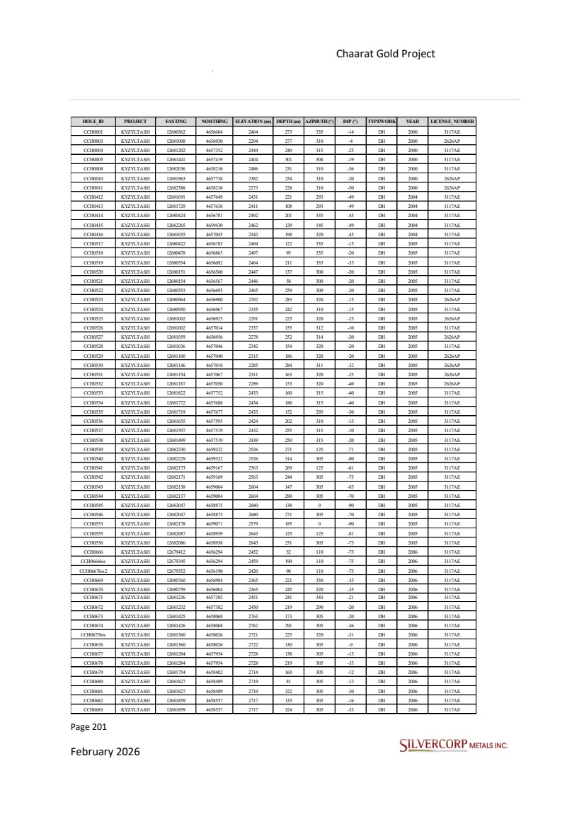
| Page 202 February 2026 Chaarat Gold Project Chatkal district, Kyrgyzstan NI 43-101 Technical Report Mineral Resource Update HOLE_ID PROJECT EASTING NORTHING ELEVATION (m) DEPTH (m) AZIMUTH (°) DIP (°) TYPEWORK YEAR LICENSE_NUMBER CCH0684 KYZYLTASH 12681966 4658655 2742 139 305 -7 DH 2006 3117AE CCH0685 KYZYLTASH 12681966 4658655 2740 211 305 -24 DH 2006 3117AE CCH0686 KYZYLTASH 12681966 4659010 2709 552 355 -80 DH 2006 3117AE CCH0688 KYZYLTASH 12680140 4656667 2473 212 130 -80 DH 2006 3117AE CCH07100 KYZYLTASH 12680349 4656694 2463 164 278 -20 DH 2007 3117AE CCH07101 KYZYLTASH 12680010 4656645 2523 185 82 -56 DH 2007 3117AE CCH07105 KYZYLTASH 12680499 4656845 2478 190 335 -43 DH 2007 3117AE CCH07106 KYZYLTASH 12682502 4658349 2257 205 315 -45 DH 2007 3117AE CCH07117 KYZYLTASH 12681963 4659015 2710 502 260 -76 DH 2007 3117AE CCH07118 KYZYLTASH 12682555 4659485 2543 139 160 -60 DH 2007 3117AE CCH07119 KYZYLTASH 12682681 4659601 2583 185 160 -60 DH 2007 3117AE CCH07120 KYZYLTASH 12682561 4659486 2544 182 340 -20 DH 2007 3117AE CCH07121 KYZYLTASH 12682678 4659603 2584 112 300 -20 DH 2007 3117AE CCH07122 KYZYLTASH 12682134 4659008 2605 109 125 -65 DH 2007 3117AE CCH07123 KYZYLTASH 12682135 4659003 2604 270 305 -76 DH 2007 3117AE CCH07124 KYZYLTASH 12680154 4656561 2446 186 310 -40 DH 2007 3117AE CCH07125bis KYZYLTASH 12680385 4656641 2429 258 284 -21 DH 2007 3117AE CCH07127 KYZYLTASH 12680010 4656648 2523 207 115 -48 DH 2007 3117AE CCH07128 KYZYLTASH 12680840 4657126 2441 217 181 -57 DH 2007 3117AE CCH07130 KYZYLTASH 12682709 4659867 2579 121 0 -90 DH 2007 3117AE CCH07131 KYZYLTASH 12682710 4659867 2577 82 145 -50 DH 2007 3117AE CCH07132 KYZYLTASH 12682710 4659865 2578 99 185 -34 DH 2007 3117AE CCH07133 KYZYLTASH 12682710 4659870 2577 130 80 -50 DH 2007 3117AE CCH07134 KYZYLTASH 12682134 4659009 2605 167 34 -59 DH 2007 3117AE CCH07135 KYZYLTASH 12682133 4659006 2605 301 335 -68 DH 2007 3117AE CCH07136 KYZYLTASH 12682133 4659004 2605 176 305 -45 DH 2007 3117AE CCH07137 KYZYLTASH 12682086 4658936 2644 198 305 -80 DH 2007 3117AE CCH07138 KYZYLTASH 12682087 4658938 2644 133 45 -66 DH 2007 3117AE CCH07139 KYZYLTASH 12682086 4658936 2644 312 336 -70 DH 2007 3117AE CCH07140 KYZYLTASH 12682044 4658873 2679 213 305 -75 DH 2007 3117AE CCH07141 KYZYLTASH 12682047 4658872 2679 113 125 -60 DH 2007 3117AE CCH07143 KYZYLTASH 12682044 4658871 2679 330 277 -67 DH 2007 3117AE CCH07151 KYZYLTASH 12682085 4657803 2340 183 340 -45 DH 2007 2626AP CCH07152 KYZYLTASH 12681303 4658187 2827 187 125 -83 DH 2007 3117AE CCH07153 KYZYLTASH 12681301 4658186 2826 318 300 -80 DH 2007 3117AE CCH07154 KYZYLTASH 12681274 4658176 2826 180 85 -51 DH 2007 3117AE CCH07155 KYZYLTASH 12681146 4658008 2840 242 118 -80 DH 2007 3117AE CCH07157 KYZYLTASH 12681645 4658523 2820 212 38 -90 DH 2007 3117AE CCH07158 KYZYLTASH 12681677 4658588 2828 266 84 -63 DH 2007 3117AE CCH07159bis KYZYLTASH 12681676 4658586 2828 178 43 -72 DH 2007 3117AE CCH07161 KYZYLTASH 12681668 4658579 2827 261 162 -90 DH 2007 3117AE CCH07164 KYZYLTASH 12682353 4659524 2520 69 160 -55 DH 2007 3117AE CCH0798 KYZYLTASH 12680349 4656696 2463 205 300 -50 DH 2007 3117AE CCH0799 KYZYLTASH 12680349 4656694 2464 234 278 -40 DH 2007 3117AE CCH08C401 KYZYLTASH 12680974 4657934 2864 263 125 -66 DH 2008 3117AE CCH08C402 KYZYLTASH 12681291 4658184 2825 406 300 -74 DH 2008 3117AE CCH08C403 KYZYLTASH 12681434 4658199 2829 93 45 -53 DH 2008 3117AE CCH08C407BIS KYZYLTASH 12681426 4658066 2761 122 305 -70 DH 2008 3117AE CCH08C461 KYZYLTASH 12681678 4658587 2827 282 45 -72 DH 2008 3117AE CCH08C464 KYZYLTASH 12681644 4658523 2820 358 315 -75 DH 2008 3117AE CCH08C465 KYZYLTASH 12681647 4658524 2820 194 135 -61 DH 2008 3117AE CCH08C531 KYZYLTASH 12682032 4658874 2687 111 215 -42 DH 2008 3117AE CCH08C532 KYZYLTASH 12682029 4658876 2687 189 35 -67 DH 2008 3117AE CCH08C535 KYZYLTASH 12682173 4659072 2579 307 305 -70 DH 2008 3117AE CCH08C536 KYZYLTASH 12682131 4659004 2606 289 335 -72 DH 2008 3117AE CCH08C537 KYZYLTASH 12682135 4658999 2604 233 270 -67 DH 2008 3117AE CCH08M24-1 KYZYLTASH 12680018 4656609 2525 195 135 -75 DH 2008 3117AE CCH08M243 KYZYLTASH 12680498 4656846 2478 294 335 -65 DH 2008 3117AE CCH08M244 KYZYLTASH 12680435 4656752 2470 342 335 -45 DH 2008 3117AE CCH08M245 KYZYLTASH 12680435 4656752 2469 296 335 -55 DH 2008 3117AE CCH08M24-5 KYZYLTASH 12680325 4656881 2580 210 155 -70 DH 2008 3117AE CCH08M3012BIS KYZYLTASH 12681037 4656998 2311 287 315 -48 DH 2008 2626AP CCH08M3013 KYZYLTASH 12681161 4657304 2450 109 280 -45 DH 2008 3117AE |
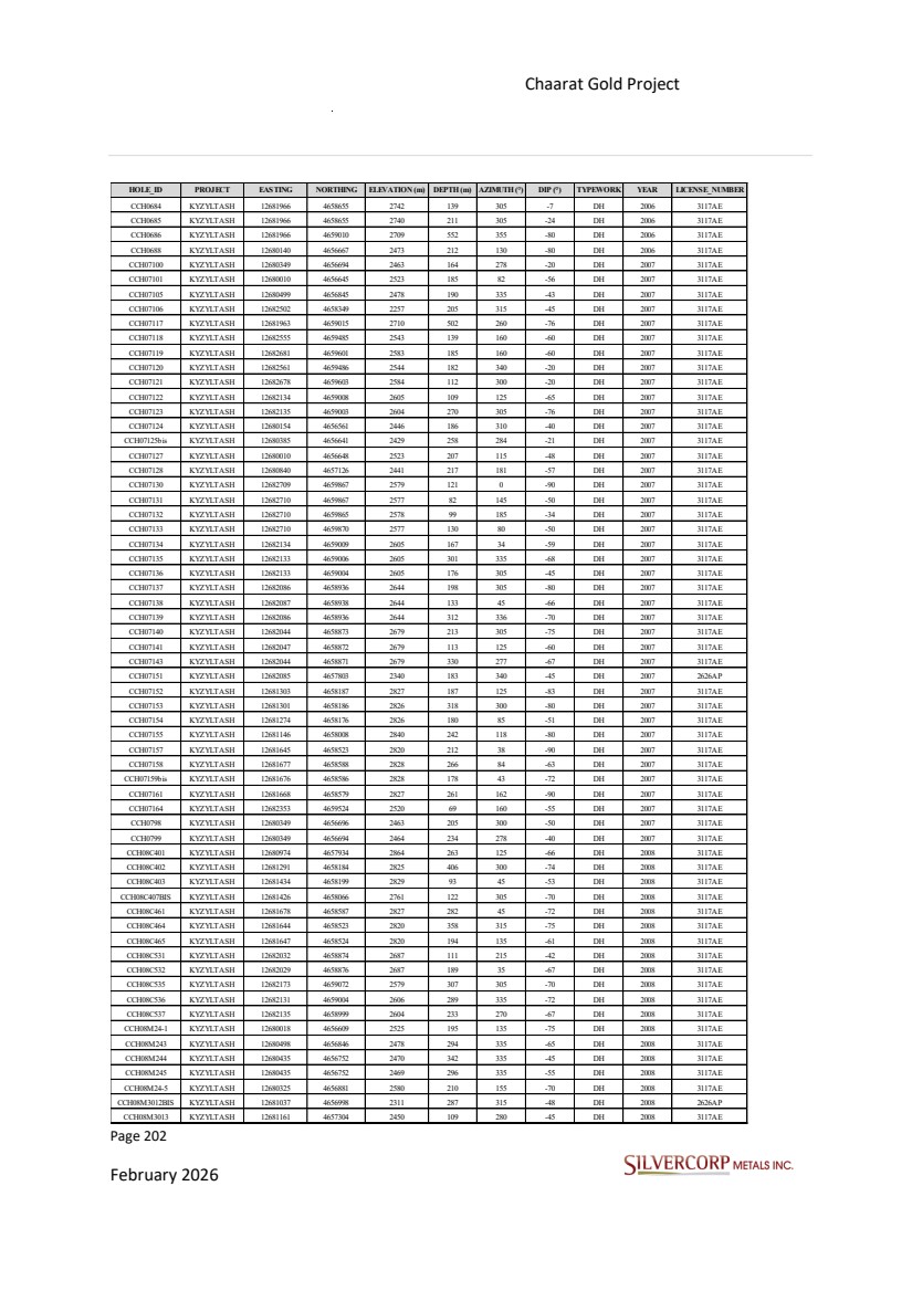
| Page 203 February 2026 Chaarat Gold Project Chatkal district, Kyrgyzstan NI 43-101 Technical Report Mineral Resource Update HOLE_ID PROJECT EASTING NORTHING ELEVATION (m) DEPTH (m) AZIMUTH (°) DIP (°) TYPEWORK YEAR LICENSE_NUMBER CCH08M3014 KYZYLTASH 12681193 4657310 2432 110 340 -45 DH 2008 3117AE CCH08M3015 KYZYLTASH 12681225 4657298 2412 233 320 -45 DH 2008 3117AE CCH08M3016 KYZYLTASH 12681270 4657349 2425 162 320 -45 DH 2008 3117AE CCH08M3018 KYZYLTASH 12681114 4657129 2364 194 315 -35 DH 2008 3117AE CCH08M302 KYZYLTASH 12680947 4656964 2333 291 310 -35 DH 2008 3117AE CCH08M304 KYZYLTASH 12681103 4657039 2315 315 320 -32 DH 2008 2626AP CCH08M309bis2 KYZYLTASH 12680951 4657158 2451 220 135 -55 DH 2008 3117AE CCH08M3416 KYZYLTASH 12681270 4657349 2425 230 320 -60 DH 2008 3117AE CCH08M392 KYZYLTASH 12681729 4657636 2410 301 295 -60 DH 2008 3117AE CCH08M394 KYZYLTASH 12681598 4657521 2431 341 315 -45 DH 2008 3117AE CCH08M395bis KYZYLTASH 12681480 4657516 2438 298 315 -53 DH 2008 3117AE CCH08M397 KYZYLTASH 12681475 4657513 2439 271 289 -32 DH 2008 3117AE CCH08M398Bis KYZYLTASH 12681658 4657655 2441 67 310 -45 DH 2008 3117AE CCH08M399 KYZYLTASH 12681769 4657689 2435 241 315 -60 DH 2008 3117AE CCH08M443 KYZYLTASH 12682084 4657796 2340 185 297 -46 DH 2008 2626AP CCH08M501bis KYZYLTASH 12682508 4658354 2257 254 342 -45 DH 2008 3117AE CCH08M502 KYZYLTASH 12682504 4658351 2257 201 283 -45 DH 2008 3117AE CCH08M601 KYZYLTASH 12682652 4659708 2616 73 170 -60 DH 2008 3117AE CCH08M602 KYZYLTASH 12682652 4659711 2617 133 350 -84 DH 2008 3117AE CCH08M603 KYZYLTASH 12682547 4659577 2606 137 123 -65 DH 2008 3117AE CCH08M604 KYZYLTASH 12682546 4659577 2606 95 0 -90 DH 2008 3117AE UG_ADh_170 KYZYLTASH 12682069 4659059 2322 110 304 -20 DH_undg 2008 3117AE UG_ADh_171 KYZYLTASH 12682069 4659059 2322 131 323 -20 DH_undg 2008 3117AE UG_ADh_172 KYZYLTASH 12682068 4659057 2322 135 280 -21 DH_undg 2008 3117AE UG_ADh_173 KYZYLTASH 12682069 4659059 2322 199 322 -29 DH_undg 2008 3117AE UG_ADh_174 KYZYLTASH 12682068 4659058 2322 117 290 -29 DH_undg 2008 3117AE UG_ADh_175 KYZYLTASH 12682069 4659059 2322 124 323 -33 DH_undg 2008 3117AE UG_ADh_176 KYZYLTASH 12682068 4659057 2322 110 275 -17 DH_undg 2008 3117AE UG_ADh_177 KYZYLTASH 12682068 4659057 2322 151 281 -27 DH_undg 2008 3117AE UG_ADh_178 KYZYLTASH 12682069 4659059 2322 158 319 -27 DH_undg 2008 3117AE UG_ADh_179 KYZYLTASH 12681920 4659145 2322 151 58 -35 DH_undg 2008 3117AE UG_ADh_179bis KYZYLTASH 12681920 4659145 2322 286 50 -35 DH_undg 2008 3117AE UG_ADh_180 KYZYLTASH 12681919 4659145 2321 190 24 -57 DH_undg 2008 3117AE UG_ADh_180bis KYZYLTASH 12681919 4659145 2321 404 28 -57 DH_undg 2008 3117AE UG_ADh_181 KYZYLTASH 12681919 4659145 2321 273 4 -63 DH_undg 2008 3117AE UG_ADh_181bis KYZYLTASH 12681919 4659145 2321 357 6 -56 DH_undg 2008 3117AE UG_ADh_182 KYZYLTASH 12681918 4659145 2321 418 341 -62 DH_undg 2008 3117AE UG_ADh_183 KYZYLTASH 12681916 4659144 2321 245 303 -76 DH_undg 2008 3117AE UG_ADh_183bis KYZYLTASH 12681916 4659144 2321 334 305 -75 DH_undg 2008 3117AE UG_ADh_184 KYZYLTASH 12681916 4659144 2321 398 305 -70 DH_undg 2008 3117AE UG_ADh_185 KYZYLTASH 12681916 4659141 2321 226 125 -86 DH_undg 2008 3117AE UG_ADh_186 KYZYLTASH 12681919 4659142 2321 270 190 -52 DH_undg 2008 3117AE UG_ADh_187 KYZYLTASH 12681916 4659140 2321 304 228 -59 DH_undg 2008 3117AE UG_ADh_188 KYZYLTASH 12681915 4659142 2321 285 258 -63 DH_undg 2008 3117AE UG_ADh_190 KYZYLTASH 12681920 4659144 2321 250 70 -70 DH_undg 2008 3117AE UG_ADh_191 KYZYLTASH 12681919 4659145 2321 285 13 -76 DH_undg 2008 3117AE UG_ADh_192 KYZYLTASH 12681918 4659145 2321 403 348 -72 DH_undg 2008 3117AE UG_Adh_193 KYZYLTASH 12681757 4659039 2320 180 99 -37 DH_undg 2008 3117AE UG_Adh_195 KYZYLTASH 12681756 4659037 2320 146 133 -41 DH_undg 2008 3117AE UG_Adh_196 KYZYLTASH 12681755 4659038 2320 181 130 -75 DH_undg 2008 3117AE CCH09C4691 KYZYLTASH 12681835 4658483 2720 376 315 -45 DH 2009 3117AE CCH09M2491 KYZYLTASH 12680011 4656648 2522 270 144 -80 DH 2009 3117AE CCH09M2492 KYZYLTASH 12679945 4656578 2579 204 137 -64 DH 2009 3117AE CCH09M2493 KYZYLTASH 12679945 4656576 2579 283 139 -77 DH 2009 3117AE CCH09M3094 KYZYLTASH 12681154 4657069 2311 309 315 -49 DH 2009 2626AP CCH09M3095 KYZYLTASH 12681184 4657163 2360 235 315 -45 DH 2009 3117AE CCH09M3096 KYZYLTASH 12681181 4657163 2360 259 315 -58 DH 2009 3117AE CCH09M6093bis KYZYLTASH 12682673 4659882 2607 250 0 -90 DH 2009 3117AE CCH09UG001 KYZYLTASH 12681756 4659037 2323 217 140 18 dh_undg 2009 3117AE CCH09UG004BIS KYZYLTASH 12681751 4659039 2320 240 275 -86 DH_undg 2009 3117AE CCH09UG005 KYZYLTASH 12681754 4659035 2322 217 158 16 DH_undg 2009 3117AE CCH09UG006 KYZYLTASH 12681754 4659035 2321 181 165 -2 DH_undg 2009 3117AE CCH09UG007 KYZYLTASH 12681754 4659035 2321 164 176 -32 DH_undg 2009 3117AE |
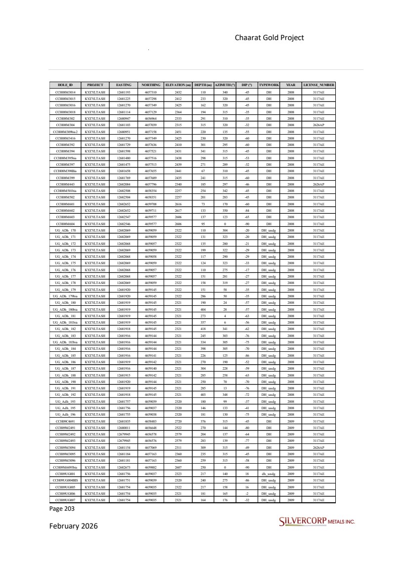
| Page 204 February 2026 Chaarat Gold Project Chatkal district, Kyrgyzstan NI 43-101 Technical Report Mineral Resource Update HOLE_ID PROJECT EASTING NORTHING ELEVATION (m) DEPTH (m) AZIMUTH (°) DIP (°) TYPEWORK YEAR LICENSE_NUMBER CCH09UG008 KYZYLTASH 12681753 4659037 2320 198 192 -56 dh_undg 2009 3117AE CCH09UG009 KYZYLTASH 12681752 4659037 2320 274 215 -70 dh_undg 2009 3117AE CCH09UG010 KYZYLTASH 12681751 4659039 2320 333 243 -73 dh_undg 2009 3117AE CCH09UG011 KYZYLTASH 12681756 4659037 2323 234 117 19 dh_undg 2009 3117AE CCH09UG8001 KYZYLTASH 12682069 4659058 2325 54 301 47 dh_undg 2009 3117AE CCH09UG808 KYZYLTASH 12682070 4659054 2326 142 224 53 dh_undg 2009 3117AE CCH09UG808A KYZYLTASH 12682069 4659055 2325 115 247 34 dh_undg 2009 3117AE GDM301 KYZYLTASH 12681115 4657132 2364 250 312 -55 DHGD 2009 3117AE CCH09UG012 KYZYLTASH 12681587 4658849 2326 223 143 21 dh_undg 2010 3117AE CCH09UG014 KYZYLTASH 12681588 4658849 2325 323 133 8 dh_undg 2010 3117AE CCH09UG015 KYZYLTASH 12681590 4658851 2325 185 109 10 dh_undg 2010 3117AE CCH10C4601 KYZYLTASH 12681864 4658560 2721 368 315 -41 DH 2010 3117AE CCH10C4602 KYZYLTASH 12681971 4658657 2741 235 310 -40 DH 2010 3117AE CCH10C4603 KYZYLTASH 12681635 4658472 2816 156 307 -66 DH 2010 3117AE CCH10M2401 KYZYLTASH 12679944 4656580 2581 211 135 -75 DH 2010 3117AE CCH10M2402 KYZYLTASH 12679944 4656579 2579 296 186 -71 DH 2010 3117AE CCH10M2405bis KYZYLTASH 12680417 4656912 2554 180 135 -80 DH 2010 3117AE CCH10M2406 KYZYLTASH 12680484 4656955 2543 151 135 -63 DH 2010 3117AE CCH10M2407 KYZYLTASH 12680053 4656591 2505 223 0 -90 DH 2010 3117AE CCH10M2408 KYZYLTASH 12680120 4656607 2464 175 0 -90 DH 2010 3117AE CCH10M3001 KYZYLTASH 12680929 4656962 2333 314 315 -45 DH 2010 3117AE CCH10M3002 KYZYLTASH 12681031 4656935 2278 346 315 -47 DH 2010 2626AP CCH10M3003 KYZYLTASH 12681102 4657039 2315 315 314 -55 DH 2010 2626AP CCH10M3903 KYZYLTASH 12681821 4657654 2387 308 315 -43 DH 2010 2626AP CCH10UG016 KYZYLTASH 12681585 4658854 2325 43 0 0 dh_undg 2010 3117AE CCH10UG017 KYZYLTASH 12681752 4659041 2322 55 0 0 dh_undg 2010 3117AE CCH10UG18 KYZYLTASH 12681588 4658849 2324 115 135 -23 dh_undg 2010 3117AE CCH10UG19 KYZYLTASH 12681590 4658851 2324 136 97 -17 dh_undg 2010 3117AE CCH10UG20 KYZYLTASH 12681587 4658848 2324 150 169 -15 dh_undg 2010 3117AE CCH10UG21 KYZYLTASH 12681586 4658848 2324 177 194 -58 dh_undg 2010 3117AE CCH10UG22 KYZYLTASH 12681588 4658849 2323 121 135 -76 dh_undg 2010 3117AE CCH10UG401 KYZYLTASH 12682056 4659274 2323 165 132 0 dh_undg 2010 3117AE CCH10UG402 KYZYLTASH 12682056 4659276 2323 195 102 0 dh_undg 2010 3117AE CCH10UG403 KYZYLTASH 12682056 4659275 2323 172 115 0 dh_undg 2010 3117AE CCH10UG404 KYZYLTASH 12682056 4659274 2322 120 130 -41 dh_undg 2010 3117AE CCH10UG405 KYZYLTASH 12682056 4659275 2322 141 107 -38 dh_undg 2010 3117AE CCH10UG23 KYZYLTASH 12681589 4658852 2323 152 63 -55 dh_undg 2011 3117AE CCH10UG24 KYZYLTASH 12681586 4658850 2324 256 235 -72 dh_undg 2011 3117AE CCH10UG25 KYZYLTASH 12681586 4658851 2323 186 315 -80 dh_undg 2011 3117AE CCH10UG26 KYZYLTASH 12681587 4658853 2324 214 26 -67 dh_undg 2011 3117AE CCH10UG406 KYZYLTASH 12682054 4659275 2322 174 120 -79 dh_undg 2011 3117AE CCH10UG407 KYZYLTASH 12682053 4659273 2322 149 173 -34 dh_undg 2011 3117AE CCH10UG408 KYZYLTASH 12682053 4659274 2322 179 193 -62 dh_undg 2011 3117AE CCH10UG409 KYZYLTASH 12682052 4659276 2322 303 333 -84 dh_undg 2011 3117AE CCH10UG410 KYZYLTASH 12682052 4659276 2322 412 321 -78 dh_undg 2011 3117AE CCH10UG601 KYZYLTASH 12681694 4659096 2321 300 158 -85 dh_undg 2011 3117AE CCH11C46102 KYZYLTASH 12681953 4658598 2713 355 325 -40 DH 2011 3117AE CCH11C46104 KYZYLTASH 12682005 4658615 2712 226 325 -40 DH 2011 3117AE CCH11M24101 KYZYLTASH 12680328 4656879 2583 342 135 -80 DH 2011 3117AE CCH11M24102 KYZYLTASH 12680242 4656853 2565 257 135 -65 DH 2011 3117AE CCH11M24103 KYZYLTASH 12679992 4656439 2506 250 315 -72 DH 2011 3117AE CCH11M24104 KYZYLTASH 12679891 4656416 2492 273 0 -90 DH 2011 3117AE CCH11M24105 KYZYLTASH 12679620 4656245 2456 170 315 -30 DH 2011 3117AE CCH11M24106 KYZYLTASH 12679624 4656237 2456 153 135 -60 DH 2011 3117AE CCH11M24107 KYZYLTASH 12679684 4656282 2461 125 315 -30 DH 2011 3117AE CCH11M30101 KYZYLTASH 12681030 4656865 2252 434 315 -45 DH 2011 2626AP CCH11M30102 KYZYLTASH 12681056 4656961 2280 329 315 -45 DH 2011 2626AP CCH11M30103 KYZYLTASH 12681113 4656998 2283 350 315 -49 DH 2011 2626AP CCH11M30104 KYZYLTASH 12681181 4657051 2289 366 315 -51 DH 2011 2626AP CCH11M30105 KYZYLTASH 12681232 4657114 2309 352 315 -47 DH 2011 2626AP |
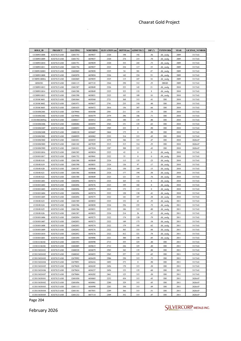
| Page 205 February 2026 Chaarat Gold Project Chatkal district, Kyrgyzstan NI 43-101 Technical Report Mineral Resource Update HOLE_ID PROJECT EASTING NORTHING ELEVATION (m) DEPTH (m) AZIMUTH (°) DIP (°) TYPEWORK YEAR LICENSE_NUMBER CCH11M30106bis KYZYLTASH 12680862 4656911 2326 312 315 -45 DH 2011 3117AE CCH11UG27 KYZYLTASH 12681586 4658850 2323 345 269 -71 dh_undg 2011 3117AE CCH11UG28 KYZYLTASH 12681586 4658851 2323 275 315 -71 dh_undg 2011 3117AE CCH11UG29 KYZYLTASH 12681586 4658853 2324 287 2 -67 dh_undg 2011 3117AE CCH11UG30 KYZYLTASH 12681588 4658849 2327 289 135 36 dh_undg 2011 3117AE CCH11UG31 KYZYLTASH 12681589 4658849 2326 252 113 26 dh_undg 2011 3117AE CCH11UG411 KYZYLTASH 12682053 4659276 2322 313 225 -74 dh_undg 2011 3117AE CCH11UG412 KYZYLTASH 12682053 4659276 2322 343 259 -75 dh_undg 2011 3117AE CCH11UG414 KYZYLTASH 12682056 4659278 2322 155 88 -34 dh_undg 2011 3117AE CCH11UG415 KYZYLTASH 12682055 4659278 2322 206 65 -59 dh_undg 2011 3117AE CCH11UG416 KYZYLTASH 12682054 4659278 2322 262 38 -68 dh_undg 2011 3117AE CCH11UG417 KYZYLTASH 12682053 4659275 2322 429 275 -74 dh_undg 2011 3117AE CCH11UG418bis KYZYLTASH 12682052 4659277 2322 505 322 -73 dh_undg 2011 3117AE CCH11UG419 KYZYLTASH 12682052 4659277 2322 530 320 -70 dh_undg 2011 3117AE CCH11UG602 KYZYLTASH 12681691 4659098 2321 394 300 -84 dh_undg 2011 3117AE CCH11UG603 KYZYLTASH 12681691 4659099 2321 514 309 -77 dh_undg 2011 3117AE CCH11UG604 KYZYLTASH 12681692 4659100 2321 530 311 -71 dh_undg 2011 3117AE CCH11UG605 KYZYLTASH 12681695 4659099 2321 421 50 -78 dh_undg 2011 3117AE CCH11UG606 KYZYLTASH 12681694 4659099 2321 443 10 -79 dh_undg 2011 3117AE CCH11WC5301bis KYZYLTASH 12682767 4658693 2278 235 315 -25 DH 2011 2626AP CCH12C53002 KYZYLTASH 12681995 4658789 2726 53 135 -21 d h 2012 3117AE CCH12C53003 KYZYLTASH 12682188 4659150 2570 110 135 -54 d h 2012 3117AE CCH12C53004 KYZYLTASH 12682130 4658988 2607 67 135 -35 d h 2012 3117AE CCH12C53005 KYZYLTASH 12682178 4659050 2573 65 135 -55 d h 2012 3117AE CCH12M24108 KYZYLTASH 12679688 4656279 2460 115 135 -75 d h 2012 3117AE CCH12M24109 KYZYLTASH 12679689 4656278 2460 80 135 -50 d h 2012 3117AE CCH12M24110 KYZYLTASH 12679993 4656437 2505 115 135 -60 d h 2012 3117AE CCH12M24111 KYZYLTASH 12679892 4656414 2491 140 135 -50 d h 2012 3117AE CCH12M24112 KYZYLTASH 12679836 4656409 2488 150 135 -45 d h 2012 3117AE CCH12M24113 KYZYLTASH 12679770 4656312 2474 151 135 -70 d h 2012 3117AE CCH12M24114 KYZYLTASH 12679890 4656415 2491 126 315 -75 d h 2012 3117AE CCH12M24115 KYZYLTASH 12679835 4656410 2488 129 135 -80 d h 2012 3117AE CCH12M24116 KYZYLTASH 12679771 4656311 2474 112 135 -50 d h 2012 3117AE CCH12M24117 KYZYLTASH 12679995 4656440 2506 62 135 -55 d h 2012 3117AE CCH12M24118 KYZYLTASH 12680526 4656908 2498 47 120 -60 d h 2012 3117AE CCH12M24119 KYZYLTASH 12680057 4656591 2505 122 135 -31 d h 2012 3117AE CCH12M24121 KYZYLTASH 12680051 4656522 2520 110 135 -45 d h 2012 3117AE CCH12M24122 KYZYLTASH 12680153 4656600 2447 105 315 -10 d h 2012 3117AE CCH12M30107 KYZYLTASH 12681078 4657253 2455 102 121 -64 d h 2012 3117AE CCH12M30108 KYZYLTASH 12681025 4657199 2455 130 135 -50 d h 2012 3117AE CCH12M30109 KYZYLTASH 12680876 4657128 2445 113 135 -36 d h 2012 3117AE CCH12M44001BIS KYZYLTASH 12682137 4657915 2339 144 135 -70 d h 2012 2626AP CCH12M44002 KYZYLTASH 12681997 4657930 2405 180 135 -45 d h 2012 3117AE CCH12M44003 KYZYLTASH 12682138 4657915 2339 82 135 -55 d h 2012 2626AP CCH12M44004 KYZYLTASH 12682049 4657768 2347 135 315 15 d h 2012 2626AP CCH13C53006 KYZYLTASH 12681998 4658784 2726 86 133 -34 d h 2013 3117AE CCH13C53008 KYZYLTASH 12682147 4658935 2608 31 172 -45 d h 2013 3117AE CCH13C53009 KYZYLTASH 12682078 4658849 2657 52 160 -45 d h 2013 3117AE CCH13C53010 KYZYLTASH 12682147 4658937 2608 42 172 -70 d h 2013 3117AE CCH13C53011 KYZYLTASH 12682078 4658849 2657 40 160 -70 d h 2013 3117AE CCH13C53012 KYZYLTASH 12682183 4659222 2544 206 135 -50 d h 2013 3117AE CCH13C53013 KYZYLTASH 12682218 4659283 2534 192 135 -50 d h 2013 3117AE CCH13C53014 KYZYLTASH 12682200 4659251 2540 197 135 -50 d h 2013 3117AE CCH13C53015 KYZYLTASH 12682181 4659223 2544 257 0 -90 d h 2013 3117AE CCH13C53016 KYZYLTASH 12681635 4658474 2816 150 0 -90 d h 2013 3117AE |
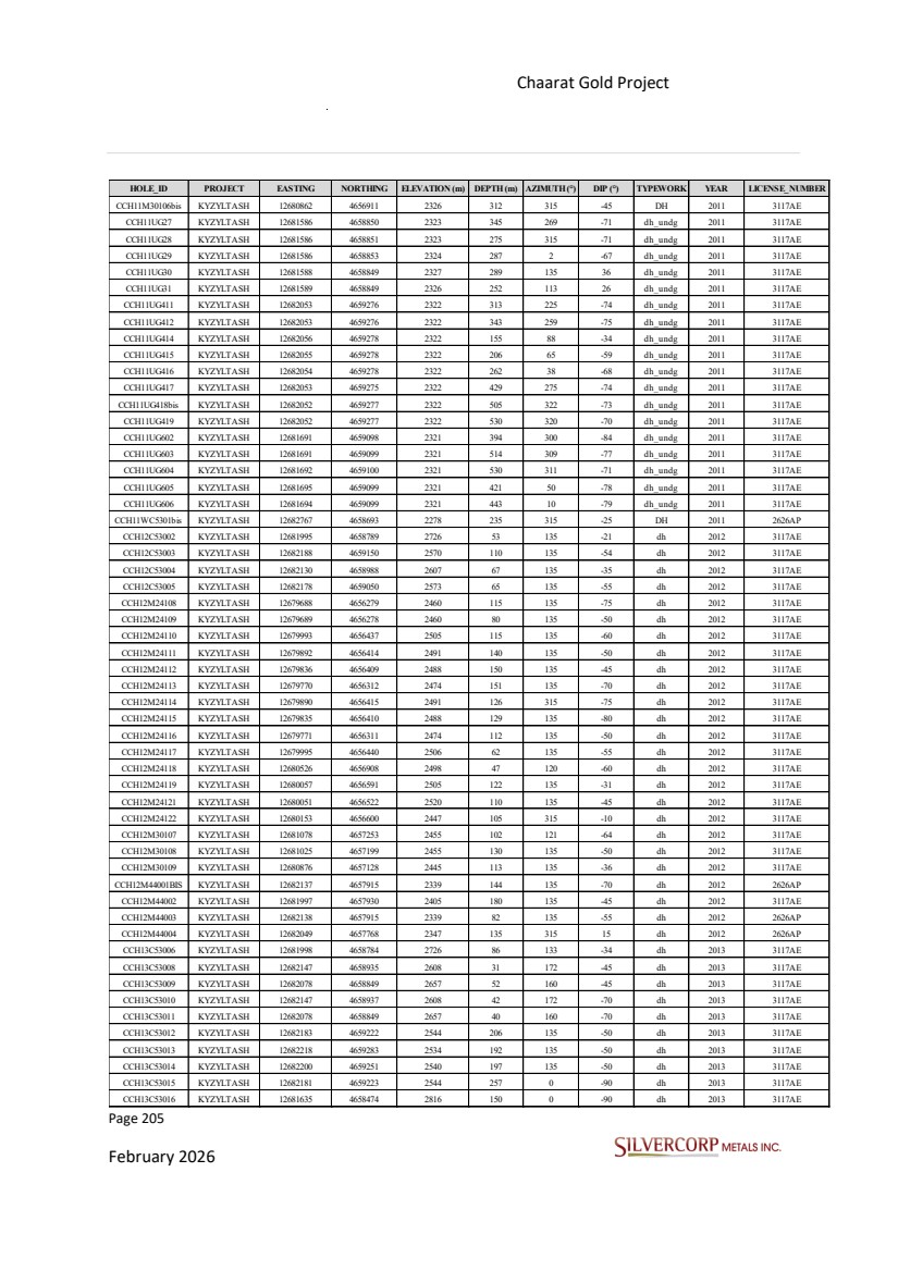
| Page 206 February 2026 Chaarat Gold Project Chatkal district, Kyrgyzstan NI 43-101 Technical Report Mineral Resource Update HOLE_ID PROJECT EASTING NORTHING ELEVATION (m) DEPTH (m) AZIMUTH (°) DIP (°) TYPEWORK YEAR LICENSE_NUMBER CCH13C53017 KYZYLTASH 12681700 4658624 2832 280 0 -90 d h 2013 3117AE CCH13C53018 KYZYLTASH 12681760 4658674 2833 205 135 -60 d h 2013 3117AE CCH13C53019 KYZYLTASH 12682176 4659084 2582 150 150 -60 d h 2013 3117AE CCH13C53020bis KYZYLTASH 12681821 4658897 2824 300 135 -45 d h 2013 3117AE CCH13C53021 KYZYLTASH 12681965 4659017 2709 249 135 -60 d h 2013 3117AE CCH13C53022 KYZYLTASH 12681820 4658733 2833 202 135 -60 d h 2013 3117AE CCH13C53023 KYZYLTASH 12681876 4658876 2802 237 135 -45 d h 2013 3117AE CCH13C53024 KYZYLTASH 12681754 4658638 2835 207 135 -50 d h 2013 3117AE CCH13C53025 KYZYLTASH 12681652 4658558 2825 278 135 -77 d h 2013 3117AE CCH13C53026 KYZYLTASH 12681854 4658808 2835 249 135 -45 d h 2013 3117AE CCH13C53027 KYZYLTASH 12681786 4658708 2833 195 135 -55 d h 2013 3117AE CCH13M24123 KYZYLTASH 12679832 4656412 2488 112 0 -90 d h 2013 3117AE CCH13M24124 KYZYLTASH 12679969 4656398 2499 171 0 -90 d h 2013 3117AE CCH13M24125 KYZYLTASH 12679766 4656315 2475 40 315 -43 d h 2013 3117AE CCH13M24126 KYZYLTASH 12679789 4656347 2479 20 315 -35 d h 2013 3117AE CCH13M24127 KYZYLTASH 12679855 4656618 2628 331 135 -45 d h 2013 3117AE CCH13M24128 KYZYLTASH 12679993 4656443 2506 145 0 -90 d h 2013 3117AE CCH13M24129 KYZYLTASH 12680029 4656569 2524 179 135 -60 d h 2013 3117AE CCH13M24130 KYZYLTASH 12680120 4656607 2464 140 160 -70 d h 2013 3117AE CCH13M24131 KYZYLTASH 12679942 4656587 2580 250 135 -50 d h 2013 3117AE CCH13M24132 KYZYLTASH 12680133 4656624 2461 76 0 -90 d h 2013 3117AE CCH13M24134 KYZYLTASH 12679963 4656403 2500 116 315 -35 d h 2013 3117AE CCH13M24135 KYZYLTASH 12680441 4656941 2549 109 0 -90 d h 2013 3117AE CCH13M24136 KYZYLTASH 12680472 4656914 2517 55 315 -37 d h 2013 3117AE CCH13M24137bis KYZYLTASH 12680384 4656880 2563 80 135 -83 d h 2013 3117AE CCH13M24138 KYZYLTASH 12680545 4656898 2486 36 260 -45 d h 2013 3117AE CCH13M24139 KYZYLTASH 12679812 4656376 2484 67 135 -80 d h 2013 3117AE CCH13M24140 KYZYLTASH 12680070 4656680 2501 119 0 -90 d h 2013 3117AE CCH13M24141 KYZYLTASH 12680449 4656817 2496 91 315 -40 d h 2013 3117AE CCH13M24142 KYZYLTASH 12680573 4656924 2489 40 315 -89 d h 2013 3117AE CCH13M24143 KYZYLTASH 12680527 4656909 2495 48 135 -82 d h 2013 3117AE CCH13M24144 KYZYLTASH 12680414 4656915 2554 102 0 -90 d h 2013 3117AE CCH13M24145 KYZYLTASH 12680475 4656912 2517 70 135 -70 d h 2013 3117AE CCH13M24146 KYZYLTASH 12680469 4656862 2502 80 315 -81 d h 2013 3117AE CCH13M24147 KYZYLTASH 12680469 4656859 2502 45 135 -77 d h 2013 3117AE CCH13M24148bis KYZYLTASH 12680418 4656917 2554 72 135 -70 d h 2013 3117AE CCH13M24149 KYZYLTASH 12680466 4656863 2502 73 315 -24 d h 2013 3117AE CCH13M24150 KYZYLTASH 12680528 4656912 2496 50 315 -25 d h 2013 3117AE CCH13M24151bis KYZYLTASH 12680357 4656858 2569 135 135 -65 d h 2013 3117AE CCH13M24152 KYZYLTASH 12680318 4656840 2556 201 135 -60 d h 2013 3117AE CCH13M24153 KYZYLTASH 12680536 4656961 2522 63 315 -27 d h 2013 3117AE CCH13M30111 KYZYLTASH 12680842 4657127 2441 142 180 -57 d h 2013 3117AE CCH13M30112 KYZYLTASH 12680863 4657089 2416 63 135 -68 d h 2013 3117AE CCH13M30113 KYZYLTASH 12680927 4657026 2377 99 135 -60 d h 2013 3117AE CCH13M30115 KYZYLTASH 12680996 4657009 2337 201 315 -35 d h 2013 3117AE CCH13M30116 KYZYLTASH 12681117 4657130 2364 247 305 -57 d h 2013 3117AE CCH13M30117 KYZYLTASH 12680871 4657130 2445 125 135 -60 d h 2013 3117AE CCH13M30118 KYZYLTASH 12680825 4657032 2387 91 0 -90 d h 2013 3117AE CCH13M30119 KYZYLTASH 12680785 4656999 2380 93 0 -90 d h 2013 3117AE CCH13M30120bis KYZYLTASH 12681000 4657233 2481 206 135 -66 d h 2013 3117AE CCH13M30121 KYZYLTASH 12681052 4657015 2316 262 315 -40 d h 2013 2626AP CCH13M30122bis KYZYLTASH 12681115 4657054 2316 250 315 -40 d h 2013 2626AP CCH13M30123 KYZYLTASH 12681177 4657163 2361 127 315 -20 d h 2013 3117AE CCH13M30124 KYZYLTASH 12681006 4657192 2455 170 135 -75 d h 2013 3117AE CCH13M30125 KYZYLTASH 12681029 4657262 2486 183 135 -60 d h 2013 3117AE CCH13M30126 KYZYLTASH 12681147 4657151 2363 173 315 -35 d h 2013 3117AE CCH13M30127 KYZYLTASH 12680881 4657169 2473 206 135 -55 d h 2013 3117AE CCH13M34001 KYZYLTASH 12681652 4657765 2501 200 135 -50 d h 2013 3117AE CCH13M34002 KYZYLTASH 12681549 4657699 2505 198 135 -60 d h 2013 3117AE |
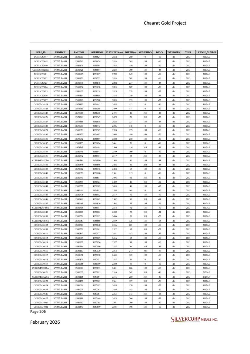
| Page 207 February 2026 Chaarat Gold Project Chatkal district, Kyrgyzstan NI 43-101 Technical Report Mineral Resource Update HOLE_ID PROJECT EASTING NORTHING ELEVATION (m) DEPTH (m) AZIMUTH (°) DIP (°) TYPEWORK YEAR LICENSE_NUMBER CCH13M34003 KYZYLTASH 12681130 4657438 2514 200 135 -60 d h 2013 3117AE CCH13M34004bis KYZYLTASH 12681227 4657570 2573 163 135 -50 d h 2013 3117AE CCH13M34005 KYZYLTASH 12681334 4657685 2581 211 135 -50 d h 2013 3117AE CCH13M34006 KYZYLTASH 12681256 4657647 2582 302 135 -45 d h 2013 3117AE CCH13M34007 KYZYLTASH 12681455 4657693 2565 231 135 -50 d h 2013 3117AE CCH0561 TULKUBASH 12678857 4655935 2517 151 230 -40 DH 2005 3117AE CCH0662bis TULKUBASH 12678903 4655902 2482 261 230 -40 DH 2006 3117AE CCH0663 TULKUBASH 12679096 4656083 2496 305 230 -30 DH 2006 3117AE CCH0664bis TULKUBASH 12678964 4656078 2524 282 230 -45 DH 2006 3117AE CCH0665 TULKUBASH 12678835 4656014 2554 174 230 -30 DH 2006 3117AE CCH0690 TULKUBASH 12678899 4655900 2483 109 180 -60 DH 2006 3117AE CCH07103 TULKUBASH 12678849 4655937 2517 204 135 -45 DH 2007 3117AE CCH07104 TULKUBASH 12678897 4655897 2483 303 225 -65 DH 2007 3117AE CCH07126 TULKUBASH 12678849 4655935 2519 198 225 -65 DH 2007 3117AE CCH07146 TULKUBASH 12678933 4655846 2451 269 225 -40 DH 2007 3117AE CCH07147 TULKUBASH 12678930 4655843 2449 155 180 -65 DH 2007 3117AE CCH07148 TULKUBASH 12678932 4655843 2451 163 135 -50 DH 2007 3117AE CCH0792 TULKUBASH 12678873 4655798 2452 236 230 -20 DH 2007 3117AE CCH0793bis TULKUBASH 12678879 4655799 2451 206 140 -65 DH 2007 3117AE CCH0794 TULKUBASH 12678954 4655899 2449 96 315 -20 DH 2007 3117AE CCH0795 TULKUBASH 12679029 4655981 2448 123 315 -20 DH 2007 3117AE CCH0796 TULKUBASH 12678792 4655850 2513 290 230 -45 DH 2007 3117AE CCH0797 TULKUBASH 12678792 4655855 2516 133 313 -20 DH 2007 3117AE CCH09T0791 TULKUBASH 12678739 4655861 2553 185 225 -50 DH 2009 3117AE CCH09T0792 TULKUBASH 12678946 4655794 2427 219 224 -50 DH 2009 3117AE CCH09T0793 TULKUBASH 12678912 4656082 2535 117 220 -50 DH 2009 3117AE CCH09T0793bis2 TULKUBASH 12678877 4655796 2451 73 140 -65 DH 2009 3117AE CCH09T0794 TULKUBASH 12679034 4656247 2583 209 218 -50 DH 2009 3117AE CCH10T0701 TULKUBASH 12679052 4655983 2451 120 334 0 DH 2010 3117AE CCH10T0702 TULKUBASH 12679134 4656004 2448 140 334 0 DH 2010 3117AE CCH10T0703 TULKUBASH 12679022 4656042 2500 157 32 -90 DH 2010 3117AE CCH10T0704 TULKUBASH 12679098 4656083 2503 186 0 -90 DH 2010 3117AE CCH10T0705 TULKUBASH 12678876 4655797 2451 116 0 -90 DH 2010 3117AE CCH10T0706 TULKUBASH 12678860 4655782 2452 100 135 -65 DH 2010 3117AE CCH10T0708 TULKUBASH 12678871 4655703 2418 70 280 -10 DH 2010 3117AE CCH10T0709 TULKUBASH 12678937 4655793 2428 88 315 10 DH 2010 3117AE CCH10T0710 TULKUBASH 12678893 4655756 2425 61 280 -10 DH 2010 3117AE CCH10T07111 TULKUBASH 12679006 4655970 2450 124 315 -10 DH 2010 3117AE CCH10T07112 TULKUBASH 12678949 4656046 2505 185 0 -90 DH 2010 3117AE CCH10T0713 TULKUBASH 12678894 4655756 2425 108 335 -60 DH 2010 3117AE CCH10T0714bis TULKUBASH 12678821 4655896 2518 82 312 -20 DH 2010 3117AE CCH10T0715 TULKUBASH 12678782 4655826 2519 86 315 -25 DH 2010 3117AE CCH10T0716 TULKUBASH 12678977 4655940 2452 101 310 -7 DH 2010 3117AE CCH10T0717 TULKUBASH 12678955 4655897 2452 136 315 -10 DH 2010 3117AE CCH10T0718 TULKUBASH 12678937 4655856 2452 145 315 -10 DH 2010 3117AE CCH10T0719 TULKUBASH 12678736 4655860 2552 120 135 -82 DH 2010 3117AE CCH10T0720 TULKUBASH 12678937 4655793 2428 105 315 -45 DH 2010 3117AE CCH10T0721 TULKUBASH 12678873 4655797 2451 183 230 -59 DH 2010 3117AE CCH10T0722 TULKUBASH 12678795 4655849 2517 258 215 -75 DH 2010 3117AE |
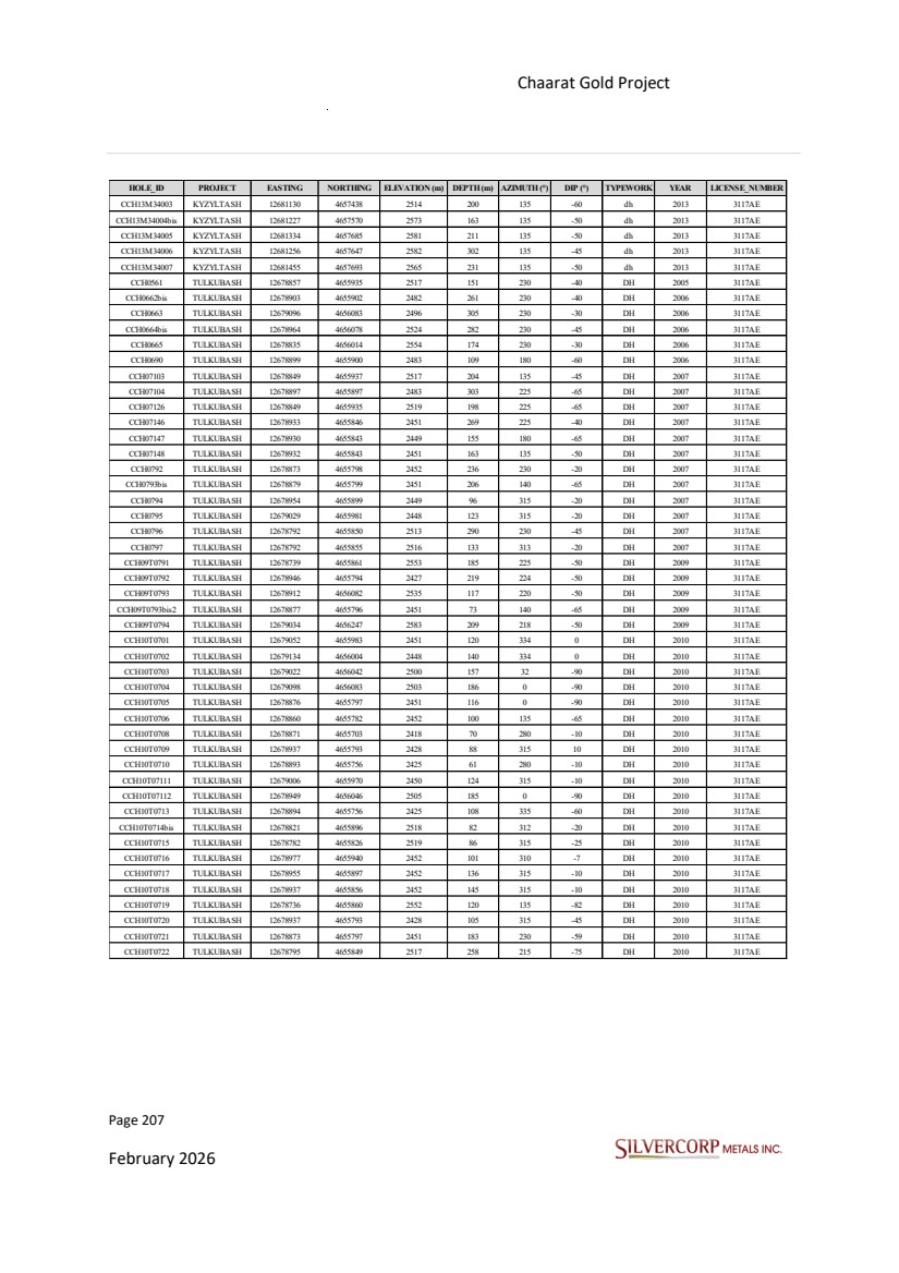
| Page 208 February 2026 Chaarat Gold Project Chatkal district, Kyrgyzstan NI 43-101 Technical Report Mineral Resource Update HOLE_ID PROJECT EASTING NORTHING ELEVATION (m) DEPTH (m) AZIMUTH (°) DIP (°) TYPEWORK YEAR LICENSE_NUMBER CCH10T0723 TULKUBASH 12678932 4656009 2497 70 135 -50 DH 2010 3117AE CCH10T0724 TULKUBASH 12678919 4655976 2493 65 135 -65 DH 2010 3117AE CCH10T0725 TULKUBASH 12678936 4656012 2497 95 135 -80 DH 2011 3117AE CCH10T0726 TULKUBASH 12678892 4656002 2512 139 135 -80 DH 2010 3117AE CCH10T0727 TULKUBASH 12678736 4655861 2553 71 87 -45 DH 2010 3117AE CCH10T0728 TULKUBASH 12678844 4655936 2519 75 315 -20 DH 2010 3117AE CCH10T0729 TULKUBASH 12679175 4656022 2444 130 335 -20 DH 2011 3117AE CCH10T0730 TULKUBASH 12678823 4655897 2518 120 315 -45 DH 2011 3117AE CCH10T0731 TULKUBASH 12678911 4655921 2488 197 315 -20 DH 2011 3117AE CCH10T0732 TULKUBASH 12679341 4656590 2604 203 0 -90 DH 2010 3117AE CCH10T0797bis TULKUBASH 12679018 4656168 2587 185 135 -50 DH 2010 3117AE CCH10UG701 TULKUBASH 12679070 4656031 2451 45 330 34 dh_undg 2010 3117AE CCH10UG702 TULKUBASH 12679047 4656080 2450 50 153 -45 dh_undg 2010 3117AE CCH10UG703 TULKUBASH 12679068 4656033 2449 140 322 -35 dh_undg 2010 3117AE CCH10UG704 TULKUBASH 12679067 4656034 2450 96 310 -22 dh_undg 2010 3117AE CCH10UG705 TULKUBASH 12679067 4656033 2449 145 312 -35 dh_undg 2010 3117AE CCH10UG706 TULKUBASH 12679048 4656081 2451 60 100 0 dh_undg 2010 3117AE CCH10UG707 TULKUBASH 12679048 4656081 2450 69 100 -45 dh_undg 2010 3117AE CCH10UG708 TULKUBASH 12679067 4656035 2449 120 335 -30 dh_undg 2010 3117AE CCH10UG709 TULKUBASH 12679049 4656074 2450 70 155 -40 dh_undg 2010 3117AE CCH11T0701 TULKUBASH 12679025 4655976 2450 180 315 -45 DH 2011 3117AE CCH11T0702 TULKUBASH 12678992 4655959 2451 209 315 -45 DH 2011 3117AE CCH11T0703 TULKUBASH 12679121 4656000 2447 171 315 -45 DH 2011 3117AE CCH11T0704 TULKUBASH 12679026 4655975 2449 158 315 -37 DH 2011 3117AE CCH11T0705 TULKUBASH 12679074 4655984 2450 138 315 -21 DH 2011 3117AE CCH11T0706 TULKUBASH 12678931 4655846 2451 200 315 -25 DH 2011 3117AE CCH11T0707 TULKUBASH 12678847 4655932 2519 194 315 -45 DH 2011 3117AE CCH11T0708 TULKUBASH 12678803 4655859 2517 140 315 -51 DH 2011 3117AE CCH11T0709 TULKUBASH 12678954 4655882 2450 110 315 -41 DH 2011 3117AE CCH11T0710 TULKUBASH 12679288 4656243 2468 146 135 -50 DH 2011 3117AE CCH11T07100 TULKUBASH 12678702 4655851 2556 193 135 -70 DH 2011 3117AE CCH11T07101 TULKUBASH 12679101 4656309 2574 113 315 -45 DH 2011 3117AE CCH11T07102 TULKUBASH 12679033 4656192 2586 170 315 -45 DH 2011 3117AE CCH11T07103 TULKUBASH 12678672 4655825 2563 143 135 -57 DH 2011 3117AE CCH11T07104 TULKUBASH 12678645 4655797 2568 147 135 -52 DH 2011 3117AE CCH11T07105 TULKUBASH 12679101 4656309 2575 50 315 -15 DH 2011 3117AE CCH11T07106 TULKUBASH 12678703 4655848 2556 158 135 -49 DH 2011 3117AE CCH11T07107bis TULKUBASH 12678673 4655825 2562 248 135 -86 DH 2011 3117AE CCH11T07108 TULKUBASH 12679101 4656309 2574 125 315 -56 DH 2011 3117AE CCH11T07109 TULKUBASH 12678559 4655707 2583 208 135 -66 DH 2011 3117AE CCH11T0711 TULKUBASH 12678890 4656001 2512 130 315 -88 DH 2011 3117AE CCH11T07110 TULKUBASH 12679032 4656193 2586 127 315 -15 DH 2011 3117AE CCH11T07111 TULKUBASH 12679152 4656311 2568 57 315 15 DH 2011 3117AE CCH11T07112 TULKUBASH 12678592 4655732 2580 227 135 -82 DH 2011 3117AE CCH11T07113 TULKUBASH 12679014 4656170 2587 164 315 -34 DH 2011 3117AE CCH11T07114 TULKUBASH 12679159 4656331 2563 171 315 -53 DH 2011 3117AE CCH11T07115 TULKUBASH 12678593 4655732 2580 186 135 -72 DH 2011 3117AE CCH11T07116 TULKUBASH 12679015 4656168 2587 50 0 -90 DH 2011 3117AE CCH11T07117 TULKUBASH 12679183 4656382 2562 178 315 -60 DH 2011 3117AE CCH11T07118 TULKUBASH 12678621 4655761 2574 197 135 -70 DH 2011 3117AE CCH11T07119 TULKUBASH 12679159 4656332 2564 91 315 -20 DH 2011 3117AE CCH11T0712 TULKUBASH 12678838 4655828 2483 140 315 -27 DH 2011 3117AE CCH11T07120 TULKUBASH 12679308 4656493 2584 120 315 -20 DH 2011 3117AE CCH11T07121 TULKUBASH 12679284 4656443 2542 87 315 -34 DH 2011 3117AE CCH11T07122 TULKUBASH 12679182 4656383 2562 135 315 -49 DH 2011 3117AE CCH11T07123 TULKUBASH 12679242 4656448 2549 84 315 -45 DH 2011 3117AE CCH11T07124 TULKUBASH 12679211 4656427 2554 115 315 -49 DH 2011 3117AE CCH11T0713 TULKUBASH 12678972 4655919 2451 104 315 -30 DH 2011 3117AE CCH11T0714 TULKUBASH 12678892 4656000 2512 103 135 -71 DH 2011 3117AE |

| Page 209 February 2026 Chaarat Gold Project Chatkal district, Kyrgyzstan NI 43-101 Technical Report Mineral Resource Update HOLE_ID PROJECT EASTING NORTHING ELEVATION (m) DEPTH (m) AZIMUTH (°) DIP (°) TYPEWORK YEAR LICENSE_NUMBER CCH11T0715 TULKUBASH 12678921 4656028 2507 103 315 -74 DH 2011 3117AE CCH11T0716 TULKUBASH 12678830 4655659 2418 120 315 -35 DH 2011 3117AE CCH11T0717 TULKUBASH 12678916 4656064 2526 199 135 -75 DH 2011 3117AE CCH11T0718 TULKUBASH 12678972 4655919 2452 69 315 -10 DH 2011 3117AE CCH11T0719 TULKUBASH 12678887 4655888 2485 108 315 -27 DH 2011 3117AE CCH11T0720 TULKUBASH 12678892 4655999 2512 78 135 -52 DH 2011 3117AE CCH11T0721 TULKUBASH 12678992 4655961 2451 147 315 -30 DH 2011 3117AE CCH11T0722 TULKUBASH 12678921 4656028 2508 60 315 -86 DH 2011 3117AE CCH11T0723 TULKUBASH 12678912 4655923 2487 149 315 -40 DH 2011 3117AE CCH11T0724 TULKUBASH 12679024 4655975 2449 162 315 -30 DH 2011 3117AE CCH11T0725 TULKUBASH 12679031 4656086 2533 81 135 -61 DH 2011 3117AE CCH11T0726 TULKUBASH 12678784 4655934 2555 151 315 -89 DH 2011 3117AE CCH11T0727 TULKUBASH 12679030 4656087 2533 75 135 -89 DH 2011 3117AE CCH11T0728 TULKUBASH 12678980 4656080 2528 103 135 -81 DH 2011 3117AE CCH11T0729 TULKUBASH 12678911 4655923 2488 91 315 -9 DH 2011 3117AE CCH11T0730 TULKUBASH 12679030 4656087 2533 88 135 -79 DH 2011 3117AE CCH11T0731 TULKUBASH 12678981 4656080 2528 112 135 -69 DH 2011 3117AE CCH11T0732 TULKUBASH 12678787 4655932 2555 80 135 -60 DH 2011 3117AE CCH11T0733 TULKUBASH 12678784 4655826 2519 96 315 -39 DH 2011 3117AE CCH11T0734 TULKUBASH 12678992 4655962 2452 101 315 -3 DH 2011 3117AE CCH11T0735 TULKUBASH 12679010 4656167 2588 228 315 -45 DH 2011 3117AE CCH11T0736 TULKUBASH 12678842 4655935 2521 55 315 7 DH 2011 3117AE CCH11T0737 TULKUBASH 12679029 4656089 2533 135 315 -81 DH 2011 3117AE CCH11T0738 TULKUBASH 12678739 4655865 2553 91 315 -67 DH 2011 3117AE CCH11T0739 TULKUBASH 12678769 4655899 2554 61 135 -64 DH 2011 3117AE CCH11T0740 TULKUBASH 12678952 4655881 2453 51 315 10 DH 2011 3117AE CCH11T0741 TULKUBASH 12679076 4655984 2449 171 315 -30 DH 2011 3117AE CCH11T0742 TULKUBASH 12679023 4655976 2450 82 315 -11 DH 2011 3117AE CCH11T0743 TULKUBASH 12678739 4655864 2553 212 315 -85 DH 2011 3117AE CCH11T0744 TULKUBASH 12678968 4656036 2500 69 135 -60 DH 2011 3117AE CCH11T0745 TULKUBASH 12678991 4655962 2453 93 315 12 DH 2011 3117AE CCH11T0746 TULKUBASH 12678556 4655710 2584 101 315 -34 DH 2011 3117AE CCH11T0747 TULKUBASH 12678617 4655763 2574 111 315 -35 DH 2011 3117AE CCH11T0748 TULKUBASH 12678668 4655826 2563 107 315 -80 DH 2011 3117AE CCH11T0749 TULKUBASH 12679017 4656047 2501 45 135 -67 DH 2011 3117AE CCH11T0750 TULKUBASH 12679010 4656048 2501 41 315 -26 DH 2011 3117AE CCH11T0751 TULKUBASH 12678798 4655859 2517 124 315 -43 DH 2011 3117AE CCH11T0752 TULKUBASH 12678766 4655898 2554 91 135 -86 DH 2011 3117AE CCH11T0753 TULKUBASH 12678666 4655827 2563 105 315 -30 DH 2011 3117AE CCH11T0754 TULKUBASH 12679068 4656033 2449 173 315 -58 dh_undg 2011 3117AE CCH11T0755 TULKUBASH 12679068 4656034 2449 124 315 -48 dh_undg 2011 3117AE CCH11T0756 TULKUBASH 12679152 4656308 2565 181 315 -45 DH 2011 3117AE CCH11T0757 TULKUBASH 12678993 4655962 2451 141 315 -24 DH 2011 3117AE CCH11T0758 TULKUBASH 12678742 4655864 2553 170 135 -89 DH 2011 3117AE CCH11T0759 TULKUBASH 12678619 4655761 2574 78 315 -75 DH 2011 3117AE CCH11T0760bis TULKUBASH 12678555 4655710 2584 57 315 -22 DH 2011 3117AE CCH11T0761 TULKUBASH 12679075 4655985 2449 151 315 -12 DH 2011 3117AE CCH11T0762 TULKUBASH 12678838 4655827 2484 117 315 -17 DH 2011 3117AE CCH11T0763 TULKUBASH 12678956 4656080 2527 121 135 -85 DH 2011 3117AE |
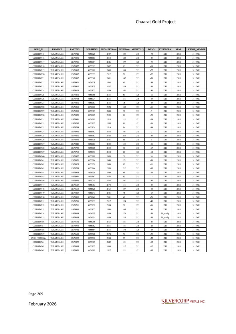
| Page 210 February 2026 Chaarat Gold Project Chatkal district, Kyrgyzstan NI 43-101 Technical Report Mineral Resource Update HOLE_ID PROJECT EASTING NORTHING ELEVATION (m) DEPTH (m) AZIMUTH (°) DIP (°) TYPEWORK YEAR LICENSE_NUMBER CCH11T0764 TULKUBASH 12678740 4655866 2553 71 315 -74 DH 2011 3117AE CCH11T0765 TULKUBASH 12678844 4655933 2518 114 315 -36 DH 2011 3117AE CCH11T0766 TULKUBASH 12678788 4655835 2519 121 315 -59 DH 2011 3117AE CCH11T0767 TULKUBASH 12678992 4655962 2451 111 315 -15 DH 2011 3117AE CCH11T0768 TULKUBASH 12678956 4656079 2528 90 135 -80 DH 2011 3117AE CCH11T0769 TULKUBASH 12679308 4656491 2583 180 315 -45 DH 2011 3117AE CCH11T0770 TULKUBASH 12678929 4655848 2452 182 315 -18 DH 2011 3117AE CCH11T0771 TULKUBASH 12678753 4655877 2554 77 315 -75 DH 2011 3117AE CCH11T0772 TULKUBASH 12678787 4655835 2519 101 315 -54 DH 2011 3117AE CCH11T0773 TULKUBASH 12678848 4655932 2518 72 135 -68 DH 2011 3117AE CCH11T0774 TULKUBASH 12678954 4655881 2451 98 315 -26 DH 2011 3117AE CCH11T0775 TULKUBASH 12678957 4656079 2527 71 135 -68 DH 2011 3117AE CCH11T0776 TULKUBASH 12678890 4655892 2485 107 312 -13 DH 2011 3117AE CCH11T0777 TULKUBASH 12678753 4655877 2554 76 315 -66 DH 2011 3117AE CCH11T0778 TULKUBASH 12678957 4656078 2528 60 135 -50 DH 2011 3117AE CCH11T0779 TULKUBASH 12679048 4655981 2451 112 315 -16 DH 2011 3117AE CCH11T0780 TULKUBASH 12678787 4655836 2519 81 315 -45 DH 2011 3117AE CCH11T0781 TULKUBASH 12679013 4656172 2588 128 315 -12 DH 2011 3117AE CCH11T0782 TULKUBASH 12678757 4655878 2554 51 135 -82 DH 2011 3117AE CCH11T0783 TULKUBASH 12678881 4655953 2517 40 0 -90 DH 2011 3117AE CCH11T0784 TULKUBASH 12679042 4655977 2449 137 315 -33 DH 2011 3117AE CCH11T0785 TULKUBASH 12679048 4655981 2451 115 315 -25 DH 2011 3117AE CCH11T0786 TULKUBASH 12678911 4655923 2487 89 315 -24 DH 2011 3117AE CCH11T0787 TULKUBASH 12678560 4655705 2583 183 135 -52 DH 2011 3117AE CCH11T0788 TULKUBASH 12678987 4656045 2503 60 135 -69 DH 2011 3117AE CCH11T0789 TULKUBASH 12678593 4655731 2580 160 135 -58 DH 2011 3117AE CCH11T0790 TULKUBASH 12678622 4655758 2574 140 135 -53 DH 2011 3117AE CCH11T0791 TULKUBASH 12678988 4656044 2503 57 135 -50 DH 2011 3117AE CCH11T0792 TULKUBASH 12679153 4656312 2566 112 315 -20 DH 2011 3117AE CCH11T0793 TULKUBASH 12679015 4656170 2587 204 315 -49 DH 2011 3117AE CCH11T0794 TULKUBASH 12678643 4655796 2569 157 135 -69 DH 2011 3117AE CCH11T0795bis TULKUBASH 12678671 4655825 2563 178 135 -75 DH 2011 3117AE CCH11T0796 TULKUBASH 12678702 4655851 2556 198 135 -84 DH 2011 3117AE CCH11T0797 TULKUBASH 12679159 4656331 2563 143 315 -45 DH 2011 3117AE CCH11T0798 TULKUBASH 12678643 4655796 2568 205 135 -81 DH 2011 3117AE CCH11T0799 TULKUBASH 12678559 4655707 2583 237 135 -77 DH 2011 3117AE CCH12T07125 TULKUBASH 12679202 4656310 2531 227 315 -43 DH 2012 3117AE CCH12T07126 TULKUBASH 12679215 4656356 2529 147 315 -33 DH 2012 3117AE CCH12T07127 TULKUBASH 12679335 4656405 2515 168 315 -43 DH 2012 3117AE CCH12T07128 TULKUBASH 12679335 4656406 2515 138 315 -29 DH 2012 3117AE CCH12T07129 TULKUBASH 12679201 4656310 2531 161 315 -31 DH 2012 3117AE CCH12T07130 TULKUBASH 12679241 4656385 2526 149 315 -43 DH 2012 3117AE CCH12T07131 TULKUBASH 12679334 4656407 2515 124 315 -13 DH 2012 3117AE CCH12T07132Bis TULKUBASH 12679139 4656263 2536 101 315 -1 DH 2012 3117AE CCH12T07133BIS TULKUBASH 12679101 4656186 2535 168 315 3 DH 2012 3117AE CCH12T07134 TULKUBASH 12679194 4656273 2533 176 315 -25 DH 2012 3117AE CCH12T07135 TULKUBASH 12679242 4656384 2526 181 315 -50 DH 2012 3117AE CCH12T07136 TULKUBASH 12679103 4656242 2535 197 315 -49 DH 2012 3117AE CCH12T07137bis TULKUBASH 12679102 4656185 2533 211 315 -28 DH 2012 3117AE CCH12T07138 TULKUBASH 12679057 4656108 2534 249 316 -31 DH 2012 3117AE CCH12T07139 TULKUBASH 12679140 4656265 2534 193 315 -43 DH 2012 3117AE CCH12T07140 TULKUBASH 12679194 4656272 2532 231 315 -43 DH 2012 3117AE CCH12T07141 TULKUBASH 12679241 4656384 2526 183 315 -55 DH 2012 3117AE CCH12T07142 TULKUBASH 12679103 4656242 2535 153 315 -43 DH 2012 3117AE CCH12T07143 TULKUBASH 12679140 4656264 2534 210 315 -50 DH 2012 3117AE CCH12T07144 TULKUBASH 12679091 4656136 2532 248 315 -43 DH 2012 3117AE CCH12T07145 TULKUBASH 12679203 4656309 2531 247 315 -50 DH 2012 3117AE CCH12T07146 TULKUBASH 12679103 4656184 2533 230 315 -43 DH 2012 3117AE CCH12T07147 TULKUBASH 12679140 4656264 2535 161 315 -25 DH 2012 3117AE |

| Page 211 February 2026 Chaarat Gold Project Chatkal district, Kyrgyzstan NI 43-101 Technical Report Mineral Resource Update HOLE_ID PROJECT EASTING NORTHING ELEVATION (m) DEPTH (m) AZIMUTH (°) DIP (°) TYPEWORK YEAR LICENSE_NUMBER CCH12T07148 TULKUBASH 12679240 4656387 2526 109 315 -17 DH 2012 3117AE CCH12T07149 TULKUBASH 12679057 4656109 2534 226 315 -24 DH 2012 3117AE CCH12T07150 TULKUBASH 12679102 4656245 2535 160 315 -30 DH 2012 3117AE CCH12T07151 TULKUBASH 12679217 4656355 2529 198 315 -45 DH 2012 3117AE CCH12T07152 TULKUBASH 12679089 4656137 2533 205 315 -30 DH 2012 3117AE CCH12T07153 TULKUBASH 12679273 4656407 2522 123 315 -13 DH 2012 3117AE CCH12T07154 TULKUBASH 12679101 4656184 2534 174 315 -15 DH 2012 3117AE CCH12T07155 TULKUBASH 12679101 4656245 2537 110 315 -7 DH 2012 3117AE CCH12T07156 TULKUBASH 12679056 4656110 2534 187 315 -12 DH 2012 3117AE CCH12T07157 TULKUBASH 12679213 4656357 2531 102 315 -8 DH 2012 3117AE CCH12T07158 TULKUBASH 12679089 4656137 2534 177 315 -15 DH 2012 3117AE CCH12T07159 TULKUBASH 12679274 4656406 2521 132 315 -43 DH 2012 3117AE CCH12T07160 TULKUBASH 12679274 4656404 2521 166 315 -49 DH 2012 3117AE CCH12T07161 TULKUBASH 12679089 4656138 2535 109 315 9 DH 2012 3117AE CCH12T07162 TULKUBASH 12679404 4656571 2601 200 315 -15 DH 2012 3117AE CCH12T07163 TULKUBASH 12679290 4656442 2543 210 338 -10 DH 2012 3117AE CCH13T07164 TULKUBASH 12679038 4656246 2583 52 135 -55 d h 2013 3117AE CCH13T07165 TULKUBASH 12679053 4656294 2579 49 135 -75 d h 2013 3117AE CCH13T07166 TULKUBASH 12679194 4656273 2533 212 315 -35 d h 2013 3117AE CCH13T07167 TULKUBASH 12679203 4656547 2618 211 135 -65 d h 2013 3117AE CCH13T07168 TULKUBASH 12679109 4656456 2634 105 135 -58 d h 2013 3117AE CCH13T07169 TULKUBASH 12679094 4656418 2634 115 135 -65 d h 2013 3117AE CCH13T07170 TULKUBASH 12679082 4656384 2633 86 135 -65 d h 2013 3117AE CCH13T07171 TULKUBASH 12679207 4656475 2573 121 135 -60 d h 2013 3117AE CCH13T07172 TULKUBASH 12679031 4656374 2637 89 135 -60 d h 2013 3117AE CCH13T07173 TULKUBASH 12678973 4656366 2644 120 135 -45 d h 2013 3117AE CCH13T07174 TULKUBASH 12679190 4656440 2569 104 135 -67 d h 2013 3117AE CCH13T07175 TULKUBASH 12678958 4656269 2543 180 135 -60 d h 2013 3117AE CCH13T07176 TULKUBASH 12678960 4656327 2647 254 135 -65 d h 2013 3117AE CCH13T0793bis3 TULKUBASH 12678877 4655796 2451 84 140 -65 d h 2013 3117AE CCH14T07177 TULKUBASH 12679380 4656583 2605 150 315 -20 d h 2014 3117AE CCH14T07178 TULKUBASH 12680253 4657377 2751 152 315 -30 d h 2014 3117AE CCH14T07179 TULKUBASH 12680065 4657089 2749 200 315 -20 d h 2014 3117AE CCH14T07180 TULKUBASH 12679385 4656577 2603 70 135 -60 d h 2014 3117AE CCH14T07181 TULKUBASH 12680257 4657377 2750 90 135 -65 d h 2014 3117AE CCH14T07183 TULKUBASH 12678835 4656025 2554 70 135 -61 d h 2014 3117AE CCH14T07185 TULKUBASH 12679341 4656588 2604 91 135 -45 d h 2014 3117AE CCH14T07188 TULKUBASH 12679422 4656655 2668 140 135 -45 d h 2014 3117AE CCH14T07190 TULKUBASH 12679335 4656592 2604 93 315 -30 d h 2014 3117AE CCH14T07192 TULKUBASH 12679422 4656656 2668 162 135 -75 d h 2014 3117AE CCH14T07199 TULKUBASH 12679358 4656672 2663 119 135 -45 d h 2014 3117AE CCH14T07206 TULKUBASH 12679357 4656673 2663 168 135 -70 d h 2014 3117AE CCH14T07222 TULKUBASH 12679341 4656588 2604 114 135 -75 d h 2014 3117AE CCH14T07223 TULKUBASH 12679353 4656674 2663 160 170 -65 d h 2014 3117AE CCH14T24182 TULKUBASH 12679647 4656940 2811 175 135 -45 d h 2014 3117AE CCH14T24184bis TULKUBASH 12679863 4657161 2795 174 135 -45 d h 2014 3117AE CCH14T24186 TULKUBASH 12679729 4657085 2779 175 135 -50 d h 2014 3117AE CCH14T24187 TULKUBASH 12679665 4657094 2811 225 135 -45 d h 2014 3117AE CCH14T24189 TULKUBASH 12679646 4656941 2811 156 135 -70 d h 2014 3117AE CCH14T24191 TULKUBASH 12679729 4657085 2779 185 135 -70 d h 2014 3117AE CCH14T24193 TULKUBASH 12679664 4657094 2810 234 135 -60 d h 2014 3117AE CCH14T24194 TULKUBASH 12679648 4657055 2810 200 135 -35 d h 2014 3117AE CCH14T24195 TULKUBASH 12679808 4657124 2768 79 135 -50 d h 2014 3117AE CCH14T24196 TULKUBASH 12679823 4657163 2794 65 135 -45 d h 2014 3117AE CCH14T24197 TULKUBASH 12679646 4656989 2808 69 135 -45 d h 2014 3117AE CCH14T24198 TULKUBASH 12679647 4657057 2810 103 135 -60 d h 2014 3117AE CCH14T24200 TULKUBASH 12679645 4656990 2808 100 135 -75 d h 2014 3117AE CCH14T24201 TULKUBASH 12679819 4657164 2793 80 0 -90 d h 2014 3117AE CCH14T24201bis TULKUBASH 12679821 4657165 2793 100 0 -90 d h 2014 3117AE |
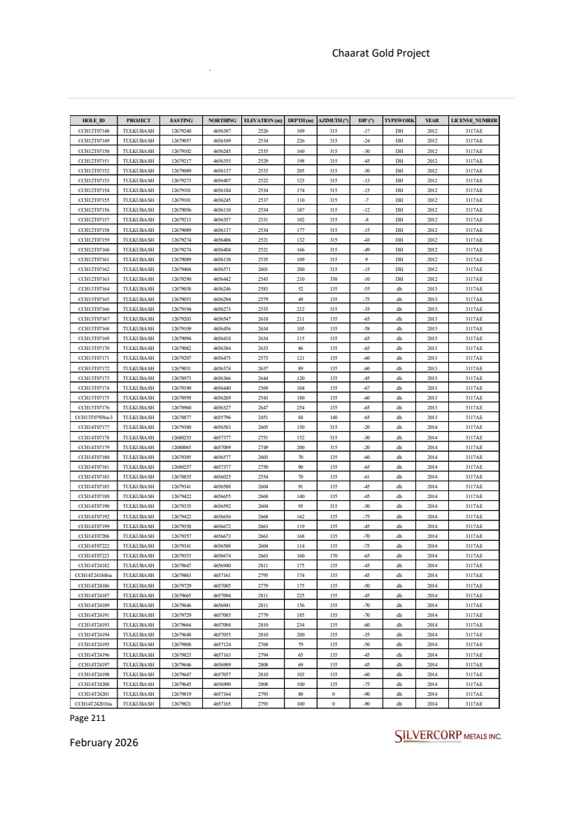
| Page 212 February 2026 Chaarat Gold Project Chatkal district, Kyrgyzstan NI 43-101 Technical Report Mineral Resource Update HOLE_ID PROJECT EASTING NORTHING ELEVATION (m) DEPTH (m) AZIMUTH (°) DIP (°) TYPEWORK YEAR LICENSE_NUMBER CCH14T24202 TULKUBASH 12679801 4656905 2692 101 315 -25 d h 2014 3117AE CCH14T24203 TULKUBASH 12679862 4657163 2795 201 135 -55 d h 2014 3117AE CCH14T24204 TULKUBASH 12679640 4656995 2809 72 315 -30 d h 2014 3117AE CCH14T24205 TULKUBASH 12679880 4657048 2719 121 0 -90 d h 2014 3117AE CCH14T24207 TULKUBASH 12679602 4656874 2827 131 315 -25 d h 2014 3117AE CCH14T24209 TULKUBASH 12679880 4657048 2719 51 135 -60 d h 2014 3117AE CCH14T24210 TULKUBASH 12679778 4656981 2723 82 135 -45 d h 2014 3117AE CCH14T24211 TULKUBASH 12679832 4657044 2720 127 135 -80 d h 2014 3117AE CCH14T24212 TULKUBASH 12679903 4657091 2750 74 135 -72 d h 2014 3117AE CCH14T24213 TULKUBASH 12679648 4656824 2795 110 135 -50 d h 2014 3117AE CCH14T24214 TULKUBASH 12679646 4657053 2810 90 0 -90 d h 2014 3117AE CCH14T24215 TULKUBASH 12679777 4656983 2723 106 135 -65 d h 2014 3117AE CCH14T24216 TULKUBASH 12679665 4657097 2811 124 0 -90 d h 2014 3117AE CCH14T24217 TULKUBASH 12679861 4657163 2795 80 0 -90 d h 2014 3117AE CCH14T24218 TULKUBASH 12679780 4656864 2704 115 315 -25 d h 2014 3117AE CCH14T24219 TULKUBASH 12679647 4656824 2795 130 135 -75 d h 2014 3117AE CCH14T24220 TULKUBASH 12679952 4657080 2750 26 135 -45 d h 2014 3117AE CCH14T24221 TULKUBASH 12679727 4657086 2779 120 0 -90 d h 2014 3117AE CCH17T07229bis TULKUBASH 12678710 4655784 2526 153 135 -60 DH 2017 3117AE CCH17T07230 TULKUBASH 12678904 4656087 2534 50 315 -20 DH 2017 3117AE CCH17T07231 TULKUBASH 12678825 4656128 2599 80 135 -45 DH 2017 3117AE CCH17T07232 TULKUBASH 12679072 4656380 2633 130 0 -90 DH 2017 3117AE CCH17T07233 TULKUBASH 12678957 4656277 2644 94 0 -90 DH 2017 3117AE CCH17T07236 TULKUBASH 12678911 4656087 2534 20 135 -60 DH 2017 3117AE CCH17T07237 TULKUBASH 12678877 4656070 2542 45 135 -50 DH 2017 3117AE CCH17T07238 TULKUBASH 12679126 4656538 2626 102 135 -60 DH 2017 3117AE CCH17T07238bis TULKUBASH 12679125 4656538 2625 150 135 -65 DH 2017 3117AE CCH17T07239 TULKUBASH 12678972 4656369 2645 140 135 -60 DH 2017 3117AE CCH17T07240 TULKUBASH 12679462 4656867 2822 148 135 -65 DH 2017 3117AE CCH17T07241 TULKUBASH 12679094 4656420 2634 144 0 -90 DH 2017 3117AE CCH17T07242 TULKUBASH 12679438 4656867 2820 127 135 -45 DH 2017 3117AE CCH17T07243 TULKUBASH 12679110 4656497 2631 140 135 -60 DH 2017 3117AE CCH17T07244 TULKUBASH 12679576 4656850 2823 150 135 -55 DH 2017 3117AE CCH17T07245 TULKUBASH 12679529 4656777 2779 64 135 -70 DH 2017 3117AE CCH17T07245bis TULKUBASH 12679530 4656777 2781 160 135 -70 DH 2017 3117AE CCH17T07246 TULKUBASH 12679511 4656853 2826 43 135 -62 DH 2017 3117AE CCH17T07246bis TULKUBASH 12679513 4656851 2826 85 135 -62 DH 2017 3117AE CCH17T07246bis 2 TULKUBASH 12679510 4656850 2826 216 135 -65 DH 2017 3117AE CCH17T07247 TULKUBASH 12679363 4656907 2809 180 135 -45 DH 2017 3319AP CCH17T07248 TULKUBASH 12679079 4656389 2635 97 315 -20 DH 2017 3117AE CCH17T07249 TULKUBASH 12679570 4656797 2784 114 135 -60 DH 2017 3117AE CCH17T07250 TULKUBASH 12678957 4656267 2643 55 135 -45 DH 2017 3117AE CCH17T07252 TULKUBASH 12678842 4656166 2599 100 135 -45 DH 2017 3117AE CCH17T07253 TULKUBASH 12678953 4656276 2644 110 315 -25 DH 2017 3117AE CCH17T07255 TULKUBASH 12679473 4656787 2771 75 135 -45 DH 2017 3117AE CCH17T07255bis TULKUBASH 12679472 4656787 2771 160 135 -45 DH 2017 3117AE CCH17T07260 TULKUBASH 12678877 4656189 2599 115 135 -45 DH 2017 3117AE CCH17T07261 TULKUBASH 12678824 4656128 2600 110 135 -70 DH 2017 3117AE CCH17T07262 TULKUBASH 12678878 4656068 2542 111 135 -75 DH 2017 3117AE CCH17T07263 TULKUBASH 12679578 4656855 2823 193 135 -70 DH 2017 3117AE CCH17T07264 TULKUBASH 12679519 4656625 2674 115 315 -30 DH 2017 3117AE CCH17T07265 TULKUBASH 12679758 4657168 2797 56 135 -45 DH 2017 3117AE CCH17T07265bis TULKUBASH 12679759 4657170 2797 96 135 -45 DH 2017 3117AE CCH17T07266 TULKUBASH 12678960 4656324 2647 140 135 -80 DH 2017 3117AE CCH17T07267 TULKUBASH 12679032 4656375 2637 130 135 -80 DH 2017 3117AE CCH17T07268 TULKUBASH 12679577 4656616 2672 177 315 -30 DH 2017 3117AE CCH17T07269 TULKUBASH 12678776 4656110 2602 105 135 -45 DH 2017 3117AE CCH17T07270 TULKUBASH 12679695 4656951 2771 119 0 -90 DH 2017 3117AE CCH17T07271 TULKUBASH 12678842 4656170 2599 80 135 -75 DH 2017 3117AE |
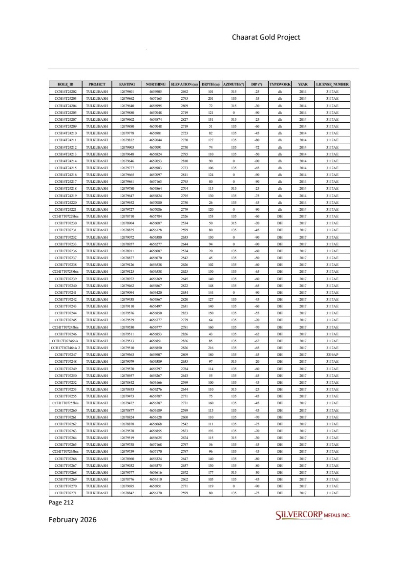
| Page 213 February 2026 Chaarat Gold Project Chatkal district, Kyrgyzstan NI 43-101 Technical Report Mineral Resource Update HOLE_ID PROJECT EASTING NORTHING ELEVATION (m) DEPTH (m) AZIMUTH (°) DIP (°) TYPEWORK YEAR LICENSE_NUMBER CCH17T07272 TULKUBASH 12679716 4657155 2803 130 135 -60 DH 2017 3117AE CCH17T07273 TULKUBASH 12679702 4656994 2770 85 135 -75 DH 2017 3117AE CCH17T07274 TULKUBASH 12678710 4655783 2526 245 135 -75 DH 2017 3117AE CCH17T07275 TULKUBASH 12679419 4656787 2765 173 135 -45 DH 2017 3117AE CCH17T07276 TULKUBASH 12679247 4656603 2659 250 135 -50 DH 2017 3117AE CCH17T07277 TULKUBASH 12679077 4656382 2633 105 315 -45 DH 2017 3117AE CCH17T07278 TULKUBASH 12680021 4657134 2792 106 135 -50 DH 2017 3117AE CCH17T07279 TULKUBASH 12678801 4655640 2422 164 315 -30 DH 2017 3117AE CCH17T07280 TULKUBASH 12679874 4657224 2840 76 135 -70 DH 2017 3117AE CCH17T07281 TULKUBASH 12678876 4656187 2599 149 135 -65 DH 2017 3117AE CCH17T07282 TULKUBASH 12679677 4657135 2810 145 135 -45 DH 2017 3117AE CCH17T07283 TULKUBASH 12679821 4657230 2836 110 135 -45 DH 2017 3117AE CCH17T07284 TULKUBASH 12679471 4656789 2771 195 135 -65 DH 2017 3117AE CCH17T07285 TULKUBASH 12679531 4656774 2779 150 135 -50 DH 2017 3117AE CCH17T07286 TULKUBASH 12679606 4656868 2826 116 135 -55 DH 2017 3117AE CCH17T07287 TULKUBASH 12679698 4656949 2771 77 135 -50 DH 2017 3117AE CCH17T07288 TULKUBASH 12679638 4656884 2805 87 135 -55 DH 2017 3117AE CCH17T07289 TULKUBASH 12679869 4657228 2841 65 315 -30 DH 2017 3117AE CCH17T07290 TULKUBASH 12679522 4656623 2673 200 315 -50 DH 2017 3117AE CCH17T07291 TULKUBASH 12679281 4656687 2666 66 135 -50 DH 2017 3117AE CCH17T07291bis TULKUBASH 12679282 4656687 2666 231 135 -50 DH 2017 3117AE CCH17T07292 TULKUBASH 12680015 4657139 2793 48 315 -30 DH 2017 3117AE CCH17T07293 TULKUBASH 12679158 4656585 2650 287 135 -65 DH 2017 3117AE CCH17T07294 TULKUBASH 12679199 4656601 2656 141 135 -65 DH 2017 3117AE CCH17T07295 TULKUBASH 12679263 4656639 2660 70 135 -60 DH 2017 3117AE CCH17T07295bis TULKUBASH 12679264 4656640 2660 138 135 -60 DH 2017 3117AE CCH17T07296 TULKUBASH 12679307 4656491 2583 62 135 -75 DH 2017 3117AE CCH17T07297 TULKUBASH 12679384 4656417 2509 168 315 -25 DH 2017 3117AE CCH17T07299 TULKUBASH 12679961 4657141 2794 130 135 -70 DH 2017 3117AE CCH17T07300 TULKUBASH 12679719 4657159 2802 138 135 -75 DH 2017 3117AE CCH17T07301 TULKUBASH 12679943 4657215 2840 150 315 -45 DH 2017 3117AE CCH17T07302bis TULKUBASH 12680007 4657207 2849 195 135 -65 DH 2017 3117AE CCH17T07303 TULKUBASH 12678798 4655641 2422 170 315 -45 DH 2017 3117AE CCH17T07304 TULKUBASH 12678770 4655622 2425 155 315 -30 DH 2017 3117AE CCH17T07305 TULKUBASH 12679619 4656904 2819 145 135 -65 DH 2017 3117AE CCH17T07306 TULKUBASH 12679677 4657138 2811 195 135 -70 DH 2017 3319AP CCH17T07307 TULKUBASH 12678871 4655704 2417 178 315 -45 DH 2017 3117AE CCH17T07308 TULKUBASH 12679756 4657167 2797 155 155 -70 DH 2017 3117AE CCH17T07309 TULKUBASH 12679060 4656105 2534 128 135 -70 DH 2017 3117AE CCH17T07310 TULKUBASH 12678703 4655851 2556 315 135 -55 DH 2017 3117AE CCH17T07311 TULKUBASH 12680049 4657224 2853 51 135 -75 DH 2017 3117AE CCH17T07311bis TULKUBASH 12680053 4657225 2853 135 135 -75 DH 2017 3117AE CCH17T07313 TULKUBASH 12678923 4656252 2650 133 135 -70 DH 2017 3117AE CCH17T07314 TULKUBASH 12678925 4656180 2596 156 135 -55 DH 2017 3117AE CCH17T07315 TULKUBASH 12678772 4655619 2425 180 315 -50 DH 2017 3117AE CCH17T07316 TULKUBASH 12678889 4655753 2425 95 315 -30 DH 2017 3117AE CCH17T07317 TULKUBASH 12679573 4656796 2786 143 135 -45 DH 2017 3117AE CCH17T07318 TULKUBASH 12679784 4657205 2821 100 135 -55 DH 2017 3117AE CCH17T07319 TULKUBASH 12678783 4655927 2554 192 135 -75 DH 2017 3117AE CCH17T07320 TULKUBASH 12678742 4655592 2425 137 315 -45 DH 2017 3117AE CCH17T07321 TULKUBASH 12679205 4656767 2749 127 135 -50 DH 2017 3319AP CCH17T07322 TULKUBASH 12678835 4656026 2554 120 135 -80 DH 2017 3117AE CCH17T07323 TULKUBASH 12679942 4657215 2840 105 315 -30 DH 2017 3117AE CCH17T07324 TULKUBASH 12678776 4656110 2602 140 135 -65 DH 2017 3117AE CCH17T07325 TULKUBASH 12679875 4657222 2840 120 135 -50 DH 2017 3117AE CCH17T07326 TULKUBASH 12679958 4657142 2794 112 135 -50 DH 2017 3117AE CCH17T07327 TULKUBASH 12680003 4657211 2849 224 315 -45 DH 2017 3117AE CCH17T07328 TULKUBASH 12679183 4656723 2747 207 135 -50 DH 2017 3117AE CCH17T07329 TULKUBASH 12678702 4655548 2426 135 315 -45 DH 2017 3117AE |

| Page 214 February 2026 Chaarat Gold Project Chatkal district, Kyrgyzstan NI 43-101 Technical Report Mineral Resource Update HOLE_ID PROJECT EASTING NORTHING ELEVATION (m) DEPTH (m) AZIMUTH (°) DIP (°) TYPEWORK YEAR LICENSE_NUMBER CCH17T07330 TULKUBASH 12679587 4656955 2853 48 136 -65 DH 2017 3117AE CCH17T07330bis TULKUBASH 12679586 4656955 2853 102 135 -65 DH 2017 3117AE CCH17T07331 TULKUBASH 12679791 4657014 2725 112 135 -55 DH 2017 3117AE CCH17T07332 TULKUBASH 12680081 4657243 2856 18 315 -25 DH 2017 3117AE CCH17T07333bis TULKUBASH 12679241 4656962 2799 174 135 -60 DH 2017 3319AP CCH17T07334 TULKUBASH 12680047 4657229 2853 62 135 -50 DH 2017 3117AE CCH17T07335 TULKUBASH 12678739 4655594 2426 128 315 -25 DH 2017 3117AE CCH17T07336 TULKUBASH 12678681 4655518 2427 130 315 -45 DH 2017 3117AE CCH17T07337 TULKUBASH 12679144 4656259 2534 196 135 -55 DH 2017 3117AE CCH17T07338 TULKUBASH 12679251 4656774 2720 123 135 -45 DH 2017 3319AP CCH17T07339 TULKUBASH 12680179 4657313 2798 36 135 -50 DH 2017 3117AE CCH17T07340 TULKUBASH 12680070 4657145 2792 58 135 -60 DH 2017 3117AE CCH17T07341 TULKUBASH 12678925 4656180 2596 209 135 -65 DH 2017 3117AE CCH17T07342 TULKUBASH 12679188 4656690 2730 143 135 -45 DH 2017 3117AE CCH17T07343 TULKUBASH 12679293 4656796 2714 131 135 -45 DH 2017 3319AP CCH17T07344 TULKUBASH 12679326 4656701 2669 127 135 -65 DH 2017 3117AE CCH17T07345 TULKUBASH 12679366 4656760 2723 215 135 -55 DH 2017 3117AE CCH17T07346 TULKUBASH 12679279 4656861 2747 140 135 -35 DH 2017 3319AP CCH17T07347 TULKUBASH 12679246 4656604 2659 247 135 -70 DH 2017 3117AE CCH17T07348 TULKUBASH 12679200 4656599 2656 182 135 -70 DH 2017 3117AE CCH17T07349 TULKUBASH 12680084 4657244 2856 260 315 -40 DH 2017 3117AE CCH17T07350 TULKUBASH 12680114 4657155 2793 62 135 -65 DH 2017 3117AE CCH17T07351 TULKUBASH 12680049 4657224 2853 49 315 -40 DH 2017 3117AE CCH17T07352 TULKUBASH 12679329 4656698 2669 172 120 -45 DH 2017 3117AE CCH17T24234 TULKUBASH 12679801 4656900 2691 114 315 -35 DH 2017 3117AE CCH17T24235 TULKUBASH 12679865 4657113 2759 106 0 -90 DH 2017 3117AE CCH17T24251 TULKUBASH 12679636 4656888 2804 86 0 -90 DH 2017 3117AE CCH17T24254 TULKUBASH 12679781 4657205 2821 139 135 -70 DH 2017 3117AE CCH17T24256bis TULKUBASH 12679778 4656862 2705 130 315 -25 DH 2017 3117AE CCH17T24257 TULKUBASH 12679757 4657169 2797 119 135 -60 DH 2017 3117AE CCH17T24258 TULKUBASH 12679642 4656830 2796 133 315 -30 DH 2017 3117AE CCH17T24259 TULKUBASH 12679822 4657227 2836 173 135 -70 DH 2017 3117AE CH18I001 TULKUBASH 12677963 4655434 2410 100 0 -90 DH 2018 3117AE CH18I002 TULKUBASH 12677874 4655657 2465 100 0 -90 DH 2018 3117AE CH18I003 TULKUBASH 12677875 4655783 2495 101 0 -90 DH 2018 3117AE DH18T353 TULKUBASH 12679096 4656135 2532 130 135 -60 DH 2018 3117AE DH18T354 TULKUBASH 12679107 4656182 2533 125 135 -60 DH 2018 3117AE DH18T355 TULKUBASH 12680020 4657293 2897 150 315 -45 DH 2018 3117AE DH18T356 TULKUBASH 12680084 4657239 2855 49 135 -75 DH 2018 3117AE DH18T356bis TULKUBASH 12680084 4657240 2855 214 135 -75 DH 2018 3117AE DH18T357 TULKUBASH 12679106 4656241 2535 121 135 -60 DH 2018 3117AE DH18T358 TULKUBASH 12680157 4657167 2793 20 135 -55 DH 2018 3117AE DH18T358bis TULKUBASH 12680157 4657167 2793 29 135 -55 DH 2018 3117AE DH18T359 TULKUBASH 12680104 4657332 2853 192 135 -50 DH 2018 3117AE DH18T360 TULKUBASH 12680187 4657356 2800 130 135 -55 DH 2018 3117AE DH18T361 TULKUBASH 12680180 4657479 2803 47 135 -55 DH 2018 3117AE DH18T362 TULKUBASH 12680179 4657480 2803 165 135 -75 DH 2018 3117AE DH18T363 TULKUBASH 12680157 4657168 2793 123 135 -75 DH 2018 3117AE DH18T364 TULKUBASH 12680350 4657762 2853 183 135 -75 DH 2018 3117AE DH18T365 TULKUBASH 12680278 4657849 2914 179 135 -75 DH 2018 3117AE DH18T366 TULKUBASH 12680176 4657576 2820 229 135 -80 DH 2018 3117AE DH18T367 TULKUBASH 12680469 4657648 2759 173 135 -75 DH 2018 3117AE DH18T368 TULKUBASH 12680276 4657509 2754 186 135 -75 DH 2018 3117AE DH18T369 TULKUBASH 12680350 4657761 2853 162 135 -50 DH 2018 3117AE DH18T370 TULKUBASH 12679196 4656268 2532 154 135 -65 DH 2018 3117AE DH18T371 TULKUBASH 12680679 4657992 2991 240 135 -55 DH 2018 3117AE DH18T372 TULKUBASH 12680407 4657827 2856 30 135 -50 DH 2018 3117AE DH18T373 TULKUBASH 12680406 4657828 2856 275 135 -75 DH 2018 3117AE DH18T374 TULKUBASH 12680172 4657254 2795 116 135 -70 DH 2018 3117AE DH18T375 TULKUBASH 12680185 4657357 2800 51 135 -75 DH 2018 3117AE |
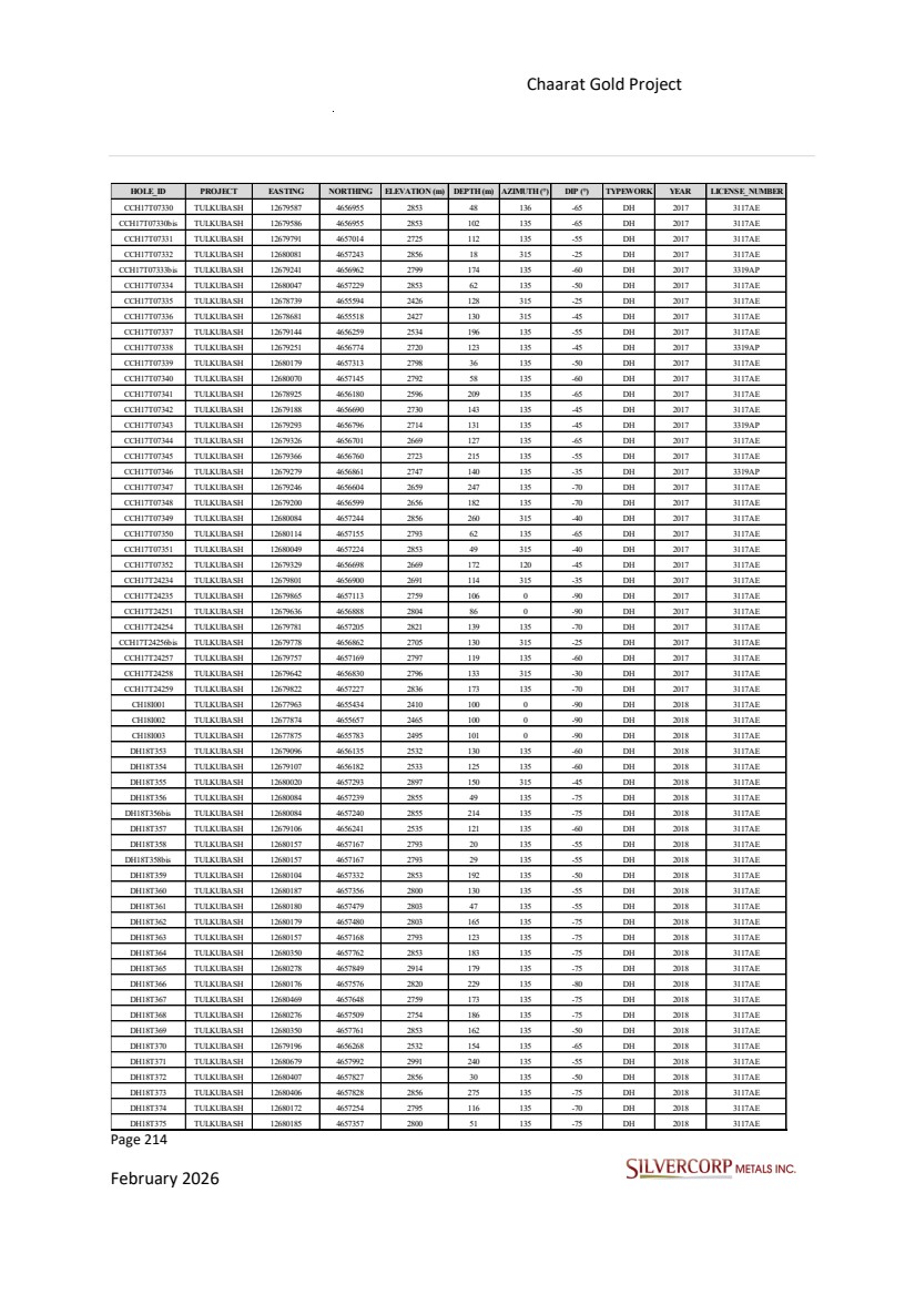
| Page 215 February 2026 Chaarat Gold Project Chatkal district, Kyrgyzstan NI 43-101 Technical Report Mineral Resource Update HOLE_ID PROJECT EASTING NORTHING ELEVATION (m) DEPTH (m) AZIMUTH (°) DIP (°) TYPEWORK YEAR LICENSE_NUMBER DH18T375bis TULKUBASH 12680186 4657356 2800 152 135 -75 DH 2018 3117AE DH18T376 TULKUBASH 12678961 4655894 2450 147 135 -50 DH 2018 3117AE DH18T377 TULKUBASH 12680177 4657576 2820 160 135 -50 DH 2018 3117AE DH18T378 TULKUBASH 12680272 4657737 2845 144 135 -75 DH 2018 3117AE DH18T379 TULKUBASH 12680388 4657806 2854 230 135 -55 DH 2018 3117AE DH18T380 TULKUBASH 12680207 4657683 2834 178 135 -60 DH 2018 3117AE DH18T381 TULKUBASH 12678758 4655737 2483 163 135 -60 DH 2018 3117AE DH18T382 TULKUBASH 12680813 4657868 2860 120 135 -65 DH 2018 3117AE DH18T383 TULKUBASH 12680416 4657587 2759 162 135 -55 DH 2018 3117AE DH18T384 TULKUBASH 12680374 4657970 2942 301 135 -50 DH 2018 3117AE DH18T385 TULKUBASH 12680541 4657826 2859 285 135 -50 DH 2018 3117AE DH18T386 TULKUBASH 12680316 4657575 2757 166 135 -65 DH 2018 3117AE DH18T387 TULKUBASH 12680180 4657480 2803 144 135 -60 DH 2018 3117AE DH18T388 TULKUBASH 12678821 4655788 2476 220 135 -65 DH 2018 3117AE DH18T389 TULKUBASH 12680688 4657778 2858 165 135 -55 DH 2018 3117AE DH18T390 TULKUBASH 12680104 4657332 2853 147 135 -50 DH 2018 3117AE DH18T391 TULKUBASH 12681216 4658433 3012 277 135 -70 DH 2018 3117AE DH18T392 TULKUBASH 12681040 4658322 2995 150 135 -65 DH 2018 3117AE DH18T393 TULKUBASH 12680439 4658029 2953 345 135 -70 DH 2018 3117AE DH18T394 TULKUBASH 12680207 4657682 2834 201 135 -75 DH 2018 3117AE DH18T395 TULKUBASH 12680270 4657737 2846 176 135 -80 DH 2018 3117AE DH18T396 TULKUBASH 12680075 4657585 2863 158 135 -50 DH 2018 3117AE DH18T397 TULKUBASH 12681150 4658209 2907 222 135 -65 DH 2018 3117AE DH18T398 TULKUBASH 12680272 4657505 2753 146 135 -55 DH 2018 3117AE DH18T399 TULKUBASH 12680687 4657780 2858 209 135 -75 DH 2018 3117AE DH18T400 TULKUBASH 12680084 4657239 2855 83 135 -75 DH 2018 3117AE DH18T401 TULKUBASH 12680543 4657826 2859 309 135 -75 DH 2018 3117AE DH18T402 TULKUBASH 12680559 4658009 2969 231 135 -50 DH 2018 3117AE DH18T403 TULKUBASH 12680766 4657803 2864 123 315 -35 DH 2018 3117AE DH18T404 TULKUBASH 12678725 4655670 2484 202 135 -55 DH 2018 3117AE DH18T405 TULKUBASH 12680887 4657915 2866 165 135 -70 DH 2018 3117AE DH18T406 TULKUBASH 12680568 4657669 2764 156 135 -55 DH 2018 3117AE DH18T407 TULKUBASH 12680090 4657457 2843 156 135 -55 DH 2018 3117AE DH18T408 TULKUBASH 12680715 4658042 2999 240 135 -60 DH 2018 3117AE DH18T409 TULKUBASH 12680256 4657405 2751 90 135 -55 DH 2018 3117AE DH18T410 TULKUBASH 12678913 4655923 2487 213 135 -55 DH 2018 3117AE DH18T411 TULKUBASH 12680315 4657574 2757 215 135 -80 DH 2018 3117AE DH18T412 TULKUBASH 12680682 4657785 2859 88 315 -25 DH 2018 3117AE DH18T413 TULKUBASH 12680073 4657585 2863 231 135 -75 DH 2018 3117AE DH18T414 TULKUBASH 12680021 4657296 2896 216 135 -65 DH 2018 3117AE DH18T415 TULKUBASH 12680557 4658011 2969 315 135 -70 DH 2018 3117AE DH18T416 TULKUBASH 12680279 4657848 2914 135 135 -50 DH 2018 3117AE DH18T417 TULKUBASH 12680242 4657309 2750 123 135 -80 DH 2018 3117AE DH18T418 TULKUBASH 12680682 4657785 2860 185 315 -35 DH 2018 3117AE DH18T419 TULKUBASH 12680948 4658389 3076 220 135 -65 DH 2018 3117AE DH18T420 TULKUBASH 12678683 4655654 2488 170 135 -55 DH 2018 3117AE DH18T421 TULKUBASH 12680809 4658152 3041 268 135 -60 DH 2018 3117AE DH18T422 TULKUBASH 12680582 4657809 2860 281 135 -50 DH 2018 3117AE DH18T423 TULKUBASH 12678750 4656028 2612 200 135 -70 DH 2018 3117AE DH18T424 TULKUBASH 12680410 4657590 2759 187 315 -25 DH 2018 3117AE DH18T425 TULKUBASH 12680079 4657696 2883 164 135 -60 DH 2018 3117AE DH18T426 TULKUBASH 12680982 4657982 2876 144 135 -60 DH 2018 3117AE DH18T427 TULKUBASH 12680002 4657428 2912 205 135 -75 DH 2018 3117AE DH18T428 TULKUBASH 12680376 4657972 2942 77 135 -75 DH 2018 3117AE DH18T428bis TULKUBASH 12680380 4657976 2943 300 135 -75 DH 2018 3117AE DH18T429 TULKUBASH 12680715 4658043 2999 263 135 -75 DH 2018 3117AE DH18T430 TULKUBASH 12678685 4655955 2624 226 135 -60 DH 2018 3117AE DH18T431 TULKUBASH 12681081 4658061 2897 145 135 -65 DH 2018 3117AE DH18T432 TULKUBASH 12680327 4657908 2929 163 135 -55 DH 2018 3117AE |
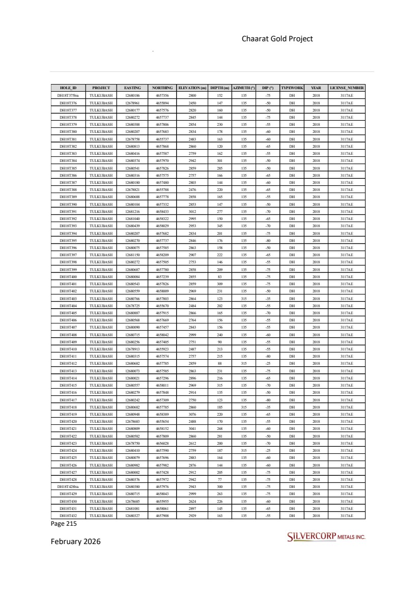
| Page 216 February 2026 Chaarat Gold Project Chatkal district, Kyrgyzstan NI 43-101 Technical Report Mineral Resource Update HOLE_ID PROJECT EASTING NORTHING ELEVATION (m) DEPTH (m) AZIMUTH (°) DIP (°) TYPEWORK YEAR LICENSE_NUMBER DH18T433 TULKUBASH 12680815 4657871 2860 58 135 -80 DH 2018 3117AE DH18T433bis TULKUBASH 12680813 4657867 2860 150 135 -90 DH 2018 3117AE DH18T434 TULKUBASH 12680856 4658230 3063 148 135 -55 DH 2018 3117AE DH18T435 TULKUBASH 12680883 4657921 2867 125 315 -30 DH 2018 3117AE DH18T436 TULKUBASH 12678617 4655928 2633 165 135 -55 DH 2018 3117AE DH18T437 TULKUBASH 12680440 4658031 2953 285 135 -50 DH 2018 3117AE DH18T438 TULKUBASH 12680419 4657589 2759 163 135 -75 DH 2018 3117AE DH18T439 TULKUBASH 12680677 4657992 2991 260 135 -75 DH 2018 3117AE DH18T440 TULKUBASH 12680711 4658047 3000 185 315 -30 DH 2018 3117AE DH18T441 TULKUBASH 12678567 4655870 2643 195 135 -55 DH 2018 3117AE DH18T442 TULKUBASH 12681331 4658324 2932 188 135 -70 DH 2018 3117AE DH18T443 TULKUBASH 12680983 4657984 2877 176 135 -75 DH 2018 3117AE DH18T444 TULKUBASH 12680919 4658267 3074 94 135 -55 DH 2018 3117AE DH18T445 TULKUBASH 12680566 4657671 2764 117 135 -75 DH 2018 3117AE DH18T446 TULKUBASH 12680975 4658161 2995 160 135 -55 DH 2018 3117AE DH18T447 TULKUBASH 12680809 4658153 3041 113 135 -75 DH 2018-2019 3117AE DH18T448 TULKUBASH 12678519 4655803 2653 191 135 -55 DH 2018 3117AE DH18T449 TULKUBASH 12681108 4658379 3002 33 135 -55 DH 2018 3117AE DH18T450 TULKUBASH 12680220 4657204 2750 31 135 -65 DH 2018 3117AE DH18T450bis TULKUBASH 12680219 4657206 2750 65 135 -65 DH 2018 3117AE DH18T451 TULKUBASH 12681214 4658711 3140 10 135 -65 DH 2018 3117AE DH18T452 TULKUBASH 12680978 4657990 2878 132 315 -30 DH 2018 3117AE DH18T453 TULKUBASH 12678456 4655819 2654 149 135 -60 DH 2018 3117AE DH18T454 TULKUBASH 12680257 4657408 2750 129 135 -75 DH 2018 3117AE DH18T455 TULKUBASH 12678645 4655608 2489 195 135 -55 DH 2018 3117AE DH18T456 TULKUBASH 12680469 4657648 2759 45 135 -50 DH 2018 3117AE DH18T457 TULKUBASH 12680677 4657653 2768 115 135 -60 DH 2018 3117AE DH18T457bis TULKUBASH 12680676 4657654 2768 183 135 -60 DH 2018 3117AE DH18T458 TULKUBASH 12680469 4657648 2759 33 135 -55 DH 2018 3117AE DH18T459 TULKUBASH 12681267 4658319 2927 210 135 -50 DH 2018 3117AE DH18T460 TULKUBASH 12678681 4655959 2625 242 315 -30 DH 2018 3117AE DH18T461 TULKUBASH 12678996 4655956 2450 171 135 -55 DH 2018 3117AE DH18T462 TULKUBASH 12680312 4657752 2850 180 135 -50 DH 2018 3117AE DH18T463 TULKUBASH 12679067 4655980 2449 132 135 -60 DH 2018 3117AE DH18T464 TULKUBASH 12680443 4657610 2759 82 135 -55 DH 2018 3117AE DH19T465 TULKUBASH 12678452 4655822 2655 170 315 -30 DH 2019 3117AE DH19T466 TULKUBASH 12678563 4655875 2644 200 315 -30 DH 2019 3117AE DH19T467 TULKUBASH 12678745 4656031 2613 254 315 -30 DH 2019 3117AE DH19T468 TULKUBASH 12678613 4655933 2634 204 315 -30 DH 2019 3117AE DH19T469 TULKUBASH 12680810 4658161 3043 189 315 -30 DH 2019 3117AE DH19T470 TULKUBASH 12680726 4658123 3027 130 135 -45 DH 2019 3117AE DH19T471 TULKUBASH 12681277 4658761 3135 69 135 -45 DH 2019 3117AE DH19T472 TULKUBASH 12680720 4658129 3028 102 315 -25 DH 2019 3117AE DH19T473 TULKUBASH 12678617 4655928 2633 180 135 -60 DH 2019 3117AE DH19T474 TULKUBASH 12681177 4658623 3147 180 135 -45 DH 2019 3117AE DH19T475 TULKUBASH 12681210 4658705 3139 217 135 -45 DH 2019 3117AE DH19T476 TULKUBASH 12680358 4657598 2760 177 135 -45 DH 2019 3117AE DH19T477 TULKUBASH 12680285 4657547 2755 220 135 -45 DH 2019 3117AE DH19T478 TULKUBASH 12680901 4658233 3059 70 135 -45 DH 2019 3117AE DH19T479 TULKUBASH 12680887 4658354 3089 131 315 -25 DH 2019 3117AE DH19T480 TULKUBASH 12680848 4658229 3064 133 315 -25 DH 2019 3117AE DH19T481 TULKUBASH 12680900 4658234 3059 206 135 -60 DH 2019 3117AE DH19T482 TULKUBASH 12681277 4658761 3135 76 135 -60 DH 2019 3117AE DH19T482bis TULKUBASH 12681280 4658762 3135 74 145 -60 DH 2019 3117AE DH19T483 TULKUBASH 12681515 4658862 3031 30 135 -45 DH 2019 3117AE DH19T484 TULKUBASH 12680976 4658498 3107 255 135 -60 DH 2019 3117AE DH19T485 TULKUBASH 12681118 4658582 3137 250 135 -45 DH 2019 3117AE DH19T486 TULKUBASH 12681453 4658914 3058 12 135 -45 DH 2019 3117AE DH19T487 TULKUBASH 12681284 4658401 2991 161 135 -45 DH 2019 3117AE |
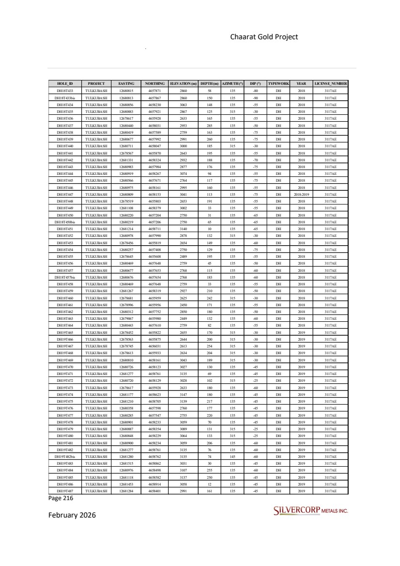
| Page 217 February 2026 Chaarat Gold Project Chatkal district, Kyrgyzstan NI 43-101 Technical Report Mineral Resource Update HOLE_ID PROJECT EASTING NORTHING ELEVATION (m) DEPTH (m) AZIMUTH (°) DIP (°) TYPEWORK YEAR LICENSE_NUMBER DH19T488 TULKUBASH 12681333 4658324 2932 220 135 -55 DH 2019 3117AE DH19T489 TULKUBASH 12680315 4657571 2757 55 135 -45 DH 2019 3117AE DH19T490 TULKUBASH 12681224 4658812 3120 71 135 -45 DH 2019 3117AE DH19T491 TULKUBASH 12681151 4658768 3113 160 135 -45 DH 2019 3117AE DH19T492 TULKUBASH 12681405 4658849 3100 270 135 -45 DH 2019 3117AE DH19T493 TULKUBASH 12680107 4657766 2894 83 135 -50 DH 2019 3117AE DH19T493bis TULKUBASH 12680109 4657767 2894 125 135 -50 DH 2019 3117AE DH19T494 TULKUBASH 12681255 4658448 3020 197 135 -60 DH 2019 3117AE DH19T495 TULKUBASH 12681182 4658296 2923 225 135 -45 DH 2019 3117AE DH19T496 TULKUBASH 12681223 4658813 3120 230 135 -60 DH 2019 3117AE DH19T497 TULKUBASH 12681152 4658209 2907 125 135 -45 DH 2019 3117AE DH19T498 TULKUBASH 12680201 4657840 2905 155 135 -50 DH 2019 3117AE DH19T499 TULKUBASH 12679205 4656919 2800 150 170 -50 DH 2019 3117AE DH19T500 TULKUBASH 12679333 4656919 2795 90 180 -50 DH 2019 3117AE DH19T500bis TULKUBASH 12679333 4656920 2795 148 180 -50 DH 2019 3117AE DH19T501 TULKUBASH 12681330 4658825 3130 44 135 -45 DH 2019 3117AE DH19T502 TULKUBASH 12681355 4658906 3089 27 135 -45 DH 2019 3117AE DH19T503 TULKUBASH 12681177 4658625 3146 224 135 -60 DH 2019 3117AE DH19T504 TULKUBASH 12681355 4658906 3089 165 135 -45 DH 2019 3117AE DH19T505 TULKUBASH 12681328 4658827 3130 70 135 -60 DH 2019 3117AE DH19T506 TULKUBASH 12680890 4658369 3087 230 135 -60 DH 2019 3117AE DH19T507 TULKUBASH 12680976 4658496 3107 232 135 -45 DH 2019 3117AE DH19T508 TULKUBASH 12681280 4658535 3036 110 135 -60 DH 2019 3117AE DH19T509 TULKUBASH 12681063 4658531 3122 241 135 -60 DH 2019 3117AE DH19T510 TULKUBASH 12681124 4658585 3138 228 135 -60 DH 2019 3117AE DH19T511 TULKUBASH 12680899 4658233 3058 175 135 -75 DH 2019 3117AE DH19T512 TULKUBASH 12680962 4658402 3076 170 135 -50 DH 2019 3117AE DH19T513 TULKUBASH 12681341 4658483 2981 202 135 -60 DH 2019 3117AE DH19T514 TULKUBASH 12680891 4658367 3087 198 135 -45 DH 2019 3117AE DH19T515 TULKUBASH 12681064 4658530 3122 239 135 -45 DH 2019 3117AE DH19T516 TULKUBASH 12680726 4658125 3027 168 135 -60 DH 2019 3117AE DH19T517 TULKUBASH 12681178 4658417 3006 50 135 -45 DH 2019 3117AE DH19T518 TULKUBASH 12680854 4658226 3063 151 135 -60 DH 2019 3117AE DH19T519 TULKUBASH 12681259 4658909 3078 44 70 -50 DH 2019 3117AE DH19T520 TULKUBASH 12681035 4658317 2995 161 135 -45 DH 2019 3117AE DH19T521 TULKUBASH 12681516 4658861 3030 32 135 -45 DH 2019 3117AE DH19T521bis TULKUBASH 12681516 4658861 3030 65 135 -60 DH 2019 3117AE DH19T522 TULKUBASH 12681453 4658914 3058 72 135 -45 DH 2019 3117AE DH19T523 TULKUBASH 12681363 4658789 3109 252 135 -55 DH 2019 3117AE DH19T524 TULKUBASH 12681262 4658906 3079 173 70 -75 DH 2019 3117AE DH19T525 TULKUBASH 12681562 4659190 2943 177 135 -60 DH 2019 3117AE DH19T526 TULKUBASH 12681259 4658906 3078 42 70 -60 DH 2019 3117AE DH19T527 TULKUBASH 12681591 4659132 2952 150 135 -50 DH 2019 3117AE DH19T528 TULKUBASH 12681452 4658914 3057 155 135 -60 DH 2019 3117AE DH19T529 TULKUBASH 12681512 4658858 3029 169 135 -75 DH 2019 3117AE DH19T530 TULKUBASH 12681106 4658378 3002 166 135 -60 DH 2019 3117AE DH19T532 TULKUBASH 12681401 4659087 2973 13 135 -45 DH 2019 3117AE DH19T533 TULKUBASH 12681359 4658793 3109 159 315 -45 DH 2019 3117AE DH19T534 TULKUBASH 12681545 4659061 2961 207 135 -45 DH 2019 3117AE |
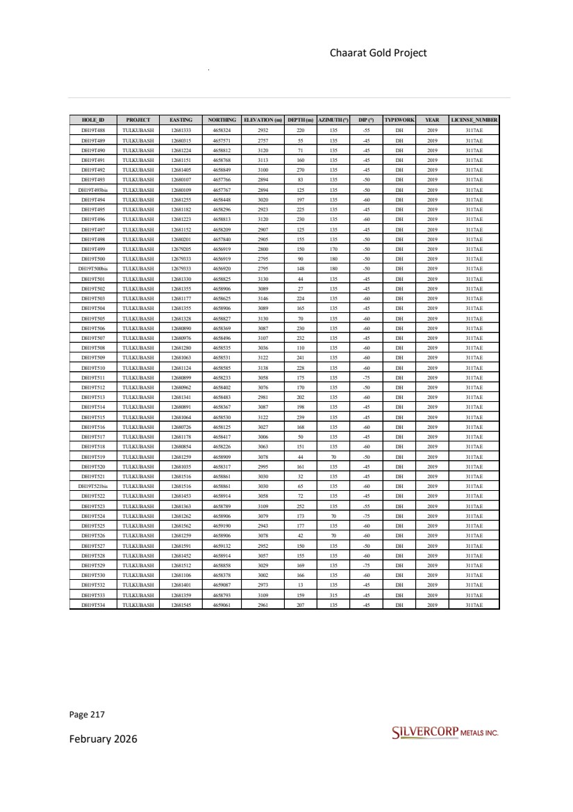
| Page 218 February 2026 Chaarat Gold Project Chatkal district, Kyrgyzstan NI 43-101 Technical Report Mineral Resource Update HOLE_ID PROJECT EASTING NORTHING ELEVATION (m) DEPTH (m) AZIMUTH (°) DIP (°) TYPEWORK YEAR LICENSE_NUMBER DH19T535 TULKUBASH 12681457 4659143 2960 203 135 -45 DH 2019 3117AE DH19T536 TULKUBASH 12681463 4659029 3010 170 135 -45 DH 2019 3117AE DH19T537 TULKUBASH 12681510 4658866 3031 144 315 -35 DH 2019 3117AE DH19T538 TULKUBASH 12681593 4659132 2952 18 135 -45 DH 2019 3117AE DH19T540 TULKUBASH 12681395 4659088 2973 215 135 -50 DH 2019 3117AE DH19T541 TULKUBASH 12681218 4659018 3004 231 135 -50 DH 2019 3117AE DH19T542 TULKUBASH 12681587 4658901 2983 132 135 -45 DH 2019 3117AE DH19T543 TULKUBASH 12681586 4659137 2952 171 315 -35 DH 2019 3117AE DH19T544 TULKUBASH 12681288 4659158 2917 100 92 -45 DH 2019 3117AE DH19T545 TULKUBASH 12681446 4658919 3058 80 315 -35 DH 2019 3117AE DH19T547 TULKUBASH 12681621 4659203 2904 140 135 -45 DH 2019 3117AE DH19T548 TULKUBASH 12681674 4659167 2905 173 135 -65 DH 2019 3117AE DH19T549 TULKUBASH 12681324 4659061 2987 144 135 -45 DH 2019 3117AE DH19T550 TULKUBASH 12681557 4659271 2889 114 135 -40 DH 2019 3117AE DH19T551 TULKUBASH 12681539 4659068 2961 163 315 -35 DH 2019 3117AE DH19T552 TULKUBASH 12681634 4659266 2877 250 135 -45 DH 2019 3117AE DH19T553 TULKUBASH 12681626 4659061 2906 277 135 -45 DH 2019 3117AE DH19T554 TULKUBASH 12681671 4658914 2920 317 135 -45 DH 2019 3117AE DH19T555 TULKUBASH 12681554 4659273 2889 103 315 -45 DH 2019 3117AE DH19T556 TULKUBASH 12681421 4659504 2730 182 135 -50 DH 2019 3117AE DH19T557 TULKUBASH 12681678 4659351 2801 185 135 -45 DH 2019 3117AE DH19T558 TULKUBASH 12681576 4659362 2816 92 135 -45 DH 2019 3117AE DH19T560 TULKUBASH 12681716 4659551 2676 250 135 -45 DH 2019 3117AE DH19T561 TULKUBASH 12681674 4659355 2801 153 315 -45 DH 2019 3117AE DH19T562 TULKUBASH 12681363 4658790 3109 202 135 -75 DH 2019 3117AE DH19T563 TULKUBASH 12681462 4659029 3010 171 135 -60 DH 2019 3117AE DH19T564 TULKUBASH 12681451 4658914 3058 218 135 -75 DH 2019 3117AE DH19T565 TULKUBASH 12681496 4659217 2915 180 135 -50 DH 2019 3117AE DH19T566 TULKUBASH 12681884 4659507 2645 170 135 -45 DH 2019 3117AE DH19T567 TULKUBASH 12681177 4658625 3147 54 315 -35 DH 2019 3117AE DH19T567bis TULKUBASH 12681171 4658628 3147 137 315 -35 DH 2019 3117AE DH19T568 TULKUBASH 12681514 4658857 3031 130 135 -65 DH 2019 3117AE DH19T569 TULKUBASH 12681459 4659032 3010 93 315 -50 DH 2019 3117AE DH19T570 TULKUBASH 12681839 4659440 2699 274 135 -45 DH 2019 3117AE DH19T571 TULKUBASH 12681879 4659511 2645 261 315 -40 DH 2019 3117AE DH19T572 TULKUBASH 12681660 4658828 2933 174 135 -45 DH 2019 3117AE DH19T573 TULKUBASH 12681405 4658849 3100 35 135 -60 DH 2019 3117AE DH19T573bis TULKUBASH 12681408 4658857 3099 219 135 -65 DH 2019 3117AE DH19T574 TULKUBASH 12681543 4659061 2961 113 135 -60 DH 2019 3117AE DH19T575 TULKUBASH 12681588 4658903 2983 142 135 -65 DH 2019 3117AE DH19T576 TULKUBASH 12681279 4658401 2991 101 315 -45 DH 2019 3117AE DH19T577 TULKUBASH 12680852 4658172 3048 98 135 -60 DH 2019 3117AE DH19T578 TULKUBASH 12681795 4660116 2869 159 135 -45 DH 2019 3117AE DH19T579 TULKUBASH 12681396 4659088 2973 230 135 -60 DH 2019 3117AE DH19T580 TULKUBASH 12681167 4659245 2888 171 135 -45 DH 2019 3117AE DH19T581 TULKUBASH 12681352 4659157 2923 168 270 -50 DH 2019 3117AE DH19T582 TULKUBASH 12681281 4659313 2822 138 135 -50 DH 2019 3117AE DH19T583 TULKUBASH 12681803 4660255 2819 177 135 -45 DH 2019 3117AE |

| Page 219 February 2026 Chaarat Gold Project Chatkal district, Kyrgyzstan NI 43-101 Technical Report Mineral Resource Update HOLE_ID PROJECT EASTING NORTHING ELEVATION (m) DEPTH (m) AZIMUTH (°) DIP (°) TYPEWORK YEAR LICENSE_NUMBER DH19T584 TULKUBASH 12681352 4659155 2924 178 240 -45 DH 2019 3117AE DH19T585 TULKUBASH 12681458 4659141 2960 153 135 -30 DH 2019 3117AE DH19T586 TULKUBASH 12681507 4659160 2955 150 135 -50 DH 2019 3117AE DH21T587 TULKUBASH 12680050 4657226 2853 135 140 -55 DH 2021 3117AE DH21T588 TULKUBASH 12680084 4657241 2855 163 140 -55 DH 2021 3117AE DH21T589 TULKUBASH 12679982 4657121 2781 80 140 -47 DH 2021 3117AE DH21T590 TULKUBASH 12680458 4657549 2722 81 140 -50 DH 2021 3117AE DH21T591 TULKUBASH 12680481 4657579 2725 80 140 -55 DH 2021 3117AE DH21T592 TULKUBASH 12680602 4657748 2821 140 135 -55 DH 2021 3117AE DH21T593 TULKUBASH 12680894 4658292 3084 175 135 -60 DH 2021 3117AE DH21T594 TULKUBASH 12681103 4658543 3117 150 136 -70 DH 2021 3117AE DH21T595 TULKUBASH 12680948 4658294 3063 110 135 -50 DH 2021 3117AE DH21T597 TULKUBASH 12681105 4658543 3117 72 136 -50 DH 2021 3117AE DH21T599 TULKUBASH 12680739 4658062 2997 91 135 -60 DH 2021 3117AE DH21T600 TULKUBASH 12680706 4658090 3021 150 135 -65 DH 2021 3117AE DH21T602 TULKUBASH 12680771 4658146 3034 150 135 -50 DH 2021 3117AE DH21T606 TULKUBASH 12681281 4658537 3037 100 95 -55 DH 2021 3117AE DH21T609 TULKUBASH 12681179 4658588 3132 81 135 -55 DH 2021 3117AE DH21T610 TULKUBASH 12681182 4658740 3129 85 135 -50 DH 2021 3117AE DH21T611 TULKUBASH 12681146 4658608 3146 150 135 -58 DH 2021 3117AE DH21T612 TULKUBASH 12681226 4658634 3120 85 135 -60 DH 2021 3117AE DH21T613 TULKUBASH 12680097 4657281 2857 130 135 -50 DH 2021 3117AE DH21T614 TULKUBASH 12680042 4657176 2819 120 135 -65 DH 2021 3117AE DH21T616 TULKUBASH 12681190 4658682 3139 160 135 -50 DH 2021 3117AE DH21T617 TULKUBASH 12681151 4658663 3156 85 135 -60 DH 2021 3117AE DH21T618 TULKUBASH 12681231 4658755 3140 60 136 -50 DH 2021 3117AE DH21T619 TULKUBASH 12679996 4657168 2817 127 135 -58 DH 2021 3117AE RC20T001 TULKUBASH 12678691 4655976 2623 125 135 -73 RC 2020 3117AE RC20T002 TULKUBASH 12678664 4655948 2628 90 135 -55 RC 2020 3117AE RC20T003 TULKUBASH 12678664 4655949 2628 120 135 -75 RC 2020 3117AE RC20T004 TULKUBASH 12678620 4655928 2633 150 135 -75 RC 2020 3117AE RC20T005 TULKUBASH 12678599 4655896 2638 80 135 -50 RC 2020 3117AE RC20T006 TULKUBASH 12678598 4655896 2639 90 135 -75 RC 2020 3117AE RC20T007 TULKUBASH 12678541 4655842 2648 80 135 -55 RC 2020 3117AE RC20T008 TULKUBASH 12678542 4655843 2648 130 135 -80 RC 2020 3117AE RC20T009 TULKUBASH 12678530 4655906 2680 162 135 -62 RC 2020 3117AE RC20T010 TULKUBASH 12678627 4656040 2688 105 135 -65 RC 2020 3117AE RC20T011 TULKUBASH 12678641 4656072 2687 90 135 -45 RC 2020 3117AE RC20T012 TULKUBASH 12678642 4656076 2687 115 135 -75 RC 2020 3117AE RC20T013 TULKUBASH 12678580 4656033 2702 140 135 -65 RC 2020 3117AE RC20T014 TULKUBASH 12678578 4656031 2702 110 135 -45 RC 2020 3117AE RC20T015 TULKUBASH 12678516 4655973 2708 110 135 -55 RC 2020 3117AE RC20T016 TULKUBASH 12678519 4655976 2708 140 135 -75 RC 2020 3117AE RC20T017 TULKUBASH 12678584 4655995 2684 80 170 -60 RC 2020 3117AE RC20T018 TULKUBASH 12678466 4655922 2703 115 135 -75 RC 2020 3117AE RC20T019 TULKUBASH 12678466 4655979 2730 150 135 -70 RC 2020 3117AE RC20T020 TULKUBASH 12678463 4655978 2730 102 135 -45 RC 2020 3117AE RC20T021 TULKUBASH 12678639 4656156 2690 150 135 -60 RC 2020 3117AE MD21C001 KYZYLTASH 12682128 4659006 2606 305 310 -70 MET_HOLE 2021 3117AE MD21C002 KYZYLTASH 12682173 4659079 2581 365 310 -70 MET_HOLE 2021 3117AE MD21C003 KYZYLTASH 12681645 4658524 2819 345 320 -75 MET_HOLE 2021 3117AE MD21C004 KYZYLTASH 12681421 4658069 2762 263 310 -35 MET_HOLE 2021 3117AE MD21C005 KYZYLTASH 12681757 4658675 2834 206 135 -60 MET_HOLE 2021 3117AE MD21M001 KYZYLTASH 12682505 4658351 2256 201 283 -45 MET_HOLE 2021 3117AE MD21M007 KYZYLTASH 12682134 4657913 2340 151 136 -70 MET_HOLE 2021 3117AE MD21M008 KYZYLTASH 12679888 4656417 2491 130 316 -75 MET_HOLE 2021 3117AE MD21M009 KYZYLTASH 12681768 4657689 2437 242 315 -60 MET_HOLE 2021 3117AE MD21M010 KYZYLTASH 12680442 4656940 2550 136 0 -90 MET_HOLE 2021 3117AE MD21M011 KYZYLTASH 12680470 4656867 2502 81 315 -30 MET_HOLE 2021 3117AE MD21M012 KYZYLTASH 12681194 4657351 2447 252 316 -35 MET_HOLE 2021 3117AE MD21M013 KYZYLTASH 12680873 4657130 2445 129 135 -60 MET_HOLE 2021 3117AE MD21M014 KYZYLTASH 12681031 4657261 2486 162 135 -60 MET_HOLE 2021 3117AE MD21M015 KYZYLTASH 12680436 4656755 2470 342 335 -45 MET_HOLE 2021 3117AE MD21M016 KYZYLTASH 12681116 4657133 2364 200 315 -40 MET_HOLE 2021 3117AE |