TECHNICAL REPORT SUMMARY
ABM LISBON VALLEY LITHIUM PROJECT
SAN JUAN COUNTY,
UTAH, USA
Effective Date: May 15, 2023
Prepared for:
American Battery Materials, Inc.
By:
Bradley C. Peek, MSc., CPG
Peek Consulting, Inc.
V.05.2023.03
| American Battery Materials, Inc. Technical Report Summary | Lisbon Valley Lithium San Juan County, Utah |
TABLE OF CONTENTS
| 1. | SUMMARY | 1 |
| 1.1 | Introduction | 1 |
| 1.2 | Property Description and Location | 1 |
| 1.3 | Accessibility, Climate, Local Resources, Infrastructure and Physiography | 2 |
| 1.4 | History | 2 |
| 1.5 | Geologic Setting and Mineralization | 3 |
| 1.6 | Deposit Types | 4 |
| 1.7 | Exploration | 5 |
| 1.8 | Drilling | 6 |
| 1.9 | Mineral Processing and Metallurgical Testing | 6 |
| 1.10 | Adjacent Properties | 6 |
| 1.11 | Interpretation and Conclusions | 7 |
| 1.12 | Recommendations | 7 |
| 2. | INTRODUCTION | 8 |
| 3. | RELIANCE ON OTHER SPECIALISTS | 9 |
| 4. | PROPERTY DESCRIPTION AND LOCATION | 9 |
| 5. | ACCESSIBILITY, CLIMATE, LOCAL RESOURCES, INFRASTRUCTURE AND PHYSIOGRAPHY | 14 |
| 6. | HISTORY | 17 |
| 7. | GEOLOGIC SETTING AND MINERALIZATION | 20 |
| 7.1 | Stratigraphy | 21 |
| 7.2 | Geophysics | 25 |
Page i Lisbon Valley Lithium Project | Prepared for |  |
| American Battery Materials, Inc. Technical Report Summary | Lisbon Valley Lithium San Juan County, Utah |
| 8. | DEPOSIT TYPES | 26 |
| 8.1 | Brines | 27 |
| 8.2 | Wells Located on the Subject Property | 37 |
| 9. | EXPLORATION | 39 |
| 10. | DRILLING | 40 |
| 11. | SAMPLE PREPARATION, ANALYSES AND SECURITY | 40 |
| 12. | DATA VERIFICATION | 40 |
| 13. | MINERAL PROCESSING AND METALLURGICAL TESTING | 40 |
| 14. | ADJACENT PROPERTIES | 42 |
| 15. | OTHER RELEVANT DATA AND INFORMATION | 44 |
| 16. | INTERPRETATION AND CONCLUSIONS | 44 |
| 17. | RECOMMENDATIONS | 44 |
| 18. | REFERENCES | 45 |
| 19. | CERTIFICATE OF THE AUTHOR | 48 |
| 20. | CONSENT OF COMPETENT PERSON | 49 |
Page ii Lisbon Valley Lithium Project | Prepared for | |
| American Battery Materials, Inc. Technical Report Summary | Lisbon Valley Lithium San Juan County, Utah |
List of Figures
| Figure 4.1 – Road map of Utah with project location. | 10 |
| Figure 4.2 – Overview of ABM’s Lisbon Lithium claims in San Juan County, Utah. | 12 |
| Figure 4.3 – An example of one of the claim stakes found on the property May 7, 2023. | 13 |
| Figure 5.1 – Topographic map underlying the outline of the ABM claim block. CI=40’ | 15 |
| Figure 5.2 – Climate data for Moab, Utah. | 16 |
| Figure 6.1 – Lisbon Valley Lithium claims in relation to the Superior Peterson Fed 88-21P well. | 19 |
| Figure 7.1 – Structural elements of the Paradox Basin and adjacent areas (from Nuccio and Condon, 1996) | 20 |
| Figure 7.2 – Generalized stratigraphic nomenclature within the greater Paradox Basin area. | 22 |
| Figure 7.3 – Geologic map of the LVL claim area outlined in red. Modified after Doelling (2002). The Lisbon Valley Fault trend in shown in the block dotted line in NE quadrant of the map below | 23 |
| Figure 7.4 – W-E Cross section through the Lisbon Oil field on the north flank of the Lisbon Valley Anticline | 24 |
| Figure 7.5a – Three-dimensional analysis of the Lisbon Valley gravity anomaly (Byerly and Joesting, 1959) | 25 |
| Figure 7.5b – Two-dimensional analysis of the Lisbon Valley gravity anomaly (Byerly and Joesting, 1959) | 26 |
| Figure 8.1 – Oil and gas wells occurring on the ABM claims | 38 |
| Figure 9.1 – Stratigraphic column and type log for the units showing (Pennsylvanian) clastic and salt section (Mayhew and Heylmann 1965) | 39 |
| Figure 13.1 – Process flow diagram of a typical lithium extraction process | 41 |
| Figure 14.1 – The location of ABM’s Lisbon Lithium Project relative to Anson’s project and the Cane Creek Potash Mine. | 43 |
Page iii Lisbon Valley Lithium Project | Prepared for | |
| American Battery Materials, Inc. Technical Report Summary | Lisbon Valley Lithium San Juan County, Utah |
List of Tables
| Table 1.1 - Chemical analysis of brine from the Superior Fed 88-21P well from Hite (1978). | 3 |
| Table 1.2 - Anson Resources announced resources from their DFS | 7 |
| Table 2.1 - Abbreviations and Acronyms used in report | 9 |
| Table 4.1 - Claims with BLM UT numbers | 11 |
| Table 6.1 - Chemical analysis of brine from the Superior Fed 88-21P well from Hite (1978) | 18 |
| Table 8.1 - Amerada Petroleum No. 2 Green River | 28 |
| Table 8.2 - British-American No. 1 Gov’t.-Norwood | 28 |
| Table 8.3 - California Oil No. 1, Navajo 177 | 29 |
| Table 8.4 - Delhi-Taylor No. 2, Seven Mile | 29 |
| Table 8.5 - Humble No. 1 Rustler Dome | 30 |
| Table 8.6 - King Oil No. 2 Big Flat | 30 |
| Table 8.7 - Pure Oil No. 1 Hobson-USA | 30 |
| Table 8.8 - Pure Oil No. 1 Hobson-USA | 31 |
| Table 8.9 - Pure Oil No. 2 Big Flat | 31 |
| Table 8.10 - Roberts Brine Well | 32 |
| Table 8.11 - Southern Natural No. 1 Long Canyon | 32 |
| Table 8.12 - Southern Natural No. 1 Long Canyon | 33 |
| Table 8.13 - Suburban Storage No. 1 | 33 |
| Table 8.14 - Superior No. 22-34 Salt Wash | 34 |
| Table 8.15 - Superior No. 14-5 Bowknot | 34 |
| Table 8.16 - Texaco No. 2 Navajo AC | 35 |
| Table 8.17 - Texaco No. 1 Smoot (Salt Wash field) | 35 |
| Table 8.18 - Tidewater No. 74-11 Big Flat | 36 |
| Table 8.19 - Tidewater No. 74-11 Big Flat | 36 |
| Table 8.20 - White Cloud #2 (aka. Roberts Brine Well) | 36 |
| Table 8.21 - Oil & gas wells drilled within the LVL claim block | 37 |
| Table 14.1 - Anson Resources announced resources from their DFS | 42 |
| Table 14.2 - Financial highlights from the Anson Resources DFS | 42 |
Page iv Lisbon Valley Lithium Project | Prepared for | |
| American Battery Materials, Inc. Technical Report Summary | Lisbon Valley Lithium San Juan County, Utah |
| 1. | Summary |
| 1.1 | Introduction |
American Battery Materials, Inc. (ABM)(formerly BoxScore Brands Inc.) acquired the rights to the Lisbon Lithium Project from Plateau Ventures LLC. Peek Consulting was engaged by ABM to write this report to document progress on the property and for funding purposes.
The report has been written to conform to the U. S. Securities and Exchange Commission’s (SEC’s) Subpart 1300 of Regulation S-K for a Technical Report Summary. The subject property is an exploration stage property that currently has no mineral resources or mineral reserves yet defined. No exploration has been conducted on the property to date. This report is a summary of the data reviewed and the conclusions drawn from that data.
| 1.2 | Property Description and Location |
The property is located in San Juan County, Utah. The center of the claims lies approximately 35 miles (58 kilometers) southeast of the city of Moab. The property position consists of 102 placer mining claims staked on U. S. Government land administered by the U. S. Bureau of Land Management (BLM).
The claims are in one contiguous group named the LVL group. They were staked in portions of Sections 17-18, 20-22, and 27-29, T30S, R25E, Salt Lake Baseline and Principal Meridian. The claims were originally staked by Plateau Ventures LLC. And sold to Boxscore Brands who changed its corporate name to American Battery Materials, Inc.. All 102 claims are currently owned 100% by Boxscore Brands and will be transferred to American Battery Materials, Inc. in the fall of 2023 when the next annual payment is due.
It will be necessary for ABM to re-enter an oil and gas well or to drill a new well to obtain brine samples for analysis and metallurgical testing. Permits for such operations will be required from the BLM and the Utah Division of Oil, Gas and Mining. These permits are currently in process.
Page 1 Lisbon Valley Lithium Project | Prepared for | |
| American Battery Materials, Inc. Technical Report Summary | Lisbon Valley Lithium San Juan County, Utah |
| 1.3 | Accessibility, Climate, Local Resources, Infrastructure and Physiography |
Moab, Utah, the nearest population center to the property, is a city of 5,336 persons (2020 Census). It is located in a relatively remote portion of Utah but is easily accessed by U. S. Highway 191. Highway 191 intersects with Interstate 70 about 30 miles (48 kilometers) north of Moab, at Crescent Junction. Moab is a tourist destination and has numerous motels and restaurants. Moab would also be the nearest source of labor in the region.
The region has a history of mining, primarily uranium and vanadium that dates back as far as 1881. The Lisbon Valley Copper Mine is in the heart of the Lisbon Valley and is currently producing copper cathode. An all-weather road and electric power supply the mine.
All the ABM claims fall between elevations of 6200 and 6900 feet (1890 and 2100 meters) above sea level.
It is anticipated that ABM will use a Direct Lithium Extraction (DLE) method rather than using evaporation ponds to recover the lithium and other potential mineral from brines, should the project advance to the production stage. The project should therefore have sufficient space on the ABM claims to construct processing facilities.
The climate is arid, also termed “high desert”. Moab has average annual precipitation of 9.02 inches (229 mm). The climatic conditions allow for fieldwork to continue throughout the year.
| 1.4 | History |
The Paradox Basin initially attracted attention because of high lithium values reported in the literature in brines recovered from oil and gas exploration wells. The Paradox Basin has been explored for oil and gas for many years (Durgin, 2011). The earliest discoveries of potash in the area were made in 1924 in oil and gas wells, but the correlation of the beds and the extent and richness of the deposits were not recognized until the 1950s. The Seven Mile, Salt Wash and White Cloud potash target areas, all west of Moab, were quickly identified. Further exploration led to the development of the Cane Creek potash mine adjacent to the Colorado River.
Brines were commonly encountered in these wells, but none of the wells was of economic significance for brine until in 1962 when the Southern Natural Gas Company drilled a well, Long Canyon Unit #1, which encountered a substantial flow of high- density brine at a depth of 6,013 feet (Durgin, 2011).
Page 2 Lisbon Valley Lithium Project | Prepared for | |
| American Battery Materials, Inc. Technical Report Summary | Lisbon Valley Lithium San Juan County, Utah |
Several companies have reported high lithium values occurring in brines from oil & gas and potash wells drilled into the Paradox Formation. Hite (1978) investigated the potash potential of the Lisbon Valley area in a USGS Open File Report. The analytical report has been the main impetus for the acquisition of the Lisbon Valley Lithium property. In Hite’s report, he published the analytical results of a brine sample from the Superior Oil Co. Well Fed 88-21P. Table 1.1 lists the analytical results from Hite’s report.
Table 1.1 - Chemical analysis of brine from the Superior Fed 88-21P well from Hite (1978).
| Compound/Element | % | ppm | ||||||
| Na2O | 9.24 | 92,400 | ||||||
| K2O | 2.91 | 29,100 | ||||||
| Li2O | 0.073 | 730 | ||||||
| CaO | 1.30 | 13,000 | ||||||
| MgO | 7.44 | 74,400 | ||||||
| CO2 | 0.056 | 560 | ||||||
| SO3 | 0.021 | 210 | ||||||
| B2O3 | 0.84 | 8,400 | ||||||
| P2O5 | 0.0009 | 9 | ||||||
| Cl | 19.44 | 194,400 | ||||||
| Br | 0.32 | 3,200 | ||||||
| I | 0.003 | 30 | ||||||
| 1.5 | Geologic Setting and Mineralization |
The Paradox Basin is an oval-shaped area located in southeastern Utah and southwestern Colorado that may be defined by the maximum extent of salt deposits in the Paradox Formation (formerly) referred to as the Hermosa Formation of Middle Pennsylvanian age (Hite and others, 1984; Nuccio and Condon, 1996). The basin was primarily a Pennsylvanian and Permian feature that accumulated thick deposits of carbonate, halite, and clastic rocks in response to downwarping and uplift along its northeastern basin. The basin was later modified, largely due to the Laramide Orogeny 50 to 70 million years (Ma) ago. Today the basin has been eroded in places by uplift of the Colorado Plateau and downcutting by the Colorado River and its tributaries (Nuccio and Condon, 1996).
Page 3 Lisbon Valley Lithium Project | Prepared for | |
| American Battery Materials, Inc. Technical Report Summary | Lisbon Valley Lithium San Juan County, Utah |
The Paradox Basin is composed of sedimentary rocks that overlie an Early Proterozoic basement of metamorphic gneiss and schist that is locally intruded by granite (Nuccio and Condon, 1996; Tweto,1987). Cambrian through Jurassic sedimentary rocks unconformably overlie the basement rock in much of the basin. Cretaceous rocks are also noted in the southeastern part of the basin.
The Paradox Formation, which is of primary interest to this study, contains dolomite, black shale, anhydrite, halite, and other salts. The lithium-rich brines of the Paradox Basin have all been derived from the Paradox Formation. Halite is the most abundant rock type, occurring in beds tens of feet thick. The black, dolomitic shale is the source rock of some of the oil and gas recovered in the basin. The Paradox was deposited in a series of cycles that represent repeated desiccation and marine flooding of the basin (Hite and Buchner, 1981). The black shales of the Paradox have been used as marker beds to correlate depositional cycles throughout the basin. The cycles have been grouped into larger zones, or “substages” (Barnes and others, 1967), or “production intervals” (Hite and others, 1984).
The primary structure in the area of the ABM claims is the Lisbon Valley anticline. It is bordered on its northeast side by the Lisbon Valley fault. The fault zone can be traced on surface northwest and southeast for a distance of 41 miles (66 km). The fault and anticline are the result of salt tectonics prevalent in the Paradox Basin (Hite, 1978).
| 1.6 | Deposit Types |
There is currently no known production of lithium from the Paradox Basin. The deposit model and exploration target for the Lisbon Lithium Project is very similar to the model defined by Anson Resources in the Paradox Basin to the northwest of ABM’s claim block (See Section 13 – Adjacent Properties). Anson, an Australian company, operating in the U.S. as A1 Lithium Incorporated, has defined a major lithium and bromine resource and has completed a Definitive Feasibility Study. ABM’s target deposit model is similar in all respects to that of Anson’s deposit.
In the Paradox Basin the lithium-rich brines occur in the “saline facies” of the Paradox Member of the Hermosa Formation of Pennsylvanian age and are totally in the subsurface. The “saline facies” of the Paradox Formation is composed of at least 29 evaporite cycles. Many of the cycles are potash-bearing and there is an active potash mine in the basin.
The method of extraction of the lithium from the brines is foreseen to be by Direct Lithium Extraction (DLE) and reinjection of the processed brine back into the subsurface. This method has been gaining favor in the lithium industry over the last several years because it does not involve the use of evaporation ponds. DLE uses a much smaller footprint than evaporation ponds and is therefore more acceptable from an environmental standpoint. As yet, ABM has not done any testing for the possibility of using DLE and will not be able to do any testing until samples of brine are acquired from the target formations.
The brines were not considered important until 1962, when Southern Natural Gas intersected the brine zone and a very substantial flow of brines under tremendous pressure. A second well was drilled 500 feet (152 meters) northeast of the first well and encountered flows estimated to be in excess of 50,000 barrels of brine per day. Many of the wells had analyses showing lithium assays. These are partially enumerated in Section 8.1 – Brines.
Seven oil and gas wells have been drilled on the property now held by ABM according to records of the Utah Division of Oil, Gas and Mining. Unfortunately, no analyses of the brines from these wells have been found in the literature. Six of the wells have been plugged and abandoned. One well is being used as a water disposal well.
Page 4 Lisbon Valley Lithium Project | Prepared for | |
| American Battery Materials, Inc. Technical Report Summary | Lisbon Valley Lithium San Juan County, Utah |
| 1.7 | Exploration |
There has been no exploration conducted on the property by ABM or its predecessors other than the gathering and assimilation of data from all available sources.
A thorough review of 40 historic well files and corresponding well log data was conducted in the fall and winter of 2022-2023. Formation tops were picked in 23 of the available 40 wells that penetrated some or all of the Paradox salts/clastics and/or the Leadville Limestone.
Structure contour maps of the zones have been generated but are currently proprietary. The primary targets include Clastic Zones 17 and 31, as well as the Leadville Limestone. These zones have been shown by historical records and recent production to have free flowing brines with high lithium concentrations – in some cases above 200 ppm Li.
Secondary targets are Clastic Zones 19, 29, 33, and 39. These zones have been recently identified by Anson Resources’ drilling and testing (see Section 13 on Adjacent Properties) to contain supersaturated brines with elevated lithium concentrations.
Though potential targets have been identified, ABM intends to test all clastic zones encountered in future appraisal wells.
Page 5 Lisbon Valley Lithium Project | Prepared for | |
| American Battery Materials, Inc. Technical Report Summary | Lisbon Valley Lithium San Juan County, Utah |
| 1.8 | Drilling |
No drilling has been conducted by ABM or its predecessors. Drilling has been conducted by oil and gas and by potash interests on and in the area surrounding the LVL claims, which has provided much of the information for this report.
| 1.9 | Mineral Processing and Metallurgical Testing |
No metallurgical testing has been conducted by ABM and none can be conducted until brine samples can be collected from wells drilled or re-entered on the subject property. The anticipated type of processing envisioned by ABM for extraction of lithium and possibly other commodities from the brines is summarized here.
The use of open ponds for evaporation and concentration of lithium brines is nominally inexpensive, however, the evaporation process is time consuming, land intensive and wasteful of water. The development of new brine resources from undeveloped lithium brine deposits is likely to meet significant environmental and social barriers to implementation, particularly in the US, and evaporation ponds are not considered environmentally sustainable.
Over the past decade many direct lithium extraction (DLE) technologies have arisen due to intense research and economic drive to separate lithium from other ions in a feed solution. These processes can involve organic and inorganic sorption reagents based on polymers, membranes, manganese, titanium, or aluminum oxides and form the backbone of DLE extraction technologies.
| 1.10 | Adjacent Properties |
There is no known lithium production in the Paradox Basin. The Cane Creek potash mine is located 32 miles (51 kilometers) northwest of the LVL claim group. The mine has been operating since 1965, initially as an underground room and pillar style mine. It was converted to a solution mining operation in 1970.
Anson Resources, an Australian company whose properties are primarily west of Moab, Utah, has been active over the past few years in the Paradox Basin. Anson has re- entered four abandoned oil and gas wells and performed extensive testing of the wells’ brine recovery performance and methods for recovering the lithium and bromine from the brines. According to their website, www.ansonresources.com , they have completed a Definitive Feasibility Study (DFS) on September 8, 2022, and have identified substantial indicated and inferred resources of Lithium Carbonate Equivalent (LCE) and Bromine (Br2) as shown in Table 1.2.
Page 6 Lisbon Valley Lithium Project | Prepared for | |
| American Battery Materials, Inc. Technical Report Summary | Lisbon Valley Lithium San Juan County, Utah |
Table 1.2 - Anson Resources announced resources from their DFS.
| Category | Brine (Mt) | Li (ppm) | Br (ppm) | Contained LCE (‘000t) | Contained Br2 (‘000t) | |||||||||||||||
| Indicated | 530 | 123 | 3,474 | 346 | 1,840 | |||||||||||||||
| Inferred | 1,038 | 125 | 3,308 | 692 | 3,434 | |||||||||||||||
| 1.11 | Interpretation and Conclusions |
There is abundant evidence from oil, gas and potash wells drilled in the Paradox Basin that indicates that there is a high probability of identifying and producing super saturated brines from beneath the ABM property position. The geology of the area of the ABM claims and of the Paradox Basin as a whole is quite complex although zones that have been targeted and proven by Anson Resources exist and they are mappable within and beyond the claims area.
The only way to determine if the lithium enriched brines exist and can be economically produced from the target zones is to drill exploration wells to produce and test brine from the targeted zones. American Battery Materials intends to drill two exploratory/appraisal wells within its claims position and is currently waiting permit approval. The estimated spud dates for the two wells is expected to be 6-12 months for this report’s effective date.
| 1.12 | Recommendations |
It is recommended that ABM drill and complete two appraisal wells and perform comprehensive testing on key horizons within the Paradox clastic members and Leadville (Mississippian) Limestone. Individual formations should be evaluated for overall reservoir quality, bottom hole pressures and flow rates from conventional completions. Any extracted brines should be tested to determine lithium concentrations and to prove economic viability of a pilot and permanent production program. The company has identified an appraisal and development program that is proprietary. This information will be disclosed in an advanced technical report after the appraisal wells are drilled and individual zones are identified and fully evaluated.
Page 7 Lisbon Valley Lithium Project | Prepared for | |
| American Battery Materials, Inc. Technical Report Summary | Lisbon Valley Lithium San Juan County, Utah |
| 2. | Introduction |
American Battery Materials, Inc. (ABM)(formerly BoxScore Brands Inc.) acquired the rights to the Lisbon Lithium Project from Plateau Ventures LLC. Peek Consulting was engaged by ABM to write this report to document progress on the property and for funding purposes.
The report has been written to conform to the U. S. Securities and Exchange Commission’s (SEC’s) Subpart 1300 of Regulation S-K for a Technical Report Summary. The subject property is an exploration stage property that currently has no mineral resources or mineral reserves yet defined. No exploration has been conducted on the property to date. This report is a summary of the data reviewed and the conclusions drawn from that data.
Peek Consulting, Inc. and Bradley C. Peek, CPG were retained by ABM to prepare this technical report summary. The author is an independent consultant and is not an employee of ABM. The author is a Qualified Person as defined by Canada’s NI 43-101 and the SEC’s Regulation S-K 1300.
The majority of information contained in this report was gleaned from various sources and, when possible, verified by the author. These other sources being:
| ● | Published literature. |
| ● | Utah Geological Survey website. |
| ● | Oil, gas and potash well logs from various sources. |
| ● | Plateau Ventures LLC concerning the claim staking and ownership. |
| ● | The U. S. Bureau of Land Management (BLM) MLRS website for verification that the mining claims are active. |
| ● | Sources are also referenced in the text of this document, where pertinent. |
The author lived in Moab from 2006 until 2010, so is familiar with the general area of the claims and the geology of the Paradox Basin. The author consulted for the Lisbon Valley Mining Company at the Lisbon Valley Copper Mine in 2007. The mine is adjacent to the placer claims that are the subject of this report, so the author is familiar with the area’s geology and surface expression.
Page 8 Lisbon Valley Lithium Project | Prepared for | |
| American Battery Materials, Inc. Technical Report Summary | Lisbon Valley Lithium San Juan County, Utah |
Table 2.1 - Abbreviations and Acronyms used in report.
| BLM | U. S. Bureau of Land Management |
| BSWPD | Barrels Salt Water Per Day |
| LCE | Lithium Carbonate Equivalent |
| Li | Chemical symbol for lithium |
| Ma | Million years before present |
| mD | Millidarcy |
| Psi | Pounds per square inch |
| PPM | Parts per million |
| TDS | Total Dissolved Solids |
| USGS | U. S. Geological Survey |
All dollar figures in this report are in U. S. dollars unless otherwise noted. 
| 3. | Reliance on Other Specialists |
Gavin Harrison of Plateau Ventures LLC, who is not a Qualified Person, supplied most of the information regarding the staking and locations of the placer mining claims. Mr. Harrison has more than 20 years of experience staking and recording claims on BLM land in several states in the western U. S.
Kenneth C. “Scott” Avanzino, Jr., ABM’s current COO is an exploration and wellsite geologist with 18 years of industry experience. Mr. Avanzino holds a B. S. in Geology from Colgate University and M. S. in Geology from Tulane University. Mr. Avanzino assisted the author with well log interpretation, subsurface mapping, and reviewed the technical report summary. Subsurface mapping is currently proprietary and confidential and will be included in later advanced technical reports.
The author takes full responsibility for the content of this report summary.
| 4. | Property Description and Location |
The property is located in San Juan County, Utah. The center of the claims lies approximately 35 miles (58 kilometers) southeast of the city of Moab (Figure 4.1). The property position consists of 102 placer mining claims staked on U. S. Government land administered by the U. S. Bureau of Land Management (BLM). Each claim covers an area of 20 acres (8.1 hectares). The claims are in one contiguous group named the LVL group. They were staked in portions of Sections 17-18, 20-22, and 27-29, T30S, R25E, Salt Lake Baseline and Principal Meridian (Figure 4.2). They were located on September 8, 9 and 10, 2021. All claim corners and location monuments were located using handheld Garmin GPS units (Gavin Harrison, personal communication).
Page 9 Lisbon Valley Lithium Project | Prepared for | |
| American Battery Materials, Inc. Technical Report Summary | Lisbon Valley Lithium San Juan County, Utah |
Figure 4.1 – Road map of Utah with project location.
Page 10 Lisbon Valley Lithium Project | Prepared for | |
| American Battery Materials, Inc. Technical Report Summary | Lisbon Valley Lithium San Juan County, Utah |
The claims were originally staked by Plateau Ventures LLC. and sold to Boxscore Brands who changed its corporate name to American Battery Materials, Inc. All 102 claims are currently owned 100% by Boxscore Brands and will be transferred to American Battery Materials in the fall of 2023 when the next annual payment is due. The claims are currently in good standing according to BLM records.
Table 4.1 is a listing of the claim names with BLM UT numbers for the claims as posted in the BLM’s MLRS online database. The author has witnessed several of the claim's corners and location monuments on the ground and has been furnished with copies of the claim location certificates time- and date-stamped by the San Juan County Recorder.
Table 4.1 - Claims with BLM UT numbers.
| Claim No. | Claim No. | BLM No. | BLM No. | |||
| From | To | From | To | |||
| LVL-001 | LVL-102 | UT105270470 | UT105270571 |
Annual holding costs for the claims are $165 per claim per year to the BLM, due September 1st. There is also a $2 per claim annual document fee to be paid to San Juan County, Utah each year, due November 1st. There is no set expiration date for the claims if the payments are made annually. There are currently no required royalties to be paid on production from U. S. Government mining claims.
Currently there are no known significant factors or risks that may affect access, title, or right/ability to perform work on the Company’s property. The current land under claims contains no buildings or structures. All lithium mineralization is interpreted to be in the form of brines in the subsurface. There are no known mineralized zones on or below the surface of ABM’s staked land other than those defined by the information presented in this report. There are no known environmental liabilities associated with the property position. To the author’s knowledge the only development on the property are some oil and gas wells with associated roads and pipelines.
It will be necessary for ABM to re-enter an oil and gas well or to drill a new well to obtain brine samples for analysis and metallurgical testing. Permits for such operations will be required from the BLM and the Utah Division of Oil, Gas and Mining. These permits are currently in process.
Page 11 Lisbon Valley Lithium Project | Prepared for | |
| American Battery Materials, Inc. Technical Report Summary | Lisbon Valley Lithium San Juan County, Utah |
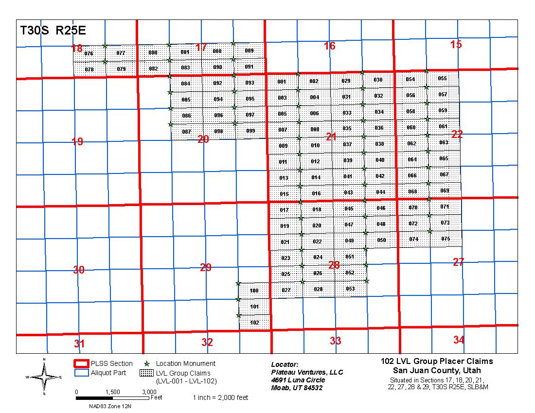
Figure 4.2 - Overview of ABM’s Lisbon Lithium claims in San Juan County, Utah.
Page 12 Lisbon Valley Lithium Project | Prepared for | |
| American Battery Materials, Inc. Technical Report Summary | Lisbon Valley Lithium San Juan County, Utah |
Figure 4.3 below is an example of one of the claim stakes found on the property during the author’s site visit on May 7, 2023. The stake is the location monument for claim number LVL#5.
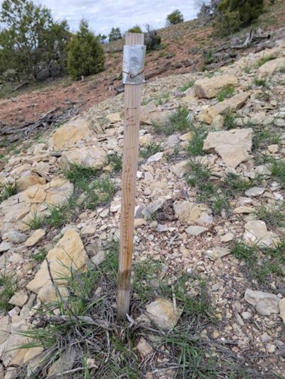
Figure 4.3 – An example of one of the claim stakes found on the property May 7, 2023.
Page 13 Lisbon Valley Lithium Project | Prepared for | |
| American Battery Materials, Inc. Technical Report Summary | Lisbon Valley Lithium San Juan County, Utah |
| 5. | Accessibility, Climate, Local Resources, Infrastructure and Physiography |
Moab, Utah, the nearest population center to the property, is a city of 5,336 persons (2020 Census). It is located in a relatively remote portion of Utah but is easily accessed by U. S. Highway 191. Highway 191 intersects with Interstate 70 about 30 miles (48 kilometers) north of Moab, at Crescent Junction. Moab is a tourist destination and has numerous motels and restaurants. Moab would also be the nearest source of labor in the region.
The region has a history of mining, primarily uranium and vanadium that dates back as far as 1881. The Lisbon Valley Copper Mine is in the heart of the Lisbon Valley and is currently producing copper cathode. An all-weather road and electric power supply the mine.
To access the property from Moab, travel south on Highway 191 for 25 miles (40 kilometers) to La Sal Junction. Turn east on State Highway 49. Travel 7 miles (11 kilometers) and turn south onto Highway 113. Go another 13 miles (21 kilometers) to the northeast corner of the property. A few gravel roads cross the property. Oil and gas drilling and production, along with ranching have made the area relatively accessible.
All the ABM claims fall between elevations of 6200 and 6900 feet (1890 and 2100 meters) above sea level.
It is anticipated that ABM will use a Direct Lithium Extraction (DLE) method rather than using evaporation ponds to recover the lithium and other potential mineral from brines, should the project advance to the production stage. The project should therefore have sufficient space on the ABM claims to construct processing facilities.
The vegetation of the region is sparse, mostly consisting of widely spaced low brush. Juniper and pinion trees are sparsely dispersed on the uplands and are more prevalent in the canyons. Much of the surface is bare rock. Topography is low to moderate but is often steep, or even vertical, where the thick Jurassic sandstone units are cut by the ephemeral streams. Figure 5.1 is a topographic map of the Lisbon Valley area with the ABM claim block superimposed. The contour interval on the map is 40 feet.
At present, ABM does not own water rights in the Lisbon Valley area. The company will need to obtain water rights and a source of fresh water to process the brines and extract lithium, should the property reach production.
Page 14 Lisbon Valley Lithium Project | Prepared for | |
| American Battery Materials, Inc. Technical Report Summary | Lisbon Valley Lithium San Juan County, Utah |

Figure 5.1 – Topographic map underlying the outline of the ABM claim block. CI=40’.
The climate is arid, also termed “high desert”. Moab has average annual precipitation of 9.02 inches (229 mm). In July, the hottest month, it has an average high temperature of 99°F (37°C) and an average low temperature of 65°F (18°C). In January, the coldest month, it has an average high temperature of 43°F (6°C) and an average low of 20°F (-7°C) (Source: Wikipedia.com). The chart below is a graphic representation of the Moab average temperatures (Source: www.usclimatedata.com). The climatic conditions allow for fieldwork to continue throughout the year.
The Paradox Basin covers a large portion of the central part of the Colorado Plateau. The landscape is dominated by thick sections of mostly red Jurassic sandstones cut by streams and rivers into deep, steep-sided canyons. Mattox (1968) describes the Paradox Basin in the following way:
Page 15 Lisbon Valley Lithium Project | Prepared for | |
| American Battery Materials, Inc. Technical Report Summary | Lisbon Valley Lithium San Juan County, Utah |
“The Paradox Basin, here defined as being that area in southeastern Utah and southwestern Colorado that is underlain by saline strata of Pennsylvanian age, has an aerial extent of approximately 1,000 square miles. The climate is essentially arid over much of the basin, the only exceptions being in the Abajo and La Sal Mountains. The vegetation is sparse except in the mountains, where there are heavy stands of timber. The Colorado River traverses the basin, and it and some of its tributaries are permanent streams; in general, however, the streams of the area are ephemeral, and flash flooding is a characteristic phenomenon of their flow.”

Figure 5.2 - Climate data for Moab, Utah.
Page 16 Lisbon Valley Lithium Project | Prepared for | |
| American Battery Materials, Inc. Technical Report Summary | Lisbon Valley Lithium San Juan County, Utah |
| 6. | History |
The Paradox Basin initially attracted attention because of high lithium values reported in the literature in brines recovered from oil and gas exploration wells. The Paradox Basin has been explored for oil and gas for many years (Durgin, 2011). The earliest discoveries of potash in the area were made in 1924 in oil and gas wells, but the correlation of the beds and the extent and richness of the deposits were not recognized until the 1950s. The Seven Mile, Salt Wash and White Cloud potash target areas, all west of Moab, were quickly identified. Further exploration led to the development of the Cane Creek potash mine adjacent to the Colorado River.
Brines were commonly encountered in these wells, but none of the wells was of economic significance for brine until in 1962 when the Southern Natural Gas Company drilled a well, Long Canyon Unit #1, which encountered a substantial flow of high- density brine at a depth of 6,013 feet (Durgin, 2011).
In 1964 the White Cloud #2 well was drilled by J.E. Roberts, 500 feet northeast of the Long Canyon #1 well, specifically for testing the “Brine Zone.” Brine was encountered at 6,013 feet and it was recorded that artesian brine flow was so strong that drilling had to be suspended after penetrating only 6 feet of the 28 foot pay zone. The hole was eventually deepened. Brine from the well was tested by a U. S. Geological Survey laboratory and was reported to contain 1700 ppm lithium (Gwynn, 2008). See note in table 8.20 relating to this reported value.
In 1953 Delhi Oil Corporation explored the Seven Mile area, seven miles NW of Moab, drilling 10 holes on one-half mile centers and identifying a substantial potash resource. In 1956 Delhi identified an excellent potash target at Cane Creek, nine miles south of the Seven Mile area. They drilled 7 test holes there and decided that the Cane Creek target was thicker and higher grade. In 1957 a wildcat oil hole 10 miles west of the Seven Mile area intersected a 16-foot-thick high grade potash bed at the same stratigraphic horizon as Cane Creek and Seven Mile.
In 1960 Texas Gulf Sulfur acquired the Delhi potash properties and was in full production from an underground mine by early in 1965. They announced that the Cane Creek potash bed was 11 feet thick and averaged 25 to 30% potash (Jackson, 1973). The Cane Creek mine, now owned by Intrepid Potash switched to solution mining and solar evaporative precipitation in 1971 and as of Intrepid’s 2020 annual report is still producing at a rate between 75,000 and 120,000 tons of potash per year. Its expected mine life is +100 years with proven and probable reserves at grades of 44.4% and 46.2% KCl, respectively.
Page 17 Lisbon Valley Lithium Project | Prepared for | |
| American Battery Materials, Inc. Technical Report Summary | Lisbon Valley Lithium San Juan County, Utah |
Hite (1978) investigated the potash potential of the Lisbon Valley area in a USGS Open File Report. The analytical report has been the main impetus for the acquisition of the Lisbon Valley Lithium property. Hite examined the available data from oil and gas wells and the potash wells drilled into the Lisbon Valley oil field up until that time. He found significant potential for the development of a potash mine. In Hite’s report, he published the analytical results of a brine sample from the Superior Oil Co. Well Fed 88-21P. Table 6.1 lists the analytical results from Hite’s report and Figure 6.1 shows the location of Fed 88-21 in relation to the ABM claim block.
Table 6.1 - Chemical analysis of brine from the Superior Fed 88-21P well from Hite (1978).
| Compound/Element | % | ppm | ||||||
| Na2O | 9.24 | 92,400 | ||||||
| K2O | 2.91 | 29,100 | ||||||
| Li2O | 0.073 | 730 | ||||||
| CaO | 1.30 | 13,000 | ||||||
| MgO | 7.44 | 74,400 | ||||||
| CO2 | 0.056 | 560 | ||||||
| SO3 | 0.021 | 210 | ||||||
| B2O3 | 0.84 | 8,400 | ||||||
| P2O5 | 0.0009 | 9 | ||||||
| Cl | 19.44 | 194,400 | ||||||
| Br | 0.32 | 3,200 | ||||||
| I | 0.003 | 30 | ||||||
The analysis for lithium from the brine yielded a value of 0.073% Li2O or 730 ppm. This converts to 340 ppm Li. The analysis also showed high values for other salts that could be recovered as byproducts of lithium production.
Unfortunately, at the time the brine sample was collected, it was uncertain which horizon was producing the brine flow. As Hite states:
“The stratigraphic position of the brine source could never be established even though the company cored continuously through the evaporites.”
If the well were to be re-entered, the different zones would need to be isolated and tested to establish which stratigraphic horizons produce brines with the highest lithium values. Based on the casing point and Sueperior 88-21 well’s total depth, the producing horizon lies between 2400 to 3500 feet below the ground surface.
Anson Resources, an Australian company operating in the United States as A1 Lithium Incorporated, has taken their project in the Paradox Basin to the Definitive Feasibility stage (See Section 13 – Adjacent Properties). To date, no lithium production has occurred in the Paradox Basin.
Page 18 Lisbon Valley Lithium Project | Prepared for | |
| American Battery Materials, Inc. Technical Report Summary | Lisbon Valley Lithium San Juan County, Utah |
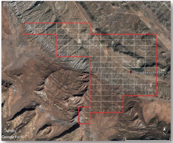
Figure 6.1 - Lisbon Valley Lithium claims in relation to the Superior Peterson Fed 88- 21P well.
Page 19 Lisbon Valley Lithium Project | Prepared for | |
| American Battery Materials, Inc. Technical Report Summary | Lisbon Valley Lithium San Juan County, Utah |
| 7. | Geologic Setting and Mineralization |
The Paradox Basin is an oval-shaped area located in southeastern Utah and southwestern Colorado that may be defined by the maximum extent of salt deposits in the Paradox Formation (formerly referred to as the Hermosa Formation of Middle Pennsylvanian age (Hite and others, 1984; Nuccio and Condon, 1996). The basin was primarily a Pennsylvanian and Permian feature that accumulated thick deposits of carbonate, halite, and clastic rocks in response to downwarping and uplift along its northeastern basin. The basin was later modified, largely due to the Laramide Orogeny 50 to 70 million years (Ma) ago. Today the basin has been eroded in places by uplift of the Colorado Plateau and downcutting by the Colorado River and its tributaries (Nuccio and Condon, 1996). Figure 7.1 shows the structural features in and surrounding the Paradox Basin.
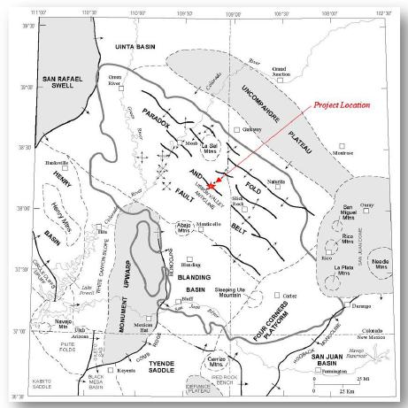
Figure 7.1 - Structural elements of the Paradox Basin and adjacent areas (from Nuccio and Condon, 1996).
Page 20 Lisbon Valley Lithium Project | Prepared for | |
| American Battery Materials, Inc. Technical Report Summary | Lisbon Valley Lithium San Juan County, Utah |
| 7.1 | Stratigraphy |
The Paradox Basin is composed of sedimentary rocks that overlie an Early Proterozoic basement of metamorphic gneiss and schist that is locally intruded by granite (Nuccio and Condon, 1996; Tweto,1987). A stratigraphic column of the basin is presented in Figure 7.2. Cambrian through Jurassic sedimentary rocks unconformably overlie the basement rock in much of the basin. Cretaceous rocks are also noted in the southeastern part of the basin.
The collision of the Laurentia and Gondwana super-continents in the Pennsylvanian and Permian affected the basin, as the Uncompahgre Plateau to the northeast experienced rapid and large-scale uplift as the northeastern side of the basin subsided. All Cambrian through Mississippian rocks were eroded from the plateau as well as some of the Precambrian rocks. Isopach maps in Nuccio and Condon (1996) show that as much as 12,000 feet of sediment accumulated in a trough to the southwest of the Uncompahgre Plateau during Pennsylvanian and Permian time. Deposits of the Pennsylvanian Period, in ascending order, include the Molas Formation, Hermosa Group, Paradox Formation, and Honaker Trail Formation. The Molas Formation is transitional from nonmarine to marine, with marine limestone deposited by the transgressive Middle Pennsylvanian sea.
The Middle and Upper Pennsylvanian Hermosa Group makes up most of the Pennsylvanian strata in the basin. From oldest to youngest, the Hermosa includes the Pinkerton Trail, Paradox, and Honaker Trail Formations (Wengerd and Metheny, 1958). The Pinkerton Trail Formation is composed of interbedded marine limestone and dark shale, deposited in shallow marine conditions of normal salinity.
The Paradox Formation, which is of primary interest to this study, contains dolomite, black shale, anhydrite, halite, and other salts. The lithium-rich brines of the Paradox Basin have all been derived from the Paradox Formation. Halite is the most abundant rock type, occurring in beds tens of feet thick. The black, dolomitic shale is the source rock of some of the oil and gas recovered in the basin. The Paradox was deposited in a series of cycles that represent repeated desiccation and marine flooding of the basin (Hite and Buchner, 1981). In the southwestern part of the basin, the Paradox Formation grades into shelf carbonates, including algal-mound deposits that have served as oil and gas reservoir rocks. In the easternmost part of the basin, the Paradox Formation cannot be differentiated. The black shales of the Paradox have been used as marker beds to correlate depositional cycles throughout the basin. The cycles have been grouped into larger zones, or “substages” (Barnes and others, 1967), or “production intervals” (Hite and others, 1984). Figure 6 is a correlation chart showing the stratigraphy across the Paradox Basin.
For references regarding the sedimentary units lying above the Hermosa Group, additional information can be found in Campbell (1980), Wengerd and Metheny (1958), Nuccio and Condon (1996), Huntoon (1992), Huntoon, et al (1994), Dubiel (1989), Stewart, et al (1972), Pipiringos and O’Sullivan (1978), Peterson and Turner-Peterson (1987), Turner and Fishman (1991), Molenaar (1981), Robinson (1972), McDonald (1972), Spieker (1949), Fouch (1976), and Fouch et al (1983).
Figure 7.2 below is the generalized stratigraphic nomenclature within the greater Paradox Basin area. North American series names have been added for the Mississippian, Pennsylvanian and Permian; however, there is not an intended exact respective match with the formations. Formations assigned to the Hermosa Group are after Rasmussen, D.L. and L. Rasmussen (2009) and Rasmussen (2014). The halite- and potash-bearing interval is marked by green shading. Regional unconformities are shown by the undulating line separating some formations and groups.
Page 21 Lisbon Valley Lithium Project | Prepared for | |
| American Battery Materials, Inc. Technical Report Summary | Lisbon Valley Lithium San Juan County, Utah |
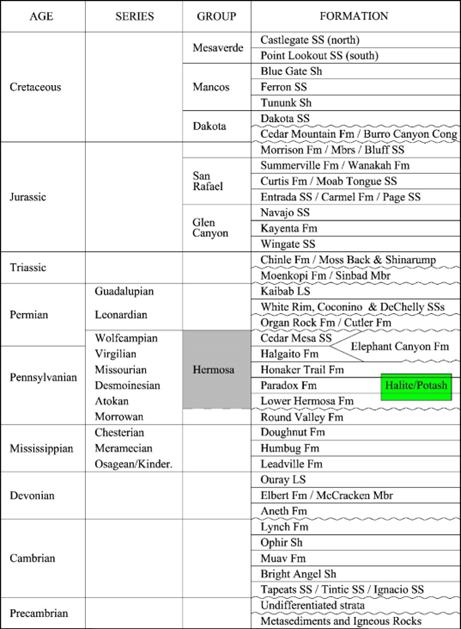
Figure 7.2 - Generalized stratigraphic nomenclature within the greater Paradox Basin area.
Page 22 Lisbon Valley Lithium Project | Prepared for | |
| American Battery Materials, Inc. Technical Report Summary | Lisbon Valley Lithium San Juan County, Utah |
The ABM claims are primarily underlain by Pennsylvanian and Permian sedimentary units. Figure 7.3 shows the surficial geology on and around the LVL claim block.
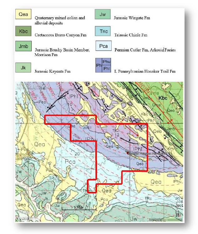
Figure 7.3 - Geologic map of the LVL claim area outlined in red. Modified after Doelling (2002). The Lisbon Valley Fault trend in shown in the block dotted line in NE quadrant of the map below.
Page 23 Lisbon Valley Lithium Project | Prepared for | |
| American Battery Materials, Inc. Technical Report Summary | Lisbon Valley Lithium San Juan County, Utah |
Structure
The primary structure in the area of the ABM claims is the Lisbon Valley Anticline. The Lisbon Valley Anticline was originally identified by gravity anomaly in 1959 (Figure 7.5a) and later supported by 2D seismic surveys and subsurface mapping using available oil and gas well data. The structure is a 4-way anticlinal closure that is cut by a large listric normal fault on its northeast side by the NW/SE trending, down to the northeast, Lisbon Valley Fault (shown in Figure 7.3). The Lisbon Valley Fault zone can be traced on the surface (northwest and southeast trend) for a distance of 41 miles (66 km). The fault and anticline are the result of salt tectonics prevalent in the Paradox Basin (Hite, 1978). Bedding and dip of the Paradox and younger sedimentary rocks generally conform to the structure map presented in Figure 7.5a, showing the top of salt. On the crest of the anticline, salt dissolution has occurred in the upper salt members and salt/clastics zones are highly folded and, in some cases, faulted with increasing depth. Figure 7.4 is a cross section across the NW flank of the Lisbon Valley Anticline showing Robert Hite’s interpretation of the intense structural deformation caused by salt flowage (from Hite 1978). It is important to note that the ABM claims sit on the southeast flank of the Lisbon Valley Anticline where deformation is less prevalent, and individual beds are mappable. Salt is typically encountered between 2200 and 2500 feet below ground level and is generally 6500’ thick in vicinity of the ABM claims area.
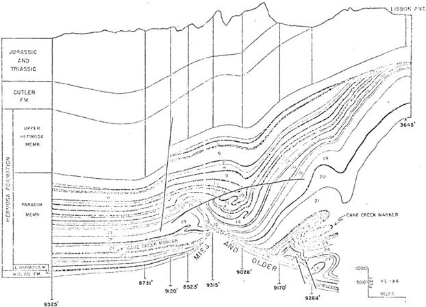
Figure 7.4 – W-E Cross section through the Lisbon Oil field on the north flank of the Lisbon Valley Anticline.
Page 24 Lisbon Valley Lithium Project | Prepared for | |
| American Battery Materials, Inc. Technical Report Summary | Lisbon Valley Lithium San Juan County, Utah |
| 7.2 | Geophysics |
No geophysical surveys have been conducted by ABM on the property. There are numerous 2D seismic lines and a single 3D seismic survey in the vicinity of the ABM claims that may be purchased, but these have not been pursued at this point in time.
A published study (Byerly and Joesting, 1959) included a gravity survey across Lisbon Valley. The three and two-dimensional survey results are shown in Figures 7.5a and 7.5b. The gravity anomalies are caused by density contrasts and changes in thickness of the evaporites in the Paradox Formation relative to the other intrabasement rocks. In general, these early geophysical results match up very well to standard subsurface mapping using formation tops identified in the later oil and gas well logs. (Section 9 – Exploration).
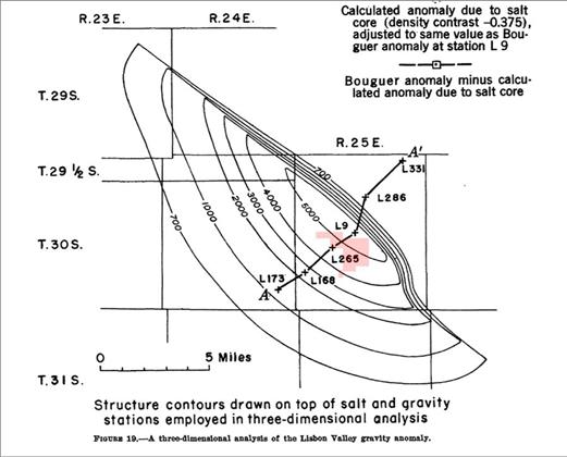
Figure 7.5a - Three-dimensional analysis of the Lisbon Valley gravity anomaly (Byerly and Joesting, 1959).
Page 25 Lisbon Valley Lithium Project | Prepared for | |
| American Battery Materials, Inc. Technical Report Summary | Lisbon Valley Lithium San Juan County, Utah |
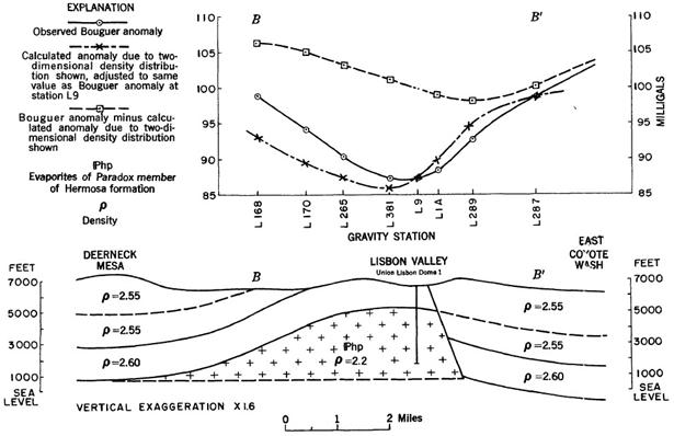
Figure 7.5b – Two-dimensional analysis of the Lisbon Valley gravity anomaly (Byerly and Joesting, 1959).
| 8. | Deposit Types |
There is currently no known production of lithium from the Paradox Basin. The deposit model and exploration target for the Lisbon Lithium Project is very similar to the model defined by Anson Resources in the Paradox Basin to the northwest of ABM’s claim block (See Section 13 – Adjacent Properties). Anson, an Australian company, operating in the U. S. as A1 Lithium Incorporated, has defined a major lithium and bromine resource and has completed a Definitive Feasibility Study. ABM’s target deposit model is similar in all respects to that of Anson’s deposit.
Page 26 Lisbon Valley Lithium Project | Prepared for | |
| American Battery Materials, Inc. Technical Report Summary | Lisbon Valley Lithium San Juan County, Utah |
In the Paradox Basin the lithium-rich brines occur in the “saline facies” of the Paradox Member of the Hermosa Formation of Pennsylvanian age and are totally in the subsurface. The “saline facies” of the Paradox Formation is composed of at least 29 evaporite cycles. Many of the cycles are potash-bearing and there is an active potash mine in the basin. Each cycle, if complete, consists of, in ascending order, (1) limestone, (2) dolomite, (3) anhydrite, and (4) halite with or without potash salts. The sequence is then repeated in a reverse order of (3) anhydrite, (2) dolomite, and (1) limestone to complete the cycle. Units 1, 2 and 3 of each cycle include some clastic material that is commonly euxinic black shale, mudstone, and siltstone. A complete vertical succession in any one cycle is not everywhere present because of a lateral gradation from a hypersaline or saline facies in the basin deep to a limestone facies on the basin shelf. Thus, in the basin deep, only units 3 and 4 may be present, while at some point intermediate between the basin deep and basin shelf all units may be present, and the vertical succession is complete (Hite, 1961).
Halite (NaCl), anhydrite (CaSO4), carnallite (KMgCl3·6H2O), and sylvite (KCl) are the most common evaporite minerals in the Paradox Formation. Halite is the most common salt, totaling over ten thousand feet of thickness in some wells (Mayhew and Heylman, 1966). Anhydrite is also common in dolomite and black shale in the clastic breaks that separate the salt beds.
Depths to the base of the Paradox Formation range from 3,500 feet to over 15,000 feet, depending on the structure and the topographic location (Mayhew and Heylman, 1965). The Paradox Formation is almost entirely in the subsurface, coming to surface only in some salt-cored anticlines in the eastern part of the area, but these are not known to contain lithium-rich brines. As previously noted in section 7.2 (Structure) of this report, the top of salt is generally encountered between 2200 and 2500 feet below ground level in the vicinity of the ABM claims.
The method of extraction of the lithium from the brines is foreseen to be by Direct Lithium Extraction (DLE) and reinjection of the processed brine back into the subsurface. This method has been gaining favor in the lithium industry over the last several years because it does not involve the use of evaporation ponds. DLE uses a much smaller footprint than evaporation ponds and is therefore more acceptable from an environmental standpoint. As yet, ABM has not done any testing for the possibility of using DLE and will not be able to do any testing until samples of brine are acquired from the target formations.
| 8.1 | Brines |
The brines were not considered important until 1962, when Southern Natural Gas intersected the brine zone and a very substantial flow of brines under tremendous pressure. A second well was drilled 500 feet (152 meters) northeast of the first well and encountered flows estimated to be in excess of 50,000 barrels of brine per day. The brine was at a temperature of 145°F (62.8°C).
Many of the early oil and gas wells drilled into the brine zones encountered over- pressured brines and some well blowouts resulted. There are several instances of wells with shut-in pressures between 3,000 and 4,000 psi. The brines tend to be super saturated with a large area of the basin reporting more than 400,000 ppm total dissolved solids (40% solids). In addition to lithium, there is potential to produce other minerals from the brines, including magnesium, boron, bromine and potassium salts. There is also potential for the production of oil and gas.
Partial analyses are available from over 200 brine samples taken from wells in southeastern Utah (Mayhew and Heylman, 1965). Analyses from 17 wells are recorded below (Tables 8.1- 8.20). As can be seen, the composition of the brines varies considerably in the different parts of the basin. Most of the wells are somewhat distant from the LVL claims but are important in that they show some of the levels of the different elements in the brines found in the Paradox Formation. Brine analyses shown in these tables are not necessarily indicative of brines to be tested from beneath the ABM claims.
Page 27 Lisbon Valley Lithium Project | Prepared for | |
| American Battery Materials, Inc. Technical Report Summary | Lisbon Valley Lithium San Juan County, Utah |
Table 8.1 - Amerada Petroleum No. 2 Green River
Section 2, T22S, R16E, Grand County, Paradox Formation. Analysis by California Testing Laboratories.
| Compound | Concentration, ppm | |||
| Bicarbonate | 919 | |||
| Borate | 2,362 | |||
| Calcium | 76,176 | |||
| Carbonate | 0 | |||
| Chloride | 249,600 | |||
| Magnesium | 9,484 | |||
| Sodium | 58,301 | |||
| Sulfate | 49 | |||
| Silica | 10 | |||
| Total solids | 397,061 | |||
| pH | 6.3 | |||
Table 8.2 - British-American No. 1 Gov’t.-Norwood
Section 15, T40S, R22E., San Juan County, Paradox Formation, Desert Creek zone, 5802-5812 feet. Analysis by Core Laboratories.
| Compound | Concentration, ppm | |||
| Barium | 0 | |||
| Bicarbonate | 220 | |||
| Calcium | 25,600 | |||
| Carbonate | 0 | |||
| Chloride | 171,820 | |||
| Magnesium | 2,916 | |||
| Sodium | 78,513 | |||
| Sulfate | 4,185 | |||
| Total Solids | 283,402 | |||
| pH | 5.0 | |||
| Specific Gravity (70ºF) | 1.17 | |||
Page 28 Lisbon Valley Lithium Project | Prepared for | |
| American Battery Materials, Inc. Technical Report Summary | Lisbon Valley Lithium San Juan County, Utah |
Table 8.3 - California Oil No. 1, Navajo 177
Section 3, T40S, R24E, San Juan County, Paradox Formation, 5612-1622 feet. Analysis by Chemical and Geological Laboratories.
| Compound | Concentration, ppm | |||
| Bicarbonate | 255 | |||
| Calcium | 24,200 | |||
| Carbonate | 0 | |||
| Chloride | 182,000 | |||
| Magnesium | 5,073 | |||
| Sodium | 80,872 | |||
| Sulfate | 286 | |||
| Total solids | 304,500 | |||
| pH | 5.4 | |||
| Specific Gravity (70ºF) | 1.18 | |||
Table 8.4 - Delhi-Taylor No. 2, Seven Mile
Section 18, T25S, R21E, Grand Cony. Paradox Formation (From Hite, 1963).
| Compound | Concentration, ppm | |||
| Aluminum | 66 | |||
| Ammonia | 849 | |||
| Bicarbonate | 1,010 | |||
| Boron | 660 | |||
| Bromine | 3,080 | |||
| Calcium | 52,700 | |||
| Chloride | 241,000 | |||
| Copper | 6 | |||
| Fluorine | 25 | |||
| Iodine | 42 | |||
| Iron | 750 | |||
| Lead | 6 | |||
| Lithium | 66 | |||
| Magnesium | 39,200 | |||
| Manganese | 260 | |||
| Potassium | 18,800 | |||
| Sodium | 5,990 | |||
| Sulfate | 4 | |||
| Zinc | 60 | |||
| Total solids | 366,000 | |||
Page 29 Lisbon Valley Lithium Project | Prepared for | |
| American Battery Materials, Inc. Technical Report Summary | Lisbon Valley Lithium San Juan County, Utah |
Table 8.5 - Humble No. 1 Rustler Dome
Section 4, R29, R20E, San Juan County. Mississippian 4905-5076 feet. Analysis by Core Laboratories.
| Compound | Concentration, ppm | |||
| Calcium | 12,000 | |||
| Chloride | 208,740 | |||
| Magnesium | 4,860 | |||
| Sodium | 115,335 | |||
| Sulfate | 6,770 | |||
| Total solids | 348,681 | |||
| pH | 5.0 | |||
| Specific Gravity | 1.2 | |||
Table 8.6 - King Oil No. 2 Big Flat
Section 11, T26S, R19E, Grand County. Paradox Formation, 6196-6220 feet. Analysis by Chemical and Geological Laboratories.
| Compound | Concentration, ppm | |||
| Ammonia | 1,330 | |||
| Borate (B4O7) | 2,922 | |||
| Bromine | 1,150 | |||
| Calcium | 40,742 | |||
| Chloride | 259,106 | |||
| Lithium | 173 | |||
| Magnesium | 47,789 | |||
| Potassium | 41,957 | |||
| Sodium | 25,966 | |||
| Sulfate | 754 | |||
| Total solids | 421,889 | |||
Table 8.7 - Pure Oil No. 1 Hobson-USA
Section 30, T26S, R20E, Grand County. Paradox Formation, 5425-5435 feet. Analysis by Ethyl Corporation.
| Compound | Concentration, ppm | |||
| Boron | 1,260 | |||
| Bromine | 1,612 | |||
| Calcium | 55,740 | |||
| Chlorine | 249,300 | |||
| Lithium | 134 | |||
| Magnesium | 31,350 | |||
| Potassium | 25,500 | |||
| Sodium | 22,000 | |||
| Strontium | 1,300 | |||
| Sulfate | 23 | |||
Page 30 Lisbon Valley Lithium Project | Prepared for | |
| American Battery Materials, Inc. Technical Report Summary | Lisbon Valley Lithium San Juan County, Utah |
Table 8.8 - Pure Oil No. 1 Hobson-USA
Section 30, T26S, R20E, Grand County. Paradox Formation. Analysis of solids collected from tubing. Analysis by Titanium Metals.
| Compound | Concentration, (%) | |||
| Boron | 0.19 | % | ||
| Bromine | 3.42 | |||
| Calcium | 1.23 | |||
| Chloride | 70.70 | |||
| Copper | 0.001 | |||
| Iron | 0.20 | |||
| Lithium | 0.002 | |||
| Magnesium | 1.20 | |||
| Potassium | 12.25 | |||
| Sodium | 10.60 | |||
| Strontium | 0.50 | |||
| Sulfate | 0.0 | |||
Table 8.9 - Pure Oil No. 2 Big Flat
Section 14, T26S, R19E, Grand County. Mississippian, approximately 7,200 feet. Analysis by Ethyl Corporation.
| Compound | Concentration, (ppm) | |||
| Boron | 780 | |||
| Bromine | 2,041 | |||
| Calcium | 41,800 | |||
| Chlorine | 210,500 | |||
| Lithium | 81 | |||
| Magnesium | 33,100 | |||
| Potassium | 21,000 | |||
| Sodium | 9,100 | |||
| Sulfate | 31 | |||
Page 31 Lisbon Valley Lithium Project | Prepared for | |
| American Battery Materials, Inc. Technical Report Summary | Lisbon Valley Lithium San Juan County, Utah |
Table 8.10 - Roberts Brine Well
Section 9, T26S, R20E, Grand County. Paradox Formation (sample collected from drippage at well head). Analysis by Ford Chemical Laboratories.
| Compound | Concentration, (ppm) | |||
| Bicarbonate | 0 | |||
| Boron | 20,000 | |||
| Bromine | 2,500 | |||
| Calcium | 3,000 | |||
| Carbonate | 200 | |||
| Chlorine | 53,000 | |||
| Iodine | 450 | |||
| Magnesium | 34,000 | |||
| Phosphate | 15 | |||
| Potassium | 33,000 | |||
| Sodium | 43,000 | |||
| Sulfate | 500 | |||
| Total solids | 250,000 | |||
| pH | 6.1 | |||
Table 8.11 - Southern Natural No. 1 Long Canyon
Section 9, T26S, R20E, Grand County. Paradox Formation, Cane Marker, 7050-7075 feet. Brine produced with oil, collected from separator. Analysis by Ford Chemical Laboratory.
| Compound | Concentration, (ppm) | |||
| Bicarbonate | 1,600 | |||
| Boron | 600 | |||
| Bromine | 3,000 | |||
| Calcium | 34,000 | |||
| Carbonate | 2,200 | |||
| Chloride | 45,000 | |||
| Iodine | 300 | |||
| Magnesium | 21,000 | |||
| Phosphate | 2,000 | |||
| Potassium | 20,000 | |||
| Sodium | 13,000 | |||
| Sulfate | 1,800 | |||
| Total solids | 388,000 | |||
| pH | 4.8 | |||
Page 32 Lisbon Valley Lithium Project | Prepared for | |
| American Battery Materials, Inc. Technical Report Summary | Lisbon Valley Lithium San Juan County, Utah |
Table 8.12 - Southern Natural No. 1 Long Canyon
Section 9, T26S, R20E, Grand County. Paradox Formation, clastic zone 31. Analysis by U.S. Geological Survey.
| Compound | Concentration, (ppm) | |||
| Bicarbonate | 1,400 | |||
| Bromine | 6,100 | |||
| Calcium | 65,800 | |||
| Chloride | 29,800 | |||
| Lithium | 500 | |||
| Magnesium | 45,500 | |||
| Nitrate | 6 | |||
| Potassium | 23,400 | |||
| Rubidium | 700 | |||
| Sodium | 9,800 | |||
| Sulfate | 80 | |||
| Total solids | 439,000 | |||
| pH | 6.0 | |||
| Specific Gravity (24ºC) | 1.37 | |||
Table 8.13 - Suburban Storage No. 1
Section 26, T25S, R21E, Grand County. Paradox Formation. Sample taken from zone in which storage cavity was washed. This zone includes one bed of sylvite and one bed of carnallite.
| Compound | Concentration, (ppm) | |||
| Bicarbonate | 110 | |||
| Calcium | 648 | |||
| Carbonate | 0 | |||
| Chloride | 182,730 | |||
| Magnesium | 1,388 | |||
| Potassium | 7,460 | |||
| Sodium | 116,923 | |||
| Total solids | 322,059 | |||
| Specific Gravity (60ºF) | 1.21 | |||
Page 33 Lisbon Valley Lithium Project | Prepared for | |
| American Battery Materials, Inc. Technical Report Summary | Lisbon Valley Lithium San Juan County, Utah |
Table 8.14 - Superior No. 22-34 Salt Wash
Section 34, T22S, R17E, Grand County. Mississippian, 10,053-10,173 feet. Analysis by Superior Oil Company.
| Compound | Concentration, (ppm) | |||
| Bicarbonate | 169 | |||
| Calcium | 5,563 | |||
| Carbonate | 0 | |||
| Chloride | 152,698 | |||
| Magnesium | 1,383 | |||
| Sodium & Potassium | 90,949 | |||
| Sulfate | 1,768 | |||
| Total solids | 251,719 | |||
| pH | 6.7 | |||
| Specific Gravity (60ºF) | 1.18 | |||
Table 8.15 - Superior No. 14-5 Bowknot
Section 5, T26S, R17E, Emery County. Mississippian, 6,270-6,350 feet. Analysis by Core Laboratories.
| Compound | Concentration, (ppm) | |||
| Barium | 0 | |||
| Bicarbonate | 146 | |||
| Calcium | 240 | |||
| Carbonate | 0 | |||
| Chloride | 171,820 | |||
| Magnesium | 266 | |||
| Sodium | 110,004 | |||
| Sulfate | 240 | |||
| Total solids | 283,720 | |||
| pH | 5.0 | |||
Page 34 Lisbon Valley Lithium Project | Prepared for | |
| American Battery Materials, Inc. Technical Report Summary | Lisbon Valley Lithium San Juan County, Utah |
Table 8.16 - Texaco No. 2 Navajo AC
Section 34, T40 S, R26 E, San Juan County. Paradox Formation (Ismay zone). Analysis by Core Laboratories.
| Compound | Concentration, (ppm) | |||
| Barium | 0 | |||
| Bicarbonate | 488 | |||
| Calcium | 3,600 | |||
| Carbonate | 0 | |||
| Chloride | 205,900 | |||
| Iron | 0 | |||
| Magnesium | 7,533 | |||
| Sodium | 115,455 | |||
| Sulfate | 200 | |||
| Total Solids | 333,176 | |||
| pH | 4.5 | |||
| Specific Gravity (66ºF) | 1.13 | |||
Table 8.17 - Texaco No. 1 Smoot (Salt Wash field)
Section 17, T23S, R17E, Grand County. Mississippian, 8785-8876 feet. Analysis by Rocky Mountain Engineering Company.
| Compound | Concentration, (ppm) | |||
| Bicarbonate | 951 | |||
| Calcium | 2,865 | |||
| Carbonate | 0 | |||
| Chloride | 190,640 | |||
| Magnesium | 1,801 | |||
| Sodium | 119,418 | |||
| Sulfate | 4,320 | |||
| Total Solids | 324,656 | |||
| pH | 6.0 | |||
| Specific Gravity (70ºF) | 1.14 | |||
Page 35 Lisbon Valley Lithium Project | Prepared for | |
| American Battery Materials, Inc. Technical Report Summary | Lisbon Valley Lithium San Juan County, Utah |
Table 8.18 - Tidewater No. 74-11 Big Flat
Section 11, T26S, R19E, Grand County. Paradox Formation, interval 5920-5950. Analysis by Chemical and Geological Laboratories.
| Compound | Concentration, (ppm) | |||
| Bicarbonate | 890 | |||
| Calcium | 32,900 | |||
| Chloride | 132,810 | |||
| Magnesium | 23,800 | |||
| Sodium & Potassium | 36,283 | |||
| Sulfate | 323 | |||
| Total Solids | 338,952 | |||
| pH | 5.7 | |||
Table 8.19 - Tidewater No. 74-11 Big Flat
Section 11, T26S, R19E, Grand County. Paradox Formation, clastic zone 31. Analysis by U.S. Geological Survey.
| Compound | Concentration, (%) | |||
| Calcium Chloride | 11.36 | |||
| Magnesium Chloride | 15.31 | |||
| Potassium Chloride | 4.32 | |||
| Total Chloride | 22.40 | |||
| Total Sulfate | 0.04 | |||
Table 8.20 - White Cloud #2 (aka. Roberts Brine Well)
Section 9, T26S, R20E Grand County. Analysis by the U. S. Geological Survey (Gwynn, 2008).
| Compound | Concentration, (ppm) | |||
| Sodium | 28,500 | |||
| Potassium | 47,000 | |||
| Lithium | 1,700 | * | ||
| Calcium | 46,700 | |||
| Magnesium | 43,600 | |||
| Total Halides as Chorine | 184,200 | |||
| Specific Gravity (23ºC) | 1,282 | |||
| * | According to a website release by the TRU Group (trugroup.com), the 1,700 ppm Li value quoted above for the White Cloud #2 well brine is incorrect. They present evidence from unpublished sources that the value is off by a factor of 10 and the actual value should be 170 ppm Li. |
Page 36 Lisbon Valley Lithium Project | Prepared for | |
| American Battery Materials, Inc. Technical Report Summary | Lisbon Valley Lithium San Juan County, Utah |
| 8.2 | Wells Located on the Subject Property |
Seven oil and gas wells have been drilled on the property now held by ABM according to records of the Utah Division of Oil, Gas and Mining. Unfortunately, no analyses of the brines from these wells have been found in the literature. Six of the wells have been plugged and abandoned. One well is being used as a water disposal well. The seven wells are:
Table 8.21 - Oil & gas wells drilled within the LVL claim block.
| Location | ||||||||||||||||||||||||
| API | Drilled By | Well Name | Sec | 1/4 Sec | Elev (ft) | Year Drilled | TD (ft) | Current Status | ||||||||||||||||
43-037-30029 | Union Oil | Little Valley Federal #1 | 18 | SWSE | 6318 | 1969 | 9100 | P&A | ||||||||||||||||
43-037-30464 | Cordillera Corp | Federal 1-20 | 20 | NENE | 6750 | 1980 | 9555 | Disposal | ||||||||||||||||
43-037-15768 | Pubco Petroleum | Lisbon Federal 2-21F | 21 | SENW | 6864 | 1961 | 9560 | P&A | ||||||||||||||||
43-037-30436 | Mesa Petroleum | Lisbon Federal 21-3 | 21 | NWNE | 6710 | 1978 | 9953 | P&A | ||||||||||||||||
43-037-10944 | Pubco Petroleum | Lisbon Federal 3-27C | 27 | NENW | 6679 | 1962 | 9580 | P&A | ||||||||||||||||
43-037-10807 | Pacific Natural Gas | Little Valley #1 | 28 | SWNW | 6521 | 1963 | 9712 | P&A | ||||||||||||||||
43-037-10808 | Pacific Natural Gas | Little Valley #2 | 29 | SESE | 6528 | 1964 | 8964 | P&A | ||||||||||||||||
All the wells are in Township 30S, Range 25E of the Salt Lake Principal Meridian. The Superior Fed 88-21P Well does not appear in this table since it was not drilled for oil and gas, but for potash. Data for potash exploration are not posted by the Utah Geological Survey. The locations of the oil and gas wells occurring on the ABM claims are shown in Figure 8.1.
Page 37 Lisbon Valley Lithium Project | Prepared for | |
| American Battery Materials, Inc. Technical Report Summary | Lisbon Valley Lithium San Juan County, Utah |
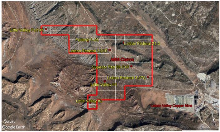
Figure 8.1 – Oil and gas wells occurring on the ABM claims.
Page 38 Lisbon Valley Lithium Project | Prepared for | |
| American Battery Materials, Inc. Technical Report Summary | Lisbon Valley Lithium San Juan County, Utah |
| 9. | Exploration |
There has been no exploration conducted on the property by ABM or its predecessors other than the gathering and assimilation of data from all available sources.
A thorough review of 40 historic well files and corresponding well log data was conducted in the fall and winter of 2022-2023. Formation tops were picked in 23 of the available 40 wells that penetrated some or all of the Paradox salts/clastics and/or the Leadville Limestone. Nearly one third of the wells did not penetrate the salts/clastics. Figure 9.1 is a stratigraphic column and type log using the Southern Natural Gas Long Canyon #1 well as an example. This well does not occur within the ABM claims area. It only serves as an example of the stratigraphic section present throughout most of the Paradox Basin. Structure contour maps of the zones have been generated but are currently proprietary. The primary targets include Clastic Zones 17 and 31, as well as the Leadville Limestone. These zones have been shown by historical records and recent production to have free flowing brines with high lithium concentrations – above 200 ppm Li.
Secondary targets are Clastic Zones 19, 29, 33, and 39. These zones have been recently identified by Anson Resources’ drilling and testing (see Section 13 on Adjacent Properties) to contain supersaturated brines with elevated lithium concentrations.
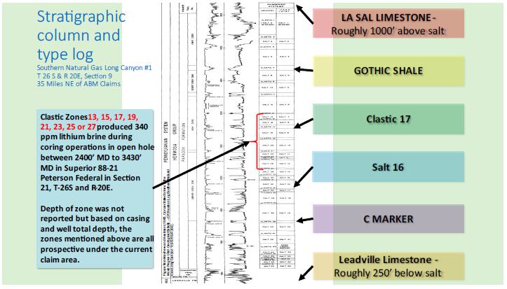
Figure 9.1 – Stratigraphic column and type log for the units showing (Pennsylvanian) clastic and salt section (Mayhew and Heylmann 1965).
Page 39 Lisbon Valley Lithium Project | Prepared for | |
| American Battery Materials, Inc. Technical Report Summary | Lisbon Valley Lithium San Juan County, Utah |
| 10. | Drilling |
No drilling has been conducted by ABM or its predecessors. Drilling has been conducted by oil and gas and by potash interests on and in the area surrounding the LVL claims, which has provided much of the information for this report. ABM is in the process of permitting 2 appraisal wells in Lisbon Valley. Assuming no significant delays are encountered during the review process, the wells will be scheduled for drilling as early as 2023Q4 and 2024Q1. It is important to note that two historical wells within or in close proximity to the claims block took kicks and presumably encountered high pressure brines or gases during drilling or coring operations within the clastic/salt sections. The Superior 88-21 Federal in Section 21 T 30S and R25E (discussed in section 6) encountered a high-pressure brine between 2500 and 3400 feet measured depth and the Pure Oil Spiller Canyon #1 in Section 16, T30S and R 25E (less than 1500 feet from northern claim boundary) encountered high pressure while drilling the Cane Creek Marker (Clastic 43) at 4700 feet measured depth. The chemistry of the brine from the Superior 88-21 well is discussed further in this report. There is no sample data reported from the Pure Oil Spiller Canyon #1 well.
| 11. | Sample Preparation, Analyses and Security |
No sampling has been conducted by ABM or its predecessors. No information is available concerning the procedures used by the oil and gas or potash companies for sample preparation, analytical techniques or security for the lithium analyses stated in this report.
| 12. | Data Verification |
Data used in this report is mostly from published information and, in a few cases, from unpublished sources. Where possible, the author and the other experts have made efforts to verify the sources of the data.
| 13. | Mineral Processing and Metallurgical Testing |
No metallurgical testing has been conducted by ABM and none can be conducted until brine samples can be collected from wells drilled or re-entered on the subject property. The summary below shows some aspects of the anticipated type of processing envisioned by ABM for extraction of lithium and possibly other commodities from the brines. ABM’s technical team and third-party consultants are reviewing and pursuing available technologies based on the water chemistry from the Superior Oil Company Peterson 88-21 Federal well referenced in Table 6.1
The use of open ponds for evaporation and concentration of lithium brines is nominally inexpensive, however, the evaporation process is time consuming, land intensive and wasteful of water. The development of new brine resources from undeveloped lithium brine deposits is likely to meet significant environmental and social barriers to implementation, particularly in the US, and evaporation ponds are not considered environmentally sustainable.
Over the past decade many direct lithium extraction (DLE) technologies have arisen due to intense research and economic drive to separate lithium from other ions in a feed solution. These processes can involve organic and inorganic sorption reagents based on polymers, membranes, manganese, titanium, or aluminum oxides and form the backbone of DLE extraction technologies. These materials are utilized in DLE projects in China and Argentina to extract lithium from geological brines. Many of these projects have come online over the past 10 years and have been operating successfully producing battery grade lithium materials. It is estimated that approximately 12% of the world’s lithium supply in 2019 was produced using direct lithium extraction technology.
Direct lithium extraction from a brine relies on the ability of a material to “pluck” lithium ions out of a complex geochemical soup, while leaving all other salts and metals in solution. Shown in Figure 13.1 is a typical process flow diagram for a DLE process. DLE technologies are broadly grouped into three main categories: adsorption, ion exchange, and solvent extraction.
Page 40 Lisbon Valley Lithium Project | Prepared for | |
| American Battery Materials, Inc. Technical Report Summary | Lisbon Valley Lithium San Juan County, Utah |
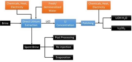
Figure 13.1 - Process flow diagram of a typical lithium extraction process.
| ● | Adsorption physically absorbs LiCl molecules onto the surface of a sorbent from a lithium loaded solution. The lithium is then stripped from the surface of the sorbent with water. | |
| ● | Ion exchange takes lithium ions from the solution and replaces them with a different positively charged cation that is contained in the sorbent material. An acidic (or basic) solution is required to strip the lithium from the material and regenerate the sorbent material. | |
| ● | Solvent extraction removes lithium ions from solution by contacting the solution with an immiscible fluid (i.e., oil or kerosene) that contains a extractant that attaches to lithium ions and brings them into the immiscible fluid. The lithium is then stripped from the fluid with water or chemical treatment. |
Regardless of the method, the product is a solution of LiCl which is concentrated and processed into the final battery grade lithium compounds (LiOH∙H2O or Li2CO3) upon the addition of electricity or chemical inputs.
It is recognized that direct lithium extraction will have higher upfront capital costs than evaporation ponds. A technoeconomic analysis (Warren, 2021) of several brine projects was published in 2021 evaluating several DLE projects. These projects had submitted a Preliminary Economic Assessments (PEA) to Canadian stock exchanges or a Pre- Feasibility Studies (PFS) to Australian stock exchanges (public availability determined by company boards of directors). The range of brine types and lithium extraction processes reviewed herein the report suggest an OPEX near $4,000/mt lithium carbonate equivalent (LCE) is achievable with modeled prices assumed to be >$11,000/mt Li2CO3 and >$12,267/mt LiOH·H2O.
Evaporative technology is 22.5 m3 and 50 m3 per tonne Li2CO3 for Salar de Atacama and Salar de Olaroz, respectively (Orocobre, 2021) (SQM, 2022). With this as a reference, Livent, which has an active DLE production in the Salar del Hombre Muerto since 1996 does not report its freshwater usage. The overall water use of the entire facility is reported as 71 m3 per tonne Li2CO3. (Livent, 2021) The freshwater requirements will be assessed and could change depending on the different methods/materials and if water is recovered during the DLE process.
Page 41 Lisbon Valley Lithium Project | Prepared for | |
| American Battery Materials, Inc. Technical Report Summary | Lisbon Valley Lithium San Juan County, Utah |
| 14. | Adjacent Properties |
There is no known lithium production in the Paradox Basin. The Cane Creek potash mine is located 32 miles (51 kilometers) northwest of the LVL claim group. The mine has been operating since 1965, initially as an underground room and pillar style mine. It was converted to a solution mining operation in 1970. It currently produces 700 to 1000 tons per day of potash from the same sedimentary units that underly ABM’s project. The author has not verified the information about the Cane Creek potash mine and the mineralization reported at the mine is not necessarily indicative of mineralization found on the property that is the subject of this report.
Anson Resources, an Australian company whose properties are primarily west of Moab, Utah, has been active over the past few years in the Paradox Basin. Anson has re- entered four abandoned oil and gas wells and performed extensive testing of the wells’ brine recovery performance and methods for recovering the lithium and bromine from the brines. According to their website, www.ansonresources.com , they have completed a Definitive Feasibility Study (DFS) on September 8, 2022, and have identified substantial indicated and inferred resources of Lithium Carbonate Equivalent (LCE) and Bromine (Br2) as shown in Table 13.1.
Table 14.1 – Anson Resources announced resources from their DFS.
| Category | Brine (Mt) | Li (ppm) | Br (ppm) | Contained LCE (‘000t) | Contained Br2 (‘000t) | |||||||||||||||
| Indicated | 530 | 123 | 3,474 | 346 | 1,840 | |||||||||||||||
| Inferred | 1,038 | 125 | 3,308 | 692 | 3,434 | |||||||||||||||
The financial highlights of the DFS were announced as:
Table 14.2 – Financial highlights from the Anson Resources DFS.
| Scenario | Pre-Tax (USD) | Post-Tax (USD) | ||||||||||||||
| NPV (7%) | IRR | NPV (7%) | IRR | |||||||||||||
| Base Case | $ | 1,306 | m | 47 | % | $ | 922 | m | 37 | % | ||||||
These calculations do not take into account the potential replenishment of the brine zones.
Page 42 Lisbon Valley Lithium Project | Prepared for | |
| American Battery Materials, Inc. Technical Report Summary | Lisbon Valley Lithium San Juan County, Utah |
In 2022, Anson Resources reported flow rates from Clastic Zone 31 on the order of 4000 BSWPD with lithium concentrations of 183 and 216 ppm (respectively); from one-hour tests of Skyline Unit 2 and Long Canyon #2 wells; Anson also reported formation porosities of 20% and tests indicating greater than 1500 mD permeabilities. Given the tight nature of the zones, fracture porosity is strongly indicated. Both wells offset the Southern Natural Gas Long Canyon #1. The Clastic 31 zone is present and mappable in the ABM claims area and is located at shallower depths compared to Cane Creek and Big Flat fields in Grand County to the north of Lisbon Valley where the highest known Li Concentration of 500 ppm occurred from the Southern Natural Gas Long Canyon #1 well.
The location of ABM’s property relative to Anson’s and the Cane Creek Potash Mine is shown in Figure 13.1.
The author of the report herein has been unable to verify the information in the Anson Resources announcement and the mineralization is not necessarily indicative of the mineralization on the property that is the subject of this technical report.
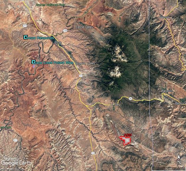
Figure 14.1 – The location of ABM’s Lisbon Lithium Project relative to Anson’s project and the Cane Creek Potash Mine.
Page 43 Lisbon Valley Lithium Project | Prepared for | |
| American Battery Materials, Inc. Technical Report Summary | Lisbon Valley Lithium San Juan County, Utah |
| 15. | Other Relevant Data and Information |
There are no other relevant data and information that must be presented at this time.
| 16. | Interpretation and Conclusions |
There is abundant evidence from oil, gas and potash wells drilled in the Paradox Basin that indicates that there is a high probability of identifying and producing super saturated brines from beneath the ABM property position. The geology of the area of the ABM claims and of the Paradox Basin as a whole is quite complex although zones that have been targeted and proven by Anson Resources exist and they are mappable within and beyond the claims area. It is not likely that the same zones vary significantly in terms of reservoir quality and thickness as evidenced by log analysis, however these parameters have not been confirmed by actual testing by ABM. Given the extensive folding in vicinity of the Lisbon Valley Dome formation, it is believed but not yet confirmed that fracture porosity and permeability may be enhanced within the clastic zones that underly the current claims position.
The only way to determine if the lithium enriched brines exist and can be economically produced from the target zones is to drill exploration wells to produce and test brine from the targeted zones. American Battery Materials intends to drill two exploratory/appraisal wells within its claims position and is currently waiting permit approval. The estimated spud dates for the two wells is expected to be 6-12 months for this report’s effective date.
From the author’s review of the data, it is believed that there is a substantial indication that lithium mineralization in brines occurs beneath the subject property. The existing evidence is based on ABM’s well log analysis and the Hite (1978) study, as well as a substantial number of other studies with lithium analyses from the Paradox Basin. Hite’s report presents a geologically sound picture of the potential brine target. The occurrence of the Superior Fed 88-21P well within the ABM claim block and the recorded lithium value in the Hite study are strong incentives to pursue the exploration effort. There is also substantial evidence that other valuable minerals besides lithium, such as potassium, magnesium, calcium chloride, iodine, bromine and boron, may be recoverable from the brines, as well.
The abandoned/existing oil well re-entry and brine testing program by Anson Resources has resulted in that company’s Definitive Feasibility Study. The same stratigraphic units have been shown to exist beneath the ABM land position and there is clear evidence from Hite (1978) that the brines in the Paradox Formation contain high lithium concentrations. These are considered to be evidence that the Lisbon Lithium project has potential to become an economically viable undertaking. It is anticipated that the target grades and tonnages for the Lisbon Lithium Project will be similar to those reported by Anson Resources, i.e., approximately 1 billion tonnes of brine at +100 ppm Li for a potential 1 million tonnes of LCE. As in the case with Anson Resources and their anticipated recovery of bromine, other elements and salts may well be economically recoverable.
| 17. | Recommendations |
It is recommended that ABM drill and complete two appraisal wells and perform comprehensive testing on key horizons within the Paradox clastic members and Leadville (Mississippian) Limestone. Individual formations should be evaluated for overall reservoir quality, bottom hole pressures and flow rates from conventional completions. Any extracted brines should be tested to determine lithium concentrations and to prove economic viability of a pilot and permanent production program. The company has identified an appraisal and development program that is proprietary. This information will be disclosed in an advanced technical report after the appraisal wells are drilled and individual zones are identified and fully evaluated. ABM has retained a third-party consulting firm to assist with drilling, completion, and review of test results for the two appraisal wells.
Page 44 Lisbon Valley Lithium Project | Prepared for | |
| American Battery Materials, Inc. Technical Report Summary | Lisbon Valley Lithium San Juan County, Utah |
| 18. | References |
Byerly, P. Edward and Joesting, H. R., 1959, Investigations of the Lisbon Valley Area, Utah and Colorado, USGS Professional Paper 316-C, p. 39-50.
Doelling, Hellmut H., 2002, Geologic map of the Moab and eastern part of the San Rafael Desert 30’ X 60’ quadrangles, Grand and Emery Counties, Utah, and Mesa County, Colorado: Utah Geol. Surv. Geologic Map 180.
Durgin, Dana, 2011, Technical Report, Geology and Mineral Resources, Green Energy Project, Grand County, Utah, USA, 34 p.
Gwynn, Wally, 2008, Various Reports and Letters Regarding the White Cloud Property, Grand County, Utah, Utah Geologic Survey files, 67 pages.
Hintze, L.F., 1974, Geologic Map of Utah: Brigham Young University Geology Studies— Special Publication 2.
Hite, R.J., 1961, Potash-bearing Evaporite Cycles in the Salt Anticlines of the Paradox Basin, Colorado and Utah: U. S. Geological Survey Professional Paper 424-D, p. D135-D138.
Hite, R.J., 1978, The Geology of the Lisbon Valley Potash Deposits, San Juan County, Utah: U. S. Geological Survey Open File Report 78-148.
Hite, R.J., and Buchner, D.H., 1981, Stratigraphic correlations, facies concepts, and cyclicity in Pennsylvanian rocks of the Paradox Basin, in Wiegand, D.L., ed., Geology of the Paradox Basin: Rocky Mountain Association of Geologists Guidebook, p. 147-159.
Hite, R.J., Anders, D.E., and Ging, T.G., 1984, Organic–rich source rocks of Pennsylvanian age in the Paradox Basin of Utah and Colorado, in Woodward, Jane, Meissner, F.F., and Clayton, J.L., eds., Hydrocarbon source rocks of the Greater Rocky Mountain Region: Rocky Mountain Association of Geologists Guidebook, p. 255-274.
Hite, R.J., 1961, Potash-bearing evaporite cycles in the salt anticlines of the Paradox Basin, Colorado, and Utah: U.S. Geological Survey Prof. Paper 424-D, p. D135-D138.
Kelley, V.C., 1958, Tectonics of the region of the Paradox Basin: Intermountain Assoc. Petroleum Geologists Guidebook, 9th Annual Field Conference, p. 31-38.
Page 45 Lisbon Valley Lithium Project | Prepared for | |
| American Battery Materials, Inc. Technical Report Summary | Lisbon Valley Lithium San Juan County, Utah |
Livent, 2021, Sustainability Report: Retrieved from https://livent.com/wp- content/uploads/2022/07/Livent_2021SustainabilityReport-English.pdf
Mattox, R. B. 1968, Salt Anticline Field Area, Paradox Basin, Colorado and Utah: Geol. Soc. Of America Special Paper 88, pp. 5-16.
Mayhew, E.J., and Heylman, E.B., 1965, Concentrated Subsurface Bines in the Moab Region, Utah: in Special Studies 13, Utah Geological and Mineralogical Survey, 30 p.
, 1966, Complex Salts and Brines of the Paradox Basin: in Jon L. Rau, Editor, Second Symposium on Salt, Vol. One, The Northern Ohio Geological Society, Inc., Cleveland, Ohio, p. 221-235.
Munk, LeeAnn and Chamberlain, C. Page, 2011, Final Technical Report: G10AP00056 – Lithium Brine Resources: A Predictive Exploration Model: USGS Mineral Resources External Research Program.
Munk, LeeAnn; Hynek, Scott A.; Bradley, Dwight C.; Boutt, David; Labay, Keith; and Jochens, Hillary, 2016: Soc. of Econ. Geol., Reviews in Econ. Geol, V. 18, pp. 339-365.
Nuccio, V.F., and Condon, S.M., 1996, Burial and Thermal History of the Paradox Basin, Utah and Colorado, and Petroleum Potential of the Middle Pennsylvanian Paradox Formation: U.S. Geological Survey Bulletin 2000-O, p. O1-O41.
Orocobre, 2021, Sustainability Report: Retrieved from https://www.orocobre.com/wp/?mdocs-file=7259.
Pipiringos, G.N., and O’Sullivan, R.B., 1978, Principal unconformities in Triassic and Jurassic rocks, Western Interior United States; a preliminary survey: U.S. Geological Survey Professional Paper 1035-A, 29 p.
Rasmussen, L., and Rasmussen, D.L., 2009, Burial history analysis of the Pennsylvanian petroleum system in the deep Paradox Basin Fold and Fault Belt, Colorado and Utah, in Houston, W.S., Wray, L.L., and Moreland, P.G., editors, The Paradox Basin revisited—new developments in petroleum systems and basin analysis: Rocky Mountain Association of Geologists Special Publication, p. 24-94.
Rasmussen, D.L., 2014, Namakiers in Triassic and Permian formations in the Paradox Basin (USA) with comparisons to modern examples in the Zagros Fold Belt, Iran, in MacLean,
Page 46 Lisbon Valley Lithium Project | Prepared for | |
| American Battery Materials, Inc. Technical Report Summary | Lisbon Valley Lithium San Juan County, Utah |
J.S., Biek, R.F., and Huntoon, J.E., editors, Geology of Utah’s Far South: Utah Geological Association Publication 43, p. 689-756.
Severy, C.L., Kline, M.H., and Allsman, P.T, 1949, Investigations of the Thompson magnesium well: U.S. Bureau of Mines Rept. Inv. 4496.
Spanjurs, Raymond P., 2015, Inferred Resource Estimate of Lithium, Clayton Valley South Project, Clayton Valley, Esmeralda County, Nevada, USA: Technical Report for NI 43-101, Prepared on Behalf of Pure Energy Minerals Ltd.
SQM, 2022, Sustainability report: Retrieved from https://www.sqmlithium.com/en/nosotros/producion-sustentable/.
Stewart, J.H., Poole, F.G., and Wilson, R.F., 1972, Stratigraphy and origin of the Triassic Moenkopi Formation and related strata in the Colorado Plateau region: U.S. Geological Survey Prof. Paper 691, 195 p.
Tweto, Ogden, 1987, Rock units of the Precambrian basement in Colorado: U.S.Geological Survey Prof. Paper 1321-A, 54 p.
Warren, I., 2021, Techno-economic analysis of lithium extraction from geothermal brines, National Renewable Energy Laboratory, Golden CO: NREL/TP-5700-79178.Wengerd, S.A., and Metheny, M.L., 1958, Pennsylvanian System of Four Corners region: Am. Assoc. Petroleum Geologists Bull., v. 42, p. 2048-2106.
Page 47 Lisbon Valley Lithium Project | Prepared for | |
| American Battery Materials, Inc. Technical Report Summary | Lisbon Valley Lithium San Juan County, Utah |
| 19. | Certificate of the Author |
I, Bradley C. Peek, MSc., CPG do hereby certify that:
| 1. | I am currently employed as a Consulting Geologist at 438 Stagecoach Lane, New Castle, Colorado 81647, USA | |
| 2. | This certificate applies to the Technical Report titled “Lisbon Lithium Project, San Juan County, Utah, USA” with the effective date January 31, 2022 (the “Technical Report”). | |
| 3. | I graduated in 1970 from the University of Nebraska with a Bachelor of Science degree in Geology and in 1975 from the University of Alaska with a Master of Science degree in Geology. | |
| 4. | I am a member in good standing with the Society of Economic Geologists and the American Institute of Professional Geologists (Certified Professional Geologist #11299). | |
| 5. | I have continuously practiced my profession for 52 years in the areas of mineral exploration and geology. I have explored copper, lead, zinc, silver and gold in 10 states of the USA and 8 foreign countries. I managed a waterflood oilfield in Oklahoma in the 1980s. I have spent most of 2016 through 2023 exploring for lithium deposits in the USA, including in the Clayton Valley, Nevada and in the Paradox Basin of Utah. | |
| 6. | I visited the American Battery Materials Lisbon Lithium Project area most recently on May 7, 2023, and on several occasion prior to that date, having lived in Moab, UT from 2006 to 2010 and consulted for the Lisbon Valley Copper Mine in 2007. | |
| 7. | I wrote the report entitled “Lisbon Lithium Project, San Juan County, Utah, USA” and take full responsibility for all sections of the report, including the conclusions reached and the recommendations made. | |
| 8. | I am independent of American Battery Materials Inc. and hold no stock in the company. | |
| 9. | I have had no prior involvement with the property that is the subject of the Technical Report Summary. | |
| 10. | I have read the definition of “Qualified Person” set out in 17 CFR 229.1300 and certify that by reason of my education, professional affiliation, and past relevant work experience, I fulfill the requirement to be an independent qualified person for the purposes of this Technical Report Summary. | |
| 11. | I have read the SME Guide for Reporting Exploration Information, Mineral Resources and Mineral Reserves and believe the report has been prepared in compliance with the Guide. |
| Bradley C. Peek, CPG Bradley C. Peek, MSc, CPG | ||
| 438 Stage Coach Lane | Dated: May 15, 2023 | |
| New Castle, Colorado 81647, USA |
Page 48 Lisbon Valley Lithium Project | Prepared for | |
| American Battery Materials, Inc. Technical Report Summary | Lisbon Valley Lithium San Juan County, Utah |
| 20. | Consent of Competent Person |
I, Bradley C. Peek, consent to the disclosure of the information in the Technical Report Summary, Lisbon Lithium Project, San Juan County, Utah, USA that is dated May 16, 2023 and confirm that the information for which I am responsible is based on, and fairly and accurately reflects, in the form and context in which it appears, the information in my supporting documentation relating to the exploration information.
Dated this 15th Day of May 2023
American Institute of Professional Geologists, CPG # 11299 Bradley C. Peek

Page 49 Lisbon Valley Lithium Project | Prepared for | |