
February 12, 2024
Mr. John Coleman
Division of Corporation Finance
Office of Energy & Transportation
Securities and Exchange Commission
Washington, DC 20549
| Re: | Jupiter Gold Corporation |
| Form 20-F for the Fiscal Year ended December 31, 2022 | |
| Filed April 28, 2023 | |
| File No. 333-214872 |
Dear Mr. Coleman,
Reference is made to the comment letter dated January 24, 2024 (the “January 2024 Comment Letter”), sent by the staff of the Division of Corporation Finance, Office of Energy & Transportation (the “Staff”) of the Securities and Exchange Commission (the “SEC”) to Jupiter Gold Corporation (the “Company” or “Jupiter Gold”), relating to the Company’s annual report on Form 20-F for fiscal year ended December 31, 2022 (the “2022 Form 20-F”).
Below we copy in italics each comment from the Staff’s January 2024 Comment Letter, followed by our response.
Form 20-F for the Fiscal Year ended December 31, 2022
Information on the Company, page 7
| 1. | We understand from your response to prior comment 1 that you would prefer to limit compliance with the Subpart 1300 disclosure requirements to future filings, beginning with your annual report for the fiscal year ended December 31, 2023, which you intend to file by April 29, 2024. However, you have not provided adequate responses to several comments in our prior letter and have not explained why you believe that an amendment should not be filed. For example, the draft revisions proposed in response to prior comment 1 would need to include the following additional information for each material property to comply with Item 1304(b) of Regulation S-K: |
● A description of infrastructure.
● A description of the work that you have completed on each property.
● A description of the exploration plan, including timeframe and cost.
● The total cost or book value of the property at the end of the period.
Please further revise your proposed disclosures to address these requirements, along with the concerns outlined in the other comments in this letter, and submit all of the proposed changes in the form of a draft amendment for our review.
If you believe that an amendment should not be required or would not be of interest to investors, the proposed changes in the form of a draft amendment should be accompanied by an explanation of your rationale, identifying the facts and circumstances that you considered in formulating your view.
We respectfully acknowledge the Staff’s comment and inform the Staff that with respect to our two material properties, the Alpha Project and the Quartzite Project, we plan to include in our Form 20-F for the fiscal year ended December 31, 2023, substantially the following information:
Material Properties
Summary of Material Properties
| Project | Mineral Right Number | Area (hectares) | Mineral | Municipalities | State, Country | |||||
| Alpha Project | 831.942/2016 | 1,883.01 | gold | Dionisio, Marlieria, Sao Domingos do Prata | Minas Gerais, Brazil | |||||
| Alpha Project | 831.140/2019 | 1,859.51 | gold | Marlieria, Sao Domingos do Prata | Minas Gerais, Brazil | |||||
| Alpha Project | 831.141/2019 | 777.94 | gold | Antonio Dias, Sao Domingos do Prata | Minas Gerais, Brazil | |||||
| Alpha Project | 831.142/2019 | 1,294.65 | gold | Antonio Dias, Sao Domingos do Prata | Minas Gerais, Brazil | |||||
| Alpha Project | 831.143/2019 | 50.68 | gold | Sao Domingos do Prata | Minas Gerais, Brazil | |||||
| Alpha Project | 831.144/2019 | 1,739.78 | gold | Dionisio, Marlieria, Sao Domingos do Prata | Minas Gerais, Brazil | |||||
| Alpha Project | 831.145/2019 | 936.01 | gold | Dionisio, Sao Domingos do Prata | Minas Gerais, Brazil | |||||
| Alpha Project | 831.146/2019 | 557.57 | gold | Sao Domingos do Prata | Minas Gerais, Brazil | |||||
| Alpha Project | 830.064/2021 | 301.31 | gold | Sao Domingos do Prata | Minas Gerais, Brazil | |||||
| Alpha Project | 830.065/2021 | 7.6 | gold | Antonio Dias, Nova Era, Sao Domingos do Prata | Minas Gerais, Brazil | |||||
| Alpha Project | 830.066/2021 | 1,603.58 | gold | Dionisio, Marlieria, Sao Domingos do Prata | Minas Gerais, Brazil | |||||
| Alpha Project | 830.074/2021 | 211.48 | gold | Nova Era, Sao Domingos do Prata | Minas Gerais, Brazil | |||||
| Quartzite Project | 831.665/2016 | 94.44 | quartzite | Augusto de Lima, Diamantina | Minas Gerais, Brazil |
Maps of Material Properties
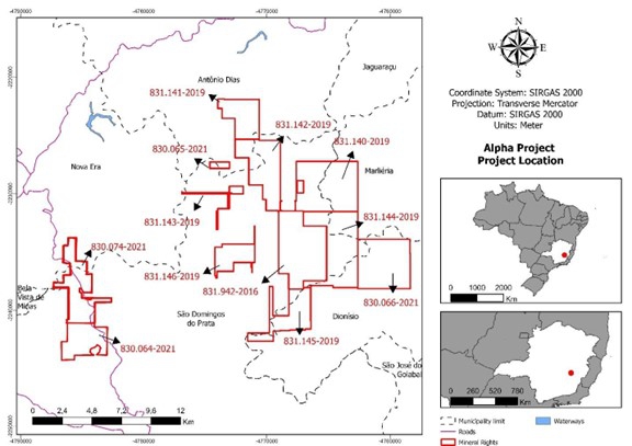
Figure 1: Map of the Alpha Project mineral rights.
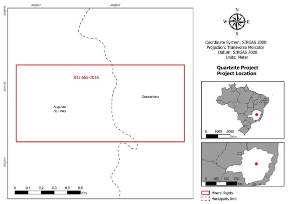
Figure 2: Map of the Quartzite Project mineral right.
Additional Information on Material Properties
Alpha Project
Infrastructure:
The Alpha Project’s primary mineral right (claim number ANM 831.942/2016) is located in the rural zone of Santana do Alfié, a district in the municipality of São Domingos do Prata, in the interior of the state of Minas Gerais in Brazil. According to the latest data from the Brazilian Institute of Geography and Statistics (“IBGE”), the population of Santana do Alfié was 1,691 inhabitants. We believe that the current population size is similar. Houses in this district have power from the electric grid and utilize wells for water.
The district of Santana do Alfié originated in 1751 as a settlement near locations where alluvial gold had been identified by the Portuguese settlers of Brazil. It is a local understanding that the word “Alfié” derives from the evolutionary phonetic contraction of the term “Ouro Fiel” which can be translated as “Faithful Gold”.
The municipality of São Domingos do Prata, the largest town near the Alpha Project, had 17,392 inhabitants according to the IBGE census of 2022. This town is located only a few miles from the Alpha Project mineral rights and serves as the logistical basis where geologists and consultants stay. São Domingos do Prata offers all of the basic infrastructure needs such as labor and supplies.
Belo Horizonte, the 6th largest city in Brazil with a population of 2,315,560 according to the IBGE census of 2022, is only 88 miles away from the Alpha Project mineral rights. The Company’s office is located in Belo Horizonte. Belo Horizonte is the capital of the Brazilian state called “Minas Gerais” which in translation means “General Mines”. According to data provided in January 2024 by the Sindicato da Indústria Mineral do Estado de Minas Gerais, an organization representing the Minas Gerais mining industry sector, the state of Minas Gerais is responsible for 41.5% of all mineral output of Brazil, placing it as the top mineral producing state among 27 states in Brazil. In fact, Belo Horizonte is commonly known as “the mining capital of Brazil” for having strong concentration of head offices of mining companies and extensive availability of labor and supplies. The Belo Horizonte metropolitan area is served by a modern airport (Aeroporto Internacional de Confins – symbol CNF) with regional and international flights, including non-stop flights to the U.S.
During visits to the site, it was possible to check the condition of the existing roads, which are generally in good condition and appear to be frequently maintained, due to agricultural and cattle ranching activity in the vicinity (Figure 3).
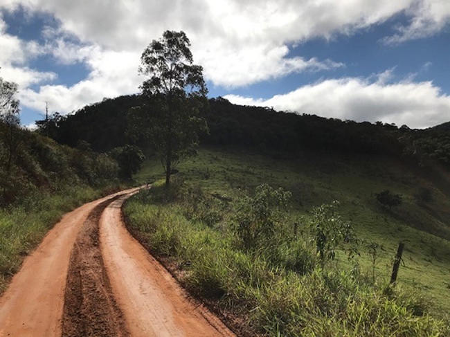
Figure 3: Local road used to access the Alpha Project showing good condition.
For use in mobile offices, workshops and other support structures during drilling campaigns, the network of the local utility company, already existing on site, will be used. To do this, it will be necessary to install a point on the distribution line to connect with the future unit.
The area near and within the Alpha Project is home to multiple small waterways. We expect to apply for and receive permits for local water usage to support drilling campaign operations.
Work Completed:
Prior Work
As prior owner of the mineral right ANM 831.942/2016 which currently belongs to Jupiter Gold, Mineração Ouro Fiel (the “Prior Owner”) identified gold targets from soil geochemistry and confirmed mineralization in the colluvium through auger holes. This research work was carried out using a regular mesh, sampling every meter and chemical analysis at an outside laboratory.
Surface Owner Authorization
As the Company owns the mineral right but not the surface, prior to carrying out any exploration work, proper authorization was obtained from the surface owner. Our relations with the surface owner are very good.
Trenching
In 2020 and 2021, Oxford Geoconsultants (“Oxford”), a technical consulting firm with a geologist that meets the Qualified Person definition of Regulation S-K 1300 performed geological studies, including new trenching, in targets within ANM 831.942/2016. A summary of such results is presented below.
The research work carried out by Oxford at the Alpha Project has included semi-detailed geological recognition and mapping, in addition to well resampling and chemical analysis.
The geological recognition of the area was carried out through walks that identified and registered 58 excavations consisting of wells and trenches, carried out by the Prior Owner. At a promising target denominated “Lavrinha”, regional geological reconnaissance was also carried out to identify the main lithotypes existing in the area, as well as collect structural data and mineral occurrences.
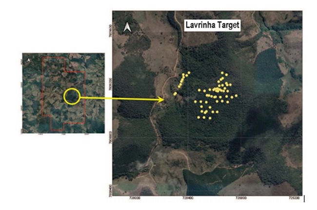
Figure 4: Location map of old excavations at the Lavrinha target.
After the geological recognition stage, 188 information collection points were registered, such as lithologies, predominant mineralogy of rock structures and the presence of structures and outcrops of interest, among other relevant geological information of the location, for the preparation of a map of the area on a scale of semi-detail, supported by the description of wells and trenches opened by the Prior Owner (Figure 4).
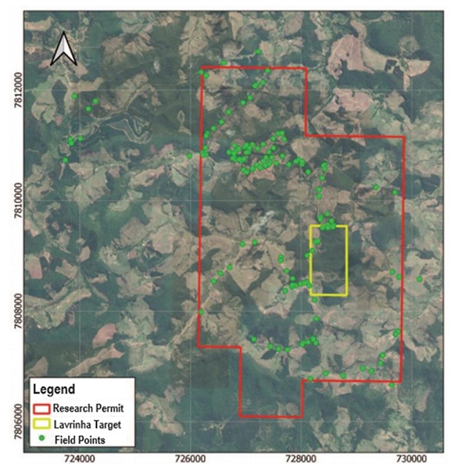
Figure 5: Field point map.
In the well resampling stage, two wells were chosen from the 58 existing excavations (Figure 5). Saprolite material and colluvial material were analyzed, resulting in 37 samples at intervals of 1 meter in 1 meter, through vertical channels on one of the faces (north face) of the wells. The samples were collected from the bottom to the wellhead, always in the center of the face, thus avoiding contamination of lower intervals by material from higher intervals. Information on lithology and structures was collected that can assist in the geological-structural understanding of gold mineralization (Figure 6). For each sample, 3 kg of material was collected. All collected material was placed in a properly identified and sealed sample bag, avoiding sample exchange, loss of material or contamination during transport and storage. Finally, the samples were sent for chemical analysis at the SGS Geosol laboratory (“SGS”), in Vespasiano, Minas Gerais, a highly regarded analytical laboratory used by all major mining companies in Brazil. After description and sampling, these wells remained open for future audits, surrounded by a wire fence to prevent accidents with people and/or animals.
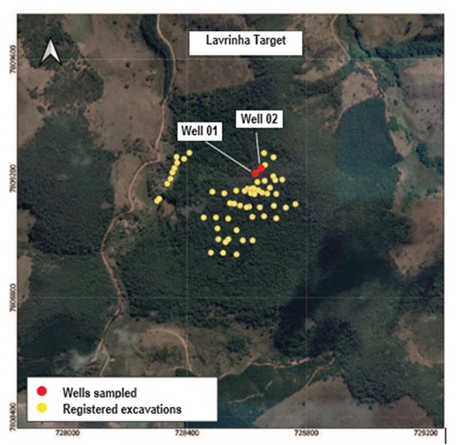
Figure 6: Map with location of sampled wells and registered excavations.
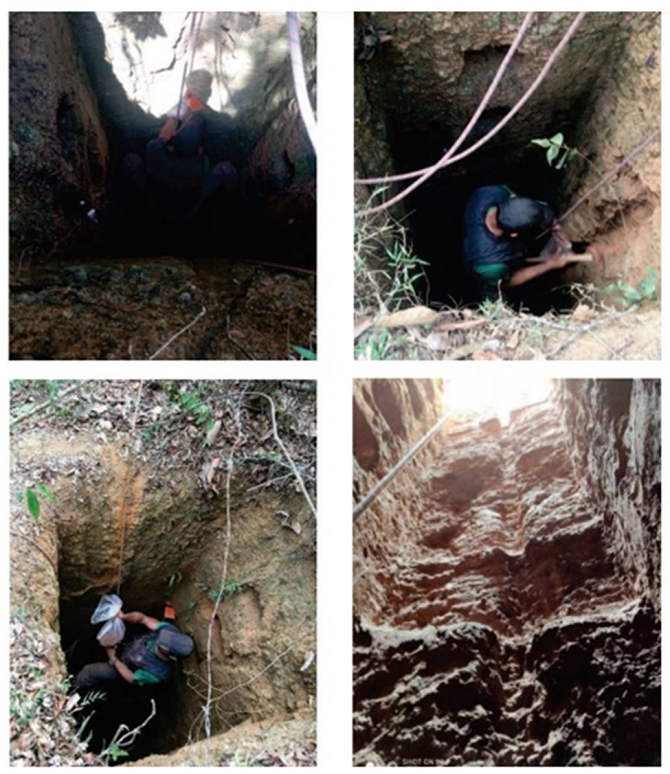
Figure 7: Photographs of the work performed in resampling of wells.
Chemical Analysis of Samples
In the chemical analysis stage, the fire assay method was used by SGS, resulting in the results presented in Table 1 below. Well 2 showed high levels in colluvium and saprolite with 4m at 5.0 gAu/t (simple average influenced by high content of sample AM36), a value of 0.70 gAu/t in the range of 7 to 8m depth, and additionally showed some anomalous values between 12 to 14m and 17 to 19m. The AM36 sample is noteworthy because it presented a gold content of 16,523 ppb; however it should be noted that the gold grain in the region is coarse, and a nugget effect may occur.
Table 1: Results of chemical analysis of samples from Wells 1 and 2.
| Well 1 | Well 2 | |||||||||||||
| Sample | From (m) | To (m) | Au content (ppb) | Sample | From (m) | To (m) | Au content (ppb) | |||||||
| AM17 | 0 | 1 | 264 | AM 37 | 0 | 1 | 38 | |||||||
| AM16 | 1 | 2 | 248 | AM 36 | 1 | 2 | 382 | |||||||
| AM15 | 2 | 3 | 335 | AM 35 | 2 | 3 | 262 | |||||||
| AM14 | 3 | 4 | 197 | AM 34 | 3 | 4 | 12 | |||||||
| AM13 | 4 | 5 | 473 | AM 33 | 4 | 5 | 71 | |||||||
| AM12 | 5 | 6 | 91 | AM 32 | 5 | 6 | 39 | |||||||
| AM11 | 6 | 7 | 400 | AM 31 | 6 | 7 | 110 | |||||||
| AM10 | 7 | 8 | 813 | AM 30 | 7 | 8 | 166 | |||||||
| AM09 | 8 | 9 | 26 | AM 29 | 8 | 9 | 84 | |||||||
| AM08 | 9 | 10 | 1,336 | AM 28 | 9 | 10 | 30 | |||||||
| AM07 | 10 | 11 | 319 | AM 27 | 10 | 11 | 18 | |||||||
| AM06 | 11 | 12 | 31 | AM 26 | 11 | 12 | 19 | |||||||
| AM05 | 12 | 13 | 15 | AM 25 | 12 | 13 | 724 | |||||||
| AM04 | 13 | 14 | 20 | AM 24 | 13 | 14 | 28 | |||||||
| AM03 | 14 | 15 | <5 | AM 23 | 14 | 15 | 89 | |||||||
| AM02 | 15 | 16 | 13 | AM 22 | 15 | 16 | 80 | |||||||
| AM01 | 16 | 17 | 17 | AM 21 | 16 | 17 | 376 | |||||||
| AM 20 | 17 | 18 | 1,214 | |||||||||||
| AM 19 | 18 | 19 | 16,523 | |||||||||||
| AM 18 | 19 | 20 | 2,161 | |||||||||||
Exploration Plan:
As of December 31, 2023, the Company has engaged a geologist who meets the “Qualified Person” criteria under Item 1300 of Regulation S-K to prepare an exploration plan for the Alpha Project. Planning and budgeting for such exploration plan described above is ongoing. The Company anticipates that its initial cost will be in the $250,000 to $350,000 range, and will encompass further detailed geological mapping, geophysics, and initial exploratory drill holes.
Book Value of Property:
The book value of the property is less than $10,000. It includes the cost of obtaining the mineral property directly from the Brazilian national mining department. The Company has title to the mineral rights of the Alpha Project, and such title has no known encumbrances and can be assumed to be more valuable than its book value, although no third-party offers have been received or estimates prepared.
Quartzite Project
Infrastructure:
Our Quartzite Quarry (thereafter, simply “Quarry”) is in the rural zone of Conselheiro Mata, a district in the municipality of Diamantina, in the interior of the state of Minas Gerais in Brazil. According to the latest data from the IBGE, the population of Conselheiro Mata was 819 inhabitants. Most houses in the rural zone of this district have power from the electric grid and utilize wells for water.
The municipality of Diamantina, the largest town near our Quarry, had 47,702 inhabitants according to the IBGE census of 2022. Diamantina offers all the basic infrastructure needs such as labor and supplies.
Belo Horizonte, the capital of the state of Minas Gerais and where the Company has its principal place of business, is 172 miles away from our Quarry. Belo Horizonte is commonly known as “the mining capital of Brazil” for having strong concentration of head offices of mining companies and extensive availability of labor and supplies. The Belo Horizonte metropolitan area is served by a modern airport (Aeroporto Internacional de Confins – symbol CNF) with regional and international flights, including non-stop flights to the U.S.
During visits to the site, it was possible to check the condition of the existing roads, which are generally in good condition and appear to be frequently maintained, due to agricultural and cattle ranching activity in the vicinity.
Work Completed:
Overview
Quartzite is a very hard rock composed predominantly of an interlocking mosaic of quartz crystals. Over the last several years, polished quartzite slabs have become sought after as a higher-end substitute to granite in kitchen countertops and tiles. Brazil has a flourishing quartzite mining industry centered in the neighboring the states of Minas Gerais and Espírito Santo with smaller producers being the norm. Each quarry produces quartzite of different color and texture and therefore stones are unique to their location. Mining is via simple open pit procedures, not particularly labor intensive, and with the mined product normally prepared as cubes of raw quartzite measuring ten meters in each diameter. Buyers are normally responsible for the logistics of transporting such raw quartzite blocks from the mine. Buyers for quartzite mined in Brazil are primarily from four locations: Brazil itself, United States, China, and Italy. It is common for mines to develop an exclusive selling relationship with a buyer.
While we are primarily focused on gold, in one of our mineral rights, ANM 831.665/2016 (the “Area”), measuring 94.44 hectares, a greenfield deposit of quartzite was identified by our exploration team which became our “Quartzite Project”.
In 2020, we studied the Quartzite Project with rotary drilling in which we obtained a preliminary volumetric estimate of four deposits of quartzite which had been identified in the Area. Such geological studies, drilling campaign, and volumetric estimates were not carried out under Item 1300 of Regulation S-K.
In 2021, Yan Taffner Binda, a mining engineer with vast experience in quartzite who meets the “Qualified Person” criteria under Item 1300 of Regulation S-K, prepared the mining plan for an open pit quarry at the Quartzite Project.
In 2021, Geoline, an independent engineering and environmental licensing consultancy, performed the field studies needed to file our petition to the applicable regulatory body for an operational license. The filing of such permit occurred in August 2021. On April 4, 2022, our Quartzite Project received the necessary permit from the Brazilian mining department (“ANM”). On December 12, 2022, our Quartzite Project received the operational license from the state of Minas Gerais environmental department (“SUPRAM”). These approvals from ANM and SUPRAM have allowed the Quartzite Project to begin its operations and to be able to commercialize production. As a result, we will refer to our Quartzite Project as the “Quartzite Quarry” or simply “Quarry”.
Preparation of the site for operations of the Quarry began in June 2023. The first quartzite block was retrieved on August 31, 2023. For the period between September 1, 2023, and December 31, 2023, a mining trial period, the Quarry team was comprised of one manager, one supervisor, and five mining workers. The processing was done by cutting the blocks with diamond wire. The blocks produced had dimensions varying between 6 m3 and 12 m3.
For the period between August 31, 2023, and December 31, 2023, a total of 223.10 cubic meters of quartzite blocks were produced and 80.82 cubic meters were sold to independent third parties from Brazil and Italy for an aggregate total revenue of R$ 531,580.39 (Brazilian reais) or approximately US$ 82,935.40. Thus, the average revenue per cubic meter of raw quartzite block sold was approximately US$ 1,026.
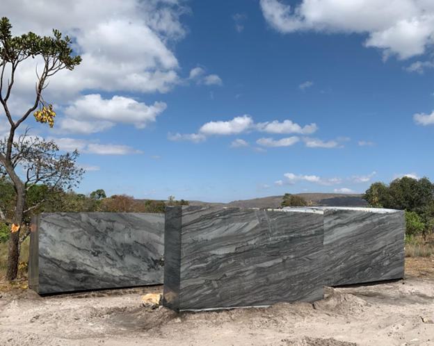
Figure 8: Example of blocks produced at our Quartzite Quarry in 2023
One block of quartzite was cut into slabs which were subsequently polished. It is expected that the revenue generated from sales of polished slabs on a per-cubic-meter basis will be three to four times that of raw quartzite blocks according to initial contacts with prospective buyers.
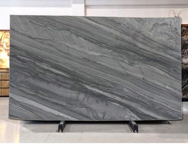
Figure 9: Polished quartzite slab from our Quartzite Quarry production
Specific Details
Surface Owner Authorization
As the Company owns the mineral right but not the surface, prior to carrying out any exploration work, proper authorization was obtained from the surface owner. Our relations with the surface owner are very good.
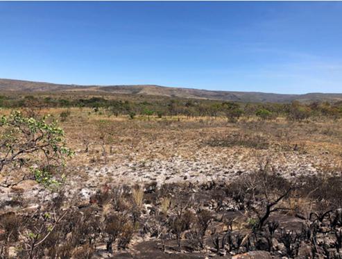
Figure 10: View of the Area.
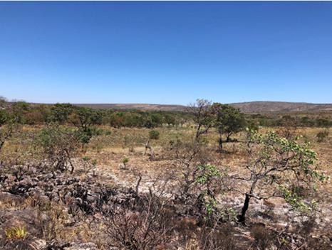
Figure 11: Another view of the Area.
Geological Mapping
Two days of mapping were carried out in the region, one on October 19, 2019, and another on September 10, 2020. The primary objective was to look for signs of gold, manganese, and/or quartzite mineralization in the Area.
The presence of manganese was a consideration given the existence of a deactivated manganese mine from Mineração Vale do Jacaré, a local mining company, approximately 2 km from the Area, as can be seen on the map below.
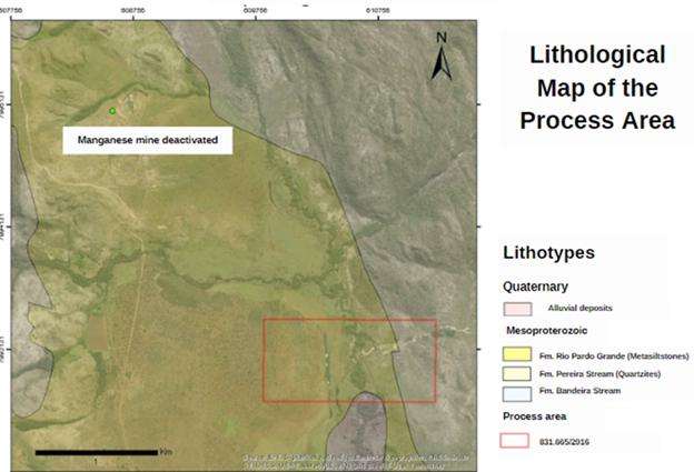
Figure 12: Lithological map of the Area and deactivated manganese mine nearby.
Quartzite outcrop formations in the Area were identified during geological mapping. The identified occurrences varied from white to medium gray, sometimes with levels parallel to stratification. White-appearing quartzites were apparent below grayish facies and were particularly observed in drainage channels.
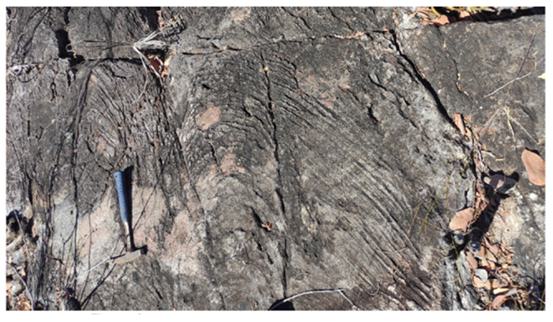
Figure 13: Image of grey quartzite outcrop in the Area.
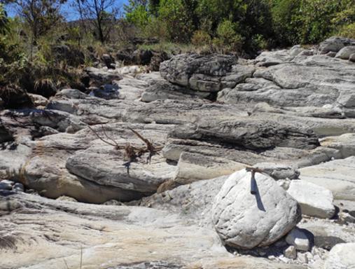
Figure 14: Foreground image of white quartzite outcrop in the Area.
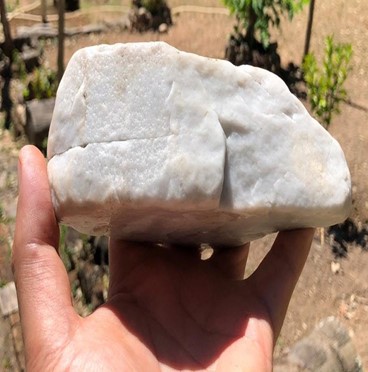
Figure 15: Detail of white quartzite sample from the Area.
Subsurface Sampling
Subsurface sampling was carried out by means of shallow detonations.
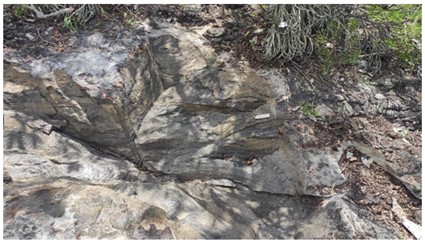
Figure 16: Subsurface sampling work in the Area.
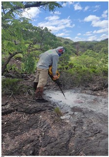
Figure 17: Subsurface sampling work in the Area.
Rotary Drilling
The geological exploration was carried out by means of rotary drilling by an independent consultant to 15 meters depth for subsurface recognition of the aesthetic characteristics of the rock identified in the previous stage of blasting sampling, such as basic color, mineralogical alternation due to stratification, presence of layered portions, veins and other characteristics that could be exposed, as they differ completely from the outcrop, susceptible to weathering.
The location of the five planned drill holes is shown in the map below (“FS” stands for “furo de sonda” which means drill hole). Drill holes 1 through 4 were executed, and are succinctly described below.
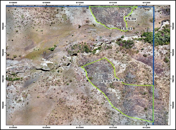
Figure 18: Map showing drill hole locations in the Area.
Drill Hole 1
The quartzite rock showed medium gray color with the presence of dark gray portions.
Weathered parts identified in the first 30 cm. From 6.1 m to 6.4 m, and also from 9.2 m to 9.6 m, sandy patches were seen. Two rusty parts were identified, one with 5 cm starting at 12.6 m and other with 8 cm starting at 13.0 m.
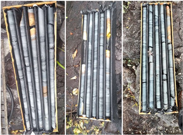
Figure 19: Cores obtained from drill hole 1 in the Area.
Drill Hole 2
The quartzite rock showed medium gray color with the presence of dark gray portions, with 74% of core recovery due to the drill rod being stuck at the bottom of the hole.
Rusty parts were identified in the first 60 cm, and also from 8.4 m to 8.9 m, and from 11.6 m to 12.1 m. The drill bit stuck caused an interruption in the planned drilling after this point.
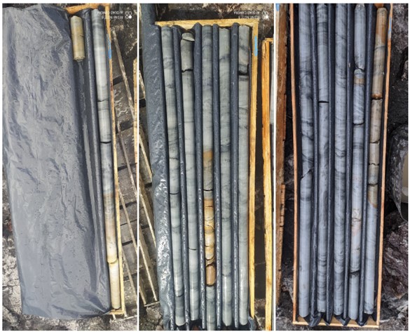
Figure 20: Cores obtained from drill hole 2 in the Area.
Drill Hole 3
The quartzite rock showed alternances of medium gray color with the presence of dark gray portions and yellowish medium gray parts until 4.6 m.
A sandy interval was dissolved in the drilling mud from 2.9 m to 3.2 m. From 4.6 m to 15 m the rock graded from medium to dark gray to light to medium gray portions indicating a possible second lighter material with strong market potential.
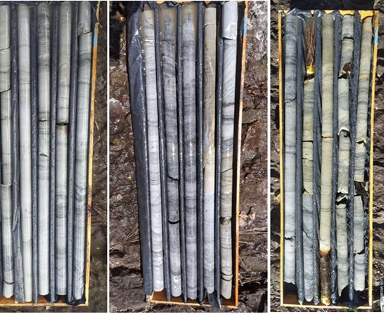
Figure 21: Cores obtained from drill hole 3 in the Area.
Drill Hole 4
The entire 15 m core was recovered showing alternances of medium gray with light to medium gray matrix with thin layers of dark gray. Some light yellowish weathered parts appeared in the first 5 m.
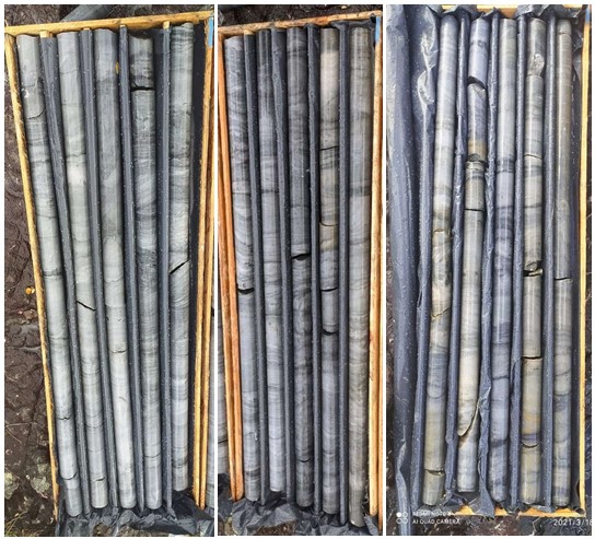
Figure 22: Cores obtained from drill hole 4 in the Area.
Aerial Survey
In order to ascertain the size of the quartzite outcrops with greater precision, an aerial survey was carried out using a drone. The flight was planned to prioritize the eastern portion of the Area and Litchi software was used, as can be seen in the figure below.
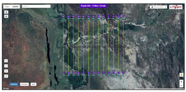
Figure 23: Aerial image showing flight plan made by drone.
In 2021, aerial photogrammetry and field survey of the eastern part of the Area was carried out by an outside consultant. This resulted in a planimetric map at scale 1:6,000 with contour lines at each meter and allowed a digital elevation model of the eastern part of the Area to be created.
The resulting map included all basic geographic information, such as drainages, accesses, and relevant physical structures, facilitating field work and serving as a basis for geological mapping of the area and delimitation of search targets for resource calculation. The map was created using ArcGIS 10.5 and Datamine Studio 3 software and RM for resource cubing.
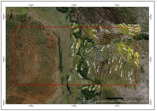
Figure 24: Topographic map from 2021 of the eastern portion of the Area.
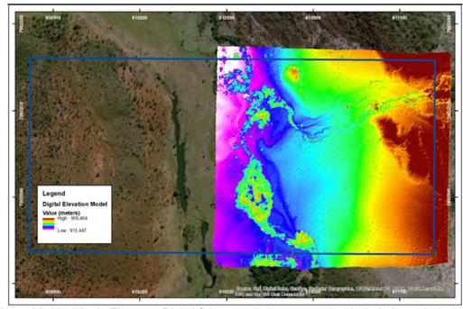
Figure 25: Digital elevation model of the Area made from contour lines.
Data processing also resulted in an orthoimage of the eastern portion of the Area. Agisoft software Metashape 1.6 was used for orthoimage processing. The orthoimage can be seen below.
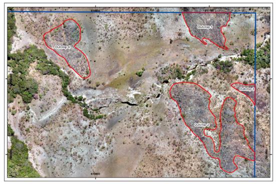
Figure 26: Orthoimage with delimitation of quartzite outcrops in the eastern region of the Area.
Surface Area Estimation
With the information provided by the orthoimage above, it was possible to estimate the surface area of the quartzite formations.
Estimation of Depth of Formations
Thickness estimates of quartzites in the region from various Brazilian geologists were consulted. Pflug (1968) suggests that common quartzite thickness in the region is between 700-1,000 meters. On the other hand, Schöll & Fogaça (1980) and Diniz & Pinheiro (1980) both suggest that such thickness is approximately 250 meters. In our estimation of thickness we used the more conservative figure, 250 meters.
Volume Estimation
Topography data extracted in GIS (System Information Geographic) were processed by the Datamine Studio 3 software, in order to obtain the geological model of quartzite massifs and their respective volumes.
The four rock masses delimited in the field stages were modeled. These four rocky bodies and their respective volume calculations are represented in the sequence of figures and table below.
| Quartzite Formations | Estimated Volume (m3) |
| Rocky Body 01 | 302,380 |
| Rocky Body 02 | 867,801 |
| Rocky Body 03 | 243,292 |
| Rocky Body 04 | 40,916 |
| TOTAL | 1,454,389 |
Table 1: Estimate of volume of quartzite formations in the Area.
Exploration Plan:
As of December 31, 2023, there is no plan for further geological exploration of the Area as the focus going forward will be on mining and revenue generation. The Company plans to continue to rely on the technical expertise of Yan Taffner Binda, a mining engineer with vast experience in quartzite who meets the “Qualified Person” criteria under Item 1300 of Regulation S-K.
As subsequent events after December 31, 2023, in 2024 we have retained two executives to work with our Quarry: a director of operations, and a director of sales and marketing.
The director of operations will focus on safely improving production to 100 m3 per month and then to 250 m3. This will likely require the addition of more equipment, and likely the hiring of additional workers.
The director of sales and marketing will focus on attempting to commercialize quartzite slabs obtained from our production to the U.S. market.
Planning and budgeting for the expansion described above is ongoing. The Company anticipates that it will need working capital of $150,000 to $200,000 to run the Quarry and its developing commercial operations.
Book Value of Property:
The book value of the property is less than $10,000. It includes the cost of obtaining the mineral property directly from the Brazilian national mining department. The Company has title to the Area, and such title has no known encumbrances and can be assumed to be more valuable than its book value, although no third-party offers have been received or estimates prepared.
Non-Material Properties
Summary of Non-Material Properties
| Project | Mineral Right Number | Area (hectares) | Mineral | Municipality | State, Country | |||||
| Alta Floresta Project | 867.176/2019 | 9,740.91 | gold | Peixoto de Azevedo | Mato Grosso, Brazil | |||||
| Alta Floresta Project | 867.173/2019 | 83.99 | gold | Terra Nova do Norte | Mato Grosso, Brazil | |||||
| Alta Floresta Project | 867.174/2019 | 47.55 | gold | Matupa, Nova Guarita | Mato Grosso, Brazil | |||||
| Apui Project | 880.133/2016 | 9,325.31 | gold | Apui | Amazonas, Brazil | |||||
| Apui Project | 880.134/2016 | 9,391.67 | gold | Apui | Amazonas, Brazil | |||||
| Apui Project | 880.135/2016 | 9,340.04 | gold | Apui | Amazonas, Brazil | |||||
| Brotas de Macauba Project | 870.400/2019 | 1,951.18 | gold, palladium, platinum | Brotas de Macauba | Bahia, Brazil | |||||
| Cavalcante Project | 860.479/2019 | 1,930.79 | gold | Parana (TO), Cavalcante (GO) | Goias and Tocantins, Brazil | |||||
| Crixas Project | 860.807/2016 | 1,241.63 | gold | Crixas, Uirapuru | Goias, Brazil | |||||
| Paracatu Project | 831.883/2016 | 312.66 | gold | Paracatu | Minas Gerais, Brazil |
Maps of Non-Material Properties
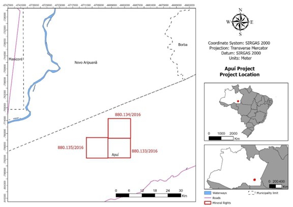
Figure 27: Map of the Alta Floresta Project.
Figure 28: Map of the Apui Project.
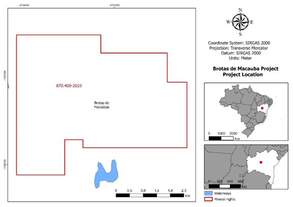
Figure 29: Map of the Brotas de Macauba Project.
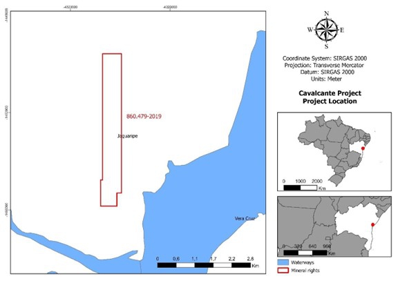
Figure 30: Map of the Cavalcante Project.
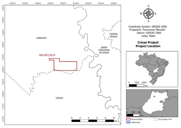
Figure 31: Map of the Crixas Project.
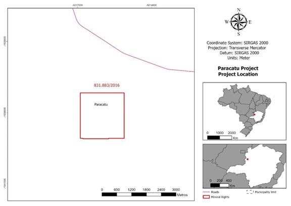
Figure 32: Map of the Paracatu Project.
We respectfully inform the Staff that we have not implemented formal exploration program internal controls to comply with Item 1305 of Regulation S-K, but we have engaged a qualified person for gold and a qualified person for quartzite, as such term is defined in Subpart 1300 of Regulation S-K, who works on both the Alpha Project and the Quartzite Project.
| 2. | We note your response to prior comment 2 stating that you “...will remove any disclosures that are not supportable pursuant to the requirements of Item 1302(a)(1) of Regulation SK,” although also indicating that if the information is retained you would clarify that it does not meet these requirements and is publicly available and consistent with reporting standards of the Brazilian national mining agency. |
We continue to believe that you will need to remove estimates of mineralization from your filing that do not meet the resource or reserve definitions in Item 1300 of Regulation S-K, and which you are unable to support in accordance with Item 1302(a)(1) of Regulation S-K. We reissue prior comment 2.
We respectfully inform the Staff that in our next Form 20-F for the fiscal year ended December 31, 2023, we will remove any disclosures that do not meet the resource or reserve definitions in Item 1300 of Regulation S-K, and which we are unable to support in accordance with Item 1302(a)(1) of Regulation S-K. In particular, the data available under the standards of the Brazilian national mining agency will be removed.
| 3. | We note your response to prior comment 4 stating that the gold bar illustration in your filing “is an example of a product” from your portable alluvial gold processing plant, although you have not provided any details regarding the timeframe or circumstances of its production or how it serves as an appropriate example. |
Unless you are able to show relevant correlation with your properties or services please remove the illustration to avoid misleading inferences.
However, if you believe that you are able to justify using the illustration in your filing, provide us with the relevant details and a draft of any clarifying disclosures that you propose to accompany the photograph. We reissue prior comment 4.
We respectfully inform the Staff that in our next Form 20-F for the fiscal year ended December 31, 2023, we will remove the photograph of the gold bar.
We inform the Staff that we plan to file the Form 20-F for fiscal year ended December 31, 2023 on or before March 8, 2024.
Very Truly Yours,
| /s/ Marc Fogassa | |
| Marc Fogassa | |
| Chairman & CEO | |
| Jupiter Gold Corporation |