

Exhibit 96.2
|
|
SK-1300 TECHNICAL REPORT SUMMARY
ON THE
MALACACHETA PROJECT,
MINAS GERAIS STATE, BRAZIL
Prepared for:
Atlas Critical Minerals Corporation (NASDAQ: JUPGF)
Rua Antônio de Albuquerque, 156, Suite 1720, Belo Horizonte,
Minas Gerais, Brazil, 30112-010
Report Date: July 31, 2025
Effective Date: August 13, 2025
Prepared by:
SGS Canada Inc.
SGS Project #19546-02

| S-K 1300 Technical Report – Malacacheta Graphite Project – Minas Gerais, Brazil | Page i |
TABLE OF CONTENTS
| TABLE OF CONTENTS | i | ||||
| LIST OF FIGURES | ii | ||||
| LIST OF TABLES | ii | ||||
| 1 | SUMMARY | 3 | |||
| 1.1 | Introduction | 3 | |||
| 1.2 | Property Description, Location, Access, and Physiography | 3 | |||
| 1.3 | History | 4 | |||
| 1.4 | Geology and Mineralization | 4 | |||
| 1.5 | Exploration | 5 | |||
| 1.6 | Data Verification | 5 | |||
| 1.7 | Mineral Processing and Metallurgical Testing | 5 | |||
| 1.8 | Mineral Resource Estimates | 5 | |||
| 1.9 | Adjacent Properties | 5 | |||
| 1.10 | Conclusions and Recommendations | 6 | |||
| 1.10.1 | Conclusions | 6 | |||
| 1.10.2 | Recommendations | 6 | |||
| 2 | INTRODUCTION | 7 | |||
| 2.1 | Registrant Information | 7 | |||
| 2.2 | Terms of Reference and Purpose | 7 | |||
| 2.3 | Sources of Information | 7 | |||
| 2.4 | Personal Inspection Summary | 8 | |||
| 2.5 | Previously Filed Technical Report Summary Report | 8 | |||
| 2.6 | Units and Abbreviations | 8 | |||
| 3 | PROPERTY DESCRIPTION | 10 | |||
| 3.1 | Property Description and Location | 10 | |||
| 3.2 | Mineral Tenure | 10 | |||
| 3.3 | Surface Rights | 12 | |||
| 3.4 | Royalties and Encumbrances | 12 | |||
| 3.5 | Reliance on Other Experts | 12 | |||
| 4 | ACCESSIBILITY, CLIMATE, LOCAL RESOURCES, INFRASTRUCTURE, AND PHYSIOGRAPHY | 13 | |||
| 4.1 | Accessibility | 13 | |||
| 4.2 | Climate | 13 | |||
| 4.3 | Local Resources | 13 | |||
| 4.4 | Infrastructure | 13 | |||
| 4.5 | Physiography | 13 | |||
| 5 | HISTORY | 14 | |||
| 5.1 | Historical Resource Estimates | 14 | |||
| 5.2 | Past Production | 14 | |||
| 6 | GEOLOGICAL SETTING, MINERALIZATION, AND DEPOSIT | 15 | |||
| 6.1 | Regional Geology | 15 | |||
| 6.2 | Local and Property Geology | 17 | |||
| 6.3 | Deposit Type | 19 | |||
| 7 | EXPLORATION | 20 | |||
| 7.1 | Surface Sampling | 20 | |||
| 7.2 | Auger Drilling | 23 | |||
| 8 | SAMPLE PREPARATION, ANALYSES, AND SECURITY | 25 | |||
| 9 | DATA VERIFICATION | 26 | |||
| 10 | MINERAL PROCESSING AND METALLURGICAL TESTING | 27 | |||
| 10.1 | Scope | 27 | |||
| 10.2 | Methods of Chemical Analysis | 27 | |||
| 10.3 | Flotation | 28 | |||
| 10.4 | Sample Receiving | 29 | |||
| 10.5 | Chemical Analysis of The Original Samples | 29 | |||
| 10.6 | Flotation Results | 31 | |||
| 10.7 | Size by Size Analysis | 32 | |||
| 10.8 | Results and Conclusion | 33 | |||
| 10.9 | Suggestion For Further Work | 34 | |||

| S-K 1300 Technical Report – Malacacheta Graphite Project – Minas Gerais, Brazil | Page ii |
| 11 | MINERAL RESOURCE ESTIMATES | 35 | |
| 12 | MINERAL RESERVE ESTIMATES | 36 | |
| 13 | MINING METHODS | 37 | |
| 14 | PROCESSING AND RECOVERY METHODS | 38 | |
| 15 | INFRASTRUCTURE | 39 | |
| 16 | MARKET STUDIES | 40 | |
| 17 | ENVIRONMENTAL STUDIES, PERMITTING, AND PLANS, NEGOTIATIONS, OR AGREEMENTS WITH LOCAL INDIVIDUALS OR GROUPS | 41 | |
| 18 | CAPITAL AND OPERATING COSTS | 42 | |
| 19 | ECONOMIC ANALYSIS | 43 | |
| 20 | ADJACENT PROPERTIES | 44 | |
| 21 | OTHER RELEVANT DATA AND INFORMATION | 45 | |
| 22 | INTERPRETATION AND CONCLUSIONS | 46 | |
| 23 | RECOMMENDATIONS | 47 | |
| 24 | REFERENCES | 48 | |
| 25 | RELIANCE ON INFORMATION PROVIDED BY THE REGISTRANT | 49 |
LIST OF FIGURES
| Figure 3-1 | Location of the Malacacheta Project | 10 | |
| Figure 3-2 | Malacacheta Property Map | 11 | |
| Figure 6-1 | Geological Map of the Araçuaí Orogen | 16 | |
| Figure 6-2 | Simplified Geology of the Macaúbas Group (Pedrosa-Soares et al., 2007) | 18 | |
| Figure 6-3 | Local Geology of the Malacacheta Project | 19 | |
| Figure 7-1 | Surface Samples from 2023 Exploration Campaign | 21 | |
| Figure 7-2 | Surface Samples from 2024 Exploration Campaign | 21 | |
| Figure 7-3 | Outcrop of Graphitic Mica Schist with Intercalated Gneiss Layers | 22 | |
| Figure 7-4 | Outcrop of Graphitic Mica Schist with Flake Graphite | 22 | |
| Figure 7-5 | Flake Graphite and Graphitic Schist Outcrop | 23 | |
| Figure 7-6 | Location of Auger Holes in Tenement 831.698/2021 | 24 | |
| Figure 10-1 | Test Work Flowsheet for Graphite Samples | 27 | |
| Figure 10-2 | Flotation Test Work Flowsheet | 28 |
LIST OF TABLES
| Table 1-1 | Final Size Intervals and Grades for Flotation Test Work | 5 | |
| Table 2-1 | List of Abbreviations | 9 | |
| Table 3-1 | Malacacheta Mineral Rights Description | 11 | |
| Table 7-1 | Assay Results from 2023 Auger Drilling Campaign | 24 | |
| Table 10-1 | Sample Identification and Weight | 29 | |
| Table 10-2 | Analysis Results for LECO, XRF and LOI | 30 | |
| Table 10-3 | Analysis Results for PHY00D on Ashes | 30 | |
| Table 10-4 | Flotation Results for SMAL-00001 | 31 | |
| Table 10-5 | Flotation Results for SMAL-00009 | 32 | |
| Table 10-6 | Flotation Concentrate for SMAL-00001 | 32 | |
| Table 10-7 | Flotation Concentrate for SMAL-00009 | 33 | |
| Table 10-8 | Final Size Intervals and Grades for Flotation Test Work | 33 |
| S-K 1300 Technical Report – Malacacheta Graphite Project – Minas Gerais, Brazil | Page 3 |
| 1 | SUMMARY |
SGS was engaged by Atlas Critical Minerals Corporation (OTCQB: JUPGF, “Atlas Critical Minerals”) for the preparation of an independent Technical Report Summary (“TRS”) on the Malacacheta Graphite Project, located in the municipality of Malacacheta, Minas Gerais, Brazil. The purpose of this Technical Report is to support the disclosure of the Malacacheta Exploration Results.
This TRS presents the results of the Property of Merit of the Malacacheta Project (“Malacacheta”). completed for Atlas Critical Minerals Malacacheta Project and is the first TRS for the Project filed with the United States Securities and Exchange Commission (SEC).
The scope of the TRS is to complete a Property of Merit report on the Malacacheta Project.
The Malacacheta Project is located in the northeast region of the Minas Gerais state, Brazil, near the city of Malacacheta, approximately 435 km by road from Belo Horizonte. The property is located approximately 9 km northwest of the city of Malacacheta.
The project is in UTM zone 23S and is located at approximately 804,577 m E and 8,032,489 m N.
Atlas Critical Minerals owns two mineral rights in the municipality of Malacacheta covering a total of 1,258 ha. Atlas Critical Minerals initiated geological reconnaissance of the property in 2023, which included detailed geological mapping, outcrop sampling and an auger sampling program.
| 1.1 | Introduction |
This TRS was prepared at the request of Atlas Critical Minerals Corporation, with its principal place of business at Rua Antônio de Albuquerque, 156, Suite 1720, Belo Horizonte, Minas Gerais, Brazil, 30112-010.
Atlas Critical Minerals is a critical minerals exploration company engaged in the exploration of graphite and rare earth elements (REEs) in Brazil.
Currently, Atlas Critical Minerals Corporation common stock is quoted for trading on the OTCQB operated by the OTC Markets Group, Inc. under the symbol “JUPGF.” Atlas Critical Minerals has applied for listing of their common stock on the Nasdaq Capital Market under the symbol “ATCX.”
This TRS conforms to the United States Securities and Exchange Commission’s (SEC) Modernized Property Disclosure Requirements for Mining Registrants as described in Subpart 229.1300 of Regulation S-K, Disclosure by Registrants Engaged in Mining Operations (S-K 1300) and Item 601 (b)(96) Technical Report Summary.
| 1.2 | Property Description, Location, Access, and Physiography |
The Malacacheta Project is located in northeast Minas Gerais State, about 435 km by road from Belo Horizonte. The property is located approximately 9 km northwest of the city of Malacacheta.
The climate in the Project area is classified as tropical savanna (Aw) according with the Köppen classification (Köppen, 1936). This climate type is known for having a distinct wet and dry season, while temperatures remain warm to hot year-round.
Malacacheta is predominantly an agricultural centre, with limited availability for basic services.
Analytical and drilling services would be contracted in the metropolitan region of Belo Horizonte. Skilled and semi-skilled labor is available in the region to support exploration activities.
| S-K 1300 Technical Report – Malacacheta Graphite Project – Minas Gerais, Brazil | Page 4 |
There is limited local infrastructure in proximity to the project. The Irapé Hydroelectric Power Plant is approximately 120km northwest of the property, which could provide power for the project. There is a network of mostly unpaved roads joining the property to local towns.
| 1.3 | History |
The project area has been included in some regional mapping campaigns, but there is no record of historical exploration in the area. However, there is evidence of historical artisanal mining in the form of small galleries excavated in pegmatite outcrops containing occurrences of citrine, alexandrite and large muscovite sheets.
| 1.4 | Geology and Mineralization |
The South American Platform is composed of Archean and Proterozoic metamorphic and igneous complexes, forming the continental core of South America (Almeida, 1984). Its consolidation occurred between the late Proterozoic and early Paleozoic, during the Brasiliano/Pan-African Orogenic Cycle (Trompette, 1994). This platform comprises three main shield areas, represented by cratons and Neoproterozoic fold belts: the Guiana Shield, the Central Brazil Shield, and the Atlantic Shield. The latter includes the São Francisco Craton and its surrounding belts (Almeida, 1984). The Araçuaí Belt borders the São Francisco Craton to the east and is part of the system of mobile belts associated with the amalgamation of the Gondwana supercontinent (Pedrosa-Soares and Wiedmann, 2000).
The evolution of the Araçuaí Orogen began with the opening of the Macaúbas Basin (~880 Ma) in an advanced continental rift setting, possibly forming a confined oceanic basin with limited development of oceanic crust. During this stage, the Capelinha and Chapada Acauã units were deposited. The closure of the basin led to the collision between the São Francisco and Congo cratons (~580 Ma), causing deformation and metamorphism of the entire Macaúbas Group sequence, including glacial units (Chapada Acauã) and volcano-sedimentary units (Ribeirão da Folha). Following the collision, orogenic collapse occurred, accompanied by the deposition of the Salinas Formation in post-collisional basins (Pedrosa-Soares et al., 2007).
The basement of the Araçuaí Orogen is composed of Archean and Paleoproterozoic complexes such as Guanhães, Gouveia, Porteirinha, Mantiqueira, Juiz de Fora, and Pocrane, all reworked during the Brasiliano orogeny. These complexes include TTG gneisses, migmatites, and granitoids, with isotopic signatures indicating ancient crustal sources. In the western portion of the orogen, the Espinhaço Supergroup crops out, comprising rift-related sequences that were deformed during the Brasiliano event (Noce et al., 2007; Degler et al., 2018).
The Macaúbas Group records the evolution of a Neoproterozoic basin that transitioned from a continental rift to a passive margin, with incipient oceanic crust formation, interpreted from tectonic ophiolites, plagiogranites, and records from the Ribeirão da Folha Formation. It is subdivided into pre-glacial, glacial, and post-glacial successions. The Capelinha Formation (pre-glacial) comprises graphitic metapelites associated with quartzites and amphibolites. The Ribeirão da Folha Formation (post-glacial) includes graphitic schists interlayered with turbidites and calcsilicate rocks in the western portion, and an ophiolitic sequence with graphite in metasedimentary rocks in the eastern portion (Pedrosa-Soares et al., 2007; Castro, 2014; Queiroga et al., 2007).
The mineralization at the Malacacheta project is classified as a flake graphite occurrence.
Flake graphite deposits are formed in regional metamorphic sequences ranging from upper amphibolite to granulite grade, coeval with peak metamorphism, and may also be found in the same districts as vein deposits. Texturally, flake graphite deposits vary from disseminations to high-grade (> 50 wt.%) concentrations in pods or lenses that are typically focused along lithologic contacts and within fold hinges.
| S-K 1300 Technical Report – Malacacheta Graphite Project – Minas Gerais, Brazil | Page 5 |
| 1.5 | Exploration |
Initial exploration started in 2023, and Atlas Critical Minerals identified surface outcrops with visible graphite, delineated mineralized bodies, and established a primary structural trend. Rock samples were collected (nine samples), and preliminary auger core drilling was conducted (21 drill holes), providing strong indications of the project’s potential.
Further exploration was undertaken in 2024, which expanded the understanding of the Malacacheta Project’s mineral potential. Atlas Critical Minerals systematically mapped and described 43 new points, paying close attention to surface exposures. A comprehensive sampling program was completed, with 17 samples of graphite schist and mica-schist with graphite collected from the two exploration permit areas.
Atlas Critical Minerals identified significant graphite schist bodies within both exploration areas, intercalated as lenses within mica schist. The tenement 830.954/2021 stands out as the most promising, with two highly prospective occurrences observed, mapped and sampled.
| 1.6 | Data Verification |
No property inspection has been completed at this time.
| 1.7 | Mineral Processing and Metallurgical Testing |
In 2025 Atlas submitted nine samples collected at the property to SGS Geosol in Belo Horizonte, Brazil for test work and flotation tests.
The results summarized in Table 1-1 indicate that the two samples used for flotation test work achieved grades between 91.3% and 97.7% graphitic carbon.
Using conventional flotation, grinding and attrition techniques, the final graphite concentrates achieved grades of 91.9% and 96.5% total graphite carbon, demonstrating the amenability of the Malacacheta Project to flotation.
Table 1-1 Final Size Intervals and Grades for Flotation Test Work
Size Interval (µm) |
C-Graph (%) SMAL-00001 |
C-Graph (%) SMAL-00009 | ||
| +300 | 93.0 | - | ||
| -300+180 | 96.6 | 93.8 | ||
| -180+150 | 94.5 | 95.3 | ||
| -150+75 | 93.1 | 97.7 | ||
| -75 | 91.3 | 93.0 | ||
| CONC CLN V EXP | 91.9 | 96.5 |
| 1.8 | Mineral Resource Estimates |
There are no Mineral Resource Estimates on this Project.
| 1.9 | Adjacent Properties |
There is no information on properties adjacent to the Project necessary to make the TRS understandable and not misleading.
| S-K 1300 Technical Report – Malacacheta Graphite Project – Minas Gerais, Brazil | Page 6 |
| 1.10 | Conclusions and Recommendations |
| 1.10.1 | Conclusions |
SGS Geological Services Inc. (“SGS”) was contracted by Atlas Critical Minerals Corporation (“Atlas Critical Minerals” or the “Company”) to complete a Property of Merit for the Malacacheta Graphite Project near the city of Teófilo Otoni, Brazil, and to prepare a Public Report in accordance with the §§ 229.601(b)(96) Technical report (subpart 229.1300 of Regulation S-K) written in support of a Property of Merit on the Malacacheta Project.
This TRS conforms to the United States Securities and Exchange Commission’s (SEC) Modernized Property Disclosure Requirements for Mining Registrants as described in Subpart 229.1300 of Regulation S-K, Disclosure by Registrants Engaged in Mining Operations (S-K 1300) and Item 601 (b)(96) Technical Report Summary.
Initial exploration started in 2023, and Atlas Critical Minerals identified surface outcrops with visible graphite, delineated mineralized bodies, and established a primary structural trend. Rock samples were collected (nine samples), and preliminary auger core drilling was conducted (21 drill holes), providing strong indications of the project’s potential.
Further exploration was undertaken in 2024, which expanded the understanding of the Malacacheta Project’s mineral potential. Atlas Critical Minerals systematically mapped and described 43 new points, paying close attention to surface exposures and sub-surface features. A comprehensive sampling program was completed, with 17 samples of graphite schist and mica-schist with graphite collected from the two exploration permit areas.
| 1.10.2 | Recommendations |
Atlas Critical Minerals identified significant graphite schist bodies within both exploration areas, intercalated as lenses within mica schist. The tenement 830.954/2021 stands out as the most promising, with two highly prospective occurrences observed, mapped and sampled
Atlas have defined further exploration work across the property, as detailed below. The QP recommends that Atlas proceed with these exploration programs.
| ● | A Geophysical Magnetometric Survey (Drone MAG), Aerophotogrammetry, and detailed topographic surveying using Lidar, with a budget of US$ 75,000.00. | |
| ● | Detailed fieldwork, including the collection of samples for chemical analysis to support high-resolution geological mapping, to be carried out by Atlas Critical Minerals’s team of geologists, with a budget of US$ 85,000.00. | |
| ● | In addition, the program will include a 5,000-meter drilling campaign, supported by the implementation of all necessary infrastructure for a complete sample management and quality control chain. This will encompass chemical analyses, proper sample storage in a dedicated facility, and the application of rigorous QA/QC protocols. The estimated budget for this phase is US$1,550,000.00 | |
| ● | The Atlas team will be responsible for managing and supervising field activities, with a budget of US$ 160,000.00. | |
| ● | Metallurgical Testing and SK-1,300 resource report with US$ 170,000.00. | |
| ● | Contingency US$ 105,000.00. | |
| ● | The total value of expenditures for the exploration program is US$ 2,145,000.00 for the resource report definition of both areas. |
| S-K 1300 Technical Report – Malacacheta Graphite Project – Minas Gerais, Brazil | Page 7 |
| 2 | INTRODUCTION |
SGS was engaged by Atlas Critical Minerals Corporation (OTCQB: JUPGF, “Atlas Critical Minerals”) for the preparation of an independent Technical Report Summary (“TRS”) on the Malacacheta Graphite Project, located in the municipality of Malacacheta, Minas Gerais, Brazil.
This TRS presents the results of the Property of Merit of the Malacacheta Project (“Malacacheta”). completed for Atlas Critical Minerals Malacacheta Project and is the first TRS for the Project filed with the United States Securities and Exchange Commission (SEC).
The scope of the TRS is to complete a Property of Merit report on the Malacacheta Project.
The Malacacheta Project is located in the northeast region of the Minas Gerais state, Brazil, near the city of Malacacheta, approximately 435 km by road from Belo Horizonte. The property is located approximately 9 km northwest of the city of Malacacheta.
The project is in UTM zone 23S and is located at approximately 804,577 m E and 8,032,489 m N.
Atlas Critical Minerals owns two mineral rights in the municipality of Malacacheta covering a total of 1,258 ha. Atlas Critical Minerals initiated geological reconnaissance of the property in 2023, which included detailed geological mapping, outcrop sampling and an auger sampling program.
| 2.1 | Registrant Information |
This TRS was prepared at the request of Atlas Critical Minerals Corporation (formerly Jupiter Gold Corporation), with its principal place of business at Rua Antônio de Albuquerque, 156, Suite 1720, Belo Horizonte, Minas Gerais, Brazil, 30112-010.
Atlas Critical Minerals is a diversified mining company with significant mineral rights in rare earths elements (REEs), titanium, natural graphite, uranium, copper, nickel, iron ore, quartzite, and gold in Brazil.
Currently, Atlas Critical Minerals Corporation common stock is quoted for trading on the OTCQB operated by the OTC Markets Group, Inc. under the symbol “JUPGF.” Atlas Critical Minerals has applied for listing of their common stock on the Nasdaq Capital Market under the symbol “ATCX.”
| 2.2 | Terms of Reference and Purpose |
SGS Geological Services Inc. (“SGS”) was contracted by Atlas Critical Minerals Corporation (“Atlas Critical Minerals” or the “Company”) to complete a Property of Merit for the Malacacheta Graphite Project near the city of Teófilo Otoni, Brazil, and to prepare a Public Report in accordance with the §§ 229.601(b)(96) Technical report (subpart 229.1300 of Regulation S-K) written in support of a Property of Merit on the Malacacheta Project.
This TRS conforms to the United States Securities and Exchange Commission’s (SEC) Modernized Property Disclosure Requirements for Mining Registrants as described in Subpart 229.1300 of Regulation S-K, Disclosure by Registrants Engaged in Mining Operations (S-K 1300) and Item 601 (b)(96) Technical Report Summary.
The purpose of this Technical Report is to support the disclosure of the Malacacheta Exploration Results.
| 2.3 | Sources of Information |
SGS Canada Inc. (“SGS”) was commissioned by Atlas Critical Minerals to prepare this TRS. In preparing this report, SGS relied upon input from Atlas Critical Minerals.
| S-K 1300 Technical Report – Malacacheta Graphite Project – Minas Gerais, Brazil | Page 8 |
Section 24 includes the reference documents that are part of the sources of information used in the preparation of this TRS.
SGS is an independent company and is not associate or affiliate of Atlas Critical Minerals or any associated company of Atlas Critical Minerals.
This TRS was prepared by SGS, and communication with Atlas Critical Minerals sources was conducted through the following list of personnel:
| ● | Eduardo Queiroz, Mariella Catarino, and Lucas Roux - Consultants | |
| ● | Igor Tkachenko - Advisor |
| 2.4 | Personal Inspection Summary |
No property inspection has been completed at this time.
| 2.5 | Previously Filed Technical Report Summary Report |
There have been no previous reports filed on this property.
| 2.6 | Units and Abbreviations |
All units of measurement used in this technical report are International System of Units (SI) or metric, except for Imperial units that are commonly used in industry (e.g., ounces (oz.) and pounds (lb.) for the mass of precious and base metals). All currency is in US dollars, unless otherwise noted. Frequently used abbreviations and acronyms can be found in Table 2-1.
| S-K 1300 Technical Report – Malacacheta Graphite Project – Minas Gerais, Brazil | Page 9 |
Table 2-1 List of Abbreviations
| $ | Dollar sign | m | Metres | |
| % | Percent sign | m2 | Square meters | |
| ° | Degree | m3 | Cubic meters | |
| °C | Degree Celsius | masl | Metres above sea level | |
| °F | Degree Fahrenheit | mm | millimeter | |
| µm | micron | mm2 | square millimeter | |
| AA | Atomic absorption | mm3 | cubic millimeter | |
| Au | Gold | Moz | Million troy ounces | |
| Az | Azimuth | MRE | Mineral Resource Estimate | |
| $CAD | Canadian dollar | Mt | Million tonnes | |
| cm | centimeter | mtph | Metric Tonnes per Hour | |
| cm2 | square centimeter | N | North | |
| cm3 | cubic centimeter | NAD 83 | North American Datum of 1983 | |
| C | Carbon | Ni | Nickel | |
| Co | Cobalt | NQ | Drill core size (4.8 cm in diameter) | |
| DDH | Diamond drill hole | OES | Optical emission spectroscopy | |
| E | East | ppm | Parts per million | |
| ft | Feet | QA | Quality Assurance | |
| ft2 | Square feet | QC | Quality Control | |
| ft3 | Cubic feet | QP | Qualified Person | |
| g | Grams | RC | Reverse circulation drilling | |
| GPS | Global Positioning System | RQD | Rock quality description | |
| Ha | Hectares | SG | Specific Gravity | |
| HQ | Drill core size (6.3 cm in diameter) | Ton | Short Ton | |
| ICP | Induced coupled plasma | Tonnes or T | Metric tonnes | |
| kg | Kilograms | $US | US Dollar | |
| km | Kilometers | UTM | Universal Transverse Mercator | |
| km2 | Square kilometer |
| S-K 1300 Technical Report – Malacacheta Graphite Project – Minas Gerais, Brazil | Page 10 |
| 3 | PROPERTY DESCRIPTION |
| 3.1 | Property Description and Location |
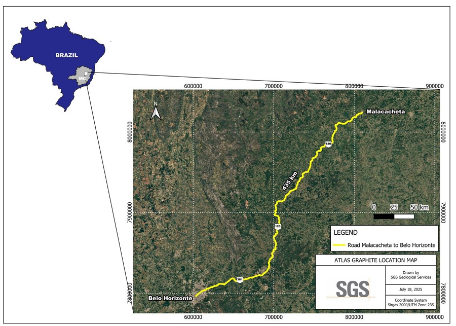
The Malacacheta Project is located in the northeast region of the Minas Gerais state, Brazil, near the city of Malacacheta, approximately 435 km by road from Belo Horizonte. The property is located approximately 9 km northwest of the city of Malacacheta.
The project is in UTM zone 23S and is located at approximately 804,577 m E and 8,032,489 m N.
Figure 3-1 shows the location of the project.
Figure 3-1 Location of the Malacacheta Project
| 3.2 | Mineral Tenure |
The legal framework for the development and use of mineral resources in Brazil was established by the Brazilian Federal Constitution, which was enacted on October 5, 1988 (the Brazilian Constitution) and the Brazilian mining code, which was enacted on January 29, 1940 (Decree-law 1985/40, later modified by Decree-law 227, of February 29, 1967, the Brazilian Mining Code).
According to the Brazilian Constitution, all mineral resources in Brazil are the property of the Federal Government. The Brazilian Constitution also guarantees mining companies the full property of the mineral products that are mined under their respective concessions. Mineral rights come under the jurisdiction of the Federal Government and mining legislation is enacted at the Federal level only. To apply for and acquire mineral rights, a company must be incorporated under Brazilian law, have its management domiciled within Brazil, and its head office and administration in Brazil.
| S-K 1300 Technical Report – Malacacheta Graphite Project – Minas Gerais, Brazil | Page 11 |
In general, there are no restrictions on foreign investment in the Brazilian mining industry, except for mining companies that operate, or hold mineral rights within a 150 km-wide strip of land parallel to the Brazilian terrestrial borders. In this instance the equity interests of such companies have to be majority Brazilian-owned. Exploration and mining activities in the border zone are regulated by the Brazilian Mining Code and supporting legislation.
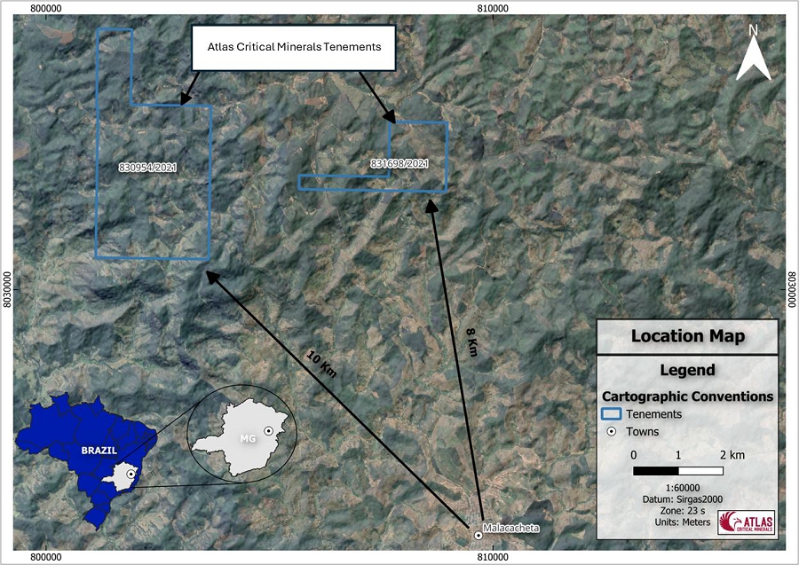
The Malacacheta project consists of two exploration permits covering an area of 1,258.2 ha. The tenement holdings are summarised in Table 3-1 and the location is shown in Figure 3-2.
Table 3-1 Malacacheta Mineral Rights Description
| Tenement | Year Granted | Area (Ha) | Phase | |||
| 831.698/2021 | 2021 | 260.95 | Exploration Permit | |||
| 830.954/2021 | 2021 | 997.28 | Exploration Permit |
Figure 3-2 Malacacheta Property Map
| S-K 1300 Technical Report – Malacacheta Graphite Project – Minas Gerais, Brazil | Page 12 |
| 3.3 | Surface Rights |
Under Brazilian law, foreign companies may acquire surface rights as long as the share capital is controlled by Brazilians. However, the holder of an exploration license is guaranteed by law access to conduct exploration field work, provided that adequate compensation is paid to third-party landowners, and that the holder of the exploration license assumes all environmental responsibilities arising from the exploration work.
After the exploration license is granted by the Brazilian government, Atlas Critical Minerals negotiates and obtains the necessary authorizations for access to the properties for research and exploration activities, with the exercise of mining activity guaranteed by the Brazilian Federal Constitution.
Atlas Critical Minerals is responsible for the reclamation of areas used for drilling, safety of personnel in the work area, monetary compensation to the landowner for surface damage caused by mineral exploration activities, and all environmental liabilities resultant from exploration activities.
| 3.4 | Royalties and Encumbrances |
Atlas Critical Minerals reports that there are no liens and encumbrances associated with the property.
| 3.5 | Reliance on Other Experts |
The QP has not reviewed the mineral tenure, nor independently verified the legal status, ownership of the Project area, underlying property agreements or permits. The QP has fully relied upon, and disclaims responsibility for, information supplied to them by Atlas Critical Minerals.
| S-K 1300 Technical Report – Malacacheta Graphite Project – Minas Gerais, Brazil | Page 13 |
| 4 | ACCESSIBILITY, CLIMATE, LOCAL RESOURCES, INFRASTRUCTURE, AND PHYSIOGRAPHY |
| 4.1 | Accessibility |
The Malacacheta Project is located in northeast Minas Gerais State, about 435 km by road from Belo Horizonte. The property is located approximately 9km northwest of the city of Malacacheta.
| 4.2 | Climate |
The climate in the Project area is classified as tropical savanna (Aw) according with the Köppen classification (Köppen, 1936). This climate type is known for having a distinct wet and dry season, while temperatures remain warm to hot year-round.
The daily average high ranges from 24°C (July) to 30°C (January), while the average daily low ranges from 13°C (July) to 20°C (February).
Malacacheta has a distinct wet and dry season and usually has the most precipitation in February, November and December, with an average of 17 rainy days and 193 mm of precipitation per month. The driest months in Malacacheta are June, July and September. On average, 18 mm of precipitation falls during these months.
Exploration work can be carried out year-round.
| 4.3 | Local Resources |
Malacacheta is predominantly an agricultural centre, with limited availability for basic services.
Analytical and drilling services would be contracted in the metropolitan region of Belo Horizonte. Skilled and semi-skilled labor is available in the region to support exploration activities.
| 4.4 | Infrastructure |
There is limited local infrastructure in proximity to the project. The Irapé Hydroelectric Power Plant is approximately 120km northwest of the property, which could provide power for the project. There is a network of mostly unpaved roads joining the property to local towns.
| 4.5 | Physiography |
The property is located within the southern portion of the Jequitinhonha River basin.
| S-K 1300 Technical Report – Malacacheta Graphite Project – Minas Gerais, Brazil | Page 14 |
| 5 | HISTORY |
The project area has been included in some regional mapping campaigns, but there is no record of historical exploration in the area. However, there is evidence of historical artisanal mining in the form of small galleries excavated in pegmatite outcrops containing occurrences of citrine, alexandrite and large muscovite sheets.
| 5.1 | Historical Resource Estimates |
There are no historical estimates for the project.
| 5.2 | Past Production |
There is evidence of historical artisanal mining on the property, but there are no official records of production.
| S-K 1300 Technical Report – Malacacheta Graphite Project – Minas Gerais, Brazil | Page 15 |
| 6 | GEOLOGICAL SETTING, MINERALIZATION, AND DEPOSIT |
| 6.1 | Regional Geology |
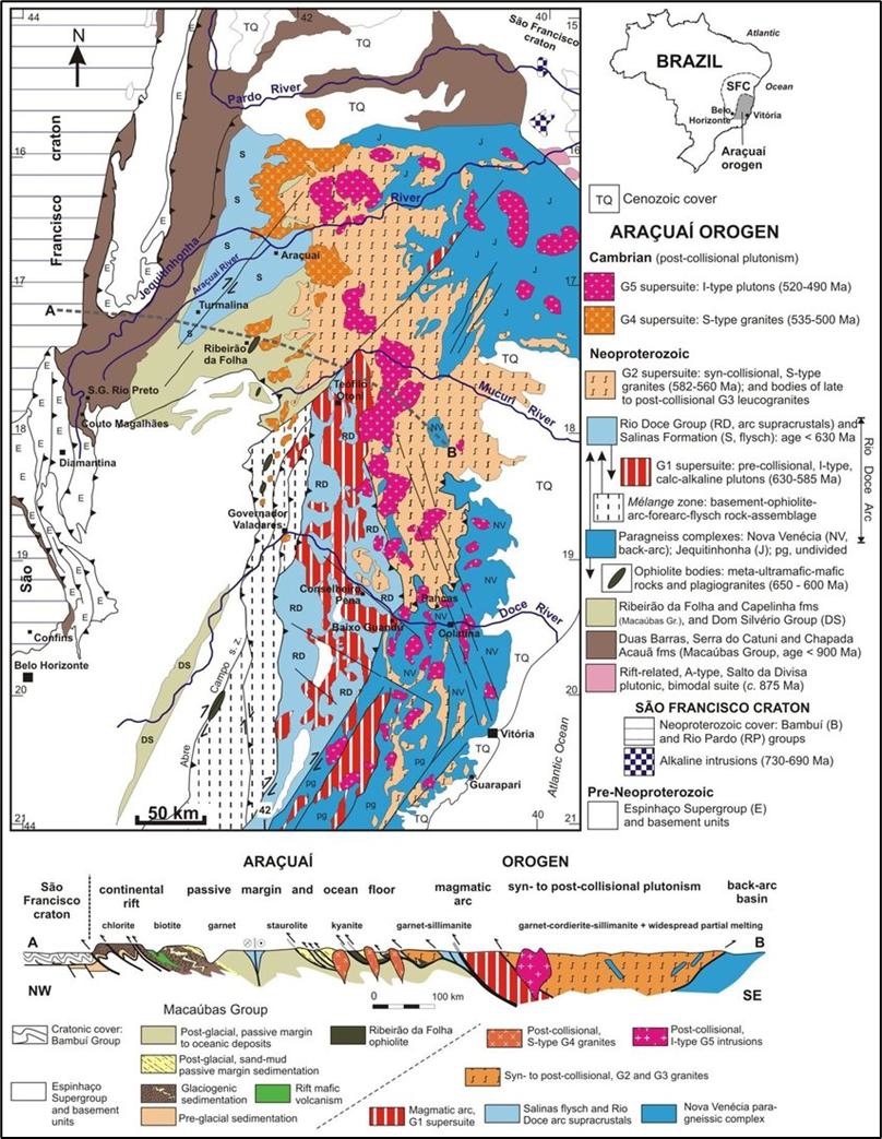
The South American Platform is composed of Archean and Proterozoic metamorphic and igneous complexes, forming the continental core of South America (Almeida, 1984). Its consolidation occurred between the late Proterozoic and early Paleozoic, during the Brasiliano/Pan-African Orogenic Cycle (Trompette, 1994). This platform comprises three main shield areas, represented by cratons and Neoproterozoic fold belts: the Guiana Shield, the Central Brazil Shield, and the Atlantic Shield. The latter includes the São Francisco Craton and its surrounding belts (Almeida, 1984). The Araçuaí Belt borders the São Francisco Craton to the east and is part of the system of mobile belts associated with the amalgamation of the Gondwana supercontinent (Pedrosa-Soares and Wiedmann, 2000) (Figure 6-1).
The evolution of the Araçuaí Orogen began with the opening of the Macaúbas Basin (~880 Ma) in an advanced continental rift setting, possibly forming a confined oceanic basin with limited development of oceanic crust. During this stage, the Capelinha and Chapada Acauã units were deposited. The closure of the basin led to the collision between the São Francisco and Congo cratons (~580 Ma), causing deformation and metamorphism of the entire Macaúbas Group sequence, including glacial units (Chapada Acauã) and volcano-sedimentary units (Ribeirão da Folha). Following the collision, orogenic collapse occurred, accompanied by the deposition of the Salinas Formation in post-collisional basins (Pedrosa-Soares et al., 2007).
The basement of the Araçuaí Orogen is composed of Archean and Paleoproterozoic complexes such as Guanhães, Gouveia, Porteirinha, Mantiqueira, Juiz de Fora, and Pocrane, all reworked during the Brasiliano orogeny. These complexes include TTG gneisses, migmatites, and granitoids, with isotopic signatures indicating ancient crustal sources. In the western portion of the orogen, the Espinhaço Supergroup crops out, comprising rift-related sequences that were deformed during the Brasiliano event (Noce et al., 2007; Degler et al., 2018).
The Macaúbas Group records the evolution of a Neoproterozoic basin that transitioned from a continental rift to a passive margin, with incipient oceanic crust formation, interpreted from tectonic ophiolites, plagiogranites, and records from the Ribeirão da Folha Formation. It is subdivided into pre-glacial, glacial, and post-glacial successions. The Capelinha Formation (pre-glacial) comprises graphitic metapelites associated with quartzites and amphibolites. The Ribeirão da Folha Formation (post-glacial) includes graphitic schists interlayered with turbidites and calcsilicate rocks in the western portion, and an ophiolitic sequence with graphite in metasedimentary rocks in the eastern portion (Pedrosa-Soares et al., 2007; Castro, 2014; Queiroga et al., 2007).
| S-K 1300 Technical Report – Malacacheta Graphite Project – Minas Gerais, Brazil | Page 16 |
Figure 6-1 Geological Map of the Araçuaí Orogen
| S-K 1300 Technical Report – Malacacheta Graphite Project – Minas Gerais, Brazil | Page 17 |
| 6.2 | Local and Property Geology |
The project area is located in the central-northern portion of the state of Minas Gerais, where units of the Macaúbas Group predominate—particularly the Capelinha and Ribeirão da Folha formations—which occur as narrow, strongly deformed bands. These units outcrop amidst the gneisses of the Guanhães Group, represented in the region mainly by the Serra Negra Formation, which shows no evidence of graphite mineralization.
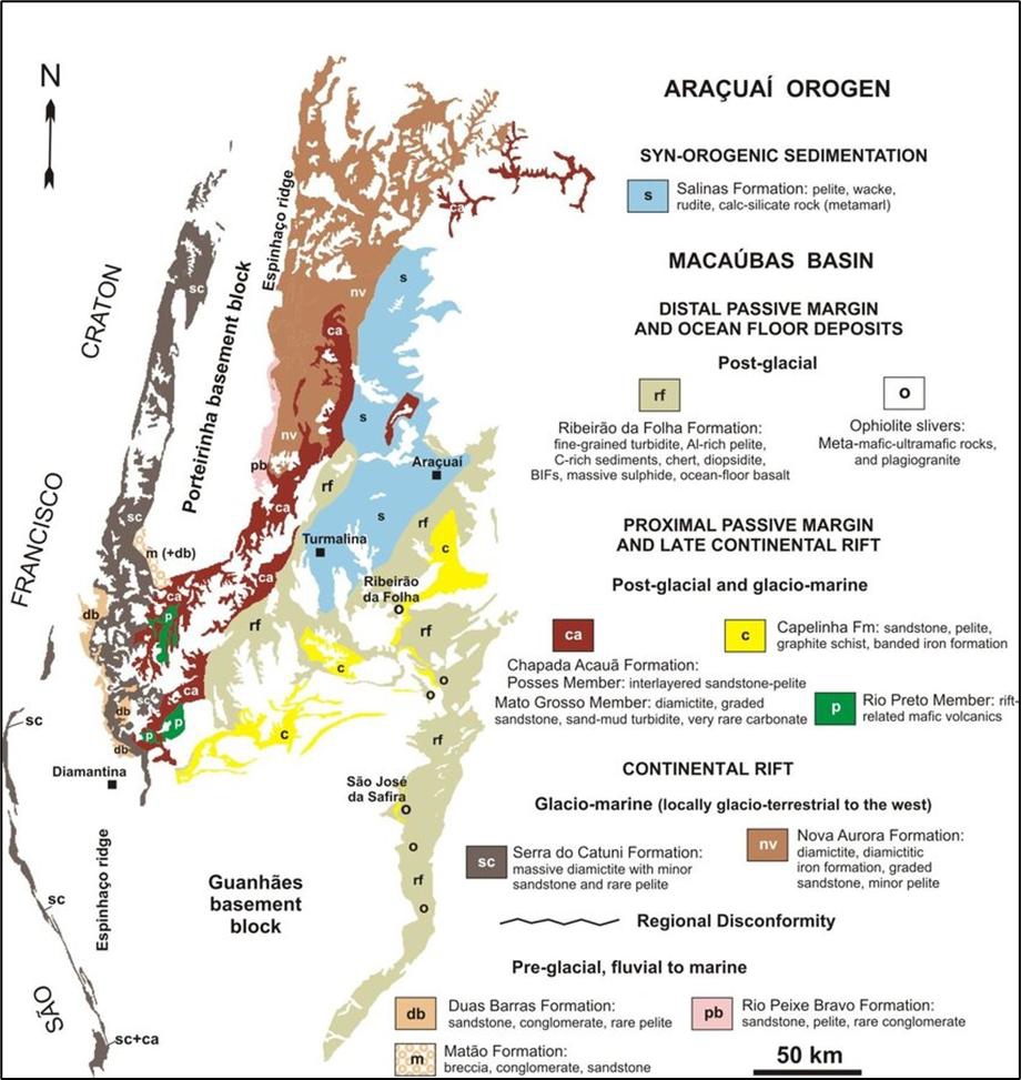
The Capelinha Formation, a pre-glacial unit, is composed of graphitic metapelites, quartzites, and amphibolites. The Ribeirão da Folha Formation, on the other hand, is post-glacial in nature and consists of graphitic schists interlayered with turbidites, calc-silicate rocks, and a well-developed ophiolitic sequence in the eastern portion of the basin (Pedrosa-Soares et al., 2007; Queiroga et al., 2007; Castro, 2014). Metamorphism and deformation resulting from the São Francisco–Congo collision (~580 Ma) facilitated the transformation of these carbon-rich sediments into graphite. Figure 6-2 shows the simplified geology of the Macaúbas Group.
The rocks of the Guanhães Group, consist of banded gneisses interlayered with quartzite and amphibolite. Based on geochronological data from Müller et al. (1986), an Archean age is inferred for the Guanhães rocks, which form the basement to the Neoproterozoic cover of the Macaúbas Group.
The contact between the Guanhães and Macaúbas Groups is strongly deformed, with the development of mylonitic zones indicating intense shearing. The regional structural framework is characterized by E-W-trending isoclinal folds, with shear zones and predominantly dextral movement oriented NW-SE (Pedrosa-Soares & Wiedemann, 2000).
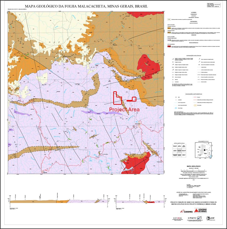
The rocks of the Macaúbas Group occur in the northern half of the project area, as well as in narrow bands in the southern portion, and are mainly represented in the area of interest by the Capelinha and Ribeirão da Folha formations, which host the most significant graphite mineralizations. Although other units are part of the Macaúbas Group, these two formations are the most relevant in terms of graphite mineralization (Castro, 2014). Figure 6-3 shows the local geology of the Malacachetas project area.
Regional metamorphism in the Araçuaí Belt—particularly affecting the Capelinha and Ribeirão da Folha units—ranges from greenschist to granulite facies, showing a progressive increase in metamorphic grade from NW to SE (Degler et al., 2018; Queiroga et al., 2007). The Capelinha Formation records typical amphibolite facies conditions, while the Ribeirão da Folha Formation presents evidence of medium- to high-grade metamorphism, including the presence of minerals such as sillimanite and garnet, indicating zones near the amphibolite–granulite transition (Castro, 2014).
This entire geological package was later affected by magmatic events associated with the late to post-tectonic granitogenesis of the Araçuaí Orogen, marked by the intrusion of granitoids dated between 560 and 500 Ma. These granites cut across both the basement and the metasedimentary units of the Macaúbas Group, including the Capelinha and Ribeirão da Folha formations, and are associated with the orogenic collapse phase and thermal reequilibration of the crust (Pedrosa-Soares et al., 2001; Silva et al., 2015).
Recent sedimentary covers of the colluvial-detrital type overlie parts of the Macaúbas Group units in the northern and northwestern portions of the project area. The Malacacheta region and its surroundings—particularly toward Teófilo Otoni—are known for a wide variety of mineral resources. In addition to graphite deposits, notable occurrences include gemstones such as alexandrite, citrine, aquamarine, beryl, tourmaline, quartz, and mica (CPRM, 2003; Ferreira et al., 2016).
| S-K 1300 Technical Report – Malacacheta Graphite Project – Minas Gerais, Brazil | Page 18 |
Figure 6-2 Simplified Geology of the Macaúbas Group (Pedrosa-Soares et al., 2007)
| S-K 1300 Technical Report – Malacacheta Graphite Project – Minas Gerais, Brazil | Page 19 |
Figure 6-3 Local Geology of the Malacacheta Project
| 6.3 | Deposit Type |
The mineralization at the Malacacheta project is classified as a flake graphite occurrence.
Flake graphite deposits are formed in regional metamorphic sequences ranging from upper amphibolite to granulite grade, coeval with peak metamorphism, and may also be found in the same districts as vein deposits. Texturally, flake graphite deposits vary from disseminations to high-grade (> 50 wt.%) concentrations in pods or lenses that are typically focused along lithologic contacts and within fold hinges (Case et al., 2023).
Crystalline flake graphite deposits are usually sedimentary in origin. They occur when carbon-rich organic content accumulated during sedimentation is transformed into graphitic carbon crystals, or flakes, during metamorphism. They are commonly stratabound and hosted by porphyroblastic and granoblastic paragneiss, marbles, and quartzites (Harben and Kuzvart, 1996). Alumina-rich paragneiss and marble units in upper amphibolite or granulite grade metamorphic terranes are the most favourable host rocks. When present, flake graphite usually occurs in thin, centimeter to metre wide bands. In favourable conditions, wider coalescing bands in fold crests can provide sufficient volume needed for an economic deposit.
Economically significant deposits are several metres to tens of metres thick and hundreds of metres in strike length. The economic quantifiers in flake graphite deposits are mostly graphite flake size, quantity and purity. According to Simandl, G.J. and Kenan, W.M. (1997), “Grade and tonnage of producing mines and developed prospects varies substantially. The median grade and size is 9.0 % C(g) and 2.4 M tonnes respectively (Bliss and Sutphin, 1992). Depending on market conditions, large deposits containing high proportions of coarse flakes, which can be easily liberated, may be economic with grades as low as 4 %”.
| S-K 1300 Technical Report – Malacacheta Graphite Project – Minas Gerais, Brazil | Page 20 |
| 7 | EXPLORATION |
Initial exploration started in 2023 and Atlas Critical Minerals identified surface outcrops with visible graphite, delineated mineralized bodies, and established a primary structural trend. Rock samples were collected (nine samples), and preliminary auger core drilling was conducted (21 drill holes), providing strong indications of the project’s potential.
Further exploration was undertaken in 2024, which expanded the understanding of the Malacacheta Project’s mineral potential. Atlas Critical Minerals systematically mapped and described 43 new points, paying close attention to surface exposures. A comprehensive sampling program was completed, with 17 samples of graphite schist and mica-schist with graphite collected from the two exploration permit areas.
Atlas Critical Minerals identified significant graphite schist bodies within both exploration areas, intercalated as lenses within mica schist. The tenement 830.954/2021 stands out as the most promising, with two highly significant occurrences observed, mapped and sampled.
The geology team carried out the following mineral exploration activities:
| ● | Compilation of public data: GIS database containing mainly lithologies, geophysics, public mapping data. | |
| ● | Geological reconnaissance: Two geological reconnaissance campaigns were carried out in the area, one in 2023 and the second in 2024, with the identification of graphitic outcrops, collection of samples and delimitation of bodies | |
| ● | Sampling: 9 samples were collected during the first geological reconnaissance field (2023) and 17 samples in the second campaign in 2024. | |
| ● | Auger drilling: A total of 21 auger holes were drilled on the property in 2023. |
| 7.1 | Surface Sampling |
In the 2023 exploration campaign, a total of nine surface samples were collected across the two tenements. Figure 7-1 shows the location of the samples.
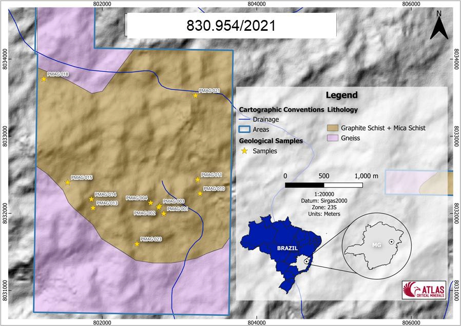
The 2024 exploration campaign saw a total of 12 samples collected from tenement 830.954/2021. Figure 7-2 shows the location of the samples.
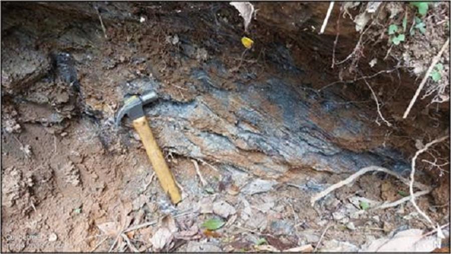
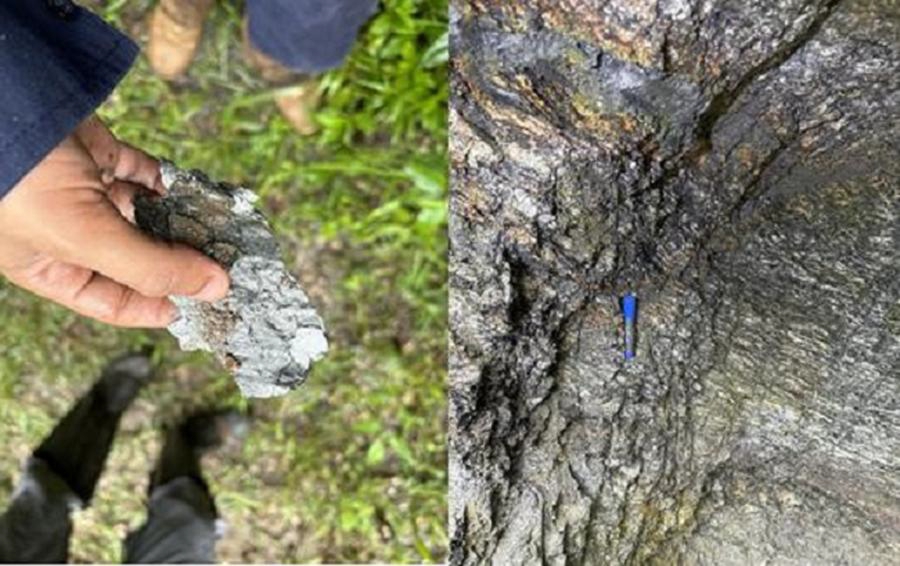
Figure 7-3 to Figure 7-5 show some of the outcrops mapped and sampled.
| S-K 1300 Technical Report – Malacacheta Graphite Project – Minas Gerais, Brazil | Page 21 |
Figure 7-1 Surface Samples from 2023 Exploration Campaign
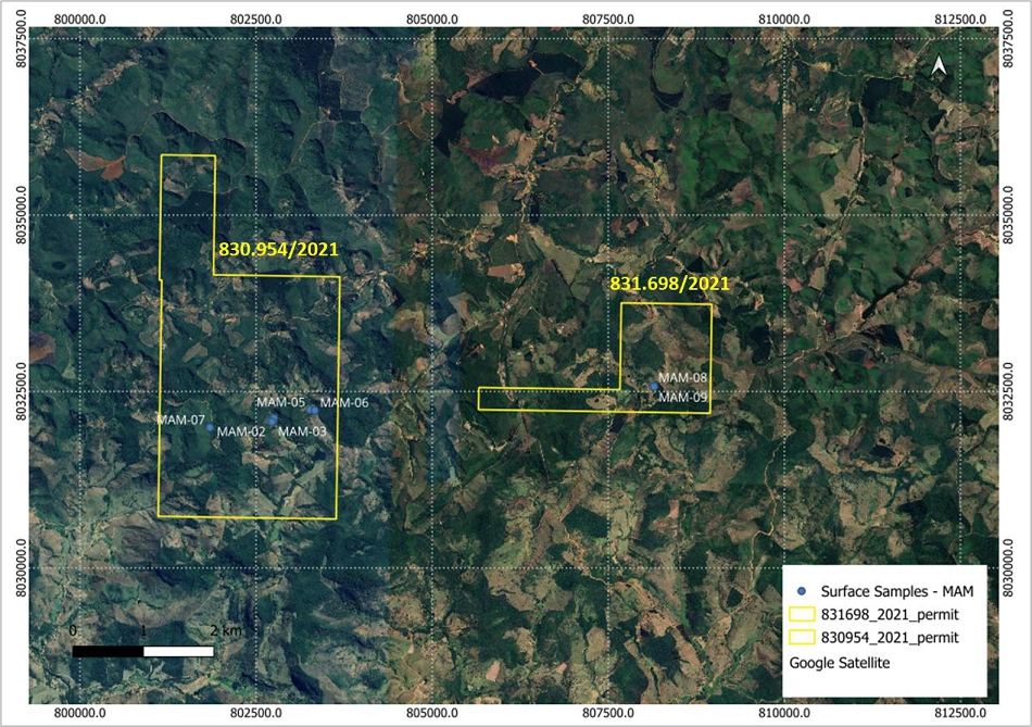
Figure 7-2 Surface Samples from 2024 Exploration Campaign
| S-K 1300 Technical Report – Malacacheta Graphite Project – Minas Gerais, Brazil | Page 22 |
Figure 7-3 Outcrop of Graphitic Mica Schist with Intercalated Gneiss Layers
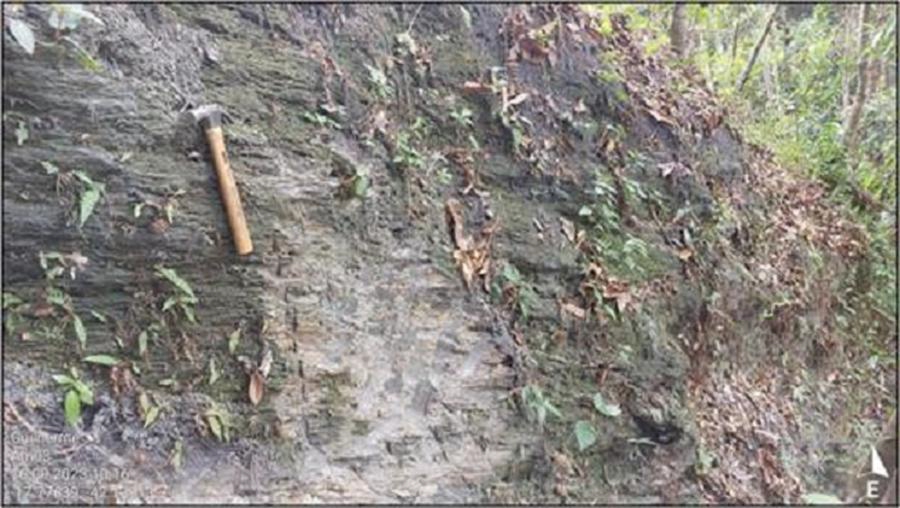
Figure 7-4 Outcrop of Graphitic Mica Schist with Flake Graphite
| S-K 1300 Technical Report – Malacacheta Graphite Project – Minas Gerais, Brazil | Page 23 |
Figure 7-5 Flake Graphite and Graphitic Schist Outcrop
| 7.2 | Auger Drilling |
A campaign of auger drilling was undertaken during the 2023 exploration program. A total of 21 auger holes were drilled around a prospective area in tenement 831.698/2021.
Seven holes intercepted graphite in a roughly north-south trending corridor. Figure 7-6 shows the location of the auger holes and Table 7-1 shows the significant assays.
It should be noted that three of the holes finished in graphitic schist, as the auger was at refusal.
| S-K 1300 Technical Report – Malacacheta Graphite Project – Minas Gerais, Brazil | Page 24 |
Figure 7-6 Location of Auger Holes in Tenement 831.698/2021
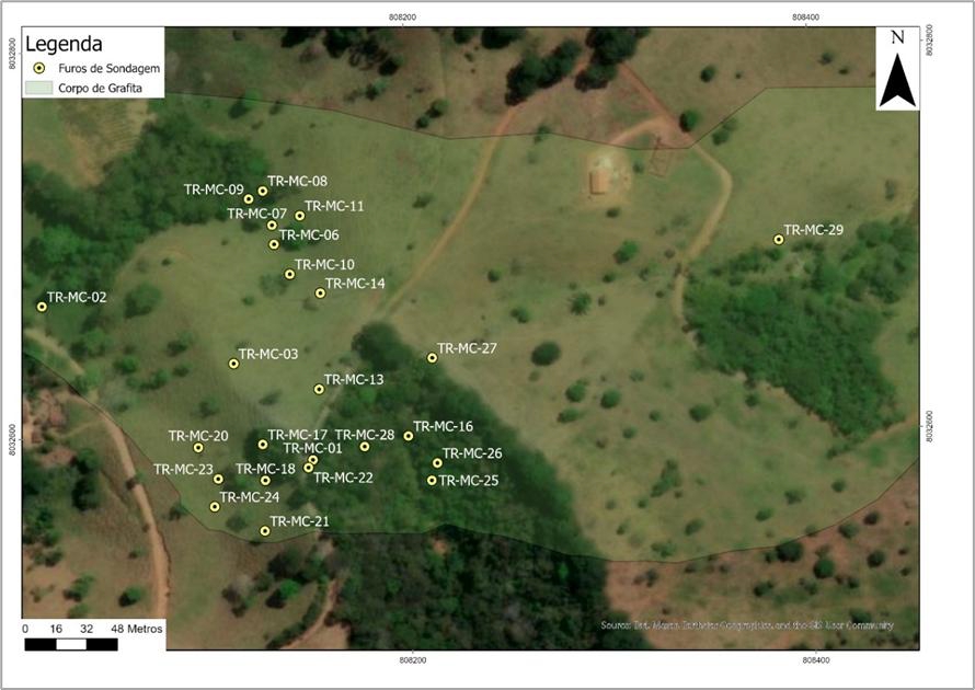
Table 7-1 Assay Results from 2023 Auger Drilling Campaign
| Auger Hole | From (m) | To (m) | Intercept (m) |
Graphite (%) | ||||
| TR-MC-01 | 0 | 3 | 3 | 7.74 | ||||
| 7 | 10 | 3 | 5.68 | |||||
| TR-MC-04 | 10 | 13 | 3 | 5.20 | ||||
| 21 | 23* | 2 | 4.84 | |||||
| TR-MC-06 | 1 | 3 | 2 | 3.78 | ||||
| TR-MC-07 | 3 | 5 | 2 | 5.12 | ||||
| TR-MC-08 | 2 | 4 | 2 | 4.63 | ||||
| TR-MC-10 | 10 | 12* | 2 | 4.02 | ||||
| TR-MC-25 | 2 | 8* | 6 | 6.30 |
Note: * denotes hole that finished in graphitic schist.
| S-K 1300 Technical Report – Malacacheta Graphite Project – Minas Gerais, Brazil | Page 25 |
| 8 | SAMPLE PREPARATION, ANALYSES, AND SECURITY |
This section is not relevant to this Report.
| S-K 1300 Technical Report – Malacacheta Graphite Project – Minas Gerais, Brazil | Page 26 |
| 9 | DATA VERIFICATION |
No property inspection has been completed at this time.
| S-K 1300 Technical Report – Malacacheta Graphite Project – Minas Gerais, Brazil | Page 27 |
| 10 | MINERAL PROCESSING AND METALLURGICAL TESTING |
| 10.1 | Scope |
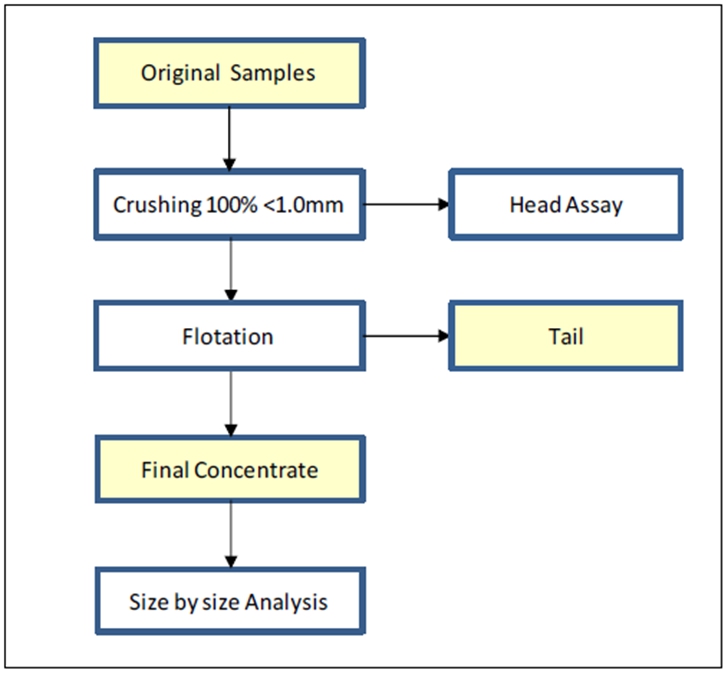
Atlas submitted nine samples collected at the property to SGS Geosol in Belo Horizonte, Brazil. The test work comprised:
| ● | crushing samples to top size of 1.0 mm | |
| ● | determining the head assay of the samples | |
| ● | flotation after regrinding and attrition for two of the samples | |
| ● | size-by-size analysis of the final flotation concentrates |
Figure 10-1 shows the test work flowsheet.
Figure 10-1 Test Work Flowsheet for Graphite Samples
| 10.2 | Methods of Chemical Analysis |
Chemical analysis of the original samples and their products was conducted by the following methods:
| ● | GC_CSA05V: determination of graphitic carbon via LECO | |
| ● | XRF82GR: x-ray fluorescence to determine the contaminants | |
| ● | PHY01E: lost on ignition | |
| ● | PHY00D: ashes determination by gravimetry. | |
| ● | GC_ICP40BGR: ICP scan of the ashes |
| S-K 1300 Technical Report – Malacacheta Graphite Project – Minas Gerais, Brazil | Page 28 |
| 10.3 | Flotation |
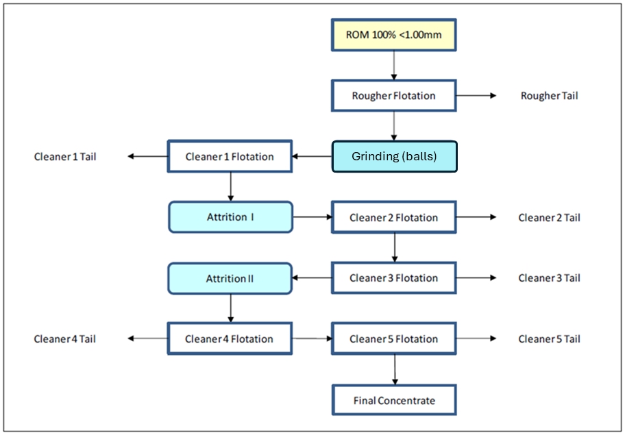
The flotation test work included rougher flotation, grinding and five stages of cleaning with two attrition stages in between. It is important to note there are no circulating loads in the flowsheet, so that all flotation tailings are final. The flotation test work was performed in an open circuit.
All flotation tests were conducted by means of the Denver D12 mechanism equipped with air filters, air flowmeter and tachometer. Cell volume was 13 litres, impeller speed was 1600 rpm, air flowrate was 4.0 litres per minute were the same for both rougher and cleaner. The reagent scheme, however, was different for each stage:
| ● | rougher: 1000 g/t of dispersant (Sodium silicate), 375 g/t of collector (Kerosene) and 200 g/t of frother (Flotanol D-25); | |
| ● | cleaner 1, 2 and 4: 50 g/t of collector (Kerosene) and 25 g/t of frother (Flotanol D-25); | |
| ● | no reagents were added to cleaner 3 and 5. |
Grinding of the rougher concentrate was conducted by means of a 12 cm x 20 cm mill, charged with a load of 2.25 kg of 12.5 mm ball load for 10 minutes. The concentrates from cleaner 1 and 3 were submitted to attrition for 10 minutes at 1400 rpm by means of a scrubber which was immersed in zirconia beads of 2.4 mm diameter to form the grinding media. Due to the design of the scrubber, the pulp was forced to flow in opposite directions between the blades, effectively scouring the particle surfaces and removing debris and contaminants.
Figure 10-2 Flotation Test Work Flowsheet
| S-K 1300 Technical Report – Malacacheta Graphite Project – Minas Gerais, Brazil | Page 29 |
| 10.4 | Sample Receiving |
In May 2025, Atlas sent surface outcrop samples to SGS Geosol. The samples were packed in individual plastic sample bags, with the sample ID clearly indicated on the outside of each bag.
Atlas submitted a total of 12 samples for test work, each weighing approximately 25 kg. Some samples were combined to form the final nine samples tested. Table 10-1 shows the final sample designations for test work.
Table 10-1 Sample Identification and Weight
| Sample ID | Number of Units | Total Mass (kg) | ||
| SMAL - 00001 | 1 | 21.5 | ||
| SMAL – 00002 | 1 | 24.2 | ||
| SMAL – 00003 | 1 | 23.1 | ||
| SMAL – 00004 | 3 | 71.0 | ||
| SMAL – 00005 | 2 | 49.2 | ||
| SMAL – 00006 | 1 | 24.3 | ||
| SMAL – 00007 | 1 | 24.3 | ||
| SMAL – 00008 | 1 | 23.6 | ||
| SMAL - 00009 | 1 | 25.0 |
| 10.5 | Chemical Analysis of The Original Samples |
Results of the chemical analysis of the original samples via LECO, XRF and LOI are summarized in Table 10-2. These results indicate a range of 1.71% to 15.4% for graphitic carbon, with an average of 9.07%. The main contaminants were identified as silicates, ranging from 50% to 69% in terms of SiO2, as well as aluminum, from 12.7% to 21.3% Al2O3 and iron, from 1.53% to 18.1% Fe2O3.
The loss on ignition value (LOI) represents the weight percentage of all volatile substances released at a calcination temperature of 1100 °C, including graphitic carbon, as well as moisture, sulfur, organic matter and hydroxides. In this context, the sum of the content of graphitic carbon and other volatile substances in the ore is equivalent to the LOI, while the sum of the LOI and the oxides shown in Table 10-2 approaches 100 %.
| S-K 1300 Technical Report – Malacacheta Graphite Project – Minas Gerais, Brazil | Page 30 |
Table 10-2 Analysis Results for LECO, XRF and LOI
| Chemical Composition of the Original Samples | ||||||||||||||||||||||||||||
| Sample | C-Graph (%) |
LOI (%) |
Al2O3 (%) |
BaO (%) |
Cr2O3 (%) |
Fe2O3 (%) |
K2O (%) |
MgO (%) |
MnO (%) |
P2O5 (%) |
SiO2 (%) |
SrO (%) |
TiO2 (%) |
V2O5 (%) | ||||||||||||||
| SMAL-00001 | 15.4 | 19.4 | 13.1 | 0.04 | 0.03 | 3.24 | 1.31 | 0.35 | 0.01 | 0.05 | 62.3 | 0.02 | 0.72 | 0.09 | ||||||||||||||
| SMAL-00002 | 3.24 | 13.5 | 21.3 | 0.07 | 0.02 | 6.65 | 0.64 | <0.1 | 0.02 | 0.14 | 56.9 | 0.02 | 1.32 | 0.06 | ||||||||||||||
| SMAL-00003 | 1.71 | 10.3 | 13.6 | 0.04 | <0.01 | 5.43 | 0.34 | <0.1 | 0.05 | 0.12 | 69.3 | 0.02 | 1.22 | 0.04 | ||||||||||||||
| SMAL-00004 | 11.1 | 15.2 | 16.1 | 0.11 | 0.05 | 3.56 | 2.12 | 0.28 | <0.01 | 0.06 | 26.4 | 0.02 | 0.85 | 0.09 | ||||||||||||||
| SMAL-00005 | 11.5 | 14.2 | 13.7 | 0.11 | 0.03 | 1.78 | 2.26 | 0.31 | <0.01 | 0.09 | 68.1 | 0.02 | 0.67 | 0.11 | ||||||||||||||
| SMAL-00006 | 12.2 | 15.1 | 12.7 | 0.13 | 0.02 | 1.53 | 2.09 | 0.24 | 0.01 | 0.08 | 68.5 | 0.04 | 0.70 | 0.09 | ||||||||||||||
| SMAL-00007 | 13.4 | 17.4 | 14.5 | 0.15 | 0.02 | 4.76 | 2.01 | 0.28 | 0.02 | 0.11 | 61.1 | 0.02 | 0.93 | 0.06 | ||||||||||||||
| SMAL-00008 | 11.3 | 14.8 | 15.4 | 0.09 | 0.02 | 1.93 | 2.30 | 0.32 | 0.01 | 0.07 | 65.1 | 0.02 | 0.72 | 0.09 | ||||||||||||||
| SMAL-00009 | 1.89 | 10.7 | 19.9 | 0.04 | 0.03 | 18.1 | 0.48 | 0.28 | 0.04 | 0.26 | 50.1 | 0.02 | 1.20 | 0.05 | ||||||||||||||
Results of PHY00D are summarized in Table 10-3, representing the weight percent of the remnants from calcination, that is, 100 – LOI.
Table 10-3 Analysis Results for PHY00D on Ashes
| Chemical Composition of the Original Samples | ||||||||||||||||||||||||||||
| Sample | Ashes (%) |
Al_C (%) |
Ca_C (%) |
Fe_C (%) |
K_C (%) |
Mg_C (%) |
Na_C (%) |
P_C (%) |
Ti_C (%) |
Ba_C (%) |
Cu_C (%) |
La_C (%) |
Sr_C (%) |
V_C (%) | ||||||||||||||
| SMAL-00001 | 80.6 | 3.11 | 0.02 | 1.82 | 0.98 | 0.17 | 0.05 | 0.02 | 0.17 | 392 | 26.0 | 61.0 | 30.0 | 462 | ||||||||||||||
| SMAL-00002 | 86.5 | 6.61 | 0.02 | 3.71 | 0.45 | 0.04 | 0.09 | 0.05 | 0.50 | 503 | 54.0 | 52.0 | 62.0 | 290 | ||||||||||||||
| SMAL-00003 | 89.5 | 5.17 | 0.03 | 3.39 | 0.27 | 0.04 | 0.02 | 0.05 | 0.44 | 341 | 44.0 | 63.0 | 58.0 | 174 | ||||||||||||||
| SMAL-00004 | 84.5 | 5.36 | 0.01 | 2.14 | 1.61 | 0.14 | 0.09 | 0.03 | 0.29 | 948 | 21.0 | 49.0 | 41.0 | 436 | ||||||||||||||
| SMAL-00005 | 85.6 | 4.94 | 0.02 | 1.09 | 1.79 | 0.15 | 0.11 | 0.03 | 0.25 | 959 | 13.0 | 53.0 | 130 | 490 | ||||||||||||||
| SMAL-00006 | 84.6 | 4.63 | 0.02 | 0.94 | 1.64 | 0.15 | 0.09 | 0.03 | 0.25 | 890 | 18.0 | 56.0 | 117 | 487 | ||||||||||||||
| SMAL-00007 | 82.9 | 4.88 | 0.01 | 2.84 | 1.57 | 0.15 | 0.09 | 0.04 | 0.32 | 1155 | 30.0 | 57.0 | 122 | 273 | ||||||||||||||
| SMAL-00008 | 83.8 | 4.63 | 0.01 | 1.11 | 1.80 | 0.15 | 0.11 | 0.03 | 0.26 | 867 | 35.0 | 46.0 | 84.0 | 456 | ||||||||||||||
| SMAL-00009 | 89.1 | 6.52 | 0.02 | 11.4 | 0.35 | 0.14 | 0.02 | 0.10 | 0.53 | 345 | 71.0 | 52.0 | 23.0 | 258 | ||||||||||||||
| S-K 1300 Technical Report – Malacacheta Graphite Project – Minas Gerais, Brazil | Page 31 |
| 10.6 | Flotation Results |
The samples with the highest and second lowest head grade respectively, SMAL - 00001 and SMAL - 00009 of 15.4% and 1.89% graphitic carbon, were submitted to flotation as per the flowsheet in Figure 10-2. The main objective of testing these two samples was to ensure the experimental conditions were suitable for the Malacacheta mineralization, in order to produce a final concentrate of high grade. The flotation results summarized in Table 10-4 and Table 10-5 indicated that:
| ● | sample SMAL - 00001 generated a final concentrate of high grade and recovery, namely, 91.9% graphitic carbon and 95.1% metallurgical recovery | |
| ● | the final concentrate generated by sample SMAL - 00009 was also high in grade, at 96.5% graphitic carbon, but the metallurgical recovery dropped to 73.6%. |
Table 10-4 Flotation Results for SMAL-00001
| Flotation: SMAL-00001 | ||||||||
| Mass | Graphitic Carbon (%) | |||||||
| Stage | (g) | (%) | Assay | Distribution | ||||
| ROM EXPERIMENTAL | 2000 | - | 15.4 | - | ||||
| ROM CALCULATED | 1966 | 100 | 15.4 | 100 | ||||
| ROUGHER TAIL | 1112 | 56.6 | 0.48 | 1.76 | ||||
| ROUGHER CONC | 854 | 43.4 | 34.9 | 98.2 | ||||
| CLEANER 1 TAIL | 324 | 16.5 | 0.47 | 0.50 | ||||
| CLEANER I CONC | 530 | 27.0 | 56.0 | 97.7 | ||||
| CLEANER II TAIL | 158 | 8.04 | 0.50 | 0.26 | ||||
| CLEANER II CONC | 372 | 18.9 | 79.5 | 97.5 | ||||
| CLEANER III TAIL | 25.0 | 1.27 | 4.87 | 0.40 | ||||
| CLEANER III CONC | 347 | 17.7 | 84.9 | 97.1 | ||||
| CLEANER IV TAIL | 25.0 | 1.27 | 9.28 | 0.76 | ||||
| CLEANER IV CONC | 322 | 16.4 | 90.8 | 96.3 | ||||
| CLEANER V TAIL | 8.00 | 0.41 | 44.7 | 1.18 | ||||
| CLEANER V CONC | 314 | 16.0 | 91.9 | 95.1 | ||||
| S-K 1300 Technical Report – Malacacheta Graphite Project – Minas Gerais, Brazil | Page 32 |
Table 10-5 Flotation Results for SMAL-00009
| Flotation: SMAL-00009 | ||||||||
| Mass | Graphitic Carbon (%) | |||||||
| Stage | (g) | (%) | Assay | Distribution | ||||
| ROM EXPERIMENTAL | 2000 | - | 1.89 | - | ||||
| ROM CALCULATED | 1909 | 100 | 2.09 | 100 | ||||
| ROUGHER TAIL | 1603 | 84.0 | 0.40 | 16.0 | ||||
| ROUGHER CONC | 306 | 16.0 | 11.0 | 84.0 | ||||
| CLEANER 1 TAIL | 202 | 10.6 | 1.22 | 6.15 | ||||
| CLEANER I CONC | 105 | 5.47 | 29.8 | 77.8 | ||||
| CLEANER II TAIL | 64.5 | 3.38 | 1.07 | 1.73 | ||||
| CLEANER II CONC | 40.0 | 2.10 | 76.0 | 76.1 | ||||
| CLEANER III TAIL | 5.50 | 0.29 | 10.5 | 1.45 | ||||
| CLEANER III CONC | 34.5 | 1.81 | 86.4 | 74.6 | ||||
| CLEANER IV TAIL | 3.50 | 0.18 | 6.09 | 0.53 | ||||
| CLEANER IV CONC | 31.0 | 1.62 | 95.5 | 74.1 | ||||
| CLEANER V TAIL | 0.50 | 0.03 | 37.0 | 0.46 | ||||
| CLEANER V CONC | 30.5 | 1.60 | 96.5 | 73.6 | ||||
| 10.7 | Size by Size Analysis |
The main objective of the tests was to evaluate whether the samples can be concentrated. It should be noted that in all particle size ranges, grades higher than 91% were obtained for sample SMAL-00001, and grades higher than 93% for sample SMAL-00009. The flotation concentrates generated by samples SMAL - 00001 and SMAL - 00009 were analyzed on a size-size basis. The results summarized in Table 10-6 and Table 10-7 indicate that:
| ● | for sample SMAL - 00001, the flakes in the -300 to +180 microns interval represent 9.23% of the sample mass, with the assay of graphitic carbon at 96.6%. The material in the minus 75-micron range accounted for 36.4% of total mass. | |
| ● | for sample SMAL - 00009, the flakes in the -300 to +180 microns interval represent 2.56% of the sample mass, with an assay value of 93.8% graphitic carbon, however, the material in the minus 75-micron range accounted for 69.2% of total mass. |
Table 10-6 Flotation Concentrate for SMAL-00001
| SMAL-00001 – Final Concentrate | ||||
Size Interval (µm) |
weight (%) |
C-Graph (%) | ||
| +300 | 1.03 | 93,0 | ||
| -300+180 | 9.23 | 96.6 | ||
| -180+150 | 9.74 | 94.5 | ||
| -150+75 | 43.6 | 93.1 | ||
| -75 | 36.4 | 91.3 | ||
| CONC CLN V CALC | 100 | 92.9 | ||
| CONC CLN V EXP | 100 | 91.9 | ||
| S-K 1300 Technical Report – Malacacheta Graphite Project – Minas Gerais, Brazil | Page 33 |
Table 10-7 Flotation Concentrate for SMAL-00009
| SMAL-00009 – Final Concentrate | ||||
Size Interval (µm) |
weight (%) |
C-Graph (%) | ||
| +300 | 0.00 | - | ||
| -300+180 | 2.56 | 93.8 | ||
| -180+150 | 5.13 | 95.3 | ||
| -150+75 | 23.1 | 97.7 | ||
| -75 | 69.2 | 93.0 | ||
| CONC CLN V CALC | 100 | 94.2 | ||
| CONC CLN V EXP | 100 | 96.5 | ||
| 10.8 | Results and Conclusion |
The results summarized in Table 10-8 indicate that the two samples used for flotation test work achieved grades between 91.3% and 97.7% graphitic carbon.
Using conventional flotation, regrinding and attrition techniques, the final graphite concentrates achieved grades of 91.9% and 96.5% total graphite carbon, demonstrating the amenability of the Malacacheta Project to flotation.
Table 10-8 Final Size Intervals and Grades for Flotation Test Work
Size Interval (µm) |
C-Graph (%) SMAL-00001 |
C-Graph (%) SMAL-00009 | ||
| +300 | 93.0 | - | ||
| -300+180 | 96.6 | 93.8 | ||
| -180+150 | 94.5 | 95.3 | ||
| -150+75 | 93.1 | 97.7 | ||
| -75 | 91.3 | 93.0 | ||
| CONC CLN V EXP | 91.9 | 96.5 |
Note: All carbon analyses are reported as graphite carbon (“C-graph”). The analytical methods that were used to determine the metallurgical results included total carbon analysis by Leco on the final concentrates.
Main conclusions arising from the test work are:
| ● | The content of graphitic carbon averaged 9.07% among the original samples, ranging from 1.71% for SMAL - 00003 to 15.4% for SMAL - 00001 | |
| ● | Flotation of both the highest and second lowest grade samples generated final concentrates of 96.5% graphitic carbon for SMAL - 00009 and 91.9% for SMAL - 00001 | |
| ● | Metallurgical recovery was 96.5% for SMAL - 00001 and 73.6% for SMAL - 00009 | |
| ● | The flakes in the -300+180 microns interval of the flotation concentrate generated by sample SMAL - 00001 represented 9.23% of the sample, with 96.6% graphitic carbon assay. For sample SMAL - 00009, the flakes represent only 2.56% of the sample mass and the material below 75 microns was up to 69.2%. |
| S-K 1300 Technical Report – Malacacheta Graphite Project – Minas Gerais, Brazil | Page 34 |
| 10.9 | Suggestion For Further Work |
In view of the results to date, it is strongly recommended that the work with the Atlas graphite mineralization be extended as follows:
| ● | Technological characterization tests | |
| ● | Tests with variations in process routes | |
| ● | Tests for grinding and flotation optimization, including LCT | |
| ● | Tests considering desliming | |
| ● | Tests to determine the optimal dosage and types of reagents | |
| ● | Conduct further flotation work using samples SMAL - 00009 and SMAL - 00001 to optimize the flotation conditions and apply those conditions to the other samples | |
| ● | Include total sulfur by LECO and exclude ICP in the chemical analysis of the original samples and flotation products | |
| ● | Test a larger number of samples to determine the variability of the deposit with geometallurgy studies |
| S-K 1300 Technical Report – Malacacheta Graphite Project – Minas Gerais, Brazil | Page 35 |
| 11 | MINERAL RESOURCE ESTIMATES |
There are no Mineral Resource Estimates on this Project.
| S-K 1300 Technical Report – Malacacheta Graphite Project – Minas Gerais, Brazil | Page 36 |
| 12 | MINERAL RESERVE ESTIMATES |
There are no Mineral Reserve Estimates on this Project.
| S-K 1300 Technical Report – Malacacheta Graphite Project – Minas Gerais, Brazil | Page 37 |
| 13 | MINING METHODS |
This section is not relevant to this Report.
| S-K 1300 Technical Report – Malacacheta Graphite Project – Minas Gerais, Brazil | Page 38 |
| 14 | PROCESSING AND RECOVERY METHODS |
This section is not relevant to this Report.
| S-K 1300 Technical Report – Malacacheta Graphite Project – Minas Gerais, Brazil | Page 39 |
| 15 | INFRASTRUCTURE |
This section is not relevant to this Report.
| S-K 1300 Technical Report – Malacacheta Graphite Project – Minas Gerais, Brazil | Page 40 |
| 16 | MARKET STUDIES |
This section is not relevant to this Report.
| S-K 1300 Technical Report – Malacacheta Graphite Project – Minas Gerais, Brazil | Page 41 |
| 17 | ENVIRONMENTAL STUDIES, PERMITTING, AND PLANS, NEGOTIATIONS, OR AGREEMENTS WITH LOCAL INDIVIDUALS OR GROUPS |
This section is not relevant to this Report.
| S-K 1300 Technical Report – Malacacheta Graphite Project – Minas Gerais, Brazil | Page 42 |
| 18 | CAPITAL AND OPERATING COSTS |
This section is not relevant to this Report.
| S-K 1300 Technical Report – Malacacheta Graphite Project – Minas Gerais, Brazil | Page 43 |
| 19 | ECONOMIC ANALYSIS |
This section is not relevant to this Report.
| S-K 1300 Technical Report – Malacacheta Graphite Project – Minas Gerais, Brazil | Page 44 |
| 20 | ADJACENT PROPERTIES |
There is no information on properties adjacent to the Project necessary to make the TRS understandable and not misleading.
| S-K 1300 Technical Report – Malacacheta Graphite Project – Minas Gerais, Brazil | Page 45 |
| 21 | OTHER RELEVANT DATA AND INFORMATION |
No other information or explanation is necessary to take this TRS understandable and not misleading.
| S-K 1300 Technical Report – Malacacheta Graphite Project – Minas Gerais, Brazil | Page 46 |
| 22 | INTERPRETATION AND CONCLUSIONS |
SGS Geological Services Inc. (“SGS”) was contracted by Atlas Critical Minerals Corporation (“Atlas Critical Minerals” or the “Company”) to complete a Property of Merit for the Malacacheta Graphite Project near the city of Teófilo Otoni, Brazil, and to prepare a Public Report in accordance with the §§ 229.601(b)(96) Technical report (subpart 229.1300 of Regulation S-K) written in support of a Property of Merit on the Malacacheta Project.
This TRS conforms to the United States Securities and Exchange Commission’s (SEC) Modernized Property Disclosure Requirements for Mining Registrants as described in Subpart 229.1300 of Regulation S-K, Disclosure by Registrants Engaged in Mining Operations (S-K 1300) and Item 601 (b)(96) Technical Report Summary.
Initial exploration started in 2023, and Atlas Critical Minerals identified surface outcrops with visible graphite, delineated mineralized bodies, and established a primary structural trend. Rock samples were collected (nine samples), and preliminary auger core drilling was conducted (21 drill holes), providing strong indications of the project’s potential.
Further exploration was undertaken in 2024, which expanded the understanding of the Malacacheta Project’s mineral potential. Atlas Critical Minerals systematically mapped and described 43 new points, paying close attention to surface exposures and sub-surface features. A comprehensive sampling program was completed, with 17 samples of graphite schist and mica-schist with graphite collected from the two exploration permit areas.
| S-K 1300 Technical Report – Malacacheta Graphite Project – Minas Gerais, Brazil | Page 47 |
| 23 | RECOMMENDATIONS |
Atlas have defined further exploration work across the property, as detailed below. The QP recommends that Atlas proceed with these exploration programs.
| ● | A Geophysical Magnetometric Survey (Drone MAG) including electromagnetic (EM), Aerophotogrammetry, and detailed topographic surveying using Lidar, with a budget of US$ 75,000.00. | |
| ● | Detailed fieldwork, including the collection of samples for chemical analysis to support high-resolution geological mapping, to be carried out by Atlas Critical Minerals’s team of geologists, with a budget of US$ 85,000.00. | |
| ● | In addition, the program will include a 5,000-meter drilling campaign, supported by the implementation of all necessary infrastructure for a complete sample management and quality control chain. This will encompass chemical analyses, proper sample storage in a dedicated facility, and the application of rigorous QA/QC protocols. The estimated budget for this phase is US$1,550,000.00 | |
| ● | The Atlas team will be responsible for managing and supervising field activities, with a budget of US$ 160,000.00. | |
| ● | Metallurgical Testing and SK-1,300 resource report with US$ 170,000.00. | |
| ● | Contingency US$ 105,000.00. | |
| ● | Totaling a value of US$ 2,145,000.00 for the resource report definition of both areas. |
| S-K 1300 Technical Report – Malacacheta Graphite Project – Minas Gerais, Brazil | Page 48 |
| 24 | REFERENCES |
Alkmim, F., Marshak, S., Pedrosa-Soares, A.C., Peres, G., Cruz, S., and Whittington, A., 2007. Kinematic evolution of the Araçuaí-West Congo orogen in Brazil and Africa: Nutcracker tectonics during the Neoproterozoic assembly of Gondwana. Precambrian Research - PRECAMBRIAN RES. 149. 43-64. 10.1016/j.precamres.2006.06.007.
Almeida, F.F.M., 1977. O Cráton do São Francisco. Rev Bras Geocięnc 7: 349-364
Almeida, F. F. M. Fundamentos geológicos do Brasil. São Paulo: Instituto de Geociências da USP, 1984. 422 p.
Amaral, R., Ferreire, R., and Savassi, O., 2025. Final Report Technological Characterization or Graphite Ore, 4181-2503, June 3, 2025, prepared for Atlas Lithium, SGS Geosol.
Babinski, M.; et al. U-Pb geochronology on detrital zircon from the Espinhaço and Macaúbas groups: implications for the São Francisco paleocontinent. Precambrian Research, v. 159, n. 1-2, p. 1–17, 2007.
Barrote, V.R., Rosiere, C.A., Rolim, V.K., Santos, J.O.S. and McNaughton, N.J., 2017. The Proterozoic Guanhães banded iron formations, Southeastern border of the São Francisco Craton, Brazil: evidence of detrital contamination. Geol. USP, Sér. cient., São Paulo, v. 17, n. 2, p. 30-324
Bliss, J.D. and Sutphin, D.M. 1992. Grade and Tonnage Model of Disseminated Flake Graphite: Model 371; in G.J. Orris and J.D. Bliss, Editors; US, Geological Survey, Open File Report 92-437, pages 67. 70.
Case, G.N.D., Karl, S.M., Regan, S.P., Johnson, C.A., Ellison, E.T., Caine, J.S., Holm-Denoma, C.S., Pianowski, L.S. and Marsh, J.H., 2023. Insights into the metamorphic history and origin of flake graphite mineralization at the Graphite Creek graphite deposit, Seward Peninsula, Alaska, USA. Mineralium Deposita, Volume 58, pages 939–962.
Castro, N. A. Evolução geotectônica da Formação Capelinha, Grupo Macaúbas, na região de Capelinha-MG: implicações para a margem leste do Orógeno Araçuaí. 2014. Tese (Doutorado) – Universidade Federal de Minas Gerais, Belo Horizonte, 2014.
Degler, S. A.; et al. The São Francisco Craton and its margins: an overview. Journal of South American Earth Sciences, v. 86, p. 117–138, 2018.
Grossi-Sad, J. H. G. (1997). Geologia da Folha Guanhães. In: J. H. G. Grossi-Sad, L. M. Lobato, A. C. P. Soares, B. S. Soares-Filho (Eds.), Projeto Espinhaço em CD-ROM (textos, mapas e anexos) (2317-2435). Belo Horizonte: COMIG.
Grossi-Sad, J. H. G., Chiodi Filho, C., Santos, J. F., Magalhães, J. M. M., Carelos, P. M. (1990a). Duas Suítes Graníticas da Borda Sudeste do Cráton Sanfranciscano, em Minas Gerais: Petroquímica e Potencial Metalogenético. In: XXXVI Congresso Brasileiro de Geologia (4, 1836- 1848). Natal: SBG.
Grossi-Sad, J. H. G., Chiodi Filho, C., Santos, J. F., Magalhães, J. M. M., Carelos, P. M. (1990b). Geoquímica e origem da formação ferrífera do Grupo Guanhães, Distrito de Guanhães, MG, Brasil. In: XXXVI Congresso Brasileiro de Geologia (3, 1241-1253). Natal: SBG.
Grossi-Sad, J. H. G., Magalhães, J. M. M., Carelos, P. M. (1989). Geologia do Distrito de Guanhães, Minas Gerais. In: J. H. G. Grossi-Sad, M. A. A. Mourão, M. L. V. Guimarães, L. G. Knauer (1997). Geologia da Folha Conceição do Mato Dentro. Relatório Interno. Belo Horizonte: DOCEGEO-GEOSOL.
Harben, P.W. and Kuzavart, M. (1996) Industrial Minerals. A Global Geology. Industrials Information Ltd. Metal Bulletin, PLC London, 409.
Koeppen, W., 1936. Das geographische System der Klimate, Handbuch der Klimatologie [The Geographical System of the Climate, Handbook of Climatology]. Borntraeger, Berlin, Bd. 1, Teil. C.
Pedrosa Soares, A. C. P., Dardenne, M. A., Hasui, Y., Castro, F. D. C., Carvalho, M. V. A. (1994). Nota Explicativa dos Mapas Geológico, Metalogenético e de Ocorrências Minerais do Estado de Minas Gerais. Escala 1:1.000.000. Minas Gerais: Companhia Mineradora de Minas Gerais – COMIG
Noce, C.M., Pedrosa-Soares, A.C., da Silva, L.C., Armstrong, R. and Piuzana, D., 2007. Evolution of polycyclic basement complexes in the Araçuaí Orogen, based on U–Pb SHRIMP data: Implications for Brazil–Africa links in Paleoproterozoic time
Noce, C. M.; et al. Age constraints on granitoid magmatism and tectono-metamorphic events of the Quadrilátero Ferrífero (Brazil): implications for the evolution of the São Francisco Craton. Journal of South American Earth Sciences, v. 23, n. 2–3, p. 202–226, 2007.
Pedrosa-Soares, A. C.; Grossi-Sad, J. H. O. Geological constraints on the evolution of the Neoproterozoic Ribeira Belt, Southeastern Brazil. Revista Brasileira de Geociências, v. 27, n. 3, p. 283–294, 1997.
Pedrosa-Soares, A. C.; Wiedmann-Leme, M. R. The Araçuaí-West Congo Orogen in Brazil and Africa: opposite sides of the same orogen. Revista Brasileira de Geociências, v. 30, n. 1, p. 192–195, 2000.
Pedrosa-Soares, A. C.; et al. The Araçuaí Orogen: development of a confined orogen and its implications for the amalgamation of West Gondwana. Precambrian Research, v. 149, p. 219–248, 2006.
Pedrosa-Soares, A. C.; et al. Geology and tectonic evolution of the Araçuaí Orogen in eastern Brazil: an overview. Geonomos, v. 15, n. 1, p. 1–18, 2007.
Pedrosa-Soares, A., De Campos, C., Noce, C., and Alkmim, F., 2011. Late Neoproterozoic- Cambrian Granitic Magmatism in the Araçuaí Orogen (Brazil), The Eastern Brazilian Pegmatite Province and Related Mineral Resources, Geological Society London Special Publications, Vol. 350, pp.25-51.
Pedrosa-Soares, A.C., Noce, C.M., Alkmim, F.F., Silva, L.C., Babinski, M., Cordani, U., Castañeda, C. 2007. Orógeno Araçuaí: síntese do conhecimento 30 anos após Almeida 1977. Geonomos, 15 (1): 1-16.
Pedrosa-Soares, A.C. and Wiedemann-Leonardos C.M., 2000. Evolution of the Araçuaí Belt and its connection to the Ribeira Belt, Eastern Brazil. In: CORDANI UG, MILANI EJ, THOMAZ FşA AND CAMPOS DA (ed.) Tectonic Evolution of South America. Rio de Janeiro: SBG, p. 265-285.
Peixoto, I., Pedrosa-Soares, A.C., Alkmim, F.F. and Dussin, I.A., 2013. A suture–related accretionary wedge formed in the Neoproterozoic Araçuaí orogen (SE Brazil) during Western Gondwanaland assembly,
Gondwana Research, Volume 27, Issue 2, 2015, Pages 878-896
Queiroga, G. N.; et al. Geochemistry and geochronology of an ophiolitic complex in the Ribeirão da Folha Formation, Araçuaí Belt, Brazil: implications for the Neoproterozoic tectonic evolution of the Western Gondwana margin. Precambrian Research, v. 156, p. 125–152, 2007.
Santos, R.F., Alkmim, F.F. & Pedrosa-Soares, A.C. 2009. A Formação Salinas, Orógeno Araçuaí, MG: História deformacional e significado tectônico. Reista Brasileira de Geociências, 39(1), 81-100.
Silva, L. C., Armstrong, R., Noce, C. M., Carneiro, M. A., Pimentel, M. M., Pedrosa-Soares, A. C., Leite, C. A., Vieira, V. S., Silva, M. A., Paes, V. J. C., Cardoso Filho, J. M. (2002a). Reavaliação da evolução geológica em terrenos pré-cambrianos brasileiros com base em novos dados U-Pb SHRIMP, parte II: Orógeno Araçuaí, Cinturão Mineiro e Cráton São Francisco Meridional. Revista Brasileira de Geociências, 32(4), 513-528.
Simandl, G.J. and Kenan, W.M. 1997. Crystalline Flake Graphite. British Columbia Geological Survey Geological Fieldwork 1997.
Trompette, R. Neoproterozoic (Brazilian) orogenic belts of Africa and South America and their bearing on the Pan-African orogenic system. In: DALY, M. C. et al. (ed.). Africa geology and resources. Geological Society, London, Special Publications, v. 95, p. 67–92, 1994.
| S-K 1300 Technical Report – Malacacheta Graphite Project – Minas Gerais, Brazil | Page 49 |
| 25 | RELIANCE ON INFORMATION PROVIDED BY THE REGISTRANT |
There is no other relevant data or information available that is necessary to make the technical report understandable and not misleading.