Weir International, Inc. (WEIR) was retained by Core Natural Resources, Inc. (Core) to prepare this Technical Report Summary (TRS) related to Core’s Black Thunder Mine. This report provides a statement of Core’s mineral reserves and resources at its Black Thunder Mine, and has been prepared in accordance with the United States Securities and Exchange Commission (SEC), Regulation S-K 1300 for Mining Property Disclosure (S-K 1300) and 17 Code of Federal Regulations (CFR) § 229.601(b)(96)(iii)(B) reporting requirements. This report was prepared for the sole use of Core and its affiliates and is effective as of December 31, 2025.
This report was prepared by full-time WEIR personnel who meet the SEC’s definition of Qualified Persons (QPs) with sufficient experience in the relevant type of mineralization and deposit under consideration in this report.
In preparing this report, WEIR relied upon data, written reports and statements provided by Core. WEIR has taken all appropriate steps, in its professional opinion, to ensure information provided by Core is reasonable and reliable for use in this report.
The accuracy of reserve and resource estimates are, in part, a function of the quality and quantity of available data at the time this report was prepared. Estimates presented herein are considered reasonable. However, they should be accepted with the understanding that with additional data and analysis available subsequent to the date of this report, the estimates may necessitate revision which may be material. Certain information set forth in this report contains “forward-looking information;” including production, productivity, operating costs, capital costs, sales prices, and other assumptions. These statements are not guarantees of future performance and undue reliance should not be placed on this information. The assumptions used to develop the forward-looking information and the risks that could cause the actual results to differ materially are detailed in the body of this report.
WEIR and its personnel are not affiliates of Core or any other entity with ownership, royalty or other interest in the subject property of this report.
WEIR hereby consents (i) to the use of Core’s Black Thunder Mine coal reserve and resource estimates as of December 31, 2025, (ii) to the use of WEIR’s name, any quotation from or summarization of this TRS in Core’s SEC filings, and (iii) to the filing of this TRS as an exhibit to Core’s SEC filings.
Qualified Person: /s/ Weir International, Inc
Date: February 9, 2026
Address: Weir International, Inc.
1431 Opus Place, Suite 210
Downers Grove, IL 60515
February 9, 2026
ii
Weir Technical Report Summary
Black Thunder Mine
Prepared for Core Resources, Inc.
List of abbreviations
Arch Arch Resources, Inc. and its subsidiaries
ARD Apparent Relative Density
ARCO Atlantic Richfield Company
ARO Asset Retirement Obligation
ASTM American Society for Testing and Materials
Barr Barr Engineering
Black Thunder Black Thunder Mine
BNSF Burlington Northern Santa Fe Railroad
CFR Code of Federal Regulations
cfs Cubic feet per second
CMT CONSOL Marine Terminal
Core Core Natural Resources
DEQ Wyoming Department of Environmental Quality
DTA Dominion Terminal Associates LLP
EIA US Energy Information Administration
EOP Environmental Operating Plan
EPA US Environmental Protection Agency
FEM Finite Element Analysis
FIPS Federal Information Processing Standard
FOB Free on board
GCP Ground Control Plan
gpm Gallons per minute
GSP Gross Sales Price
IRR Internal Rate of Return
lbs Pounds
LOM Life of Mine
LQD Wyoming DEQ, Land Quality Division
mph Miles per hour
MMBtu Million British Thermal Units
MSHA Mine Safety and Health Administration (US Department of Labor)
MSL Mean Sea Level
NFDL Non-Fatal Days Lost Incidence Rate
NOL Net Operating Loss
NPDES National Pollutant Discharge Elimination System
NPV Net Present Value
NYSE New York Stock Exchange
PFS Preliminary Feasibility Study
PRB Powder River Basin
PREC Powder River Energy Corporation
OSD Out of Seam Dilution
QP Qualified Person
ROI Return on Investment
February 9, 2026
iii
Weir Technical Report Summary
Black Thunder Mine
Prepared for Core Resources, Inc.
List of abbreviations (continued)
ROM Run of Mine
SO2 Sulfur dioxide
SEC U.S. Securities and Exchange Commission
SET Soil Engineering Testing
S-K 1300 Regulation S-K 1300 for Mining Property Disclosure
Figure 6.3-2 Wyodak Seam Cross Section Northwest to Southeast 30
Figure 7.5-1 Drillhole Collar Locations 36
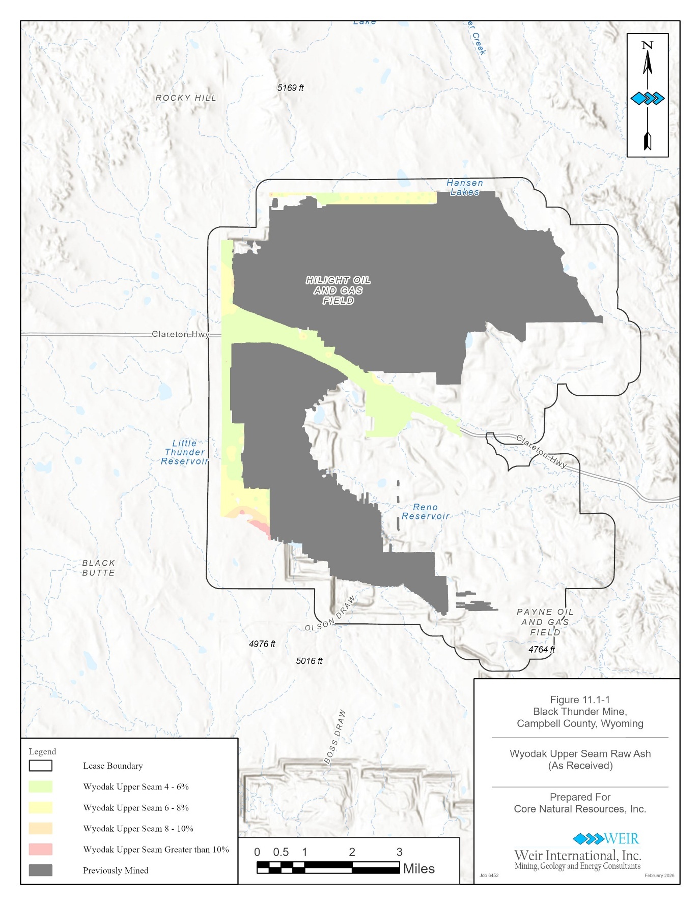
Figure 11.1-1 Wyodak - Upper Seam Raw Ash, as Received 50
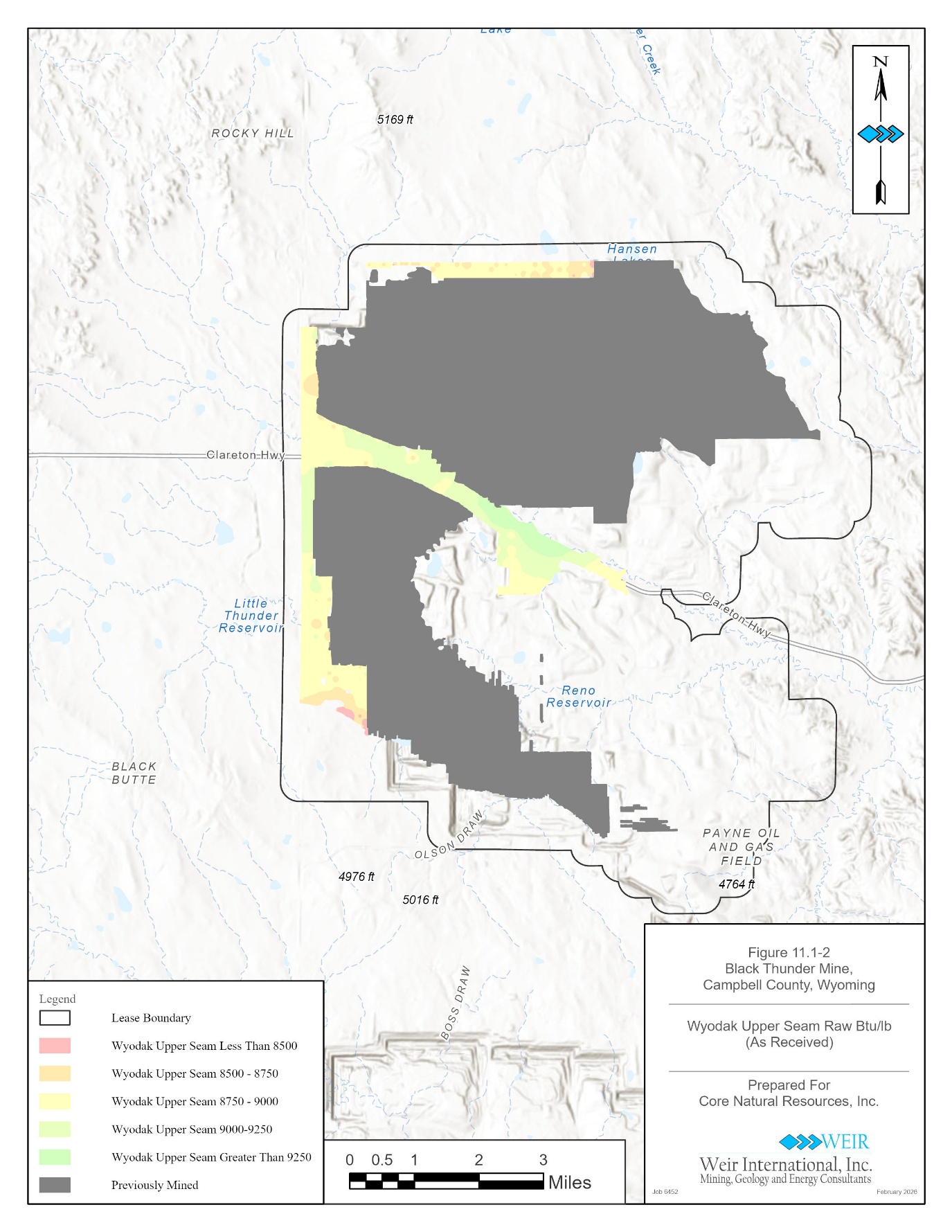
Figure 11.1-2 Wyodak - Upper Seam Raw BTU, as Received 51
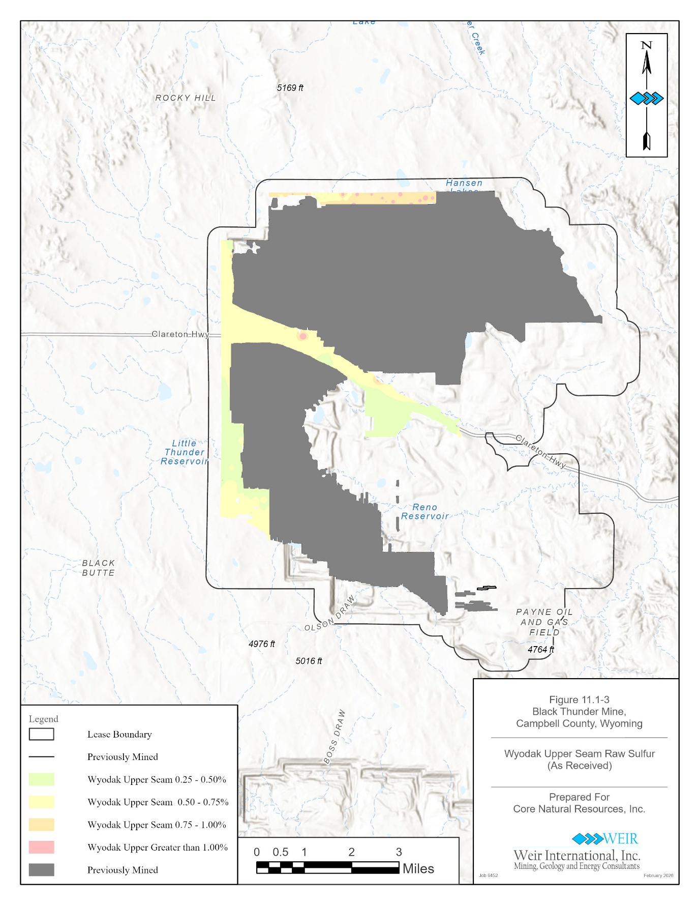
Figure 11.1-3 Wyodak - Upper Seam Raw Sulfur, as Received 52
Figure 11.1-4 Wyodak - Main Seam Raw Ash, as Received 53
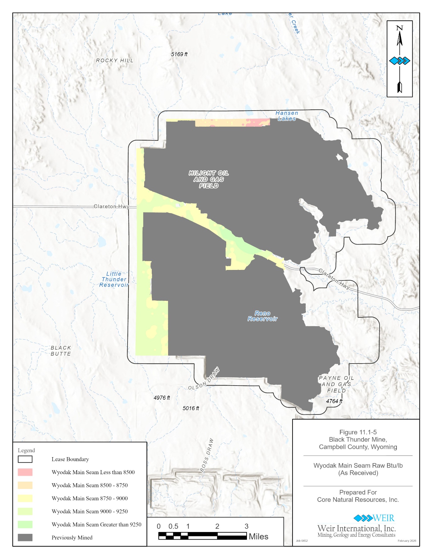
Figure 11.1-5 Wyodak - Main Seam Raw BTU, as Received 54
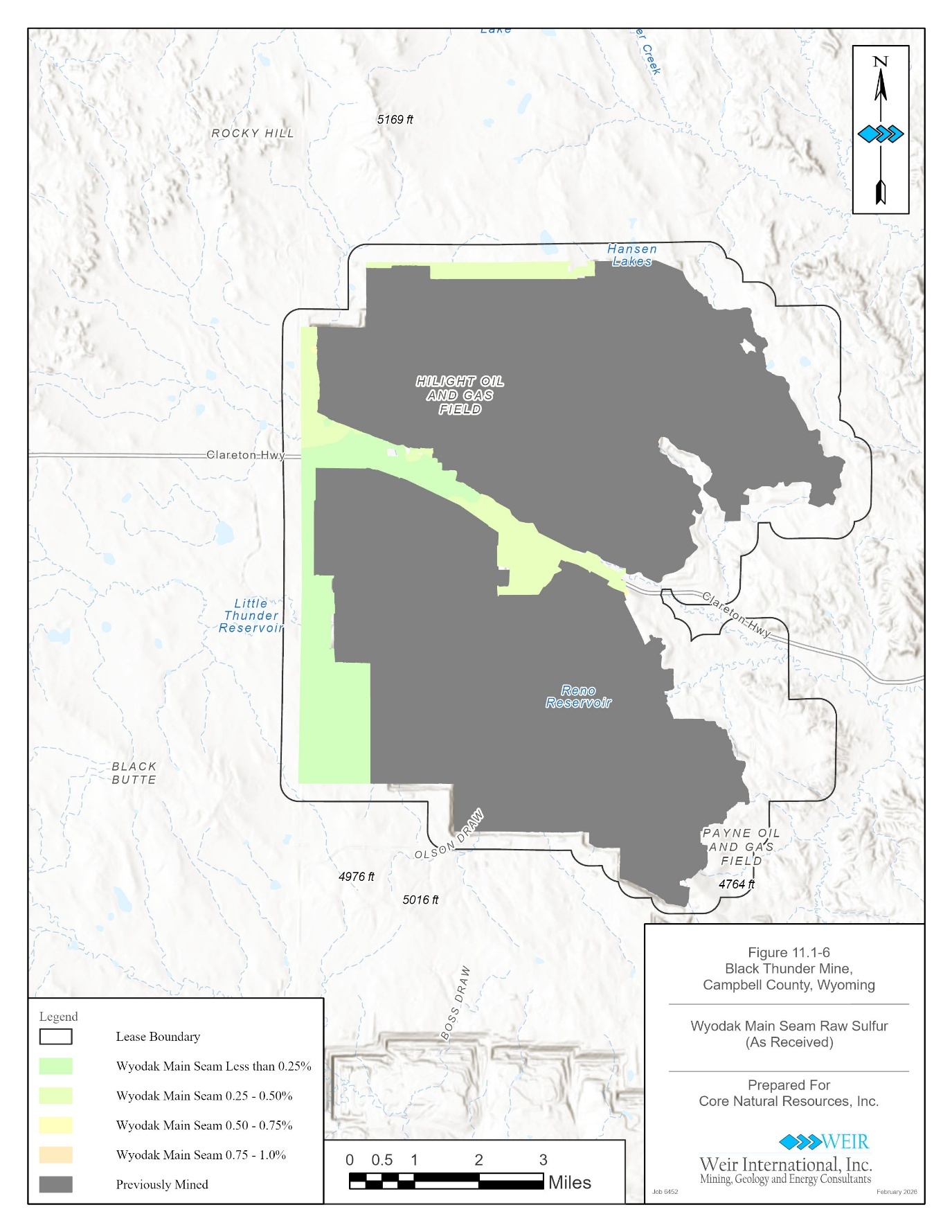
Figure 11.1-6 Wyodak - Main Seam Raw Sulfur, as Received 55
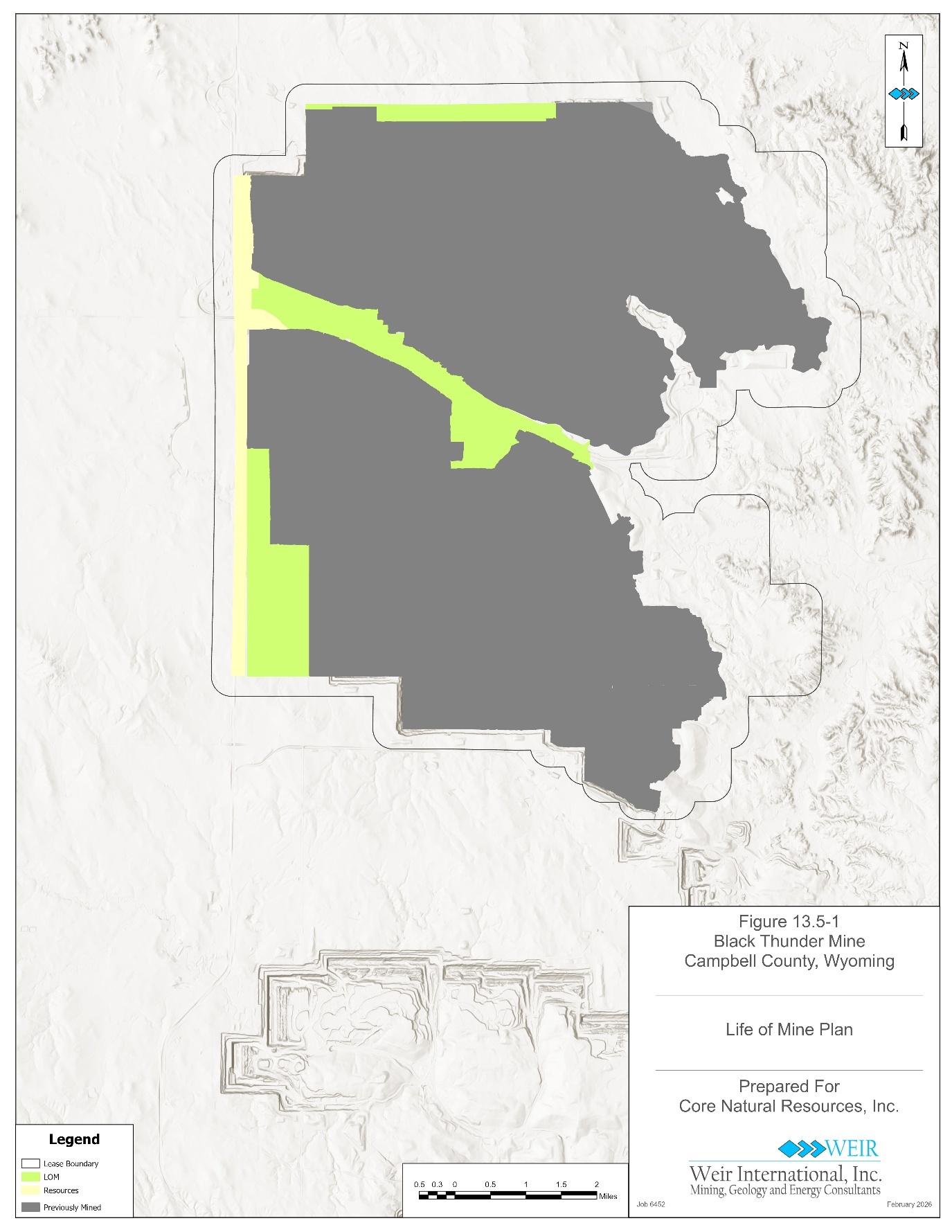
Figure 13.5-1 Life of Mine Plan 76
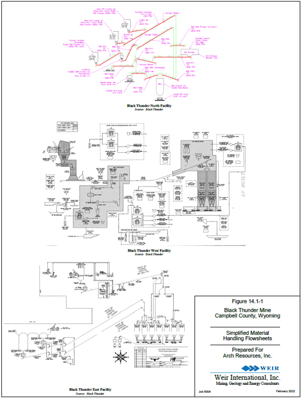
Figure 14.1-1 Simplified Material Handling Flowsheets 79
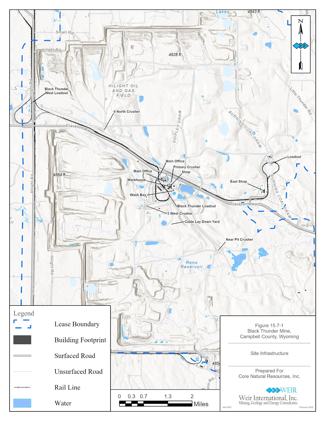
Figure 15.7-1 Mine Infrastructure 83
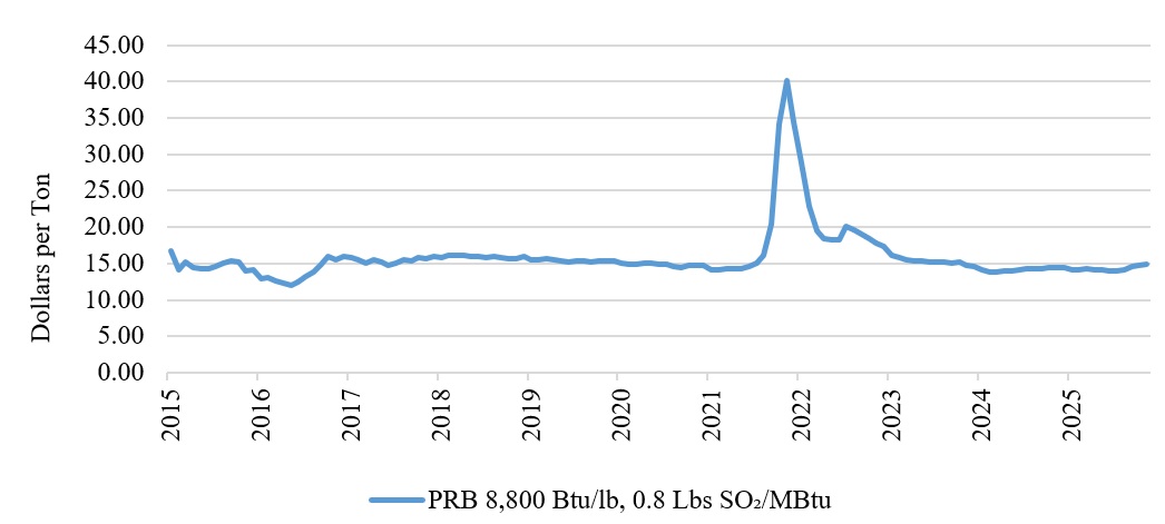
Figure 16.1-1 Historical PRB Spot Price 85
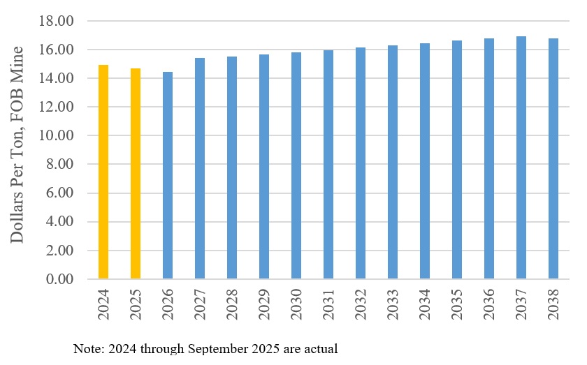
Figure 16.1-2 Historical and Projected Coal Sales Price 86
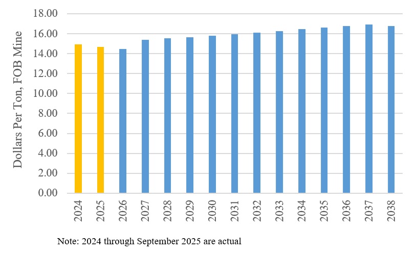
Figure 19.1-1 Black Thunder Mine Historical and Projected Coal Sales Price 100
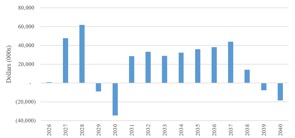
Figure 19.2-1 Annual Cash Flow Forecast 101
Figure 19.3-1 Net Present Value Sensitivity Analysis 103
February 9, 2026
viii
Weir Technical Report Summary
Black Thunder Mine
Prepared for Core Resources, Inc.
TABLES
Table 1.5-1 In-Place Coal Resource Tonnage and Quality Estimate, as of December 31, 2025 6
Table 1.5-2 Recoverable Coal Reserve Tonnage and Quality Estimate, as of December 31, 2025 7
Table 1.6-1 Key Operating Statistics 8
Table 1.7-1 Black Thunder Mining and NPDES Permits 9
Table 1.7-2 Black Thunder Permitted Area, Reclamation Liability, and Bonds 9
Table 3.3-1 Property Control 17
Table 3.4-1 Mineral Control 18
Table 3.5-1 Permit List 18
Table 11.1-1 Stratigraphic Model Interpolators 47
Table 11.1-2 Drillhole Statistics 48
Table 11.2-1 In-Place Coal Resource Tonnage and Quality Estimate, as of December 31, 2025 56
Table 11.4-1 Theoretical Variogram Ranges 58
Table 12.2-1 Recoverable Coal Reserve Tonnage and Quality Estimate as of December 31, 2021 63
Table 12.2-2 Reserve Validation 64
Table 12.5-1 Average Reserve Quality 65
Table 13.2-1 Black Thunder Mine Historical Saleable Tons Produced 69
Table 13.2-2 Black Thunder Mine LOM Plan Projected Saleable Tons Produced 70
Table 13.4-1 Mining Equipment 74
Table 13.4-2 Black Thunder Mine Safety Statistics 75
Table 17.3-1 Black Thunder Mining and NPDES Permits 92
Table 17.3-2 Black Thunder Mine Permitted Area, Reclamation Liability, and Bonds 93
Table 17.6-1 Environmental Achievements 94
Table 18.1-1 Historical and Projected LOM Plan Capital Expenditures 96
Table 18.2-1 Black Thunder Mine Historical and LOM Plan Operating Costs 97
Table 19.2-1 After-Tax NPV, IRR, Cumulative Cash Flow, and ROI 101
Table 19.2-2 Key Operating Statistics 102
Table 22.2-1 Black Thunder Mine Risk Assessment Summary 107
Table 25.1 Information Relied Upon from Registrant 111
February 9, 2026
ix
Weir Technical Report Summary
Black Thunder Mine
Prepared for Core Resources, Inc.
1.0 EXECUTIVE SUMMARY
WEIR was retained by Core Natural Resources, Inc. (Core) to prepare a Technical Report Summary (TRS) related to Core’s Black Thunder Mine (Black Thunder). This report has been prepared in accordance with the United States Securities and Exchange Commission (SEC), Regulation S-K 1300 for Mining Property Disclosure (S-K 1300) and Title 17 Code of Federal Regulations (CFR) §229.601(b)(96)(iii)(B) reporting requirements.
Core (NYSE: CNR) is a world-class producer of high-quality metallurgical coal and high calorific value thermal coal for the domestic and globally traded markets. Core’s highly skilled workforce operates a best-in-sector portfolio of large-scale, low-cost longwall mines, including the Pennsylvania Mining Complex, Leer, Leer South, and West Elk mines, along with one of the world’s largest and most productive surface mines, Black Thunder. The company plays an essential role in meeting the world’s growing need for steel, infrastructure, and energy, while simultaneously serving the resurgent requirements of the United States power generation fleet. Core has an extensive and strategic logistical network, anchored by ownership positions in two East Coast marine export terminals, that provide reliable and efficient access to seaborne markets. The company’s deeply ingrained culture is grounded in safety and compliance, continuous improvement, and financial performance, with an emphasis on stakeholder engagement and shareholder returns. Core was created in January 2025 via the merger of CONSOL Energy Inc. (CONSOL) and Arch Resources, Inc. (Arch) and is based in Canonsburg, Pennsylvania.
February 9, 2026
1
Weir Technical Report Summary
Black Thunder Mine
Prepared for Core Resources, Inc.
1.1PROPERTY DESCRIPTION
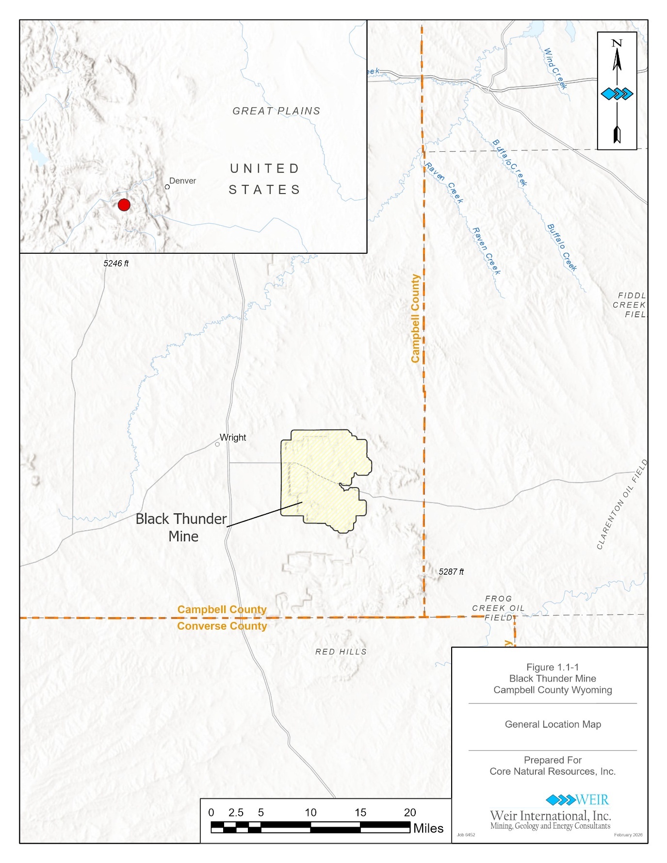
Black Thunder is located approximately 50 miles south of Gillette, in Campbell County, Wyoming. It is developed within the Powder River Basin (PRB) coal producing region of the United States (see Figure 1.1-1).
Black Thunder’s permit and reserve boundary area includes approximately 62,100 acres of controlled mineral property. Within that boundary, Core controls the Upper and Main splits of the Wyodak Seam through 17 coal leases.
February 9, 2026
2
Weir Technical Report Summary
Black Thunder Mine
Prepared for Core Resources, Inc.
Figure 1.1-1 General Location Map
February 9, 2026
3
Weir Technical Report Summary
Black Thunder Mine
Prepared for Core Resources, Inc.
1.2 GEOLOGICAL SETTING AND MINERALIZATION
The Powder River Coal Basin (PRB) of northeastern Wyoming lies entirely within the boundaries of the Powder River structural and topographic basin. Coal-bearing strata range in age from Upper Cretaceous in the Mesa Verde Formation to Eocene in the Wasatch Formation. The PRB covers parts of Campbell, Converse, Crook, Natrona, Niobrara, Johnson, and Weston Counties and is the largest coal basin in Wyoming.
The economically mineable coal in Campbell County occurs within the Tongue River Member of the Fort Union Formation. The Wyodak coal seam occurs at the top of the Fort Union Formation and is overlain by the Wasatch Formation. The coal is low sulfur, low ash, and is subbituminous C in rank. Surface mineable coal deposits occur along the north-northwesterly striking subcrop of the Wyodak coal seam. The coal seam subcrops on the eastern edge of the lease and dips approximately two to three degrees to the west, with some slight rolling. This seam contains multiple benches or plys of coal of variable thickness, although in some local areas, it becomes one seam that reaches a thickness in excess of 100 feet. Across the permit area, the Wyodak Seam ranges in thickness from 10 feet to 100 feet, averaging approximately 70 feet.
1.3 EXPLORATION
Core’s exploration activities exclusively involve drilling performed by competent contract drilling companies. Exploration drilling at Black Thunder has been a two-stage approach. Initial spot core drilling is conducted on a one-half mile grid pattern in order to delineate potential lease areas. Once the area has been leased, exploration drilling is conducted three to five years in advance of pit development. Development drilling is generally conducted on a 500 feet north/south grid, with alternating rotary and spot core holes, in conjunction with dewatering endeavors. This arrangement results in a seam geometry data spacing of 500 feet and a coal quality data spacing of 1,000 feet. Drilling is conducted with rotary table drill rigs capable of drilling to depths of 1,000 feet.
All holes are geophysically logged with a standard coal suite tool consisting of gamma, density, caliper, and resistivity.
Coal sampling for the Upper split of the Wyodak Seam is in 1.0 foot increments for the top and bottom of the seam, and evenly proportioned samples of 5 to 10 feet for the remainder of the seam. Sampling for the Main split of the Wyodak Seam is in 1.5 feet increments for the
February 9, 2026
4
Weir Technical Report Summary
Black Thunder Mine
Prepared for Core Resources, Inc.
top and bottom of the seam and 10 feet increments for the remainder of the seam. All partings encountered, down to a thickness of 0.4 foot, are sampled separately.
A hole with significant lost core or crushed core can result in misleading data. Drillholes with core recovery of less than 90 percent are noted and subsequently reviewed, and potentially excluded from geological and coal quality modeling. WEIR did not exclude any holes for poor core recovery, as all of the drillholes within the Black Thunder permit area attained core recovery of at least 90 percent.
WEIR finds the planning, implementation and supervision of Core’s drilling programs, with all data derived from the drilling programs, to be consistent with industry standards, and sufficient and relevant for use in the estimation of reserves and resources.
1.4 DEVELOPMENT AND OPERATIONS
The mining method at Black Thunder is surface mining utilizing draglines and truck/shovel mining equipment. The surface mining method has been successfully utilized in the PRB since the 1970s, and in other coal producing regions of the United States.
Black Thunder is mining the Upper and Main splits of the Wyodak Seam, and parting interval within the seam, utilizing draglines, shovels, front-end loaders, trucks, and dozers or scrapers.
Historical coal production from the Black Thunder Mine is summarized as follows:
•60.6 million tons in 2023
•44.5 million tons in 2024
•35.1 million tons in 2025 September YTD
The Black Thunder Life of Mine (LOM) Plan projects mining through 2038 with an expected mine life of 13 years. The LOM Plan projects mining from four pits at Black Thunder; the North, Northeast, West, and South pits.
Black Thunder currently operates a fleet of five draglines and 10 shovels for overburden removal, and four shovels for coal removal from the four pits. The pits will typically be 200 to 230 feet wide, with pit lengths ranging from 2,600 feet to 9,800 feet in the LOM Plan. The typical pit configuration is an initial truck/shovel pass(s) for prestrip, since the draglines
February 9, 2026
5
Weir Technical Report Summary
Black Thunder Mine
Prepared for Core Resources, Inc.
cannot effectively handle the total burden. Cast blasting is normally implemented in the next pass prior to the dragline pass, with this pass sequence requiring significant dozer material handling utilizing Black Thunder’s remote control dozer fleet. Subsequently, the dragline handles the quantity of material for which it was designed, in the next pass. The dragline performs multiple passes typically using a modified extended bench, which results in a spoil-side pass before the main split of the Wyodak Seam is mined.
Mining progresses in an orderly and sequential fashion to meet required sales tonnage and coal quality. The current mining sequence south of State Highway 450 progresses in an east to west direction. North of State Highway 450, mining advances from south to north. Recovery of coal beneath the existing rail spurs, mine facilities, and State Highway 450 is deferred to the later years of the LOM Plan in order to utilize the existing surface facilities for as long as possible.
1.5 MINERAL RESERVE AND RESOURCE ESTIMATE
Black Thunder mineral resources, as of December 31, 2025, are reported as in-place resources and are exclusive of reported coal reserve tons. Resources are reported in categories of Measured, Indicated and Inferred tonnage in accordance with Regulation S-K Item 1302(d), and summarized in Table 1.5-1 as follows:
Table 1.5-1 In-Place Coal Resource Tonnage and Quality Estimate, as of December 31, 2025
Raw Coal Quality (As Received)
Average Coal
Average
Calorific
Area
Thickness
In-Place Resources (000 Tons)
Stripping Ratio
Ash
Sulfur
Volatile
Value
Seam
(Acres)
(Feet)
Measured
Indicated
Total
(BCY/T)
(%)
(%)
Matter
(Btu/lb)
WYODAK - Upper
1,200
13.49
25,000
—
25,000
—
5.1
0.55
33.1
8,950
WYODAK - Main
1,375
73.12
175,000
5,000
180,000
—
4.0
0.23
31.9
8,990
200,000
5,000
205,000
4:1
4.1
0.27
32.0
8,980
Notes:
•Mineral Resources reported above are not Mineral Reserves and do not meet the threshold for reserve modifying factors, such as estimated economic viability, that would allow for conversion to mineral reserves. There is no certainty that any part of the Mineral Resources estimated will be converted into Mineral Reserves. Mineral Resources reported here are exclusive of Mineral Reserves.
•Resources stated as contained within a potentially economically mineable surface mine assuming a thermal coal product realizing a sales price of $15.77 per ton FOB Mine and operating cost of $14.56 per ton
•Numbers in the table have been rounded to reflect the accuracy of the estimate and may not sum due to rounding
The conversion of resources to reserves at Black Thunder considers the effects of projected dilution and loss of product coal quality, projected mineral prices and operating costs,
February 9, 2026
6
Weir Technical Report Summary
Black Thunder Mine
Prepared for Core Resources, Inc.
regulatory compliance requirements, and mineral control to determine if the saleable coal product will be economically mineable. The design of an executable mine plan that accommodates the planned mining equipment and provides a safe work environment is also considered.
The coal reserve tonnage representing the economically viable tonnage controlled by Core, and estimated in accordance with Regulation S-K Item 1302(e), is summarized in Table 1.5-2 as follows:
Table 1.5-2 Recoverable Coal Reserve Tonnage and Quality Estimate, as of December 31, 2025
Average
Raw Coal Quality (As Received)
Coal
Saleable Tons (000)
Average
Calorific
Area
Thickness
(As Received) Reserves
Stripping Ratio
Moisture
Ash
Sulfur
Volatile
Value
Seam
Product Quality
(Acres)
(Feet)
Proven
Probable
Total
(BCY/T)
(%)
(%)
(%)
Matter
(Btu/lb)
WYODAK - Upper
Subbituminous
3,700
12.7
32,000
—
32,000
—
25.8
6.1
0.65
33.1
8,890
WYODAK - Main
Subbituminous
4,590
71.8
297,500
2,000
299,500
—
25.8
4.6
0.26
32.0
8,910
329,500
2,000
331,500
3.5:1
25.8
4.8
0.30
31.9
8,910
Notes:
•Raw recoverable Reserve tonnage based on mining recovery of 85 percent for surface mining the Upper split of the Wyodak Seam, and 92 percent for surface mining the Main split of the Wyodak Seam.
•Mineral Reserves estimated at a sales price of $15.77 per ton FOB Mine and operating cost of $14.57 per ton
•Numbers in the table have been rounded to reflect the accuracy of the estimate and may not sum due to rounding
•Mineral Reserves are reported exclusive of Mineral Resources
WEIR depleted LOM Plan reserve tonnage using actual mine workings through October 31, 2025 and subtracted actual production, reported by Core, for the remainder of the year to arrive at reserves as of December 31, 2025.
1.6 ECONOMIC EVALUATION
WEIR prepared a Preliminary Feasibility Study (PFS) financial model in order to assess the economic viability of the Black Thunder LOM Plan. Specifically, plans were evaluated using discounted cash flow analysis, which consists of annual revenue projections for the Black Thunder LOM Plan. Cash outflows such as capital, including preproduction costs, sustaining capital costs, operating costs, transportation costs, royalties, and taxes are subtracted from the inflows to produce the annual cash flow projections. No adjustments are made for inflation and all cash flows are in 2025 United States dollars. WEIR’s study was conducted on an un-
February 9, 2026
7
Weir Technical Report Summary
Black Thunder Mine
Prepared for Core Resources, Inc.
levered basis, excluding costs associated with any debt servicing requirements. In its assessment of Net Present Value (NPV), WEIR utilized a discount rate of 12.5 percent.
The PFS financial model developed for use in this TRS was meant to evaluate the prospects of economic extraction of coal within the Black Thunder resource area. This economic evaluation is not meant to represent a project valuation. Furthermore, optimization of the LOM Plan was outside of the scope of this engagement.
The results of WEIR’s PFS demonstrated an after-tax NPV of $96.1 million for the Black Thunder LOM Plan. Key operational statistics for the LOM Plan, on an after-tax basis, are summarized in Table 1.6-1 as follows:
Table 1.6-1 Key Operating Statistics
LOM Plan
Clean Tons Produced (000s)
331,500
Marketable Tons Sold (000s)
331,548
($ Per Ton)
Coal Sales Realization
15.77
Cash Costs
14.65
Non-cash Costs
0.76
Total Cost of Sales
15.41
Profit / (Loss)
0.36
EBITDA
1.12
CAPEX
0.37
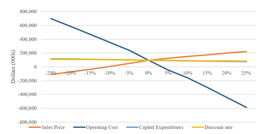
A sensitivity analysis was undertaken to examine the influence of changes to assumptions for coal sales price, operating cost, capital expenditures, and discount rate on the base case after-tax NPV. The sensitivity analysis range (±25 percent) was designed to capture the bounds of reasonable variability for each element analyzed.
The Black Thunder NPV is most sensitive to changes in coal sales price and operating cost. It is least sensitive to changes in discount rate and capital expenditures.
1.7 ENVIRONMENTAL STUDIES AND PERMITTING REQUIREMENTS
As part of the permitting process required by the Wyoming Department of Environmental Quality (DEQ), numerous baseline studies and impact assessments were undertaken by Core.
February 9, 2026
8
Weir Technical Report Summary
Black Thunder Mine
Prepared for Core Resources, Inc.
These baseline studies and impact assessments included in the permit are summarized as follows:
•Groundwater Inventory
•Surface Water Quality and Quantity
•Probable Hydrologic Consequences
Black Thunder has been issued mining permits and associated National Pollutant Discharge Elimination System (NPDES) permits by the DEQ as shown in Table 1.7-1 as follows:
Table 1.7-1 Black Thunder Mining and NPDES Permits
Permitted
Surface
Permit
Area
Issue
NPDES
Number
(Acres)
Date
Permit No.
233
62,066.12
12/3/1974
WY0024091
The permitted area, bond amounts and reclamation liability for Permit No. 233 is shown in Table 1.7-2 as follows:
Table 1.7-2 Black Thunder Permitted Area, Reclamation Liability, and Bonds
Permitted
Surface
Reclamation
Bond
Permit
Area
Liability (1)
Amount
Number
(Acres)
($000)
($000)
233
62,066
269,050
414,700
(1) Represents the undiscounted cash flows to satisfy
reclamation as of December 2025
Core currently employs approximately 650 to 750 personnel at Black Thunder. The mine also creates substantial economic value with its third-party service and supply providers, utilities and through payment of taxes and fees to governmental agencies.
Permit No. 233 has not been cited for any permit violations since 2014, which is exceptional for a coal mining operation the size of Black Thunder. Permit No. 233 was renewed in February 2025.
Based on WEIR’s review of Core’s plans for environmental compliance, permit compliance and conditions, and dealings with local individuals and groups, Core’s efforts are adequate
February 9, 2026
9
Weir Technical Report Summary
Black Thunder Mine
Prepared for Core Resources, Inc.
and reasonable in order to obtain approvals necessary relative to the execution of the Black Thunder LOM Plan.
1.8 CONCLUSIONS AND RECOMMENDATIONS
Core has a long operating history of resource exploration, mine development, and mining operations at Black Thunder, with extensive exploration data utilizing drillholes, supporting the determination of mineral resource and reserve estimates, and projected economic viability. The data has been reviewed and analyzed by WEIR and determined to be adequate in quantity and reliability to support the coal resource and coal reserve estimates in this TRS.
The coal resource and coal reserve estimates and supporting PFS were prepared in accordance with Regulation S-K 1300 requirements. There are 205.0 million in-place tons of measured and indicated mineral resources, exclusive of reserves, and 331.5 million clean recoverable tons of surface mineable reserves within the Black Thunder property as of December 31, 2025. Reasonable prospects for economic extraction were established through the development of a PFS relative to the Black Thunder LOM Plan, considering historical mining performance, historical and projected thermal coal sales prices, historical and projected mine operating costs, and recognizing reasonable and sufficient capital expenditures.
The ability of Core, or any coal company, to achieve production and financial projections is dependent on numerous factors. These factors primarily include site-specific geological conditions, the capabilities of management and mine personnel, level of success in acquiring reserves and surface properties, coal sales prices and market conditions, environmental issues, securing permits and bonds, and developing and operating mines in a safe and efficient manner. Unforeseen changes in legislation and new industry developments could substantially alter the performance of any mining company.
Coal mining is carried out in an environment where not all events are predictable. While an effective management team can identify known risks and take measures to manage and/or mitigate these risks, there is still the possibility of unexpected and unpredictable events occurring. It is not possible therefore to totally remove all risks or state with certainty that an event that may have a material impact on the operation of a coal mine will not occur.
February 9, 2026
10
Weir Technical Report Summary
Black Thunder Mine
Prepared for Core Resources, Inc.
WEIR assessed risks associated with the economic mineability of Black Thunder to be low to moderate and adds that the majority of the risks can be kept low and/or mitigated with proper planning and monitoring of the mining operations.
WEIR recommends that any future exploration work and mineral property acquisition should include what has been historically implemented related to the following:
Geology
•Have an experienced geologist log core holes, measure core recovery, complete sampling. Geophysically log core holes to verify seam and coal thickness and core recovery.
•Geophysically log rotary holes to verify strata and coal thickness.
•Continue to prepare laboratory analysis of any core hole samples.
Mine Plan
•Continue to monitor the results of the dewatering wells to minimize groundwater flows and adverse impact on highwall stability.
February 9, 2026
11
Weir Technical Report Summary
Black Thunder Mine
Prepared for Core Resources, Inc.
2.0 INTRODUCTION
2.1 REGISTRANT
WEIR was retained by Core (NYSE: CNR) to prepare the Black Thunder TRS related to Core’s currently operating Black Thunder mining operation. Black Thunder is located approximately 50 miles south of Gillette, Wyoming, in Campbell County within the PRB coal producing region of the United States (see Figure 1.1-1).
2.2 TERMS OF REFERENCE AND PURPOSE
This TRS was prepared specifically for Core’s Black Thunder mining operations. The Upper and Main splits of the Wyodak Seam resources at Black Thunder have been classified in accordance with SEC mining property disclosure rules under Subpart 1300 and Item 601 (96)(B)(iii) of Regulation S-K. Unless otherwise stated, all volumes, grades, distances, and currencies are expressed in United States customary units.
The accuracy of reserve and resource estimates are, in part, a function of the quality and quantity of available data at the time this report was prepared. Estimates presented herein are considered reasonable. However, estimates should be accepted with the understanding that with additional data and analysis subsequent to the date of this report, the estimates may necessitate revision which may be material. Certain information set forth in this report contains “forward-looking information”, including production, productivity, operating costs, capital costs, sales prices, and other assumptions. These statements are not guarantees of future performance and undue reliance should not be placed on this information. The assumptions used to develop the forward-looking information and the risks that could cause the actual results to differ materially are detailed in the body of this report.
Black Thunder is a permitted surface mine that commenced production of thermal coal in the fourth quarter of 1977.
For Black Thunder, as an established producing mine, this TRS reports both mineral reserves and resources (exclusive of reserves). Supporting the assessment of the economic mineability of reported reserves and prospects of economically feasible extraction of reported resources, this report includes summary detail of a PFS conducted relative to Black Thunder.
February 9, 2026
12
Weir Technical Report Summary
Black Thunder Mine
Prepared for Core Resources, Inc.
WEIR’s evaluation of Core’s mineral reserves and resources was conducted in accordance with SEC S-K 1300 definitions for Mineral Resource, Mineral Reserve and Preliminary Feasibility Study as follows:
•Mineral Resource is a concentration or occurrence of material of economic interest in or on the earth’s crust in such form, grade or quality, and quantity that there are reasonable prospects for economic extraction. A mineral resource is a reasonable estimate of mineralization, taking into account relevant factors such as cut-off grade, likely mining dimensions, location or continuity, that, with the assumed and justifiable technical and economic conditions, is likely to, in whole or in part, become economically extractable. It is not merely an inventory of all mineralization drilled or sampled.
•Mineral Reserve is an estimate of tonnage and grade or quality of indicated and measured mineral resources that, in the opinion of the QP, can be the basis of an economically viable project. More specifically, it is the economically mineable part of a measured or indicated mineral resource, which includes diluting materials and allowances for losses that may occur when the material is mined or extracted.
•Preliminary Feasibility Study is a comprehensive study of a range of options for the technical and economic viability of a mineral project that has advanced to a stage where a QP has determined (in the case of underground mining) a preferred mining method, or (in the case of surface mining) a pit configuration, and in all cases has determined an effective method of mineral processing and an effective plan to sell the product.
2.3 SOURCES OF INFORMATION AND DATA
The primary information evaluated for this study, including but not limited to maps, plans, schematics, drawings, and discussions, was as follows:
•Geological data that was exclusively provided by Core geology and engineering staff. The geological data includes drillhole information such as driller’s logs, geologist’s logs, both full and partial scans of geophysical logs, survey data, coal quality laboratory certificates, and MS Excel™ (Excel) versions of drillhole survey, lithology, and quality data. Additionally, WEIR was provided with modelled coal seam floor elevations and seam thickness contours, topography contours, and other base geological data.
February 9, 2026
13
Weir Technical Report Summary
Black Thunder Mine
Prepared for Core Resources, Inc.
•Mineral and surface ownership maps, and supplemental files were provided exclusively by Core Land LLC, a subsidiary of Core.
•Site visits by WEIR QPs on March 18, 2025.
•Interviews between WEIR personnel and Core personnel including;
President of Wyoming Operations
Vice President of Geology & Exploration
Director of Financial Analysis and Support
Engineering Manager
Senior Engineer
Senior Geologist
•Historical production, productivity, staffing levels, operating costs, capital expenditures, and coal sales revenue provided by Core.
•LOM projections and cost model provided by Core.
•Health, safety, and environmental issues discussed during interviews between WEIR personnel and Core personnel.
•Current mine permits, in addition to recent permit revisions and renewals provided by Core.
•Current and projected mine plans, including production, productivity, operating costs, and capital expenditures required to sustain projected levels of production for Black Thunder, provided by Core, and which were all reviewed for reasonableness by WEIR.
•Market outlook and coal sales price projections provided by Core
•Projected reclamation costs for mine closure activities provided by Core.
A detailed list of all data received and reviewed for this study is provided in Sections 24.0 and 25.0 of this TRS.
2.4 DETAILS OF THE PERSONAL INSPECTION OF THE PROPERTY
WEIR’s QPs previously visited Black Thunder on August 19, 2021. WEIR has also performed numerous annual audits of Black Thunder reserves for Arch Resources, Inc. annual SEC 10-K filings.
WEIR’s QPs held discussions with Black Thunder personnel on March 18, 2025, to review questions relative to Black Thunder’s geology, mine plans and operations, the management discussions included key topics as follows:
February 9, 2026
14
Weir Technical Report Summary
Black Thunder Mine
Prepared for Core Resources, Inc.
•Geology
•Property
•Infrastructure
•Mine Plan, Production and Productivity
•Operating Costs and Capital Expenditures
•Marketing
•Environmental and Compliance
•Risks and Uncertainties
Subsequently, WEIR’s mining QP visited the Black Thunder Mine on March 18, 2025. Areas of the mine visited included the following:
•Mine Office and bathhouse
•Warehouse
•Stockpiles
•Rail Loadout
•North, Northeast, South, and West Pits
In addition to observance of mine infrastructure, surface facilities and mining conditions, WEIR discussed Black Thunder LOM Plan with mine management personnel.
2.5 PREVIOUS TRS
This TRS is an update to the first Black Thunder TRS prepared by WEIR, dated February 10, 2021, which was prepared for Arch Resources, Inc. The previous TRS was completed before the merger of Arch Resources, Inc. and CONSOL Energy, Inc.
February 9, 2026
15
Weir Technical Report Summary
Black Thunder Mine
Prepared for Core Resources, Inc.
3.0 PROPERTY DESCRIPTION
3.1 PROPERTY LOCATION
Black Thunder is located approximately 50 miles south of Gillette, Wyoming in Campbell County, within the PRB coal producing region of the United States (see Figure 1.1-1). The approximate location Black Thunder is 43 42’ 00” N Latitude 105 17’ 30” W Longitude. The United States Geological Survey (USGS) 7.5-minute quadrangle map sheets, upon which Black Thunder can be found, are Hilight, Open A Ranch, Reno Reservoir, Piney Canyon NW, Teckla and Piney Canyon SW.
3.2 PROPERTY AREA
The Black Thunder permit area and reserve boundary includes approximately 62,100 acres of controlled mineral property.
The Black Thunder surface facilities are located within the Black Thunder permit area, near the central area of the north boundary of the permit. The surface facilities include mine administration, engineering, and operations offices, mine roads, laydown areas, ponds, crushers, rail loadouts, mine maintenance facilities, warehouse facilities, and parking lots. The disturbed area for Black Thunder surface facilities is approximately 3,230 acres. The coal, backfill, and topsoil stockpiles represent approximately 5,300 additional acres of disturbed area.
3.3 PROPERTY CONTROL
Within Black Thunder’s permit and reserve boundary, Core controls the Upper and Main splits of the Wyodak Seam through 17 coal leases covering approximately 62,100 acres, described in Table 3.4-1. Table 3.3-1 describes the various property control contracts.
February 9, 2026
16
Weir Technical Report Summary
Black Thunder Mine
Prepared for Core Resources, Inc.
Table 3.3-1 Property Control
Document Type
Quantity
Agreements
19
Grazing Lease
2
Coal Leases
2
Federal Coal Leases
6
State Coal Leases
9
Deeds
26
Overstrip Agreement
3
Surface Rights
1
Water Rights
13
Each individual contract shown above may include more than one type of property control.
3.4 MINERAL CONTROL
Coal seam mineral rights are controlled by two coal leases, six federal leases, and nine state leases. All but two leases have minimum annual rental payments ranging from $480 to $18,225. All of the leases have a production royalty rate of 12.5 percent of the Gross Sales Price (GSP). The leases have a minimum royalty that must be paid annually in order to maintain the lease, with the exception of one lease, which has a one-time minimum royalty payment. Three leases have additional annual rental agreements. Federal legislation signed in July 2024 significantly reduced the Federal coal royalty rate from 12.5 percent to 7 percent, effective July 2024 through September 2034. The details of the mineral control contracts are listed in Table 3.4-1.
February 9, 2026
17
Weir Technical Report Summary
Black Thunder Mine
Prepared for Core Resources, Inc.
Table 3.4-1 Mineral Control
Core
Document
Expiration
File Number
Type
Seams
Date
FCL-001
Federal Coal Lease
All seams leased
Upon Exhaustion
FCL-002
Federal Coal Lease
All seams leased
Upon Exhaustion
C-1
Coal Lease
All seams leased
Upon Exhaustion
SCL-001
State Coal Lease
All seams leased
Upon Exhaustion
SCL-002
State Coal Lease
All seams leased
Upon Exhaustion
SCL-003
State Coal Lease
All seams leased
Upon Exhaustion
SCL-004
State Coal Lease
All seams leased
Upon Exhaustion
SCL-005
State Coal Lease
All seams leased
Upon Exhaustion
FCL-003
Federal Coal Lease
All seams leased
Upon Exhaustion
SCL-006
State Coal Lease
All seams leased
Upon Exhaustion
CL-2
Coal Lease Agreement
All seams leased
Upon Exhaustion
FCL-004
Federal Coal Lease
All seams leased
Upon Exhaustion
FCL-005
Federal Coal Lease
All seams leased Surface mineable coal reserves in the Wyodak-Anderson coal zone. Generally contains two recoverable seams, the Upper Wyodak and the Middle Wyodak.
Upon Exhaustion
FCL-006
Federal Coal Lease
All seams leased
Upon Exhaustion
SCL-007
State Coal Lease
All seams leased
Upon Exhaustion
SCL-008
State Coal Lease
All seams leased
Upon Exhaustion
SCL-009
State Coal Lease
All seams leased
Upon Exhaustion
3.5 SIGNIFICANT PROPERTY ENCUMBRANCES
The Black Thunder LOM Plan area is permitted with the Wyoming DEQ, Land Quality Division (LQD).
Black Thunder’s mining permit and NPDES permit are shown in Table 3.5-1, with a more detailed description of the permits discussed in Section 17.3 of this TRS.
Table 3.5-1 Permit List
Permitted
Surface
Permit
Area
Issue
NPDES
Number
(Acres)
Date
Permit No.
233
62,066.12
12/3/1974
WY00224091
Since 2014, Black Thunder has not had a regulatory fine or violation from the Wyoming LQD. Permit No. 233 was renewed in February 2025.
February 9, 2026
18
Weir Technical Report Summary
Black Thunder Mine
Prepared for Core Resources, Inc.
3.6 SIGNIFICANT PROPERTY FACTORS AND RISKS
Given Core’s controlled interests at Black Thunder, which relate to property that is held, by and large, by Core and the BLM, WEIR finds there are no significant issues affecting access to the coal interests, or the ability of Core to execute the Black Thunder LOM Plan.
3.7 ROYALTY INTEREST
Core, at the Black Thunder mining operation, holds no royalty or similar interest in property that is owned or operated by another party.
February 9, 2026
19
Weir Technical Report Summary
Black Thunder Mine
Prepared for Core Resources, Inc.
4.0 ACCESSIBILITY, CLIMATE, LOCAL RESOURCES, INFRASTRUCTURE, AND PHYSIOGRAPHY
4.1 TOPOGRAPHY, ELEVATION, AND VEGETATION
The Black Thunder property is located within the eastern flank of the PRB on the Missouri Plateau of the Northern Great Plains Province. The PRB is a topographic depression between the Big Horn Mountains on the west and the Black Hills on the east. The topography of the property is comprised of rolling and rugged hills, with 500 to 1,000 feet of vertical relief in the northern part of the basin, and gentle plains, with up to 500 feet of relief in the southern part. Surface elevations range from 4,000 feet above mean sea level (MSL) in the north to 5,000 feet above MSL in the south.
Within the mine permit area, the terrain is gently rolling, except along the eastern edge of the property and to the south of Little Thunder Creek. In these two areas, the property is transected by steep-sided, irregular gullies and washes, which drain into Little Thunder Creek, forming breaks in the plateau. Elevations within the mine permit area range from approximately 4,570 feet to 5,030 feet. The surface of the mine permit area is made up of eroded shale slopes, alluvial terraces and small playas, minor sheet wash, and floodplains. Scoria (clinker) ledges occur near “burn” lines.
The Black Thunder property consists mostly of two major vegetation types. These major vegetation types are Mixed Grass Prairie (Upland Grassland) and the Big Sagebrush Shrubland.
The Mixed Grass Prairie vegetation is generally found on moderately deep to deep soils on gently rolling to flat topography. Perennial grasses are the dominant vegetative type here. Western wheatgrass (Agropyron smithii), needle-and-thread (Stipa comata), blue grama (Bouteloua gracilis), prairie Junegrass (Koeleria macrantha), Sandberg bluegrass (Poa secunda) and threadleaf sedge (Carex filifolia) are generally the most common species encountered. Cheatgrass (Bromus tectorum) is a common annual invasive species of grass that may be found during years favoring growth of this species.
The Big Sagebrush Shrubland plant community is found on a variety of soils in the area ranging from very poor and shallow to loamy and deep. This vegetation type is also found on
February 9, 2026
20
Weir Technical Report Summary
Black Thunder Mine
Prepared for Core Resources, Inc.
a wide range of topographies from very steep and rolling too relatively flat. Perennial grasses also dominate the Big Sagebrush Shrubland vegetation, but big sagebrush (Artemisia tridentata) is the single most common individual species. Other common perennial species on the Big Sagebrush Shrubland include needle-and-thread, western wheatgrass, prairie Junegrass and blue grama. Annual species such as cheatgrass may also be common on the Big Sagebrush Shrubland in certain years.
4.2 PROPERTY ACCESS
Black Thunder is accessed from Interstate 90 in Gillette, Wyoming by traveling south on Wyoming State Highway 59 for 41.0 miles, then turning east and traveling on Wyoming State Highway 450 for 9.7 miles. The mine entrance is located on the south side of the highway. The nearest town is Wright, Wyoming, which is located 1.9 miles north of Wyoming State Highway 450.
Rail transportation is provided by both the UP and BNSF railroads with the main line running directly along the west side of the mine and spurs connecting to all three load outs. There is no river transportation available near Black Thunder.
The nearest airport is the Northeast Regional Airport located along Wyoming State Highway 59/ US Highway 14 on the north side of Gillette, Wyoming. Flights are available to Rapid City Regional Airport and Denver International Airport.
4.3 CLIMATE AND OPERATING SEASON
The Black Thunder property lies on the rolling high plains of northeastern Wyoming. The property is approximately 200 miles east-northeast of the low-level Continental Divide of southeastern Wyoming, approximately 60 miles west of the Black Hills, and approximately 70 miles east of the Big Horn Mountains. Climate in the high plains of northeastern Wyoming is influenced primarily by cold, dense air masses that flow across the Continental Divide from the west and northwest. Since there are no mountains north of the high plains region, the plains are subjected to periodic outbreaks of Arctic air masses during the autumn, winter, and spring. Each outbreak causes abrupt changes in weather such as northerly winds, dropping temperatures, and snow. During the winter, cold, dense air masses originating from the Great Basin (a large basin that lies between the Sierra Nevada and Rocky Mountain ranges) frequently drain across the low-level Continental Divide through southern Wyoming
February 9, 2026
21
Weir Technical Report Summary
Black Thunder Mine
Prepared for Core Resources, Inc.
and down into the North Platte Valley. The air accelerates to higher velocities and spreads over eastern Wyoming. Some of this air moves northeastward toward Black Thunder, however, the prevailing northwesterly, westerly, and southeasterly surface wind flows observed at the mine property are due to the channeling of drainage winds between the Big Horn Mountains and the Black Hills.
The summer climate is typical for the high plains with light to moderate surface winds and occasional violent thunderstorms. The thunderstorms generate most of the annual precipitation. Wind gusts, from the occasionally severe thunderstorms, sometimes reach 60 to 80 miles per hour (mph) and may be followed by hail. The climate of northeastern Wyoming can be classified as semi-arid since mean annual precipitation is approximately 13 inches and relative humidity is rather low, being less than 50 percent on an annual average.
The mean monthly temperature recorded at Gillette 2E, a meteorological station in the vicinity of Black Thunder, ranges from 72 degrees Fahrenheit (°F) in July to 22°F in January. The average frost-free growing season is 127 days. The average last spring freeze date, recorded at Gillette, is May 21, and the average first freeze date is September 25.
Although extreme weather is experienced at Black Thunder during all seasons, there is no seasonal limitation to mining operations at Black Thunder.
4.4 INFRASTRUCTURE
Power
Electrical power for Black Thunder is provided by Powder River Energy Corporation (PREC), through a 69 kV transmission line. PREC’s average industrial price is 6.41 cents per KWH.
Water
The water used for dust suppression is obtained from the mine’s own highwall dewatering program. This dewatering program is able to produce 500 to 800 million gallons of water per year. Potable water for the facilities is obtained from two onsite deep-water wells. This water is treated at a flat rate of $3,520 per month. In 2025, Black Thunder’s average water usage was approximately 49 million gallons per month for haul road dust suppression and facilities washdown.
Personnel
February 9, 2026
22
Weir Technical Report Summary
Black Thunder Mine
Prepared for Core Resources, Inc.
The northern Wyoming area surrounding Black Thunder has a long history of surface coal mining and attracting and hiring mining personnel with qualified skills has not been an issue. Black Thunder employs approximately 650 to 750 personnel, as of November 1, 2025. The hourly labor force at Black Thunder remains non-union and no change in this labor arrangement is anticipated.
Supplies
Supplies for the Black Thunder mining operation are available from multiple vendors that service the coal mining industry in the PRB Region. The nearest Caterpillar mining equipment dealerships are located in Gillette and Casper, Wyoming, and there is a Komatsu mining equipment dealership, located in Gillette.
February 9, 2026
23
Weir Technical Report Summary
Black Thunder Mine
Prepared for Core Resources, Inc.
5.0 HISTORY
5.1 PREVIOUS OPERATIONS
Prior to the development of Black Thunder, there was no mining that occurred on the property. Black Thunder is a surface coal mine utilizing draglines and truck/shovel mining equipment for overburden removal. The mine was opened by Atlantic Richfield Company (ARCO) in 1977 and has been operated under Thunder Basin Coal Company, LLC since that time. In 1998, Arch Coal, Inc. purchased all of ARCO’s domestic coal operations, which included the Thunder Basin Coal Company, LLC’s Black Thunder mining operation.
In 2004, Arch Coal, Inc. purchased the adjacent North Rochelle Mine from Triton Coal Company and merged it into Black Thunder Mine. The former North Rochelle Mine facilities and reserves were subsequently sold to Peabody Energy in 2006.
In 2009, Arch purchased the adjacent Jacobs Ranch Mine from Rio Tinto Coal and merged it into Black Thunder, which created a mining complex that produced 116.2 million tons of coal in 2010.
In January 2025, Arch Resources, Inc. and Consol Energy, Inc. merged to form one company Core Natural Resources, Inc.
5.2 PREVIOUS EXPLORATION AND DEVELOPMENT
Exploration work conducted by ARCO included both pre-lease, Federal Exploration License drilling and post-lease development drilling. Pre-lease drilling was generally done on a one-half mile spacing, or one hole per quarter section, which corresponded with the requirements of the BLM for leasing Federal coal. Most development drilling was done two to three years ahead of mining on a nominal 600 foot spacing with alternating rows offset one-half the spacing resulting in a 45-degree rotated grid interval of 424 feet and included over 1,500 drillholes.
Exploration work conducted by the Jacobs Ranch Mine also included both pre-lease, Federal Exploration License drilling and post-lease development drilling. Pre-lease drilling was also generally done on a one-half mile spacing, or one hole per quarter section, which corresponded with the requirements of the BLM for leasing Federal coal. Most development
February 9, 2026
24
Weir Technical Report Summary
Black Thunder Mine
Prepared for Core Resources, Inc.
drilling was done three to five years in advance of mining and was mostly done on a nominal 800 foot spacing, with alternating rows offset one-half of the spacing resulting in a 45-degree rotated grid interval of 565 feet and included over 2,600 drillholes.
Other exploration work conducted prior to Arch Coal Inc.’s acquisition included regional USGS reconnaissance drilling of unleased Federal coal, prior to ARCO’s, at a density of one to two holes per section and coalbed methane production drilling that was done on a density of anywhere between one and sixteen holes per section. The coalbed methane drillholes and most of the USGS drillholes were rotary drilled.
Mine facilities built by ARCO included a rail spur and loadout loop, a loadout with two 12,500-ton silos, a 100,000-ton slot storage barn, two crusher locations, a coal analysis lab, maintenance shop, warehouse, bathhouse, reclamation shop, and an administrative building.
Initial pit development was conducted with truck/shovel mining equipment, but ARCO subsequently added three draglines by the time the mine was acquired by Arch Coal, Inc., including a Bucyrus-Erie 1300W with a 45 cubic yard bucket, a Bucyrus-Erie 1570W with a 90 cubic yard bucket, and a Bucyrus-Erie 2570WS with a 160 cubic yard bucket.
The Jacobs Ranch Mine also constructed mine facilities similar to those constructed by ARCO, however, as time progressed and mining moved farther west, these facilities, including the loadout, have been idled.
The Jacobs Ranch Mine was historically one of the larger truck/shovel mines operating in the PRB until a Bucyrus-Erie 2570W dragline, with a 120 cubic yard bucket, was brought on-line in 2006.
February 9, 2026
25
Weir Technical Report Summary
Black Thunder Mine
Prepared for Core Resources, Inc.
6.0 GEOLOGICAL SETTING, MINERALIZATION, AND DEPOSIT
6.1 REGIONAL, LOCAL, AND PROPERTY GEOLOGY
6.1.1 Regional Geology
The Powder River Coal Basin of northeastern Wyoming lies entirely within the boundaries of the Powder River structural and topographic basin. Coal-bearing strata range in age from Upper Cretaceous in the Mesa Verde Formation to Eocene in the Wasatch Formation. The Powder River Coal Basin covers parts of Campbell, Converse, Crook, Natrona, Niobrara, Johnson, and Weston Counties and is the largest coal basin in Wyoming.
The basin is a broad asymmetric syncline bounded on the west by the Big Horn Mountains, on the east by the Black Hills, and to the south by the Casper Core, Laramie Mountains, and the Hartville Uplift. The basin continues north into Montana where the Miles City Core separates it from the Williston Basin.
The axis of the syncline is slightly west of the center of the basin. Flanking dips are gentle on the eastern limb (two to three degrees) but dip more steeply on the western limb. Faulting occurs in many localities, especially around the basin edge and is in association with folding. Vertical displacements can be several hundred feet. Faulting is more common on the western limb of the syncline than on the eastern limb.
Stratigraphic units of interest in the Black Thunder permit area, from youngest to oldest, include recent alluvial deposits, the Eocene Wasatch Formation, and the Paleocene Fort Union Formation. Locally, the strata dip two degrees to the west-southwest. There is no evidence of major faulting, or folding, within the permit area; although, localized warps and minor faults, probably compactional in nature, in the main coal seams have been indicated by exploration work and during the mining process.
An alluvial covering is present in the drainage patterns and in the slope wash areas adjacent to the drainages. The alluvial deposits are of recent age and consist of primarily unconsolidated, discontinuous lenses of clays, silts, and sands. Locally, recent stream channeling has removed portions of the coal seam with subsequent channel infilling of
February 9, 2026
26
Weir Technical Report Summary
Black Thunder Mine
Prepared for Core Resources, Inc.
sediment. Varying amounts of oxidized coal are present when alluvium is in contact with the seam.
The lower Eocene Wasatch Formation consists of interbedded, lenticular clays, silty clays, sandy clays, thin, discontinuous coals, mudstones, and dirty sandstones. Correlation of individual strata is difficult due to the discontinuous and lens-like nature of the units which is inherent in fluvial deposition, e.g., channel sand deposits.
The Upper Paleocene Fort Union Formation underlies the Wasatch Formation. The Fort Union Formation consists of non-carbonaceous to highly-carbonaceous clays, mudstones, sandstones, and coal. The top of the Fort Union Formation is designated as the top of the Wyodak Seam. The Wyodak Seam is the main coal seam, and it lies atop lensoidal clay, silt, and sand beds. The seam base is variable due to changes in the environment of deposition, from the non-coal forming environment of the sands, clays, and silts, to the fringes of the coal forming, swampy conditions in which the Wyodak Seam was deposited.
Clinker (locally known as scoria), a baked or fused rock, is present along the coal outcrop on the eastern edge of Black Thunder’s permit area. This fused material was formed by prehistoric burning of the Main Wyodak coal seam. Both the Wasatch and the Fort Union formations have been affected by this prehistoric burning and have contributed to the volume of baked material present. Mining conditions often deteriorate in proximity of these clinker deposits.
The mudstone is a uniformly textured material composed of 40 to 80 percent clay, and generally 5 to 40 percent silt; the remainder being sand. It is generally medium to dark gray with occasional brown and tan oxidized zones. The mudstone is basically soft to medium stiff with some extremely stiff waxy mudstone throughout much of the area. The mudstone contains some carbonaceous material and thin coal partings.
Sandstone is a major lithologic component of the overburden in the mine area. It is generally weakly cemented with clay, but occasionally well-cemented resistant beds are encountered. Sandstone occurs in discontinuous zones interbedded with similarly discontinuous mudstone and siltstone. It is very fine to medium grained, gray to dark gray in color, with brown and tan oxidized zones. The sandstone ranges from well-graded, poorly-sorted silty sand to clean, uniform, poorly-graded material, consisting of over 80 percent sand in some instances. Sandstone overlies the coal in some areas.
February 9, 2026
27
Weir Technical Report Summary
Black Thunder Mine
Prepared for Core Resources, Inc.
Siltstone constitutes approximately 15 percent of the overburden by volume. Like the mudstone, it is uniformly textured with 20 to 55 percent silt, and generally 20 to 60 percent clay, the remainder being sand. It is light to medium gray color and slightly more consolidated than mudstone. Like other overburden lithologic units, the siltstone is discontinuous and occurs interbedded with mudstone and sandstone, and in some areas overlies the coal.
6.1.2 Local Geology
Regionally, the most economical coal seams are contained in the Paleocene Fort Union Formation and the Eocene Wasatch Formation. Individual seams range to greater than 100 feet in thickness. Large quantities of potentially surface-mineable coal are contained in these formations.
6.1.3 Property Geology
The economically mineable coal in Campbell County occurs within the Tongue River Member of the Fort Union Formation. The Wyodak coal seam occurs at the top of the Fort Union Formation and is overlain by the Wasatch Formation. The coal is low sulfur, low ash, and is subbituminous C in rank. Surface mineable coal deposits occur along the north-northwesterly striking subcrop of the Wyodak coal seam. The coal seam subcrops on the eastern edge of the lease and dips about two to three degrees to the west, with some slight rolling. This seam contains multiple benches or plys of coal of variable thicknesses, although in some local areas, it becomes one seam that reaches a thickness in excess of 100 feet. Across the mine permit area, the Wyodak Seam ranges in thickness from 10 feet to 100 feet, averaging approximately 70 feet.
6.2 MINERAL DEPOSIT TYPE AND GEOLOGICAL MODEL
The Black Thunder reserve area is a relatively flat lying sedimentary deposit of Paleocene Age. Black Thunder is actively mining a single coal seam, the Wyodak, that can be comprised of several splits, the Upper and Main splits of the Wyodak Seam. Exploration consists of core drilling for the Upper and Main splits carried out each year in advance of mining, to refine the reserve boundary and to define limits of the mine plan. For internal purposes, Core models the reserve using the Geovia Minex® mine planning software package, completing model updates subsequent to each phase of exploration drilling. WEIR modeled the reserves and resources using Datamine MineScape® Stratmodel geological modeling software. The WEIR model is discussed in more detail in Section 9.1 of this TRS.
February 9, 2026
28
Weir Technical Report Summary
Black Thunder Mine
Prepared for Core Resources, Inc.
6.3 STRATIGRAPHIC COLUMN AND CROSS SECTION
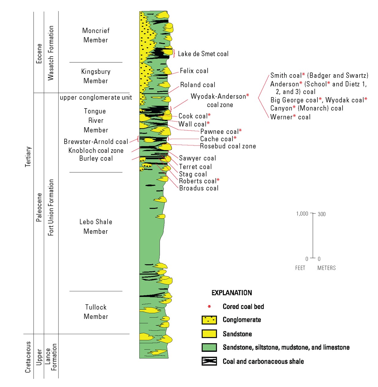
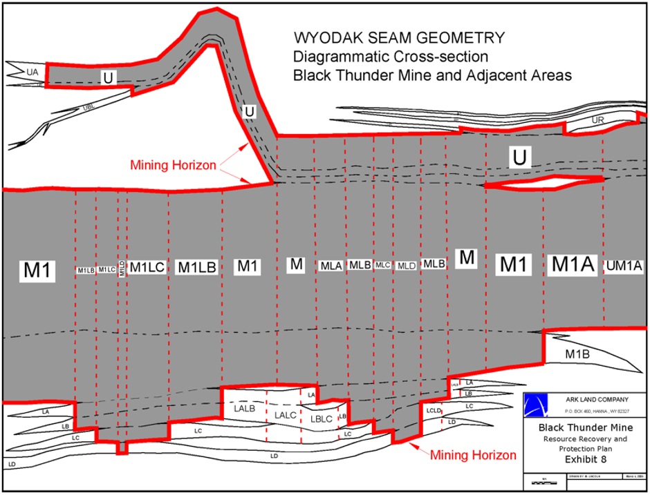
Figure 6.3-1 and Figure 6.3-2 show the stratigraphic column and the Upper and Main Wyodak splits cross section related to Black Thunder.
Figure 6.3-1 Stratigraphic Column
Source: U.S. Geological Survey Open-File Report 98-0789B-B (1998)
February 9, 2026
29
Weir Technical Report Summary
Black Thunder Mine
Prepared for Core Resources, Inc.
Figure 6.3-2 Wyodak Seam Cross Section Northwest to Southeast
Source: Ark Land Company
February 9, 2026
30
Weir Technical Report Summary
Black Thunder Mine
Prepared for Core Resources, Inc.
7.0 EXPLORATION
7.1 NON-DRILLING EXPLORATION
Drilling has served as the sole form of exploration carried out on the Black Thunder property.
7.2 DRILLING
Exploration activities exclusively involve drilling performed by competent contract drilling companies. Exploration drilling at Black Thunder has been a two-stage approach. Initial spot core drilling is conducted on a widely spaced, one-half mile, pattern in order to delineate potential lease areas. Once the area has been leased, development drilling is conducted three to five years in advance of pit development. This drilling is generally on a 500 feet north/south grid with alternating rotary and spot core holes and is done in conjunction with dewatering endeavors. This arrangement results in a seam geometry data spacing of 500 feet and a coal quality data spacing of 1,000 feet. Drilling is conducted with rotary drilling rigs capable of 1,000 feet depths.
All holes are geophysically logged with a standard coal suite tool consisting of gamma, density, caliper, and resistivity. Geophysical logging contractors provide paper copies, .TIF files, and .LAS files.
Spot core holes are rotary drilled to a core point which is projected from the geologic computer model and may be adjusted in the field as drilling progresses. A 3-inch diameter core is then extracted in roughly 20 feet core runs by tripping pipe out of the hole for each core run.
Upon reaching the surface, the split-tube core barrel is opened, core is washed down if necessary, and the driller’s reported length of core that was actually cut is compared to the measured length of core actually recovered. Total core loss for the entire seam is generally less than two feet. If a section of core greater than 10 feet, or less if in a critical zone, is lost, then the hole is re-drilled to recover the lost interval.
Coal sampling for the Upper split of the Wyodak Seam is in 1.0 foot increments for the top and bottom of the seam and evenly proportioned samples of 5 to 10 feet for the remainder of the seam. Sampling for the Main split of the Wyodak Seam is in 1.5 feet increments for the
February 9, 2026
31
Weir Technical Report Summary
Black Thunder Mine
Prepared for Core Resources, Inc.
top and bottom of the seam, and 10 feet increments for the remainder of the seam. All partings encountered, down to a thickness of 0.4 foot, are sampled separately.
A hole with significant lost core or crushed core can result in misleading data. Drillholes with core recovery of less than 90 percent are to be noted and subsequently reviewed and potentially excluded from geological and coal quality modeling. WEIR did not exclude any drillholes for poor core recovery, as all of the holes within Black Thunder mine property attained core recovery of at least 90 percent. During core drilling, all core samples are boxed, photographed, and stored. Roof and floor strata core samples are sent to laboratories for geotechnical strength tests. Coal seam core samples are sent to laboratories for quality analyses. Caliper, density, gamma, resistivity, and sonic downhole geophysical logs are completed as drill site and hole conditions allow. Each drillhole collar location is surveyed for accurate map coordinate and elevation data.
All original drillhole, survey, geological, geophysical, and quality data is scanned and stored on a Core server, which is backed up nightly, and can be accessed by select Core personnel and quickly checked against the database, the geological model, or mine mappings. The original copies are stored in an offsite warehouse.
WEIR did not have direct involvement with the planning, implementation or supervision of Core’s drilling programs. However, having reviewed the details of each drilling program, WEIR finds the planning, implementation and supervision of Core’s drilling programs, with all data derived from the drilling programs, to be consistent with industry standards, and sufficient and relevant for use in the estimation of reserves and resources. Weir did not exclude any drill holes from the model.
7.3 HYDROGEOLOGY
Black Thunder is situated in the southern portion of the PRB, within the Cheyenne River watershed and Upper Powder and Antelope sub-basins. The Black Thunder permit area is located on the east limb of the Powder River Structural Basin in northeastern Wyoming. The east limb of the basin dips two to three degrees to the west. The primary drainage in the Black Thunder permit area is Little Thunder Creek, fed by several tributaries within the permit boundary.
Principal aquifers within the Black Thunder area include the Fort Union and overlying Wasatch Formations. These Tertiary Age sand and mudstones occur in the upper portion of the Wasatch-Fox Hills hydrographic sequence (see Figure 6.3-2). The Wasatch-Fox Hills
February 9, 2026
32
Weir Technical Report Summary
Black Thunder Mine
Prepared for Core Resources, Inc.
sequence is 1,350 feet in thickness in the northern part of the PRB and thickens to approximately 7,000 feet in Converse County, Wyoming. On a regional basis, flow moves from peripheral recharge areas (along scoria outcrops) toward the center of the basin, primarily controlled by stratigraphy and surface water streamflow. Within the Black Thunder permit area, the gradient dips gently to the west, with head elevations ranging from 4,590 to 4,680 feet.
Core has engaged in extensive modeling to characterize site hydrogeology and to determine groundwater inventories, water quality, and potential impacts to local usage as part of its NPDES permitting process with the Wyoming DEQ. Baseline flow and quality parameters for surface and groundwater inventory have been established and monitored as required by the Wyoming DEQ. Black Thunder maintains an extensive groundwater monitoring network which is approved by Wyoming DEQ-LQD and currently comprised of approximately thirty wells representing well competitions in overburden, underburden, scoria, coal, backfill, and alluvium. These wells are evaluated for both quality and quantity on either a semi-annual or annual basis. Results are reported annually to Wyoming DEQ-LQD. Groundwater impact has been evaluated through seven ground water modeling investigations conducted for the coal aquifer at the Black Thunder Mine.
Water sampling methods for Black Thunder are outlined and maintained by Core in a site-specific work practice document. Reviewed annually, this operating procedure document details sampling locations, frequency, and collection protocols, including storage, transport, delivery and required chain of custody documentation. Approved methods for field data collection and instrument calibration are described, along with methods for creating sample splits, duplicates, and blind standards.
Samples are analyzed by independent laboratories that follow the most recent approved Environmental Protection Agency (EPA) sampling methodology and procedures. The laboratories employ internal quality control and quality assurance protocols before reporting results to Core. Core personnel then review the results again, as a second check for quality control and assurance, before the results are published.
Groundwater inventories, water quality data, water balance, recharge and seepage rates have been reviewed in the approved permit and current permit revisions, including hydrologic impact assessments outlining risks, monitoring program detail, and mitigation obligations. Core’s approach to obtaining and managing its surface and groundwater data for Black Thunder has been demonstrated to be adequate and aligned with regulatory requirements and
February 9, 2026
33
Weir Technical Report Summary
Black Thunder Mine
Prepared for Core Resources, Inc.
standard industry practices. Black Thunder monitors surface water at three locations with two of the three sites representing up-stream native conditions and one location capturing downstream effects. All streams in and around Black Thunder are ephemeral and monitored only in response to flow when it occurs. During the months of April to November, in-stream bubbler/pressure transducer data loggers are deployed to collect water quantity data. Quality is typically monitored on a semi-annual basis and intended to capture both spring thaw runoff and thunderstorm/rain events when possible. Sampling is conducted as approved by WY DEQ-LQD. Results are reported annually to WY DEQ-LQD. Should a discharge of water be initiated, samples are collected accordance with WYPDES permits. WEIR finds no material barriers to the continued success of Black Thunder regarding hydrologic impact or compliance.
7.4 GEOTECHNICAL DATA
A geotechnical study of highwall stability for the North, West, and South Pits at Black Thunder was completed by Barr Engineering (Minneapolis, Minnesota) in 2021 as part of a review of the mine’s ground control plan (GCP). Previous geotechnical study and GCP review at Black Thunder were completed in 1973, 2002, 2004, and 2009. Coring, logging, and geophysical logging of 10 boreholes were performed to characterize the lithology of the site and obtain drill core samples of the overlying sand and mudstones. Resulting samples were transported to Soil Engineering Testing (SET), located in Richfield, Minnesota, for geotechnical analysis. Analysis performed include index and soil properties, permeability, and shear strength under the appropriate American Society for Testing and Materials (ASTM) specifications. The current study results indicated that Black Thunder’s current open pit design geometries, as documented in the current ground control plan, are satisfactory to provide safe and stable slopes for the foreseeable 5-year mine plan based on available information. Modeling of the subsurface geological conditions with the final pit wall geometry indicate an expected Factor of Safety (FOS) greater than 1.2. Even for further reduced uniform strength cases, the FOS is greater than 1.0, further suggesting overall pit wall failure is unlikely based on known conditions.
Each cored drillhole included a companion, offset hole that was logged with downhole geophysics (e-logged) by Goodwell, Inc. located in Gillette, Wyoming, and reviewed by Pronghorn Geologic Services located in Gillette, Wyoming. Lithology for each hole was determined using gamma and density downhole data. Slope stability and seepage modeling for both drained and undrained mining conditions were completed to assess the stability of the highwall cuts in each pit.
February 9, 2026
34
Weir Technical Report Summary
Black Thunder Mine
Prepared for Core Resources, Inc.
7.5 SITE MAP AND DRILLHOLE LOCATIONS
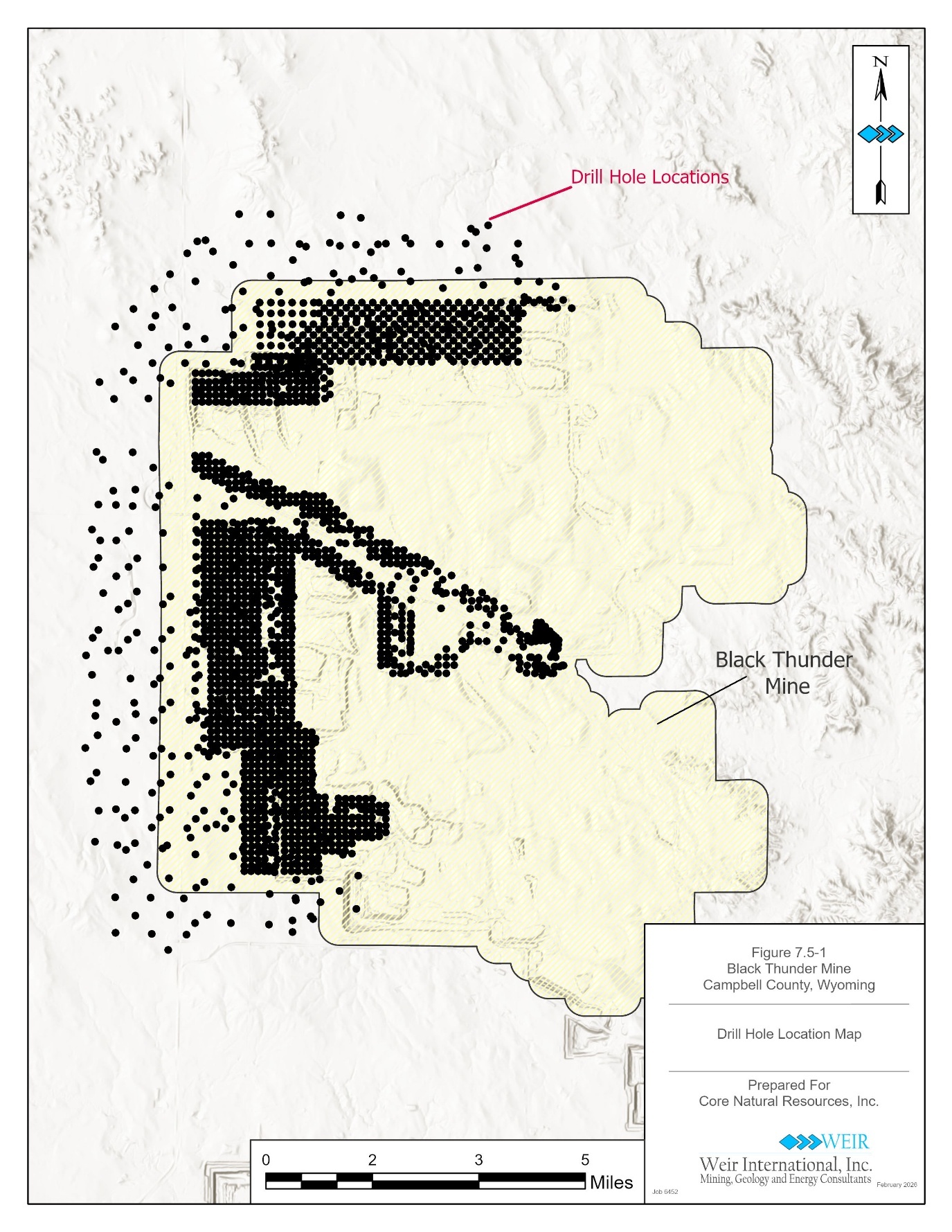
A map showing the location of all drillholes used to estimate tonnage on the Black Thunder property is shown on Figure 7.5-1.
February 9, 2026
35
Weir Technical Report Summary
Black Thunder Mine
Prepared for Core Resources, Inc.
Figure 7.5-1 Drillhole Collar Locations
7.6 DRILLING DATA
February 9, 2026
36
Weir Technical Report Summary
Black Thunder Mine
Prepared for Core Resources, Inc.
Core generally uses Matheson Drilling, Inc. located in Gillette Wyoming to drill core holes. Downhole geophysical logging is performed by Goodwell Inc., located in Upton, Wyoming. Coal quality analyses are currently performed by Standard Laboratories, Inc. (Standard) located in Casper, Wyoming.
February 9, 2026
37
Weir Technical Report Summary
Black Thunder Mine
Prepared for Core Resources, Inc.
8.0 SAMPLE PREPARATION, ANALYSES, AND SECURITY
8.1 SAMPLE PREPARATION METHODS AND QUALITY CONTROL
Once the target coal seam has been drilled and immediately after logging of the core, all coal samples obtained are placed in labeled plastic core sleeves, sealed, and placed in labeled core boxes. The geologist’s seam thickness measurements are checked against the geophysical logs for thickness accuracy and to confirm core recovery. The samples are coded and labeled with sample identification numbers based on drillhole id (for example, DT2001), sample sequence (A, B, C, etc.), and sample number, (1, 2, 3 etc.), (for example, DT2001A1 = first sample of first seam in drillhole DT2001.) These boxes are kept by the geologic contractor in their storage area until a sufficient load is collected and then delivered directly to the coal analysis lab by the geologic contractor.
Samples are not split or reduced prior to delivery. The full length and diameter of the 3 inch core samples are delivered to the coal analysis laboratory.
8.2 LABORATORY SAMPLE PREPARATION, ASSAYING, AND ANALYTICAL PROCEDURES
8.2.1 Laboratory
Coal analysis for all exploration drilling is conducted by an independent third-party contractor, Standard Laboratories, Inc. (Standard Laboratories) located in Casper, Wyoming. Standard Laboratories conducts all testing under applicable ASTM standards and is accredited by the ANSI National Accreditation Board. Sample preparation by Standard Laboratories includes crushing to suitable size and then creating an appropriate number of splits to accommodate retain samples and composite analyses samples.
All incremental samples receive an as-received short proximate analysis consisting of percent moisture, percent ash, percent sulfur, and Btu/lb. After receiving the results of the short proximate analysis, composite analysis increments are selected based on mining units and sent to Standard Laboratories. For most holes, these composite analyses include Full Proximate, Ash Fusion, Mineral Analysis of Ash, Equilibrium Moisture, Trace Element PPM - Mercury, and Trace Element PPM - Chlorine.
February 9, 2026
38
Weir Technical Report Summary
Black Thunder Mine
Prepared for Core Resources, Inc.
For approximately 10 percent of the holes, the composite analyses includes Full Proximate, Ultimate Analysis, Forms of Sulfur, 8-point Ash Fusion, Mineral Analysis of Ash, Water Soluble Alkalis, Hardgrove Grindability Index, Equilibrium Moisture, and Full Trace Element PPM - 27 elements.
Standard Laboratories is certified by ANSI National Accreditation Board and located at 1880 N Loop Ave, Casper, Wyoming 82601
8.3 QUALITY CONTROL PROCEDURES AND QUALITY ASSURANCE
Quality control procedures followed by Core geologists are clearly defined. Core field geologists take defined and specific steps to protect sample integrity and to ensure core samples are always under the control of the Core field geologist. These steps include the following:
•Field geologist to be on site whenever drilling is occurring
•Geologist’s log to be created for each drillhole
•Each drillhole to be logged using geophysical methods
•Geologist to compare field geologist’s logs to the e-log data
•Geologist to compare the core samples against both field geologist’s logs and e-logs to confirm coal thickness
•All core to be boxed and photographed
•Quality sample sheets to be filled out, provided to a supervisor for approval and shipped to the laboratory
•Once core samples have been analyzed, field geologists scrutinize the resulting quality data for accuracy
•Based on the homogeneity of the deposit and the consistent quality of the reserve area as evidenced from the product produced from this active mine, analytical laboratories are instructed to divide the samples and retain the second split for additional analysis should the original test report any anomalies.
8.4 SAMPLE PREPARATION, SECURITY, AND ANALYTICAL PROCEDURES ADEQUACY
February 9, 2026
39
Weir Technical Report Summary
Black Thunder Mine
Prepared for Core Resources, Inc.
Core’s procedures for quality analyses provide a full range of coal quality so that engineers and sales staff, reviewing and evaluating the data, have a complete listing of coal seam quality for each drillhole completed by Core.
Drillhole core samples are assigned a sample ID number, and a sample label is created. The label includes drillhole ID, sample ID number, and the to and from depths of the sample. The sample is then placed in a bag with the label. The bags are sealed using zip ties or tape, which begins the chain of custody. The samples do not leave possession of the geologist once removed from the core barrel. The samples remain with the geologist or are stored in a locked facility that only Core geologists can access until delivery of the samples to the contracted laboratory. The delivery of the samples is carried out within one week of drillhole completion. Once in possession of the certified laboratory, the laboratory’s security procedures are followed, all in accordance with standard industry sampling preparation and analyses. After the sample has been tested, reviewed, and accepted, the disposal of the sample is in accordance with local, state, and EPA approved procedures.
Once satisfied that the data laboratory testing reports are accurate, the quality analyses are entered into the Core coal database. Upon data entry completion, the modeling geologists export the data and inspect the data for variance from expected norms. If any data is outside the norm for the property, the data is checked against laboratory results to ensure proper data entry. Once proper data entry is confirmed, quality data is gridded and mapped, with any anomalies in the data mapping investigated. If anomalies are determined to be present, the anomalies are brought to the attention of the geologists, mine engineers and sales staff.
WEIR has determined the sample preparation, security and analysis procedures for the Black Thunder drillhole samples are in accordance with current industry standards for quality testing, with laboratory results suitable to use for mineral resource estimation and related geological modeling.
February 9, 2026
40
Weir Technical Report Summary
Black Thunder Mine
Prepared for Core Resources, Inc.
9.0 DATA VERIFICATION
9.1 DATA VERIFICATION PROCEDURES
WEIR reviewed and evaluated copies of all Core drilling records for the Black Thunder LOM Plan area, which included Excel spreadsheets, driller’s log, field geologist’s logs, quality results sheets from the coal quality laboratories, mine measurement tables, as well as drawing files or PDFs of the e-logs. Each drillhole within the LOM Plan was individually checked by WEIR against a copy of the driller’s and/or geologist’s log to confirm data accuracy.
Geological reviews performed by WEIR included:
•Drillhole lithology database comparison to geophysical logs
•Drillhole coal quality database comparison to quality certificates
After WEIR completed the precursory verifications and validations described above, the drillhole data was loaded into Datamine’s MineScape® Stratmodel, a geological modeling package. MineScape provides robust error checking features during the initial data load, which include confirmations of seam continuity, total depth versus hole header file data, interval overlap, and quality sample continuity with coal seams. Once the drillhole data was loaded, a stratigraphic model was created.
Several further verifications were then possible, which include:
•Creating cross sections through the model to visually inspect if anomalies occur due to miscorrelation of seams
•Creating structural and quality contour plots to visually check for other anomalies due to faulty seam elevations or quality data entry mistakes in the drillhole database
Typical errors which may impact reserve and resource estimation relate to discrepancies in original data entry, and might include:
•Unnoticed erroneous quality analyses where duplicate analyses were not requested
February 9, 2026
41
Weir Technical Report Summary
Black Thunder Mine
Prepared for Core Resources, Inc.
•Unrecorded drillhole core loss
WEIR conducted a detailed, independent geological evaluation of the data provided by Core, designed to identify and correct errors of the nature listed above. Where errors were identified and could not be successfully resolved, it is WEIR’s policy to exclude that data from the geological model. Based on its geological evaluation of data provided, WEIR did not exclude any holes within the Black Thunder LOM Plan area.
9.2 DATA VERIFICATION LIMITATIONS
WEIR did not conduct an independent verification of property control surveys, nor has it independently surveyed the mining locations. Rather, WEIR relied on information compiled from maps and summaries of the owned and leased property control prepared by Core. WEIR did not conduct a legal title investigation relative to Core’s mineral and surface rights, although there was no reason to believe, based on review of the Black Thunder permit, that Core does not control (by ownership or lease) the coal or surface lands necessary to implement the Black Thunder LOM Plan.
9.3 ADEQUACY OF DATA
It is WEIR’s opinion that the adequacy of sample preparation, security, and analytical procedures for the holes that were drilled by Core, after acquiring the property, are acceptable and meet typical industry standards. Core employs detailed processes and procedures, described in Section 8.4 of this TRS, that are followed each time a core hole is to be sampled. The Core geologist’s logs for these holes contain sampling descriptions and lithologic descriptions that are sufficiently detailed to ascertain that an experienced geologist supervised the drilling and sampling. Core coal quality analyses were performed to ASTM standards by qualified laboratories, as detailed in Section 8.0 of this TRS.
The adequacy of sample preparation, security, and analytical procedures are generally unknown for drillholes that were drilled prior to Core’s predecessor company acquiring the property in 1998. It is unknown if coal quality analyses were performed to ASTM standards by qualified laboratories, as detailed in Section 8.0 of this TRS. This legacy drillhole information was included because these holes, drilled prior to 1998, are within the surface mine workings and have already been mined through and have no influence within the Black Thunder LOM Plan going forward. Model verifications further support WEIR’s high level of confidence that a representative, valid, and accurate drillhole database and geological model
February 9, 2026
42
Weir Technical Report Summary
Black Thunder Mine
Prepared for Core Resources, Inc.
have been generated for Black Thunder that can be relied upon to accurately estimate mineral resources and reserves.
February 9, 2026
43
Weir Technical Report Summary
Black Thunder Mine
Prepared for Core Resources, Inc.
10.0 MINERAL PROCESSING AND METALLURGICAL TESTING
10.1 MINERAL PROCESSING TESTING AND ANALYTICAL PROCEDURES
Mineral processing testing and analytical procedures are not applicable since no mineral processing or metallurgical testing is required at Black Thunder.
After the coal is drilled and blasted, the coal is loaded by large loading shovels or front-end loaders into haul trucks for transport to crushing facilities where the coal is reduced to a final product size of two to three inches. The sized coal product is then conveyed to either the slot coal storage or the silos. As the coal travels along the belt conveyor, a sample cutter drops down intermittently, cuts a sample through the coal, and crushes it into a powder. The onsite laboratory then analyzes the samples to determine the coal quality.
10.2 MINERALIZATION SAMPLE REPRESENTATION
Coal deposits originate in flat, low-lying ground within deltas, alluvial plains, and coastal systems, and as such are a relatively homogeneous, sedimentary mineral occurrence. The deposit within Black Thunder exhibits homogeneous characteristics and does not show any substantial variations in mineralization types or styles that would adversely affect the saleable coal product. Sample data are well representative of the deposit as a whole.
10.3 ANALYTICAL LABORATORIES
The saleable coal product that is sampled from the belt conveyor is tested at Core’s onsite laboratory to determine that the coal is meeting customer quality specifications. Core’s onsite laboratory is not certified. The laboratory performs ASTM and ISO methods for quality analysis to aid in projecting compliance to customers. Customers can request additional testing at an offsite laboratory for further analysis.
10.4 RELEVANT RESULTS AND PROCESSING FACTORS
The coal is sold as a ROM product and is not processed, except for being crushed to a two to three inch top size, depending on customer requirements. As such, processing factors including deleterious elements are not expected to significantly impact the economics of extraction.
February 9, 2026
44
Weir Technical Report Summary
Black Thunder Mine
Prepared for Core Resources, Inc.
10.5 DATA ADEQUACY
Core employs testing and analytical procedures in accordance with industry standards, which result in efficient material handling operations that provide requisite quality control to meet product quality projections. The testing performed is sufficient to support the projected saleable product quality for the Black Thunder LOM Plan.
February 9, 2026
45
Weir Technical Report Summary
Black Thunder Mine
Prepared for Core Resources, Inc.
11.0 MINERAL RESOURCE ESTIMATES
The mineral resources, as of December 31, 2025, are reported as in-place resources and are exclusive of reported coal reserve tons (see Section 12.0 for reserve tonnage estimates). Resources are reported in categories of Measured, Indicated and Inferred tonnage, in accordance with Regulation S-K Item 1302(d)(1(iii)(A)).
11.1 KEY ASSUMPTIONS, PARAMETERS, AND METHODS
Data Sources
Planimetric data was provided by Core in AutoCAD format and primarily included base map information such as rivers, drainages, roads, mine features, and property boundaries.
The Core drillhole data reviewed by WEIR included lithology, coal quality, and survey data, and was provided in different formats including Excel, ASCII files and PDFs. Geophysical logs, coal quality certificates, driller’s logs, geologist’s logs, downhole deviation data, and drillhole survey records were provided as scanned PDF files and AutoCAD drawing files. Data was provided for 2,042 drillholes, all of which are included in the structural model.
Coal quality data for 1,340 drillholes was provided for Black Thunder, with all 1,340 holes used in the quality model. Data was provided in Excel format along with quality certificates in PDF. Reasons for excluding drillhole quality samples in the modeling process included:
•Poor core recovery noted in the driller’s logs.
•Quality logs that could not be matched to a drillhole.
•The quality listed for the drillhole was not relevant to the model (for example raw Btu/lb. or sulfur were supplied, but not final product Btu/lb. or sulfur). The only relevant raw values used were specific gravity and raw ash. Both are derivable from one another and have bearing on estimated in-place tons.
Geological Model
The Black Thunder geological model was constructed by using seam surface grids that were created in Datamine’s MineScape® Stratmodel (MineScape) geological modeling package.
Topography data was gridded using MineScape software and a grid cell size of 50 feet by 50 feet. Topographic contours from the USGS were provided by Core in CAD format in 25-foot
February 9, 2026
46
Weir Technical Report Summary
Black Thunder Mine
Prepared for Core Resources, Inc.
intervals. The contours were provided in the NAD83, Wyoming East State Plane coordinate system (FIPS 4901). The gridded USGS topography contours were compared to drillhole collars and showed that there are differences between the two sets of elevation data. On average, the drillhole collars are less than five feet above or below the USGS topography grid, with the maximum difference of 47 feet. The holes, with the greatest difference, are all outside of the Black Thunder LOM Plan. The hole with the greatest difference within the LOM is approximately 17 feet. These differences are not uncommon when comparing a national data set to localized collar elevations. For this reason, WEIR has not excluded any of the drillholes that have a large elevation difference.
The seam surfaces and thicknesses were created by loading the drilling and mine measurement data into MineScape and gridding the seam intercepts using a grid cell size of 50 feet by 50 feet. The parameters used to create the model are defined in the MineScape modeling schema, which is a specification of modeling rules created for the site. The MineScape interpolators that were used in this study are common in most mine planning software packages. The Planar interpolator is a triangulation method with extrapolation enabled. Finite Element Analysis (FEM) is a widely used method for numerically solving differential equations arising in engineering and mathematical modeling. A trend surface is used in MineScape to promote conformability for the modeled seams to regional structures such as synclines, anticlines, or simply seam dip. MineScape caters to using different interpolators for thickness, roofs and floors (surfaces), and the selected trend surface as they are all modeled separately. The interpolator used for each of these items is selected on the basis of appropriateness to the data sets involved, as well as modeling experience. Stratigraphic Model Interpolators are shown in Table 11.1-1 as follows:
Table 11.1-1 Stratigraphic Model Interpolators
Interpolator
Parameter
Power/Order
Planar
Thickness
0
FEM
Surface
1
Planar
Trend
0
The coal seams that were modeled for this TRS are the Upper and Main splits of the Wyodak Seam. A summary of statistics for these drillholes are shown in Table 11.1-2.
February 9, 2026
47
Weir Technical Report Summary
Black Thunder Mine
Prepared for Core Resources, Inc.
Table 11.1-2 Drillhole Statistics
Average
Minimum
Maximum
Number of
Thickness
Hole
Thickness
Hole
Thickness
Seam
Intercepts
(Feet)
Name
(Feet)
Name
(Feet)
WYODAK - Upper
1880
12.79
ARCHFED43-34
3.5
BT3794
20.8
WYODAK - Main
1880
73.77
070C2840
37.5
BT3744
73.2
The gridded structure surfaces and coal seam thicknesses were validated against drillhole information to ensure that the data was properly modeled. Inconsistencies between modeled seam surfaces and surrounding drillholes were investigated and any confirmed errors in the drillhole data or model parameters were corrected. This process was repeated until a final version of the model was developed.
Coal Quality Model
The drillhole quality data described previously in this report were used to create a raw coal quality model that included raw ash, raw Btu/lb, raw total sulfur, equilibrium moisture, volatile matter, fixed carbon and raw relative coal density.
The drillholes were verified to ensure that the seam depths used in the lithology file matched the sample depths in the quality file, with 1,340 drillholes found to have a fully sampled interval that included the Wyodak Upper split and/or the Wyodak Main split. In each of these 1,340 drillholes, the samples were composited and added to the quality model.
Coal quality samples were loaded into MineScape and composited against the drillhole thicknesses. The composited values were then gridded using a grid cell size of 200 feet by 200 feet and the inverse distance weighted (squared) interpolator. The following quality data was modeled for the Upper and Main splits of the Wyodak Seam:
•Raw
Ash, Dry, weight percent
Calorific Value, Dry, Btu/lb
Total Sulfur, Dry, weight percent
Equilibrium Moisture, weight percent
Volatile Matter, Dry, weight percent
Fixed Carbon, Dry, weight percent
Hargrove Grindability Index, Dry
Relative Density
February 9, 2026
48
Weir Technical Report Summary
Black Thunder Mine
Prepared for Core Resources, Inc.
Quality contours were generated from the grids to check outlier values.
Additional Resource Criteria and Parameters
Based on WEIR’s review and evaluation of the data and plans relative to the Black Thunder LOM Plan, resource estimation criteria were applied to ensure reported mineral resource tonnage has a reasonable prospect for economic extraction. Resource criteria and parameters for Black Thunder are as follows:
•Resources were estimated as of December 31, 2025.
•Coal density was based on a default apparent relative density (ARD) of 1.28 grams/cubic centimeter.
•Areas where coal thickness did not meet a minimum thickness of 5.0 feet were excluded from the resource estimate.
•Tons with less than 30 feet of cover were considered to be weathered and were excluded from resource estimates.
•A maximum cut-off parting thickness of 0.75 foot for mining the lower seam splits.
•Areas not considered feasibly accessible because of geometry and location in relation to previous mine workings were excluded from resource estimates.
•Tonnage outside of current Black Thunder LOM Plan, but within existing property control, and meeting the criteria listed here, was classified as Resource tonnage and is reported exclusive of Reserve tonnage.
•Core does not use a maximum Stripping Ratio cut-off.
Quality contours were generated from the grids to check outlier values. Maps showing average Raw quality on an as received basis are shown below on Figures 11-1.1 through 11.1-6.
February 9, 2026
49
Weir Technical Report Summary
Black Thunder Mine
Prepared for Core Resources, Inc.
Figure 11.1-1 Wyodak - Upper Seam Raw Ash, as Received
February 9, 2026
50
Weir Technical Report Summary
Black Thunder Mine
Prepared for Core Resources, Inc.
Figure 11.1-2 Wyodak - Upper Seam Raw BTU, as Received
February 9, 2026
51
Weir Technical Report Summary
Black Thunder Mine
Prepared for Core Resources, Inc.
Figure 11.1-3 Wyodak - Upper Seam Raw Sulfur, as Received
February 9, 2026
52
Weir Technical Report Summary
Black Thunder Mine
Prepared for Core Resources, Inc.
Figure 11.1-4 Wyodak - Main Seam Raw Ash, as Received
February 9, 2026
53
Weir Technical Report Summary
Black Thunder Mine
Prepared for Core Resources, Inc.
Figure 11.1-5 Wyodak - Main Seam Raw BTU, as Received
February 9, 2026
54
Weir Technical Report Summary
Black Thunder Mine
Prepared for Core Resources, Inc.
Figure 11.1-6 Wyodak - Main Seam Raw Sulfur, as Received
February 9, 2026
55
Weir Technical Report Summary
Black Thunder Mine
Prepared for Core Resources, Inc.
11.2 ESTIMATES OF MINERAL RESOURCES
The mineral resources, as of December 31, 2025, are reported as in-place resources and are exclusive of reported coal reserve tons (see Section 12.0). Resources are reported based on the coal resource estimate methodology described and are summarized in Table 11.2-1 as follows:
Table 11.2-1 In-Place Coal Resource Tonnage and Quality Estimate, as of December 31, 2025
Raw Coal Quality (As Received)
Average Coal
Average
Calorific
Area
Thickness
In-Place Resources (000 Tons)
Stripping Ratio
Ash
Sulfur
Volatile
Value
Seam
(Acres)
(Feet)
Measured
Indicated
Total
(BCY/T)
(%)
(%)
Matter
(Btu/lb)
WYODAK - Upper
1,200
13.49
25,000
—
25,000
—
5.1
0.55
33.1
8,950
WYODAK - Main
1,375
73.12
175,000
5,000
180,000
—
4.0
0.23
31.9
8,990
200,000
5,000
205,000
4:1
4.1
0.27
32.0
8,980
Notes:
•Mineral Resources reported above are not Mineral Reserves and do not meet the threshold for reserve modifying factors, such as estimated economic viability, that would allow for conversion to mineral reserves. There is no certainty that any part of the Mineral Resources estimated will be converted into Mineral Reserves. Mineral Resources reported here are exclusive of Mineral Reserves.
•Resources stated as contained within a potentially economically mineable surface mine assuming a thermal coal product realizing a sales price of $15.77 per ton FOB Mine and operating cost of $14.57 per ton
•Numbers in the table have been rounded to reflect the accuracy of the estimate and may not sum due to rounding.
11.3 TECHNICAL AND ECONOMIC FACTORS FOR DETERMINING PROSPECTS OF ECONOMIC EXTRACTION
A PFS was conducted to assess the prospects for economic extraction of coal within Black Thunder.
The FOB Mine coal sales price used in assessing the economic mineability of the Black Thunder is primarily based on sales of a thermal coal product, which had an average coal sales price of $14.83 per ton in 2024 through September 2025 and is projected to average $15.77 per ton over the Black Thunder LOM Plan. The sales price is further supported in Section 16.0 of this TRS.
Capital expenditures (including contingency) are discussed in further detail in Section 18.1 of this TRS and are projected to average $0.37 per ton over the Black Thunder LOM Plan, which are higher than actual capital expenditures for Black Thunder of $0.23 per ton in 2024 through September 2025.
February 9, 2026
56
Weir Technical Report Summary
Black Thunder Mine
Prepared for Core Resources, Inc.
Operating costs are discussed in further detail in Section 18.2 of this TRS and are projected to average $14.57 per ton over the Black Thunder LOM Plan, compared to actual Black Thunder operating cost of $14.04 per ton in 2024 through September 2025.
Total projected capital expenditures and operating cost of $14.94 per ton, and the coal sales price of $15.77 per ton, provide a reasonable basis for WEIR to determine that all remaining coal has prospects of economic extraction within the Black Thunder mine property.
11.4 MINERAL RESOURCE CLASSIFICATION
Mineral Resource estimates prepared for Black Thunder are based on the SEC Regulation S-K Item 1302(d)(1(iii)(A)), which established definitions and guidance for mineral resources, mineral reserves, and mining studies used in the United States. The definition standards relative to resources are as follows:
Mineral Resource:
Mineral resource is a concentration or occurrence of material of economic interest in or on the Earth's crust in such form, grade or quality, and quantity that there are reasonable prospects for economic extraction. A mineral resource is a reasonable estimate of mineralization, taking into account relevant factors such as cut-off grade, likely mining dimensions, location or continuity, that, with the assumed and justifiable technical and economic conditions, is likely to, in whole or in part, become economically extractable. It is not merely an inventory of all mineralization drilled or sampled.
•Inferred mineral resource is that part of a mineral resource for which quantity and grade or quality are estimated on the basis of limited geological evidence and sampling. The level of geological uncertainty associated with an inferred mineral resource is too high to apply relevant technical and economic factors likely to influence the prospects of economic extraction in a manner useful for evaluation of economic viability. Because an inferred mineral resource has the lowest level of geological confidence of all mineral resources, which prevents the application of the modifying factors in a manner useful for evaluation of economic viability, an inferred mineral resource may not be considered when assessing the economic viability of a mining project, and may not be converted to a mineral reserve.
•Indicated mineral resource is that part of a mineral resource for which quantity and grade or quality are estimated on the basis of adequate geological evidence and sampling. The level of geological certainty associated with an indicated mineral
February 9, 2026
57
Weir Technical Report Summary
Black Thunder Mine
Prepared for Core Resources, Inc.
resource is sufficient to allow a qualified person to apply modifying factors in sufficient detail to support mine planning and evaluation of the economic viability of the deposit. Because an indicated mineral resource has a lower level of confidence than the level of confidence of a measured mineral resource, an indicated mineral resource may only be converted to a probable mineral reserve.
•Measured mineral resource is that part of a mineral resource for which quantity and grade or quality are estimated on the basis of conclusive geological evidence and sampling. The level of geological certainty associated with a measured mineral resource is sufficient to allow a Qualified Person to apply modifying factors, as defined in this section, in sufficient detail to support detailed mine planning and final evaluation of the economic viability of the deposit. Because a measured mineral resource has a higher level of confidence than the level of confidence of either an indicated mineral resource or an inferred mineral resource, a measured mineral resource may be converted to a proven mineral reserve or to a probable mineral reserve.
Geostatistical methods were applied to drillhole and mine measurement coal thickness data for the Wyodak Seam at Black Thunder to develop variogram ranges (radii) used for resource classification. Figure 11.4-1 illustrates the variogram using 1,902 seam thickness measurements, both within and outside of the Black Thunder LOM Plan. Table 11.4-1 shows the sample count, Measured and Indicated resource ranges determined by the variogram model, and average sample spacing in feet. The theoretical ranges estimated for Measured (to 4,800 feet) and Indicated (to 14,500 feet) resources in WEIR’s variographic analysis demonstrates the spatial continuity of mineable coal seam thickness in the Wyodak Seam at Black Thunder.
Table 11.4-1 Theoretical Variogram Ranges
Average
Minimum
Maximum
Measured
Indicated
Inferred
Sample
Sample
Sample
Sample
Range
Range
Range
Spacing
Spacing
Spacing
Variogram
Count
(Feet)
(Feet)
(Feet)
(Feet)
(Feet)
(Feet)
Black Thunder Wyodak Seam
1,902
4,800
14,500
>14,500
485
28
2,327
As depicted above, variability in drillhole thickness measurements is highly correlated with the distance between individual drillholes, in particular within the theoretical ranges for Measured and Indicated tonnage. Additionally, WEIR’s generation and review of the
February 9, 2026
58
Weir Technical Report Summary
Black Thunder Mine
Prepared for Core Resources, Inc.
applicable quality contours further supports the continuity of coal quality throughout the deposit.
The theoretical ranges estimated for Measured (to 4,800 feet) and Indicated (to 14,500 feet) resources in WEIR’s variographic and quality analysis demonstrates the spatial continuity of mineable coal seam thickness and quality in the Wyodak Seam at Black Thunder. WEIR has a high level of geological confidence in this data and considers it sufficient to allow for the application of modifying factors to support detailed mine planning and evaluation of the economic viability of the deposit within the Measured and Indicated ranges.
WEIR has chosen to apply classification radii more conservative than the theoretical radii demonstrated above to be consistent with previous reporting for the Black Thunder deposit. Greater than 99 percent of the estimated tons are classified as measured using the more conservative radii distances. Selection of more conservative classification radii only further increases confidence within the various tonnage classification categories.
Classification radii utilized by WEIR in this study are as follows:
•Measured: 0 - 1,320 feet (based on 1,902 observations informing estimate of coal thickness within this range)
•Indicated: 1,320 - 3,960 feet (based on 1,902 observations informing estimate of coal thickness within this range)
•Inferred: greater than 3,960 feet (based on 1,902 observations informing estimate of coal thickness within this range)
11.5 UNCERTAINTY IN ESTIMATES OF MINERAL RESOURCES
Mining is a high risk, capital-intensive venture and each mineral deposit is unique in its geographic, social, economic, political, environmental, and geologic aspects. At the base of any mining project is the mineral resource itself. Potential risk factors and uncertainties in the geologic data serving as the basis for deposit volume and quality estimations are significant considerations when assessing the potential success of a mining project.
Geological confidence may be considered in the framework of both the natural variability of the mineral occurrence and the uncertainty in the estimation process and data behind it. The mode of mineralization, mineral assemblage, geologic structure, and homogeneity naturally vary for each deposit. Structured variability like cyclic depositional patterns in sedimentary rock can be delineated mathematically with solutions like trend surface analysis or
February 9, 2026
59
Weir Technical Report Summary
Black Thunder Mine
Prepared for Core Resources, Inc.
variography. Unstructured variability, in the distribution of igneous rock composition, for example, is more random and less predictable.
The reliability of mineral resource estimation is related to uncertainties introduced at different phases of exploration. Resources meeting criteria for Measured, Indicated, and Inferred categories are determined by the quality of modeled input data, both raw and interpreted. An exploration program comprises several stages of progressive data collection, analysis, and estimation, including:
⦁ Geological data collection
⦁ Geotechnical data collection
⦁ Sampling and assaying procedures
⦁ Bulk density determination
⦁ Geological interpretation and modeling
⦁ Volume and quality estimation
⦁ Validation
⦁ Resource classification and estimation
Error may be introduced at any phase. Data acquisition and methodologies should be properly documented and subject to regular quality control and assurance protocols at all stages, from field acquisition through resource estimation. Managing uncertainty requires frequent review of process standards, conformance, correctional action, and continuous improvement planning. Risk can be minimized with consistent exploration practices that provide transparent, backwards traceable results that ultimately deliver admissible resource estimates for tonnage and quality.
Less dense drillhole coverage in the southwestern portion of Black Thunder is a source of uncertainty, however, that uncertainty is reflected in the classification of Indicated resources versus Measured resources.
As discussed in Sections 8.0, 9.0, and 10.0 of this TRS, it is WEIR’s opinion that Core’s methodologies of data acquisition, record-keeping, and QA/QC protocols are in accordance with Core procedures, and are adequate and reasonable for resource estimation at Black Thunder.
In summary, WEIR has reviewed all geologic and geotechnical data inputs, collection protocols, sampling, assaying, and laboratory procedures serving as the basis for the deposit model, its interpretation, and the estimation and validation of the quantity and quality of mineral resources at Black Thunder. The spatial continuity of the Upper and Main splits of
February 9, 2026
60
Weir Technical Report Summary
Black Thunder Mine
Prepared for Core Resources, Inc.
the Wyodak Seam coal deposit at Black Thunder is well demonstrated by professionally developed, well maintained, quantitative and qualitative data. WEIR finds no material reason regarding geologic uncertainty that prohibits acceptably accurate estimation of mineral resources.
11.6 ADDITIONAL COMMODITIES OR MINERAL EQUIVALENT
There are no other commodities or minerals of interest within the Black Thunder resource area other than the coal deposit discussed in this TRS.
11.7 RISK AND MODIFYING FACTORS
The concentration of drilling within the exclusive resource area is less dense than the rest of the Black Thunder property. The resource area is a long thin area, approximately 37,000 feet by 1,000 feet, that bounds the Black Thunder LOM Plan to the west. Drilling within the adjacent LOM Plan reserve area make up the bulk of the data points used for resource estimation. Many of these drillholes are within 200 to 800 feet of the boundary between the reserve and resource areas. However, the spacing increases to the west. The average drillhole spacing ranges from 800 to 1,300 feet (one instance of approximately 3,000 feet). This wider spacing can decrease the confidence of structural features, including seam thickness, and top and bottom elevations. The resource area at Black Thunder is bounded by the LOM Plan in the east and by Core’s lease control boundary in the west. Additional drilling in the Black Thunder resource area will increase confidence in the structural features.
Risk is also associated with the volatility of coal sales prices, and significant variations in operating cost, capital expenditures, and productivity can preclude the economic mineability of the Black Thunder mining operation, at projected thermal coal sales prices.
Unforeseen changes in legislation and new industry developments could alter the performance of Core by impacting thermal coal demand, regulation and taxes, including those aimed at reducing emissions of elements such as mercury, sulfur dioxides, nitrogen oxides, particulate matter or greenhouse gases. The emphasis on reducing emissions, is more of a concern for mines producing a thermal coal product like that produced from Black Thunder.
February 9, 2026
61
Weir Technical Report Summary
Black Thunder Mine
Prepared for Core Resources, Inc.
12.0 MINERAL RESERVE ESTIMATES
12.1 KEY ASSUMPTIONS, PARAMETERS, AND METHODS
The conversion of resources to reserves at Black Thunder considers the projected mineral prices and operating costs, regulatory compliance requirements, and mineral control to determine if the saleable coal product will be economically mineable. The design of an executable mine plan that accommodates the planned mining equipment and provides a safe work environment is also considered.
Based on Black Thunder’s historical performance and projected mineral continuity, the mine design is the primary consideration, apart from mineral resource classification, whereupon resources are converted to reserves at Black Thunder.
Based on WEIR’s review and evaluation of the Black Thunder LOM Plan, the justification for conversion of resources to reserves was based on specific criteria. The following criteria were used to estimate reserves for the Black Thunder property:
•Reserves were estimated as of December 31, 2025.
•Coal density was based on a default ARD of 1.28 grams/cubic centimeter.
•Areas where coal thickness did not meet a minimum thickness of 5.0 feet were excluded from the resource estimate.
•A maximum cut-off parting thickness of 0.75 foot for mining the lower seam splits.
•A weathering surface, of topography minus 30 feet was used to exclude potentially oxidized coal.
•Core does not use a maximum Stripping Ratio cut-off.
•The Upper Seam splits use an average mining recovery of 85 percent, while the Main Seam splits use an average mining recovery of 92 percent.
•For mine design purposes, it is assumed that acquisition of mineral control for currently adverse areas will be successful, as it has been historically at Black Thunder. The current Black Thunder LOM Plan does not have any adverse areas, however, if Core decides to extend the LOM Plan to the north, south or west, acquisition of adverse property will be necessary.
•Core’s mineral rights for the Black Thunder coal deposits supersedes the mineral rights for oil and gas wells on the property. Core maintains the right to have the wells
February 9, 2026
62
Weir Technical Report Summary
Black Thunder Mine
Prepared for Core Resources, Inc.
plugged and mine through them. There are 10 remaining oil and gas wells within the Black Thunder LOM Plan, and Core is required to compensate the well owner when the revenue stream from a well ceases. Plugging a gas well in accordance with the MSHA standards, in order to mine through a well, has an average cost of $175,000. Therefore, coal tonnage surrounding the oil and gas wells has been included in the reserve estimates.
•Reserves are based on a raw coal saleable product.
12.2 ESTIMATES OF MINERAL RESERVES
The mineral reserves that represent the economically viable tonnage controlled by Core, based on the coal reserve estimate methodology described and independent evaluation of the geology, are shown in Table 12.2-1 as follows:
Table 12.2-1 Recoverable Coal Reserve Tonnage and Quality Estimate as of December 31, 2021
Average
Raw Coal Quality (As Received)
Coal
Saleable Tons (000)
Average
Calorific
Area
Thickness
(As Received) Reserves
Stripping Ratio
Moisture
Ash
Sulfur
Volatile
Value
Seam
Product Quality
(Acres)
(Feet)
Proven
Probable
Total
(BCY/T)
(%)
(%)
(%)
Matter
(Btu/lb)
WYODAK - Upper
Subbituminous
3,700
12.7
32,000
—
32,000
—
25.8
6.1
0.65
33.1
8,890
WYODAK - Main
Subbituminous
4,590
71.8
297,500
2,000
299,500
—
25.8
4.6
0.26
32.0
8,910
329,500
2,000
331,500
3.5:1
25.8
4.8
0.30
31.9
8,910
Notes:
•Raw recoverable Reserve tonnage based on mining recovery of 85 percent for surface mining the Upper split of the Wyodak Seam, and 92 per cent for surface mining the Main split of the Wyodak Seam.
•Mineral Reserves estimated at a sales price of $15.77 per ton FOB Mine and operating cost of $14.57 per ton
•Numbers in the table have been rounded to reflect the accuracy of the estimate and may not sum due to rounding
•Mineral Reserves are reported exclusive of Mineral Resources
WEIR completed a validation check of its model by using the model to calculate the theoretical tonnage of areas mined from October 1, 2024 through September 30, 2025 and comparing the results to the actual production tonnage from the same timeframe. The results were within a variance of 1.4 percent. The variance can be explained in part by the differing methods of calculating tonnage. The WEIR model used a constant 85 percent mining recovery for the Upper split of the Wyodak Seam and 92 percent mining recovery for the Main split of the Wyodak Seam. The results of the validation are shown in Table 12.2-2.
February 9, 2026
63
Weir Technical Report Summary
Black Thunder Mine
Prepared for Core Resources, Inc.
Table 12.2-2 Reserve Validation
Actual Production
Estimated Model Tonnage
Variance
Mine Area
Seam
(Oct 1 2024 - Sept 30 2025)
(Oct 1 2024 - Sept 30 2025)
(%)
Black Thunder
WYODAK - Main
48,041,071
48,723,844
1.42
12.3 ESTIMATES OF RESERVE CUT-OFF GRADE
Generally, the reserves mined at Black Thunder are not limited by highwalls, but rather by coal quality and stripping ratio. One area that is potentially limited by future highwall advance is the western most boundary of leases WYW150318 and WYW174596, since it includes the areas adjacent to the main-line corridor of the BNSF Class 1 railway. At this time, this coal is considered recoverable, although future engineering studies and mine development plans may refine the mineability of this coal.
Based on historical saleable coal quality, current coal sales contracts, and projected coal quality and stripping ratios modeled by WEIR, WEIR does not foresee future coal quality deviations from the present that would adversely affect the saleable coal product.
12.4 MINERAL RESERVE CLASSIFICATION
WEIR prepared the Black Thunder reserve and resource estimates in accordance with SEC Item 1302(d)(1(iii)(A)) of Regulation S-K, which establishes guidance and definitions for mineral resources, mineral reserves, and mining studies used in the United States. The SEC Regulation S-K Definition Standards relative to reserves are as follows:
Modifying factors are the factors that a qualified person must apply to indicated and measured mineral resources and then evaluate to establish the economic viability of mineral reserves. A qualified person must apply and evaluate modifying factors to convert measured and indicated mineral resources to proven and probable mineral reserves. These factors include but are not restricted to: Mining; processing; metallurgical; infrastructure; economic; marketing; legal; environmental compliance; plans, negotiations, or agreements with local individuals or groups; and governmental factors. The number, type and specific characteristics of the modifying factors applied will necessarily be a function of and depend upon the mineral, mine, property, or project.
February 9, 2026
64
Weir Technical Report Summary
Black Thunder Mine
Prepared for Core Resources, Inc.
A mineral reserve is an estimate of tonnage and grade or quality of indicated and measured mineral resources that, in the opinion of the qualified person, can be the basis of an economically viable project. More specifically, it is the economically mineable part of a measured or indicated mineral resource, which includes diluting materials and allowances for losses that may occur when the material is mined or extracted.
•Probable mineral reserve is the economically mineable part of an indicated and, in some cases, a measured mineral resource.
•Proven mineral reserve is the economically mineable part of a measured mineral resource and can only result from conversion of a measured mineral resource.
Within the extent of the LOM Plan for Black Thunder, Measured Resources were converted to Proven Reserves and Indicated Resources were converted to Probable Reserves. Within the extent of the LOM Plan for Black Thunder, Measured and Indicated Resources were converted to Probable Reserves.
12.5 COAL RESERVE QUALITY AND SALES PRICE
Coal quality for Black Thunder was determined by modeling the drillhole coal quality analyses for the LOM Plan. The average coal quality, on an As Received basis, for raw coal for the Black Thunder LOM Plan reserves is shown in Table 12.5-1 as follows:
Table 12.5-1 Average Reserve Quality
Raw Coal Quality (As Received)
Calorific
Ash
Moisture
Sulfur
Volatile
Value
Seam
(%)
(%)
(%)
Matter
(Btu/lb)
WYODAK - Upper
6.1
25.8
0.7
33.1
8,890
WYODAK - Main
4.6
25.8
0.3
32.0
8,910
4.8
25.8
0.3
31.9
8,910
Based on historical saleable coal quality, current coal sales contracts, and projected coal quality modeled by WEIR, WEIR does not foresee future coal quality deviations from the present that would adversely affect the saleable coal product.
Based on the expected modeled coal quality, the estimated FOB Mine coal sales price throughout the Black Thunder LOM Plan and in the PFS used to determine reserves, averages $15.77 per ton. As detailed previously, average sales price of a sub-bituminous thermal coal from 2024 through September 2025 was $14.83 per ton. Additional information
February 9, 2026
65
Weir Technical Report Summary
Black Thunder Mine
Prepared for Core Resources, Inc.
and discussion for selecting this price and associated assumptions are discussed in Section 16 of this TRS.
12.6 RISK AND MODIFYING FACTORS
The estimate of reserve tonnage includes areas that are exclusively within the Black Thunder LOM Plan. The concentration of valid drilling data points within Black Thunder are generally less than 500 feet from the next nearest data point, resulting in a high confidence of reserve continuity and extent. All reserves within the Black Thunder LOM Plan are within the Proven and Probable classifications determined using the geostatistics variographic study discussed in Section 12.4-1 of this TRS.
Due to the relatively simple geology in the area, and the relatively high continuity (both structure and quality) of the coal within the Black Thunder LOM Plan, geologic uncertainties do not appear to pose a significant risk to mine development.
Black Thunder has an excellent safety record and maintains diligent regulatory compliance. Workforce census has been and is expected to remain stable. The primary mining equipment is well-maintained and has sufficient capability to attain projected levels of productivity and production. This further contributes to Black Thunder Mine being a relatively low risk operation.
Coal recovery is an important aspect in assessing the economic viability of a mine. Based on Core’s historical extraction rates for the surface mine plan, WEIR does not anticipate significant deviation of coal recovery throughout the Black Thunder LOM Plan. WEIR utilized a weighted average mining recovery of 85 percent for Black Thunder in its estimation of recoverable reserves for the Upper split of the Wyodak Seam, and a mining recovery of 92 percent for Black Thunder in its estimation of recoverable reserves for the Main split of the Wyodak Seam.
Risk is also associated with volatility of coal market prices. Even significant variations in operating cost, capital expenditures, and productivity would not likely preclude the economic mineability of Black Thunder, at the projected thermal coal sales price.
February 9, 2026
66
Weir Technical Report Summary
Black Thunder Mine
Prepared for Core Resources, Inc.
13.0 MINING METHODS
The mining method at Black Thunder is surface mining utilizing draglines and truck/shovel mining equipment. The surface mining method has been successfully utilized in the PRB since the 1970s, and in other coal producing regions of the United States.
Black Thunder is mining the Upper and Main splits of the Wyodak Seam and parting interval within the seam utilizing draglines, shovels, front-end loaders, trucks, dozers, or scrapers in three long pits and a pit being developed west of the mine office (see Figure 13.5-1).
13.1 GEOTECHNICAL AND HYDROLOGICAL MODELS
13.1.1 Geotechnical Model
Relative to highwall stability, the Black Thunder pit geometry is based on the Simplified Bishop Method of analysis. This method implements rock quality strength parameters that are measured from continuous core samples as input and resulting in a factor of safety for the designed pit geometry. Continuous cores are drilled at locations intended to maintain the integrity of the geological model specifically regarding burden versus coal. As an integral part of this design, and as per Mine Safety and Health Administration (MSHA) requirements, Black Thunder maintains highwall safety benches that are a minimum of 40 feet in width, generally 55 feet per 100 vertical feet of highwall. All prestrip benches are also included in this pit geometry design. Black Thunder maintains, through adherence to the Simplified Bishop Method, a slope stability safety factor of 1.3 or greater. The stability models indicated that the factor of safety for the North Pit, West Pit and South Pit was greater than 1.35.
Black Thunder has an MSHA approved Ground Control Plan that is based on the above-mentioned parameters. This Ground Control Plan is detailed in the Black Thunder Wyoming DEQ permit. Compliance with the plan is monitored by the Wyoming DEQ and the MSHA on a continuing basis to help ensure miner safety. Any corrections to the Ground Control Plan are required to be promptly submitted to the Wyoming DEQ and MSHA for approval. However, this is rare, due mostly to the basic conservative nature of current pit design. To date, there have been no significant slope failures at Black Thunder, although there was a slab failure, or movement of a slab of rock, in 2002 that was associated with sub-vertical jointing and likely related to water seepage from a thick sand channel.
February 9, 2026
67
Weir Technical Report Summary
Black Thunder Mine
Prepared for Core Resources, Inc.
13.1.2 Hydrogeological Model
Based on the geotechnical study conducted by Barr Engineering (Barr), groundwater problems are typically associated with loose sands observed in weaker, less cemented zones of sandstone. Groundwater flow rates are estimated by drillers during exploration drilling campaigns using measuring buckets or estimated based on experience at the site. Greater water flows were observed at higher elevations, within the sandstone, of the West Pit. As noted in the Barr study, Black Thunder has developed a series of dewatering wells, which have proven to be successful to mitigate risk related to highwall stability.
Potential concerns related to groundwater were noted in a feasibility study conducted in 1973, where groundwater levels were recorded at 26 to 36 feet below ground surface, though the location of these measurements is not known. Perched groundwater conditions have been described at the mine in prior studies, with an upper coal seam noted as a confined aquifer. These perched conditions were observed to occur in saturated “paleochannel sands” (also known as “water sands”), which have caused local slabbing failures. Dewatering was discussed as the most effective mitigation measure in a study by Calder & Workman in 1994. In general, the sand is very hard when dry, but becomes uncemented and may flow when wet or when blasted.
Black Thunder performs dewatering of the overburden, as needed, prior to development of dragline highwalls, through installation of dewatering wells. In general, this is done when holes with greater than 20 gpm of water flow are encountered while performing exploration drilling in advance of the highwall development. The exploration holes are spaced at 500-feet intervals, with dewatering holes spaced at 250-feet intervals along a section line parallel to the pit, with section lines spaced 500 feet apart (perpendicular to the pit). Black Thunder reported that there are over 100 dewatering wells at the mine site with most of these wells located to support mining the West Pit.
When less than 20 gpm of water inflow is encountered while drilling, the water is generally controlled in the pit. Diversion ditches and water impoundments are created to manage surface water in the mine pits.
The Barr study reported that dewatering efforts have been observed to be effective, especially in the northern part of the West Pit. Black Thunder has observed lower water levels and less
February 9, 2026
68
Weir Technical Report Summary
Black Thunder Mine
Prepared for Core Resources, Inc.
groundwater inflow from the West Pit highwall. Some entire sand units were previously saturated, but excavation as deep as 70 feet has been attained before water is observed.
13.1.3 Other Mine Design and Planning Parameters
Black Thunder currently operates a fleet of five draglines and 10 shovels for overburden removal and four shovels for coal removal from four pits. The shovels develop a series of benches that range from 50 to 100 feet to prepare a bench for the draglines. A fleet of seven diesel-powered drills create 12-1/4-inch boreholes at a 60 degree angle for cast-blasting the overburden 150 feet above the coal. The draglines remove the overburden above the coal from a bench created by the dozers, after the cast-blast. After the overburden is removed by the draglines, coal shovels load the coal into trucks for delivery to overland belt conveyors that transport the coal to one of the three rail loadouts.
Mining progresses in an orderly and sequential fashion to meet required sales production and coal quality. The current mining sequence south of State Highway 450, progresses in an east to west direction. North of State Highway 450, mining advances from south to north. Recovery of the coal beneath the existing rail spurs, mine facilities, and State Highway 450 is deferred to the later years of the Black Thunder LOM Plan in order to utilize the existing surface facilities as long as possible.
13.2 PRODUCTION, MINE LIFE, DIMENSIONS, DILUTION, AND RECOVERY
13.2.1 Production Rates
Actual saleable tons produced by Black Thunder for 2024 through September 2025 are shown in Table 13.2-1 as follows:
Table 13.2-1 Black Thunder Mine Historical Saleable Tons Produced
2024
2025 (1)
Total
Saleable Tons Produced (000s)
44,437
35,119
79,556
(1) Actual through September
Core’s projected saleable coal production for the Black Thunder LOM Plan is shown in Table 13.2-2 as follows:
Table 13.2-2 Black Thunder Mine LOM Plan Projected Saleable Tons Produced
February 9, 2026
69
Weir Technical Report Summary
Black Thunder Mine
Prepared for Core Resources, Inc.
2026
2027
2028
2029
2030
2031
2032
2033
2034
2035
2036
2037
2038
Total
Saleable Tons Produced (million)
45.0
42.0
40.0
32.0
32.0
23.3
23.6
21.9
21.9
14.6
14.6
14.6
6.0
331.5
13.2.2 Expected Mine Life
The Black Thunder LOM Plan projects mining through December 2038, with an expected mine life of 13 years (see Figure 13.5-1).
13.2.3 Mine Design Dimensions
The Black Thunder LOM Plan projects mining from four pits, North, Northeast, West, and South, through 2038.
The pits are typically 200 to 230 feet wide, with pit lengths ranging from 2,800 feet to 9,800 feet in the LOM Plan. The typical pit configuration is an initial truck/shovel pass for prestrip, since the draglines cannot handle the total depth of overburden. In some areas, coal (Wyodak Rider seams) is encountered in the prestrip and where quality is acceptable, it is mined. Most of the overburden is blasted, although there are some unconsolidated areas where blasting is not required.
Cast blasting is normally implemented in the next pass; prior to the dragline pass, and this pass sequence can require significant dozer material handling, utilizing Black Thunder’s remote control dozer fleet. Subsequently, the dragline takes the quantity of material for which it was designed in the next pass. The dragline performs multiple passes typically using a modified extended bench, which results in a spoil-side pass before the Main split of coal is mined.
There are some areas where leader seams are encountered below the Wyodak Main split with minimal parting thicknesses. Partings above 0.75 foot in thickness are removed with truck/shovel equipment, and the next seam below is mined. Partings are generally ripped versus blasted since the partings are relatively thin.
All coal is recovered using truck/shovel mining equipment. Since seam thickness can be more than 100 feet, multiple coal benches may be required. Coal is excavated without blasting at the mine.
Based on shovel size (mostly BE495s), all shovel benches are generally designed to ensure the safety of the shovel and truck operators. The mine uses typical spoil-side ramps (6 to 8
February 9, 2026
70
Weir Technical Report Summary
Black Thunder Mine
Prepared for Core Resources, Inc.
percent), spaced strategically to help coordinate stripping operations with coal recovery. Draglines do not use these ramps to switch from spoil-side to highwall side stripping. Pit bridges are commonly implemented to shorten hauls from prestrip to spoil-side stripping, with these bridges being part of the dragline pass design. Typically, no highwall ramps are used as the existing pits are too deep. However, highwall ramps may be used in some of the shallower prestrip areas for stockpiling suitable topsoil material.
All haulage, both coal and burden, is performed by large off-highway end dump trucks, typically 240 to 400 ton capacity. Some smaller haul trucks are used in a utility capacity for activities such as reclamation, site construction, or drainage control work.
The projected mining for the Black Thunder LOM Plan is shown on Figure 13.5-1.
13.2.4 Mining Dilution
Due to the thickness of the coal seam, there is no measurable dilution to the saleable coal product.
13.2.5 Mining Recovery
Mining recovery is estimated to range from 85 to 92 percent. The typical coal loss factors for Black Thunder are described below.
Uneconomic Coal Loss
Weathered, lignitic, smoldering, or poor quality coal that will not meet current contract specifications is considered uneconomic. This coal cannot be effectively blended, therefore, it is typically dumped into a waste pile and buried. The truck loads dumped into waste piles are recorded and the associated coal loss is estimated. Coal that becomes diluted to the point of becoming uneconomical from mining conditions, such as highwall or spoil failures, is accounted for as a loss in the recovery factor. Uneconomic coal near the burn line is usually left in place and is not considered recoverable coal.
Cast Blast and Scalping Loss
When a cast blast occurs, a portion of the coal seam may be fragmented and become mixed with the overburden material. As the mining operation progresses across the pit, the top of coal and a portion of the coal edge is exposed and cleaned by scalping a minimal layer off of the top. This process disposes of the coal/overburden mixture created from the cast. Since the
February 9, 2026
71
Weir Technical Report Summary
Black Thunder Mine
Prepared for Core Resources, Inc.
coal that is mixed with overburden is not recoverable it is considered lost coal related to mining recovery.
Coal Fenders
The primary purposes for leaving coal fenders is for spoil stability, safety, and dilution control. Coal fenders are more likely at pit entrances and where spoil or highwall failure is anticipated to occur. In most cases, efforts are made to recover coal fenders to the greatest extent possible, as the loading equipment retreats from a pit. Any portions of unrecovered coal fenders remaining in the pit will be reflected in the mining recovery factor.
Boxcuts
Occasionally, boxcuts will be developed along previously mined areas. To limit coal loss at these boundaries, Black Thunder plans to widen such boxcuts to enhance mining recovery, to accommodate equipment operations, and to assist dewatering activities. In the event over-stripping and dewatering does not mitigate a backfill slough or ground water inundation, Black Thunder will document low wall material problems, coal loss, and the corrective action taken.
Floor Loss
Generally, the coal separates at the contact with underlying floor materials. Every effort is made to follow this interface closely. This process can be complicated, causing coal losses due to adverse seam geometry, seam characteristics, runoff and groundwater on the pit floor, and timing of coal extraction. On occasion, the floor material is so poor that some coal must be left to provide safe underfoot conditions for loading and hauling equipment. Coal left in the pit floor cannot be recovered and is reflected as a loss in the mining recovery factor.
Other Mining Losses
During the normal mining process other coal losses can occur that are difficult to quantify. Such coal losses related to discrepancies between the actual conditions and the geological model, blasting, transportation, and spontaneous combustion. Although nearly impossible to quantify individually, all of these losses are accounted for in the mining recovery factor.
13.3 DEVELOPMENT AND RECLAMATION REQUIREMENTS
13.3.1 Surface Development Requirements
February 9, 2026
72
Weir Technical Report Summary
Black Thunder Mine
Prepared for Core Resources, Inc.
Black Thunder is an active mine and most development work has already been completed. As the mine expands, future development will be required for extension of haulroads, relocation of gas pipelines and a 69kV powerline, and relocation of the road and railroad track in the central area of the property to allow coal removal beneath.
13.3.2 Reclamation (Backfilling) Requirements
Reclamation of the mined surface areas will follow coal extraction in accordance with plans included in the current Wyoming DEQ Land Quality Permit. The land will be graded to blend with existing topographic features. Drainage systems will be reestablished. Some internally drained areas (playas) will be created to replace those existing in the pre-mine landscape. Contoured surfaces will be dressed with topsoil and planted to a variety of grasses, forbs, and shrubs.
13.4 MINING EQUIPMENT AND PERSONNEL
13.4.1 Mining Equipment
The overburden and coal removal are conducted at the four pits utilizing surface mining equipment. Black Thunder utilizes the following industry standard surface mining equipment as shown in Table 13.4-1.
February 9, 2026
73
Weir Technical Report Summary
Black Thunder Mine
Prepared for Core Resources, Inc.
Table 13.4-1 Mining Equipment
Draglines
No.
Manufacturer
Model
(CY)
Material
1
Bucyrus
2570WS
164
Overburden
1
Bucyrus
2570W
120
Overburden
1
Bucyrus
2570W
106
Overburden
1
Bucyrus
1570W
82
Overburden
1
Marion
8750
130
Overburden
5
Shovels
Haulage Fleet
Bucket
Payload
No.
Manufacturer
Model
(CY)
Material
No.
Manufacturer
Model
(Tons)
3
Bucyrus
495HR
84
Overburden
37
Komatsu
830E
240
3
P&H
4100XPB
68
Overburden
55
Caterpillar
793
255
3
P&H
4100
53
Overburden
17
Komatsu
930E
320
1
P&H
2800
36
Overburden
16
Caterpillar
795F
360
1
Bucyrus
495B
84
Coal
2
Caterpillar
798
400
1
Marion
351M
84
Coal
127
1
P&H
2800XP
65
Coal
1
P&H
2300
50
Coal
14
The mining equipment used at Black Thunder is capable of operating at the pit widths and lengths projected to be mined. No changes are planned for the type of mining equipment to be used throughout the Black Thunder LOM Plan.
13.4.2 Staffing
Black Thunder is scheduled to produce coal two production shifts each day. Four rotating crews work 12 hours shifts per day, seven days a week, 365 days a year. Facility maintenance is usually scheduled for 12 to 18 hours per month per facility. There is no idle time for loading trains since trains are diverted to the loadout facility that is operating. Hourly personnel are not affiliated with any union, with no changes in that structure anticipated in the near term.
Core currently employs approximately 650 to 750 personnel at Black Thunder. The projected staffing for the Black Thunder LOM Plan will remain near current employment levels for the first five years of the LOM Plan and then staffing levels will decrease as production declines through the LOM Plan.
February 9, 2026
74
Weir Technical Report Summary
Black Thunder Mine
Prepared for Core Resources, Inc.
Most of the mine employees live nearby in Wright or Gillette, Wyoming. Core has had no major issues hiring and retaining qualified candidates for open positions and relies considerably on employee referrals.
Mine Safety
An industry standard for safety performance is the Non-Fatal Days Lost (NFDL) Incidence Rate, which is determined by the number of lost time injuries multiplied by 200,000 divided by the manhours worked.
Black Thunder manhours worked, NFDL injuries, and NFDL Incidence Rate for 2022 through Third Quarter 2025, compared to the national average NFDL Incidence Rate for United States surface coal mines are shown in Table 13.4-2 as follows:
Table 13.4-2 Black Thunder Mine Safety Statistics
NFDL
Incidence Rate
Manhours
NFDL Injuries
Black
National
Worked
Black Thunder
Contractor
Thunder
Average
2022
2,181,923
4
—
0.37
0.79
2023
2,178,631
6
—
0.55
0.86
2024
1,836,481
3
—
0.33
0.90
2025 (1)
1,252,245
—
2
0.00
0.92
(1) As of Third Quarter YTD, except national average NFDL rate through Second Quarter YTD
The Black Thunder NFDL Incidence Rate was significantly lower than the national average from 2022 through Third Quarter 2025 with no lost time injuries incurred in 2025 through the Third Quarter.
13.5 LIFE OF MINE PLAN MAP
The projected mining for the Black Thunder LOM Plan is shown on Figure 13.5-1.
February 9, 2026
75
Weir Technical Report Summary
Black Thunder Mine
Prepared for Core Resources, Inc.
Figure 13.5-1 Life of Mine Plan
February 9, 2026
76
Weir Technical Report Summary
Black Thunder Mine
Prepared for Core Resources, Inc.
14.0 PROCESSING AND RECOVERY METHODS
14.1 MATERIAL HANDLING PROCESS AND FLOWSHEET
The Black Thunder material handling facilities receives coal from the Primary and 5 West crushing and conveying systems. The coal transported from the pit to the Primary crushing and conveying system is dumped into one of two dump hopper/crushing stations. Each system employs a McLanahan single roll crusher that reduces the coal to a nominal minus three-inch size. Once sized, a 72-inch-wide belt conveyor transports the coal to the train loadout facility. The coal transported from the pit to the 5 West crushing and conveying system is dumped into a single dump hopper/crushing station. This system employs a two stage McLanahan triple roll crusher that reduces the coal to a nominal minus three-inch size. Once sized, a 72-inch-wide belt conveyor transports the coal to a transfer tower/chute where it is allocated to either the silos or the slot storage.
At the Black Thunder Central facility, there are two 12,500-ton capacity storage silos and slot coal storage with a design capacity of 100,000 tons. Coal that is stored in slot storage can be directed for shipment as needed. Two trains can be loaded simultaneously with the use of dual rail loops and loadout facilities. The loadout on the outer loop is capable of flood-loading trains at a rate of 5,000 tons per hour, while the silos on the inner loop are capable of flood-loading trains at a rate of 11,000 tons per hour. Batch scales have been installed at both the train loadouts and the silos. Black Thunder has a total of two track scales and five batch weigh scales.
The Black Thunder West facility receives coal from the 6-North crushing and conveying system. The coal transported from the pit is dumped into a single dump hopper/crusher station. This system employs a two stage McLanahan triple roll crusher that reduces the coal to a nominal minus three-inch size. Once sized, a 72-inch-wide belt conveyor transports the coal to the Black Thunder West loadout.
At the West loadout facility, coal is directed into one of two 17,500-ton capacity storage silos. Coal in the storage silos is then flood-loaded directly into railcars. There is a track scale located before the loadout as well as four batch weigh scales, which are used to measure coal loaded into railcars.
The Black Thunder East facility, which is currently idle, receives coal from the Circuit 3 and Circuit 4 crushing and conveying systems. The coal transported from the pit to Circuit 3 is
February 9, 2026
77
Weir Technical Report Summary
Black Thunder Mine
Prepared for Core Resources, Inc.
dumped into a single dump hopper/crushing station. This system employs a two stage McLanahan Triple roll crusher that reduces the coal to a nominal minus three-inch size. Once sized, a 60-inch-wide belt conveyor transports the coal to any of the silos, except for silos 1 and 2. The coal transported from the pit to Circuit 4 is dumped into a dual dump hopper/crushing station. This system employs a Stamler feeder breaker and a single stage Gunlock crusher that reduces the coal to a nominal minus three-inch size. Once sized, a 72-inch-wide belt conveyor transports the coal to an 84-inch-wide belt conveyor, which transports the coal to a 170 ton surge bin. There the coal is separated onto two different 54-inch-wide belt conveyors, which direct the coal to any one of the seven silos.
At the Black Thunder East facility, there are seven 14,000-ton capacity coal storage silos. The loadout facility contains two concentric rail loops, with the silos capable of flood-loading over each rail loop. Four of the silos are located over the outer loop, while the other three silos are located over the inner loop. For each loop, there is a track scale located before the loadout and there is a track scale exiting the loadout. Each loop also contains a batch weigh scale. The Black Thunder East facility has a total of four track scales and two batch weigh scales.
Shipped coal is weighed using batch scales, to an accuracy of 0.25 percent, that are certified semi-annually by contractors approved by the state of Wyoming. If the batch scales should fail, a certified track scale, used to tare weigh the rail cars, can be used to measure the gross weight of the coal. The track scale is certified by contractors approved by the state of Wyoming annually and has an accuracy of 0.50 percent. Certifications for the batch scales and track scales are available for inspection at the plant administrative offices.
A simplified flowsheet for the Black Thunder material handling systems is shown on Figure 14.1-1.
February 9, 2026
78
Weir Technical Report Summary
Black Thunder Mine
Prepared for Core Resources, Inc.
Figure 14.1-1 Simplified Material Handling Flowsheets
February 9, 2026
79
Weir Technical Report Summary
Black Thunder Mine
Prepared for Core Resources, Inc.
14.2 MATERIAL HANDLING SYSTEM DESIGN, EQUIPMENT CHARACTERISTICS, AND SPECIFICATIONS
Since coal from Black Thunder coal is exclusively sold as a direct shipped ROM thermal product, there is no coal processing that is performed, aside from primary crushing. The maximum annual throughput achieved by Black Thunder was approximately 116 million tons in 2011. ROM coal from the pit is crushed to minus two to three inches, depending on customer requirements, before transferring to rail loading facilities.
Total storage capacity of saleable coal at Black Thunder is 158,000 tons in 11 silos and 100,000 tons in a slot coal storage facility. The stored coal is loaded into railcars from four loadouts: the Central Loadout with 1.25-hour train loading time, the Central Batch Loadout with a 3.5-hour train loading time, the East Loadout with a 1.25-hour train loading time, and the West Loadout with a 1.25-hour train loading time.
14.3 ENERGY, WATER, PROCESS MATERIALS, AND PERSONNEL REQUIREMENTS
The material handling systems require approximately 4.6 million kilowatt-hours of electricity per month. Water requirements are approximately 49 million gallons of water per month for haul road dust suppression and plant washdown.
The is no coal processing performed at Black Thunder and process materials are irrelevant.
Personnel requirements to operate the material handling and loadout facilities total 14 salary and 65 hourly employees in four rotating crews to provide operation of the facilities 24 hours per day, seven days per week.
February 9, 2026
80
Weir Technical Report Summary
Black Thunder Mine
Prepared for Core Resources, Inc.
15.0 INFRASTRUCTURE
15.1 ROADS
Access to the Black Thunder property is from State Highway 450 (Clareton Highway), east of the town of Wright in Campbell County, Wyoming. The nearest cities are Wright, Wyoming to the east and Gillette, Wyoming to the north. Wright is located approximately 12 miles east of the Black Thunder Mine and Gillette is located approximately 50 miles north of the Black Thunder Mine.
15.2 RAIL
Black Thunder transports saleable ROM coal via the BNSF or UP railroads.
15.3 POWER
Electrical power for the Black Thunder Mine is provided by Powder River Energy Corporation (PREC), through a 69 kV transmission line. PREC’s average industrial price is 6.41 cents per KWH.
15.4 WATER
The water used for dust suppression is obtained from the mine’s own highwall dewatering program, capable of 500 to 800 million gallons per year. Water for the facilities is obtained from two onsite deep-water wells and is water is treated to produce potable water at a flat rate of $3,520 per month. In 2025, Black Thunder’s average water usage was approximately 49 million gallons per month for haul road dust suppression and facilities washdown.
15.5 PIPELINES
There are several oil and gas pipelines within the Black Thunder property boundary. These will need to be purchased and either relocated or abandoned.
There is no natural gas service to any of the mine facilities.
February 9, 2026
81
Weir Technical Report Summary
Black Thunder Mine
Prepared for Core Resources, Inc.
15.6 PORT FACILITIES, DAMS, AND REFUSE DISPOSAL
Port Facilities
Core primarily ships Black Thunder thermal coal directly to power plants by railroad. For its coal export shipments, Core transports coal either by the BNSF for coal shipped through Westshore Terminals in Vancouver, Canada, or by the UP for coal shipments through Houston Bulk Terminal.
Westshore Terminals has onsite storage capacity of 2.2 million tons and an annual throughput capacity of 36.4 million tons. Ships can be loaded at a peak loading rate of 7,700 tons per hour.
The Houston Bulk Terminal is owned by the Port of Houston and operated by Kinder Morgan Energy Partners in Houston, Texas. The terminal has onsite storage capacity of 600,000 tons and an annual capacity of 5.25 million tons and handles both coal and petcoke. It is served by both the UP and BNSF railroads.
Dams and Refuse Disposal
Black Thunder does not have a slurry impoundment or refuse disposal area, since there is no coal processing required to create a saleable coal product.
15.7 MAP OF INFRASTRUCTURE
Black Thunder infrastructure is shown on Figure 15.7-1.
February 9, 2026
82
Weir Technical Report Summary
Black Thunder Mine
Prepared for Core Resources, Inc.
Figure 15.7-1 Mine Infrastructure
February 9, 2026
83
Weir Technical Report Summary
Black Thunder Mine
Prepared for Core Resources, Inc.
16.0 MARKET STUDIES
16.1 MARKETS
Black Thunder produces and sells a thermal coal product. Historically, the market for thermal coal from Black Thunder has primarily been to domestic coal-fired power plants, with minimal tonnage exported to Asia Pacific and South American customers.
The PRB can be segregated into three distinct tiers that affect the market reach and pricing for PRB coal. Mines operating in the southern area of the PRB (including Black Thunder) produce a higher quality coal (+ 8,800 Btu/lb) and are serviced by both the BNSF and the UP railroads. Coal from this area of the PRB has the farthest market reach, commands higher prices, and is generally in the highest demand.
Mines operating in the central area of the PRB produce a lesser quality coal (8,400 Btu/lb) and are also serviced by the BNSF and the UP railroads. Coal from this area of the PRB moves mainly to Midwest utilities and generally has a price disadvantage relative to the higher quality coal from the southern PRB mines. With less market reach, the demand for coal from the mid-tier mines is the most volatile. In times of reduced thermal coal demand and depressed pricing, these mines are typically the first to realize tonnage reductions.
Mines in the northern area of the PRB typically have the lowest quality (8,200 Btu/lb) and are transportation disadvantaged due to service only by the BNSF railroad. Most of the current customers for the Northern PRB mines are located in the upper Midwest region of the United States, mainly along the Great Lakes, due to limited rail transportation options out of the northern area of the PRB.
Thermal coal sales prices are influenced by many factors, including domestic supply and demand, global supply and demand dynamics, productivity, cost of competing fuels, transportation, and inflation, both mining cost inflation and general inflation.
The average historical spot pricing of PRB coal (8,800 Btu/lb, 0.8 lbs SO2/MMBtu) is shown on Figure 16.1-1 as follows:
February 9, 2026
84
Weir Technical Report Summary
Black Thunder Mine
Prepared for Core Resources, Inc.
Figure 16.1-1 Historical PRB Spot Price
Source: McCloskey
PRB coal spot pricing realized significant increases in 2021 due largely to high natural gas prices increasing power plant demand for coal as a more economic fuel source. The increase in demand and finite coal supply resulted in average annual coal prices increasing from $14.84 per ton in 2020 to $20.51 per ton in 2021, representing a 38 percent increase year-over-year. While only a small portion of PRB coal is actually sold on the spot market, anticipated spot market pricing is a key input in most contract price negotiations.
Black Thunder annual average coal sales price realizations (which reflect quality adjustments) from 2024 through September 2025 ranged from $14.31 to $15.14 per ton. Core provided projected FOB Mine coal sales prices for Black Thunder from 2026 through 2030, which WEIR utilized in the Black Thunder LOM Plan financial model. Black Thunder historical (2024 through September 2025) and projected (2026-2038) FOB Mine coal sales price are shown on Figure 16.1-2 as follows:
February 9, 2026
85
Weir Technical Report Summary
Black Thunder Mine
Prepared for Core Resources, Inc.
Figure 16.1-2 Historical and Projected Coal Sales Price
The Black Thunder LOM Plan projected FOB Mine coal sales price averages $15.77 per ton between 2026 and 2038.
16.2 MATERIAL CONTRACTS
The Black Thunder saleable thermal coal product is marketed by the Thunder Basin Coal Company, with the exception of coal exported through Westshore Terminals in Vancouver, Canada, which is marketed by Core Sales, Inc., both subsidiaries of Core.
Core holds rail contracts for its export shipments with the BNSF for coal movement through Westshore Terminals in Vancouver, Canada, and with the UP for coal movement through Houston Bulk Terminal. These contracts are renewed as needed to support export sales tonnage.
February 9, 2026
86
Weir Technical Report Summary
Black Thunder Mine
Prepared for Core Resources, Inc.
17.0 ENVIRONMENTAL STUDIES, PERMITTING, AND LOCAL INDIVIDUALS OR GROUPS AGREEMENTS
17.1 ENVIRONMENTAL STUDIES
As part of the permitting process required by the Wyoming DEQ, numerous baseline studies and impact assessments were undertaken by Core. These baseline studies and impact assessments included in the permit are summarized as follows, with pertinent text from the permit replicated below:
•Groundwater
•Surface Water Quality and Quantity
•Probable Hydrologic Consequences
Groundwater
The Black Thunder permit area is located on the east limb of the Powder River Structural Basin in northeastern Wyoming. The east limb of the basin dips two to three degrees to the west. The primary formations which crop out in the vicinity of Black Thunder are the Wasatch Formation and the Fort Union Formation. Both formations are characterized by interbedded sandstone, siltstone, claystone, shale, carbonaceous shale and coal. The Wyodak-Anderson coal marks the top of the Fort Union Formation and is the primary seam to be mined. Clinker or scoria adjacent to either the coal or the Wasatch Formation are common throughout the area.
Locally, the Wyodak-Anderson coal seam, the Wasatch Formation, the Quaternary sediments, and the scoria deposits all contain water, however, much of the Wasatch Formation is incapable of yielding water at a sufficient rate to serve as a practical water supply. The Wasatch Formation is too impermeable to yield the quantities of water necessary to justify the cost of well construction. Even the more permeable sandstones within the Wasatch are often not extensive enough to supply a continuous, reliable yield of more than a few gallons per minute (gpm).
The structure of the basin and local topography are the main factors controlling ground-water movement within the PRB. On a regional basis, flow moves from peripheral recharge areas (Scoria outcrops) toward the center of the basin. Locally, shallow ground-water movement is affected by topography. Infiltrating water falling on topographically high areas generally moves downward and laterally in the overburden. Depending on the local geology, this
February 9, 2026
87
Weir Technical Report Summary
Black Thunder Mine
Prepared for Core Resources, Inc.
results in water in the overburden system recharging the coal or discharging to nearby valleys. The water reaching the coal through the overburden system also generally moves downward and laterally to discharge areas in nearby valleys.
There are four significant native hydrogeologic units at Black Thunder: the overburden, which includes the Wasatch Formation and Quaternary sediments; the Wyodak-Anderson coal, the top of which marks the top of the Fort Union Formation; the underburden, which is comprised of that part of the Fort Union Formation that is below the coal; and the clinker which occurs at the same stratigraphic level as both the coal and the overburden. The saturated scoria deposits and the Wyodak-Anderson coal are considered the only aquifers within the permit area. There are few sandstone units in the Wasatch overburden within the permit area, and the Quaternary sediments are too thin and fine-grained to be significant aquifers.
Surface Water Quality and Quantity
Black Thunder is located in the Cheyenne River drainage basin. The main streams on and near the permit area are Little Thunder Creek, North Prong of Little Thunder Creek, or simply North Prong and HA Creek. Little Thunder Creek and North Prong join just east of the permit area. Little Thunder Creek then flows into Black Thunder Creek several miles downstream of the permit area as does HA Creek, which joins Black Thunder Creek about five miles east of the permit area. Black Thunder Creek is tributary to the South Fork of the Cheyenne River.
Black Thunder is located in the middle of the Little Thunder Creek drainage basin. Little Thunder Creek and North Prong flow from west to east, and the majority of the runoff from areas within the Black Thunder permit boundary will flow into one of these two streams, with the remaining runoff flowing into Black Thunder Creek via HA Creek and an additional minor tributary.
The geomorphology of the general area is typical of the eastern PRB with its gently rolling terrain. The topography within the Little Thunder Creek drainage basin is gently rolling in the western areas but becomes more rugged in the eastern portion near the Rochelle Hills. The eastern and southern portions of the permit area display some of the characteristics of this rugged terrain in steep-sided, irregular gullies and washes which drain into Little Thunder Creek. These features form breaks in a plateau and contrast with more gently rolling terrain to the north and east. North of the Little Thunder Creek valley, the topography is dominated by a broad, gently rolling plain which extends westward and northwestward
February 9, 2026
88
Weir Technical Report Summary
Black Thunder Mine
Prepared for Core Resources, Inc.
beyond the permit area. Within this plain, in Section 17 of T43N, R70W, is an internally drained area which contains an intermittent lake, or playa, at its low point. Further northeast, this plain drops off into the valley of the North Prong of Little Thunder Creek. The valley of the North Prong is generally broad and gentle with a steep southeastern rim. In the western part of the permit area, the valley of Little Thunder Creek is incised into a large, level plain which contains other undrained depressions, each containing one or more playas.
The Little Thunder Creek drainage system cuts into the Tertiary Wasatch and Fort Union formations, but stream valleys are primarily underlain by the Wasatch Formation. Structural and bedrock controls on stream channel orientation are reflected in the sub-dendritic drainage pattern. Streams are often oriented parallel to the northwest-to-southeast structural trends, and abrupt changes in channel direction may follow major joint or fault trends.
Elevations in the Little Thunder Creek drainage basin range from approximately 5,160 feet above MSL in the headwaters area to approximately 4,100 feet above MSL at the confluence with Black Thunder Creek. Drainage basin characteristics for major streams intersecting the permit area (Little Thunder Creek, North Prong, Mills Draw, Shipley Draw, Holmes Creek, West School Creek, Burning Coal Draw Trussler Creek, and HA Creek) are found in Permit No. 233. All streams in the permit area are ephemeral, flowing only in response to precipitation or snowmelt events.
A small area in the northeastern portion of the permit area is within the drainage of HA Creek, which joins Black Thunder Creek approximately five miles east of the permit area. Another small portion of the permit area drains northward into a tributary to Black Thunder Creek.
The general area surrounding Black Thunder is characterized by ephemeral streams. The drainage basins convert little precipitation to runoff because of generally dry soil conditions, high evapotranspiration rates, high initial abstractions, non-contributing areas, stock ponds, and reservoirs. These factors, in addition to low-frequency, low-magnitude precipitation events result in low average annual volume of runoff.
Streamflow data for the general area have been obtained from the USGS publications. Hydrographs generated for the Little Thunder Creek gaging station near Hampshire, Wyoming and the Black Thunder Creek gaging station near Hampshire, Wyoming.
February 9, 2026
89
Weir Technical Report Summary
Black Thunder Mine
Prepared for Core Resources, Inc.
The hydrographs show a definite seasonal trend with regard to streamflow. Little Thunder Creek and Black Thunder Creek are more likely to exhibit streamflow events between March 1 and September 30 than at other times of the year. Flows occurring outside of this period tend to be of very low magnitude, less than 5 cubic feet per second (cfs). Black Thunder Creek flow records show two exceptions to the general seasonal trend in 1974 when relatively large flow events occurred in January (63 cfs) and November (55 cfs) of 1974. These events probably also occurred on Little Thunder Creek at a lower magnitude, however, no record exists for comparison.
The hydrographs also show long periods of no flow between each streamflow event. Almost without exception, the hydrographs return to zero shortly after each flow event. This is indicative of the lack of baseflow. Therefore, although there is a seasonal trend to the occurrence of streamflow, the flow is by no means continuous during this period.
The duration of individual streamflow events is also illustrated on the hydrographs and provides further support that the streams in the general area flow only in response to precipitation events. Streamflow on Little Thunder Creek generally occurs for a period of less than 7 days with the exception of the March and May 1978 events. The duration of these flow events was less than 14 days each. Sixty percent of the time, Little Thunder Creek has had an average streamflow of less than 0.1 cfs and 86 percent of the time an average daily streamflow of less than 0.8 cfs.
The streamflow characteristics discussed in this section provide support for classifying the streams in the general area as ephemeral. The information provided shows that the streams exhibit no base flow, flow only in response to precipitation events, and each streamflow event is separated by extended periods of no flow.
Probable Hydrologic Consequences
Field investigations of the reach of North Prong from the east permit boundary to the confluence with Little Thunder Creek were performed to supplement an assessment of the probable hydrologic consequences of the Little Thunder Creek Diversion. Black Thunder prepared channel descriptions and cross sections for 63 locations along North Prong. Culverts and dams in the study area were identified on maps and inspected to determine how they would affect flood flows and channel erosional conditions.
February 9, 2026
90
Weir Technical Report Summary
Black Thunder Mine
Prepared for Core Resources, Inc.
Samples of channel bed and bank material were taken at eleven of the cross section locations. Laboratory analyses of selected samples were performed for density, particle size and Atterberg limits.
Inspection of the small dams in Section 22 and 23, T.43N., R.70W. showed evidence of rill erosion, sparse vegetation and compaction by livestock. Well defined spillways were not evident. Instead, overflows occurred at low points adjacent to the dams. At all points where overflows reenter the channel, head cutting was occurring at the point of reentry. Several inactive or washed out structures were identified where the stream had either cut a new channel around the dam or the dam had failed and a new channel had been cut through the structure.
Detailed channel cross sections of North Prong were constructed from field surveys. Valley cross sections are presented in the same figures along with the detailed channel cross sections to show the spatial relationship between colluvium and alluvium in the North Prong channel.
A channel profile for North Prong was prepared using existing maps and aerial photography. A longitudinal profile for Burning Coal Draw reflects upward concavity typical of most natural channels. Slopes are nearly flat near the drainage divide and change to a maximum slope of 1.7 percent before flattening out again.
17.2 REFUSE DISPOSAL AND WATER MANAGEMENT
Refuse Disposal
Black Thunder produces a saleable ROM coal product that only needs crushing to meet customer size and quality requirements, and therefore there is no need for coal processing and associated refuse disposal.
Water Management
Water used for dust suppression at Black Thunder is obtained from the highwall dewatering program to maintain highwall stability. In 2025, the Black Thunder Mine used on average approximately 49 million gallons of water per month for haul road dust suppression and plant washdown
Surface and groundwater outlets are sampled in accordance with the approved Wyoming NPDES permit. Surface water sampling is limited because the occurrence of streamflow in Little Thunder Creek, North Prong and their tributaries is erratic.
February 9, 2026
91
Weir Technical Report Summary
Black Thunder Mine
Prepared for Core Resources, Inc.
Core has a work practice that outlines the procedures for properly obtaining field measurements (e.g., pH, flow, etc.) and collecting representative water samples at the Black Thunder permitted property. The procedures described in the work practice pertain to water sampling at the outfalls/outlets and stream monitoring locations. The sampling frequency, outlets/outfalls, stream monitoring locations, and associated parameters are summarized in the Black Thunder permits, as well as Core’s Water Discharge Permit Compliance Environmental Operating Procedure (EOP). This work practice improves overall compliance by providing a comprehensive summary of applicable water quality monitoring requirements in the permit, the Wyoming NPDES rules for coal mining facilities at Title 47, Series 30 (47CSR30), and the EPA regulations under 40 CFR Part 136.
The laboratories have internal quality control and quality assurance protocols that are followed before delivering sample results to the Core Permitting Department. The permitting department reviews the sample results once again, as a second check for quality control and quality assurance before the results are published.
17.3 PERMITS AND BONDING
Coal mines in Wyoming are required to file applications for and receive approval of mining permits issued by the State of Wyoming, Department of Environmental Quality, Land Quality Division to conduct surface disturbance and mining activities. Black Thunder has been issued mining permits and associated NPDES permits by the Wyoming DEQ as shown in Table 17.3-1 as follows:
Table 17.3-1 Black Thunder Mining and NPDES Permits
Permitted
Surface
Permit
Area
Issue
NPDES
Number
(Acres)
Date
Permit No.
233
62,066.12
12/3/1974
WY0024091
Permit No. 233 includes the areas for the surface mine, material handling facilities and associated support facilities and infrastructure. The associated NPDES permit is required to allow discharges of water from the permit areas and requires submittal of bi-monthly water samples to ensure the discharges are within allowable water quality standards.
February 9, 2026
92
Weir Technical Report Summary
Black Thunder Mine
Prepared for Core Resources, Inc.
The entirety of the Black Thunder LOM Plan area is permitted. Of the 62,100 permitted acres, Black Thunder has reclaimed 16,596 acres in various phases of bond release, with 775 acres soiled and seeded, 1,932 acres with Phase I release, 10,557 acres with Phase II release, and 3,332 acres with Phase III release, as of June 2025.
The permitted area, bond amounts and reclamation liability for Black Thunder Permit No. 233 is shown in Table 17.3-2 as follows:
Table 17.3-2 Black Thunder Mine Permitted Area, Reclamation Liability, and Bonds
Permitted
Surface
Reclamation
Bond
Permit
Area
Liability (1)
Amount
Number
(Acres)
($000)
($000)
233
62,066
269,050
414,700
(1) Represents the undiscounted cash flows to satisfy
reclamation as of December 2025
17.4 LOCAL STAKEHOLDERS
As indicated in Section 13.5 of this TRS, Core currently employs approximately 650 to 750 personnel at Black Thunder. The mine also creates substantial economic value with its third-party service and supply providers, utilities and through payment of taxes and fees to governmental agencies.
Black Thunder is located in a rural and fairly isolated area of Wyoming. Reportedly, there have been no social or community impact issues relative to Black Thunder for several years.
17.5 MINE CLOSURE PLANS
Reclamation of the mined surface areas will follow coal extraction, in accordance with plans included in the current Wyoming DEQ Permit No. 233. The land will be graded to blend with existing topographic features. Drainage systems will be reestablished. Some internally drained areas (playas) will be created to replace those existing in the pre-mine landscape. Contoured surfaces will be dressed with topsoil and planted to a variety of grasses, forbs, and shrubs.
February 9, 2026
93
Weir Technical Report Summary
Black Thunder Mine
Prepared for Core Resources, Inc.
Black Thunder’s permit number, permitted surface area, end of mine reclamation liability estimated by Core, and bond amount, is shown in Table 17.3-2. The bond amount of $414.7 million is the mine closure and reclamation cost estimate for the projected December 31, 2025 mine disturbance, per the Wyoming DEQ bonding guidelines.
17.6 ENVIRONMENTAL COMPLIANCE, PERMITTING, AND LOCAL INDIVIDUALS OR GROUPS ISSUES
Permit No. 233 has not been cited for any permit violations since 2014, which is exceptional in the coal mining industry.
Black Thunder takes pride in its environmental stewardship and has had numerous environmental achievements over the years. The list of environmental achievements is shown in Table 17.6-1.
Table 17.6-1 Environmental Achievements
Achievement
Year (s)
WY Reclamation Award
2018, 2016, 2014
Arch Coal President’s Environmental Award
2018, 2017, 2016, 2014, 2012, 2011, 2010
Conservation Legacy Award
2012
Interstate Mining Compact Commission - Public Outreach
2010
Excellence in Surface Mining - Good Neighbor Award
2008, 2006
Peck Community Service Award
2006
Wyoming Game and Fish Department’s Industry Reclamation and Wildlife Stewardship Award
2005
United States Forest Service Prairie Partner Award
2002
Excellence in Mining Awards
2008, 2006, 1998-1997, 1993-1991, and 1989-1987
Based on WEIR’s review of Core’s plans for environmental compliance, permit compliance and conditions, and dealings with local individuals and groups, Core’s efforts are adequate and reasonable in order to obtain approvals necessary relative to the execution of the Black Thunder LOM Plan.
17.7 LOCAL PROCUREMENT AND HIRING COMMITTMENTS
While not a commitment, Black Thunder trains and hires applicants from the local communities.
February 9, 2026
94
Weir Technical Report Summary
Black Thunder Mine
Prepared for Core Resources, Inc.
18.0 CAPITAL AND OPERATING COSTS
Core provided historical operating costs and capital expenditures for Black Thunder, which were an adequate check and basis for the Black Thunder LOM Plan cost projections. The operating costs and capital expenditures are included in the financial statements that are audited annually by Ernst & Young LLP for Core’s SEC 10-K reporting. The auditing performed by Ernst & Young, LLP is conducted in accordance with the standards of the Public Company Accounting Oversight Board.
18.1 CAPITAL EXPENDITURES
Black Thunder will require capital to be expended each year for infrastructure additions/extensions, as well as for mining equipment rebuilds/replacements to continue to produce coal at currently projected annual levels of production.
Core investments in Black Thunder, since inception, are considered “Sunk Costs” and as economic returns in this economic analysis are presented only on a forward-looking basis, Sunk Costs are not included in the economic return of the project, as estimated in this study.
Actual capital expenditures for 2024 through September 2025 and projected capital expenditures for 2026 through 2038, in 2025 dollars, are shown in Table 18.1-1.
February 9, 2026
95
Weir Technical Report Summary
Black Thunder Mine
Prepared for Core Resources, Inc.
Table 18.1-1 Historical and Projected LOM Plan Capital Expenditures
Capital Expenditures
($000)
($/Ton)
Actual
2018
11,898
0.17
2019
28,694
0.40
2020
4,633
0.09
2021
3,527
0.07
48,752
0.20
LOM Plan (1)
2022
15,905
0.26
2023
11,242
0.17
2024
5,632
0.11
2025
6,434
0.14
2026
4,640
0.10
2027
5,500
0.14
2028
5,500
0.14
2029
4,400
0.12
2030
48,400
1.31
2031
4,400
0.13
2032
3,300
0.10
2033
3,300
0.11
2034
2,200
0.09
2035
2,200
0.09
123,053
0.22
(1) Includes 10 percent contingency
The majority of the capital expenditures shown on Table 18.1-2 are for maintenance of mining equipment. The large increase in capital expenditures in 2030 is related to the one-time relocation of a road and railroad to allow mining the coal beneath these surface features.
Black Thunder management has had several years of experience estimating capital expenditures for surface mining and the risk of inaccurate estimates is low. The Black Thunder LOM Plan’s projected average capital expenditures of $0.37 per ton (including contingency) is higher than the 2024 through September 2025 historical average of $0.23 per ton. Capital expenditure projections per annual ton are estimated to have an accuracy of ±15.0 percent with a contingency of 10 percent.
Contingency costs account for undeveloped scope and insufficient data. Contingency for required major projects and mining equipment is estimated at 10 percent and is intended to cover unallocated costs from lack of detailing in scope items. It is a compilation of aggregate risk from estimated cost areas.
18.2 OPERATING COSTS AND RISKS
February 9, 2026
96
Weir Technical Report Summary
Black Thunder Mine
Prepared for Core Resources, Inc.
Operating costs are projected based on historical operating costs and adjusted based on projected changes in staffing, hours worked, production, and productivity for mining areas in the LOM Plan. Black Thunder’s actual and LOM Plan projected operating costs in dollars per ton are shown in Table 18.2-1.
Table 18.2-1 Black Thunder Mine Historical and LOM Plan Operating Costs
Operating Cost ($/T)
Cash
Non-Cash
Total
2024 (1)
14.75
0.88
15.63
2025 (2)
13.15
0.68
13.83
2026
13.73
0.84
14.57
2027
14.07
0.94
15.01
2028
13.74
0.65
14.39
2029
15.65
0.83
16.48
2030
15.77
0.87
16.64
2031
14.48
0.67
15.15
2032
14.45
0.67
15.12
2033
14.70
0.67
15.37
2034
14.71
0.67
15.38
2035
13.90
0.68
14.58
2036
13.91
0.68
14.59
2037
13.92
0.68
14.60
2038
14.43
0.68
15.11
(1) Actual
(2) Actual through September
Descriptions or explanations of the operating costs considered in the Black Thunder LOM Plan are as follows:
•Labor cost includes wages and benefits for hourly and salary personnel at the mine and material handling systems
•Contract mining cost includes payments for third party companies providing services for mining activities
•Maintenance and supplies costs are expenses related to upkeep of mining equipment and associated infrastructure
•Tires and tubes costs are expenses primarily related to rubber tired mobile equipment
•Operating supplies costs are various items used for mine operations and the material handling infrastructure
•Explosives costs are expenses related to blasting overburden rock material
•Utilities costs are expenses related primarily to the purchase of power to operate electrical equipment in the mine and material handling systems, telephone and data lines, water, and garbage services
February 9, 2026
97
Weir Technical Report Summary
Black Thunder Mine
Prepared for Core Resources, Inc.
•Fuels and lubes costs are expenses related to diesel fuel, gasoline, motor oil and grease
•Equipment leases and rent costs are expenses related to equipment leased or rented for office and mining activities
•Taxes and insurance costs are expenses related to sales taxes on purchased goods and services and to property and liability insurance for risk management purposes
•Miscellaneous/contract services costs include items such as security services and fines and penalties
The Black Thunder LOM Plan projected cost of sales of $14.57 per ton is $0.53 per ton higher than the 2024 through September 2025 historical average of $14.04 per ton for Black Thunder. With the long history of cost of sales, no contingency is included, although the accuracy of the LOM Plan projected cost of sales should be considered to be within ±15 percent of the historical average.
Capital and Operating Cost Risk
Black Thunder has been in operation since 1977 and has had a relatively long period relative to experience with capital and operating costs. Since the mining operation will continue in the same coal seam and planned mining conducted in the same manner as historical mining, there is little risk associated with the specific engineering estimation methods used to arrive at projected capital and operating costs. An assessment of accuracy of estimation methods is reflected in the sensitivity analysis in Section 19.3 of this TRS.
For purposes of the PFS completed relative to the Black Thunder LOM Plan, capital costs are estimated to an accuracy of ±15 percent, with a contingency of 10 percent and operating costs are estimated to an accuracy of ±15 percent, with no contingency.
February 9, 2026
98
Weir Technical Report Summary
Black Thunder Mine
Prepared for Core Resources, Inc.
19.0 ECONOMIC ANALYSIS
19.1 ASSUMPTIONS, PARAMETERS, AND METHODS
A PFS financial model has been prepared in order to assess the economic viability of the Black Thunder LOM Plan. Specifically, plans were evaluated using discounted cash flow analysis, which consists of annual revenue projections for the Black Thunder LOM Plan. Cash outflows such as capital, including sustaining capital costs, operating costs, transportation costs, and taxes are subtracted from the inflows to produce the annual cash flow projections. Cash flows are recognized to occur at the end of each period. There is no adjustment for inflation in the financial model and all cash flows are in 2025 dollars. WEIR’s study is conducted on an un-levered basis, excluding costs associated with any debt servicing requirements.
To reflect the time value of money, annual net cash flow projections are discounted back to the project valuation date, using a discount rate of 12.5 percent. The discount rate appropriate to a specific project depends on many factors, including the type of commodity and the level of project risks, such as market risk, technical risk, and political risk. The discounted present value of the cash flows are summed to arrive at the project’s NPV.
Projected cash flows do not include allowance of any potential salvage value. Additionally, capital previously expended (sunk cost) is not included in the assessment of economic returns.
Royalties are forecasted based on mineral lease rates and anticipated mine plan progression through various lease boundaries within the Black Thunder Mine resource area.
In addition to NPV, the IRR is also calculated. The IRR is defined as the discount rate that results in an NPV equal to zero. Payback Period is calculated as the time required to achieve positive cumulative cash flow for the project at a 12.5 percent discount rate. As the Black Thunder mining operation is ongoing with no initial investment required (i.e. already sunk cost), payback period is less than one year.
The PFS financial model developed for use in this TRS is meant to evaluate the prospects of economic extraction of coal within the Black Thunder resource area. This economic
February 9, 2026
99
Weir Technical Report Summary
Black Thunder Mine
Prepared for Core Resources, Inc.
evaluation is not meant to represent a project valuation. Furthermore, optimization of the LOM Plan was outside of the scope of this engagement.
Actual and projected Black Thunder LOM Plan coal sales price forecasts used to estimate revenue are shown on Figure 19.1-1.
Figure 19.1-1 Black Thunder Mine Historical and Projected Coal Sales Price
19.2 ECONOMIC ANALYSIS AND ANNUAL CASH FLOW FORECAST
Annual cash flow for the Black Thunder LOM Plan is shown on Figure 19.2-1 as follows:
February 9, 2026
100
Weir Technical Report Summary
Black Thunder Mine
Prepared for Core Resources, Inc.
Figure 19.2-1 Annual Cash Flow Forecast
The Black Thunder LOM Plan has an after-tax NPV of $96.1 million, at the base case discount rate of 12.5 percent (Table 19.2-2). As Black Thunder is an ongoing mine with no initial investment required (i.e. already sunk cost), the IRR indicates that the project NPV is infinite. Cumulative (undiscounted) cash flow over the LOM Plan is positive, at $273.8 million. The calculated Return on Investment (ROI) is 16 percent.
The after-tax NPV, IRR, cumulative cash flow and ROI are summarized in Table 19.2-1 as follows:
Table 19.2-1 After-Tax NPV, IRR, Cumulative Cash Flow, and ROI
LOM Plan
NPV ($000)
96,148
IRR (%)
Infinite
Cumulative Cash Flow ($000)
273,836
Return on Investment (%)
16
Table 19.2-2 presents key operational statistics for the LOM Plan on an after-tax basis. Over the LOM Plan, the average cost of sales is $15.77 per saleable ton. Operating costs include cash costs and non-cash costs.
February 9, 2026
101
Weir Technical Report Summary
Black Thunder Mine
Prepared for Core Resources, Inc.
Table 19.2-2 Key Operating Statistics
LOM Plan
Clean Tons Produced (000s)
331,500
Marketable Tons Sold (000s)
331,548
($ Per Ton)
Coal Sales Realization
15.77
Cash Costs
14.57
Non-cash Costs
0.76
Total Cost of Sales
15.33
Profit / (Loss)
0.44
EBITDA
1.20
CAPEX
0.37
19.3 SENSITIVITY ANALYSIS
A sensitivity analysis was undertaken to examine the influence of changes to assumptions for coal sales price, operating cost, capital expenditures, and discount rate on the base case after-tax NPV. The sensitivity analysis range (±25 percent) was designed to capture the bounds of reasonable variability for each element analyzed. The basis for reasonable variability for each element analyzed is summarized as follows:
•Coal Sales Price - Historical coal sales price variability of two percent between 2024 and September 2025
•Operating Cost - Estimated accuracy of ±15 percent
•Capital Costs - Assumed accuracy of ±15 percent
•Discount Rate - based on range of variability from 7.5 to 15 percent
Figure 19.3-1 depicts the results of the NPV sensitivity analysis.
February 9, 2026
102
Weir Technical Report Summary
Black Thunder Mine
Prepared for Core Resources, Inc.
Figure 19.3-1 Net Present Value Sensitivity Analysis
The chart above shows that the NPV is most sensitive to changes in operating cost and is least sensitive to changes in the discount rate and capital expenditures.
February 9, 2026
103
Weir Technical Report Summary
Black Thunder Mine
Prepared for Core Resources, Inc.
20.0 ADJACENT PROPERTIES
This TRS does not include any estimates of mineral resources or mineral reserves associated with adjacent (adverse) properties.
Geological data outside of the Black Thunder property was provided to WEIR, by Core, for inclusion in the report analysis. This data has been used in the geological structure and quality model but is not shown in the data trends related to figures in this report. Utilizing the data outside of the Black Thunder property ensures that the model is able to trend with known data though the boundary where reserves and resources are estimated. This in turn provides a more realistic estimation on tonnages and quality along the borders of the Black Thunder property.
February 9, 2026
104
Weir Technical Report Summary
Black Thunder Mine
Prepared for Core Resources, Inc.
21.0 OTHER RELEVANT DATA AND INFORMATION
Conducting a due diligence investigation relative to the mineral and surface rights of Core’s mining operations was not part of WEIR’s scope of work. This TRS is based on Core controlling, by lease or ownership, or having the ability to acquire the mineral reserves and surface lands necessary to support its mine plans.
The ability of Core, or any coal company, to achieve production and financial projections is dependent on numerous factors. These factors primarily include site-specific geological conditions, the capabilities of management and mine personnel, level of success in acquiring reserves and surface properties, coal sales prices and market conditions, environmental issues, securing permits and bonds, and developing and operating mines in a safe and efficient manner. Unforeseen changes in legislation and new industry developments could substantially alter the performance of any mining company.
Coal mining is carried out in an environment where not all events are predictable. While an effective management team can identify known risks and take measures to manage and/or mitigate these risks, there is still the possibility of unexpected and unpredictable events occurring. It is not possible therefore to totally remove all risks or state with certainty that an event that may have a material impact on the operation of a coal mine will not occur.
February 9, 2026
105
Weir Technical Report Summary
Black Thunder Mine
Prepared for Core Resources, Inc.
22.0 INTERPRETATIONS AND CONCLUSIONS
22.1 SUMMARY OF INTERPRETATIONS AND CONCLUSIONS
Interpretation
Core has a long operating history of resource exploration, mine development, and mining operations at Black Thunder, with extensive exploration data including drillholes, and seam elevation measurements supporting the determination of mineral resource and reserve estimates, and projected economic viability. The data has been reviewed and analyzed by WEIR and determined to be adequate in quantity and reliability to support the coal resource and coal reserve estimates in this TRS.
Conclusion
The coal resource and coal reserve estimates and supporting PFS were prepared in accordance with SEC S-K 1300 requirements. There are 205 million in-place tons of Measured and Indicated mineral resources, exclusive of reserves, and 331.5 million clean recoverable tons of surface mineable reserves within the Black Thunder LOM Plan, as of December 31, 2025. Reasonable prospects for economic extraction were established through the development of a PFS relative to the Black Thunder LOM Plan, considering historical mining performance, historical and projected metallurgical coal sales prices, historical and projected mine operating costs, and recognizing reasonable and sufficient capital expenditures.
22.2 SIGNIFICANT RISKS AND UNCERTAINTIES
Risk, as defined for this study, is a hazard, condition, or event related to geology and reserves, mine operations and planning, environmental issues, health and safety, and general business issues that when taken individually, or in combination, have an adverse impact on Core’s development of Black Thunder. Risks can disrupt operations, adversely affect production and productivity, and result in increased operating cost and/or increased capital expenditures.
In the context of this TRS, the likelihood of a risk is a subjective measure of the probability of the risk occurring, recognizing the magnitude of the risk defined as follows:
February 9, 2026
106
Weir Technical Report Summary
Black Thunder Mine
Prepared for Core Resources, Inc.
Low Risk indicates that the combined probabilities (low/medium/high) together with the economic impact (minimal/significant/adverse), if conditions exist, should not have any material adverse effect on the economic viability of the project.
Moderate Risk indicates that the combined probabilities (low/medium/high) together with the economic impact (minimal/significant/adverse), if conditions exist, could have a detrimental effect on the economic viability of the project.
High Risk indicates that the combined probabilities (low/medium/high) together with the economic impact (minimal/significant/adverse), if conditions exist, could have a seriously adverse effect the economic viability of the project.
Based on a review of available information and discussions with Core personnel, WEIR identified potential risks associated with the Black Thunder LOM Plan. The risks, WEIR’s assessment of risk magnitude, and comments based on WEIR’s experience with surface mining operations are summarized in Table 22.2-1 as follows:
Table 22.2-1 Black Thunder Mine Risk Assessment Summary
WEIR Risk
Area of Risk
Assessment
Comments
Coal Quality
Low
Black Thunder has a long history of meeting customer requirements.
Geology and Coal Reserves
Low
The Wyodak Seam has been extensively mined by the Black Thunder Mine. This mining has not indicated any anomalies in the seam other than normal thinning and thickening, and encountering expected minimal water originating from overlying sandstone strata.
Land Acquisition
Low
No additional land or mineral is necessary to acquired to achieve the LOM Plan.
Gas Wells
Low
There are 10 gas wells that will have to be acquired and plugged prior to mining. Black Thunder has successfully acquired, plugged, and mined through gas wells historically.
Highwall Stability
Low to Moderate
The potential for a highwall failure when mining is monitored as a part of the normal mining operation. The highwall angle has been designed based on geotechnical studies to achieve a factor of safety greater than 1.30.
Qualified Employees
Low
Black Thunder employment level is at the maximum level for the LOM Plan. Employment levels will drop throughout the LOM Plan and skilled workers will be retained.
Rail Lines
Low
Historically, the volume of coal transported out of the PRB was much greater than current volumes. The rail line capacity is more than adequate to transport the tonnage in Black Thunder's LOM Plan.
Spontaneous Combustion
Low
Black Thunder does not store coal in open stockpiles and the potential for heating of the coal from spontaneous combustion is low. On shift inspections by management personnel would likely identify any heating events.
Water Inflow
Low to Moderate
There have been areas where the Black Thunder Mine has encountered water inflow from the water-bearing sandstone overburden. Dewatering wells continually address any water encountered to mitigate issues leading to highwall failures.
February 9, 2026
107
Weir Technical Report Summary
Black Thunder Mine
Prepared for Core Resources, Inc.
It is WEIR’s opinion that the majority of the risks are low and can be kept low and/or mitigated with proper engineering, planning and monitoring of the mining operations.
February 9, 2026
108
Weir Technical Report Summary
Black Thunder Mine
Prepared for Core Resources, Inc.
23.0 RECOMMENDATIONS
Black Thunder has sufficient geologic exploration data to determine mineral reserves. Future exploration work will be undertaken by Core to continuously provide geological data primarily for use by mine operations personnel related to effective implementation of the LOM Plan. Future exploration work should include what has been historically implemented related to the following:
Geology
•Have an experienced geologist log core holes, measure core recovery, complete sampling. Geophysically log core holes to verify seam and coal thickness and core recovery.
•Geophysically log rotary holes to verify strata and coal thickness.
•Continue to prepare laboratory analysis of any core hole samples.
Mine Plan
•Continue to monitor the dewatering wells results relative to minimizing groundwater and the impact on highwall stability.
February 9, 2026
109
Weir Technical Report Summary
Black Thunder Mine
Prepared for Core Resources, Inc.
24.0 REFERENCES
References used in preparation of this TRS are as follows:
•BARR Engineering Co. 2021. Geotechnical Highwall Stability Assessment for the Black Thunder Mine Operation
•Thunder Basin Coal Company, LLC. 2009 (updated 2018). Ground Control Plan
•WYDEP Permit No. 233
Websites Referenced:
•Securities and Exchange Commission - Modernization of Property Disclosures for Mining Registrants - Final Rule Adoption
https://www.sec.gov/rules/final/2018/33-10570.pdf
•MSHA Data Retrieval Site
https://www.msha.gov/mine-data-retrieval-system
February 9, 2026
110
Weir Technical Report Summary
Black Thunder Mine
Prepared for Core Resources, Inc.
25.0 RELIANCE ON INFORMATION PROVIDED BY THE REGISTRANT
In preparing this report, WEIR relied upon data, written reports and statements provided by the registrant. It is WEIR’s belief that the underlying assumptions and facts supporting information provided by the registrant are factual and accurate, and WEIR has no reason to believe that any material facts have been withheld or misstated. WEIR has taken all appropriate steps, in its professional opinion, to ensure information provided by the registrant is reasonable and reliable for use in this report.
The registrant’s technical and financial personnel provided information as summarized in Table 25.1 as follows:
Table 25.1 Information Relied Upon from Registrant
Category
Information
Report Section
Legal
Mineral control and surface rights
3
Geotechnical
Highwall Stability, and rock quality analyses
13.1.1
Hydrogeological
Hydrogeological Analysis including inflow rates, permeability and tranmisivity calculations, and watershed analysis