Please wait
Weir Technical Report Summary
Leer Complex
Prepared for Core Natural Resources, Inc.
Exhibit 96.1
Technical Report Summary Leer Complex
Prepared for
Core Natural Resources, Inc.
February 2026
Project No. 6445
February 6, 2026
Amended February 27, 2026 Page i
Weir Technical Report Summary
Leer Complex
Prepared for Core Natural Resources, Inc.
Notice
Weir International, Inc. (WEIR) was retained by Core Natural Resources, Inc. (Core) to prepare this Technical Report Summary (TRS) related to Core’s Leer Complex. This report provides a statement of Core’s coal reserves and resources at its Leer Complex, and has been prepared in accordance with the United States Securities and Exchange Commission (SEC), Regulation S-K 1300 for Mining Property Disclosure (S-K 1300) and 17 Code of Federal Regulations (CFR) § 229.601(b)(96)(iii)(B) reporting requirements. This report was prepared for the sole use of Core and its affiliates and is effective as of December 31, 2025.
This report was prepared by full-time WEIR personnel who meet the SEC’s definition of Qualified Persons (QPs), with sufficient experience in the relevant type of mineralization and deposit under consideration in this report.
In preparing this report, WEIR relied upon data, written reports, and statements provided by Core. WEIR has taken all appropriate steps, in its professional opinion, to ensure information provided by Core is reasonable and reliable for use in this report.
The accuracy of reserve and resource estimates are, in part, a function of the quality and quantity of available data at the time this report was prepared. Estimates presented herein are considered reasonable, however, the estimates should be accepted with the understanding that with additional data and analysis subsequent to the date of this report, the estimates may necessitate revision which may be material. Certain information set forth in this report contains “forward-looking information”, including production, productivity, operating costs, capital costs, sales prices, and other assumptions. These statements are not guarantees of future performance and undue reliance should not be placed on this information. The assumptions used to develop the forward-looking information and the risks that could cause the actual results to differ materially are detailed in the body of this report.
WEIR and its personnel are not affiliates of Core or any other entity with ownership, royalty or other interest in the subject property of this report.
WEIR hereby consents (i) to the use of Core’s Leer Complex coal reserve and resource estimates as of December 31, 2025, (ii) to the use of WEIR’s name, any quotation from or summarization of this TRS in Core’s SEC filings, and (iii) to the filing of this TRS as an exhibit to Core’s SEC filings.
Qualified Person: /s/ Weir International, Inc
Date: February 27, 2026
Address: Weir International, Inc.
1431 Opus Place, Suite 210
Downers Grove, Illinois 60515
February 6, 2026
Amended February 27, 2026 Page ii
Weir Technical Report Summary
Leer Complex
Prepared for Core Natural Resources, Inc.
List of abbreviations
A&O Appalachian and Ohio Railroad
ACPS Analysis of Coal Pillar Stability
AHSM Analysis of Horizontal Stress Effects in Mining
ALPS Analysis of Longwall Pillar Study
AMSS Analysis of Multiple Seam Stability
AOC Approximate Original Contour
ar As received
Arch Arch Resources, Inc. and its subsidiaries
ARMPS Analysis of Retreat Mining Pillar Stability
ARNU Audibert-Arnu Maximum Dilation
ARO Asset Retirement Obligation
ASTM American Society for Testing and Materials
CAPP Central Appalachia Coal Producing Region
CCR Coarse Coal Refuse
CFR Code of Federal Regulations
CMT CONSOL Marine Terminal
CORE Core Natural Resources
CSX CSX Railroad
db Dry Basis
DDPM Dial Divisions Per Minute
DTA Dominion Terminal Associates LLP
EIA US Energy Information Administration
EPA US Environmental Protection Agency
FCR Fine Coal Refuse
FIPS Federal Information Processing Standard
FOB Free on board
G/A Geo/Environmental Associates
GSP Gross Sales Price
High Vol A High Volatile A (greater than 31% volatile matter, Btu/lb greater than 14,000)
High Vol B High Volatile B (greater than 31% volatile matter, Btu/lb between 13,000-14,000)
IRR Internal Rate of Return)
lb Pound
LOM Life of Mine
LV Low volatile
met Metallurgical
MM&A Marshall Miller & Associates, Inc.
MMBtu Million British thermal units
MSHA Mine Safety and Health Administration (US Department of Labor)
MV Mid volatile
NAPP Northern Appalachia Coal Producing Region
NFDL Non Fatal Days Lost
NIOSH National Institute for Occupational Safety and Health
February 6, 2026
Amended February 27, 2026 Page iii
Weir Technical Report Summary
Leer Complex
Prepared for Core Natural Resources, Inc.
List of abbreviations (continued)
NPDES National Pollutant Discharge Elimination System
NPV Net Present Value
NYSE New York Stock Exchange
OSD Out of Seam Dilution
PCI Pulverized coal injection
PFS Preliminary Feasibility Study
PRB Powder River Basin
QP Qualified Person
ROM Run of Mine
ROI Return on Investment
RQD Rock Quality Designation
S-K 1300 Regulation S-K 1300 for Mining Property Disclosure
SAPP Southern Appalachia Coal Producing Region
SEC US Securities and Exchange Commission
SGS SGS North America, Inc.
SMCRA Surface Mining Control and Reclamation Act
SO2 Sulfur dioxide
Ton Short ton (2,000 lbs)
Tonne Metric ton (2,205 lbs)
tph Tons per hour
TRS Technical Report Summary
WEIR Weir International, Inc.
WVDEP West Virginia Department of Environmental Protection
February 6, 2026
Amended February 27, 2026 Page iv
Weir Technical Report Summary
Leer Complex
Prepared for Core Natural Resources, Inc.
TABLE OF CONTENTS
Page
February 6, 2026
Amended February 27, 2026 Page v
Weir Technical Report Summary
Leer Complex
Prepared for Core Natural Resources, Inc.
February 6, 2026
Amended February 27, 2026 Page vi
Weir Technical Report Summary
Leer Complex
Prepared for Core Natural Resources, Inc.
February 6, 2026
Amended February 27, 2026 Page vii
Weir Technical Report Summary
Leer Complex
Prepared for Core Natural Resources, Inc.
FIGURES
Figure 1.1-1 General Location Map 2
Figure 6.3-1 Stratigraphic Column 39
Figure 6.3-2 Lower Kittanning Seam Cross Section SW to NE 40
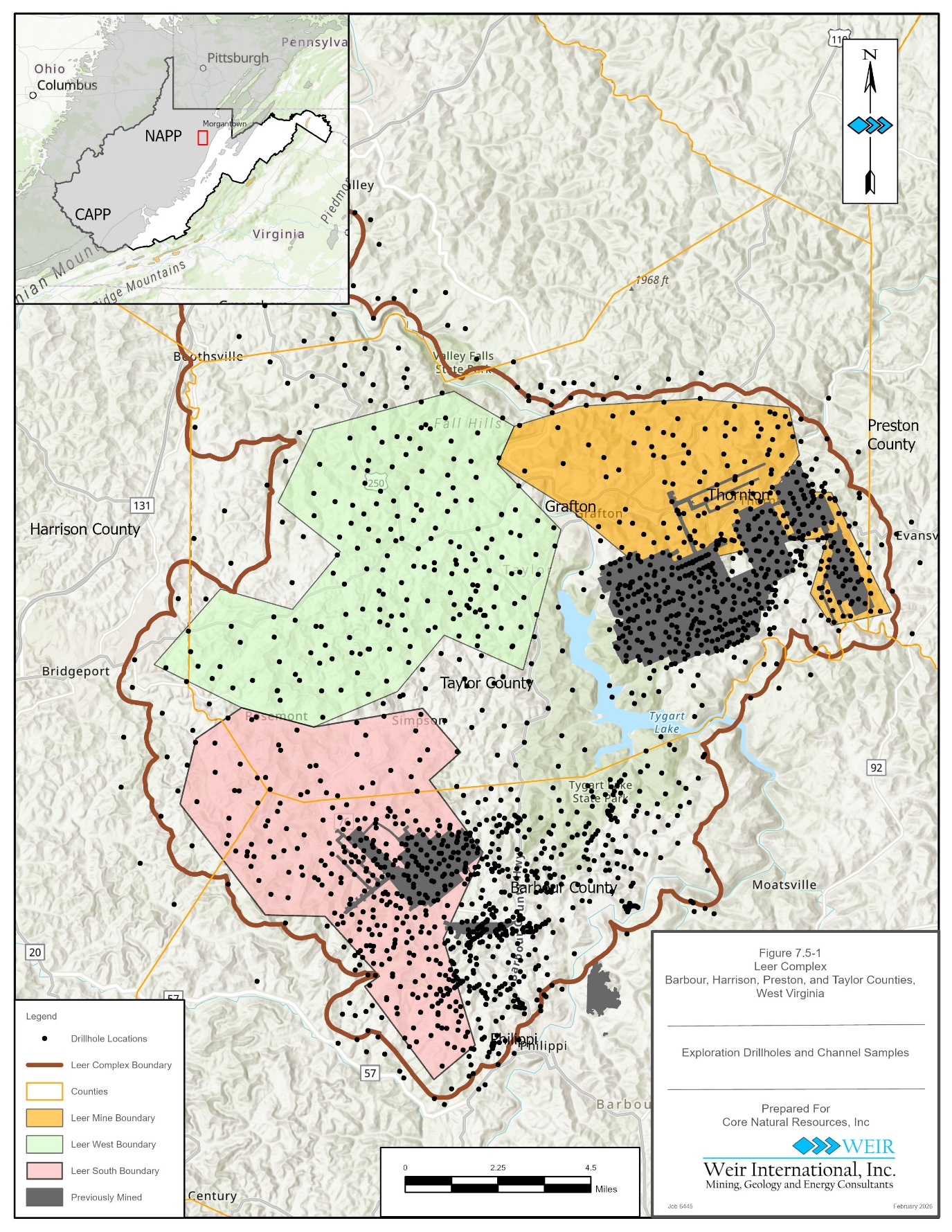
Figure 7.5-1 Drillhole Collar Locations 46
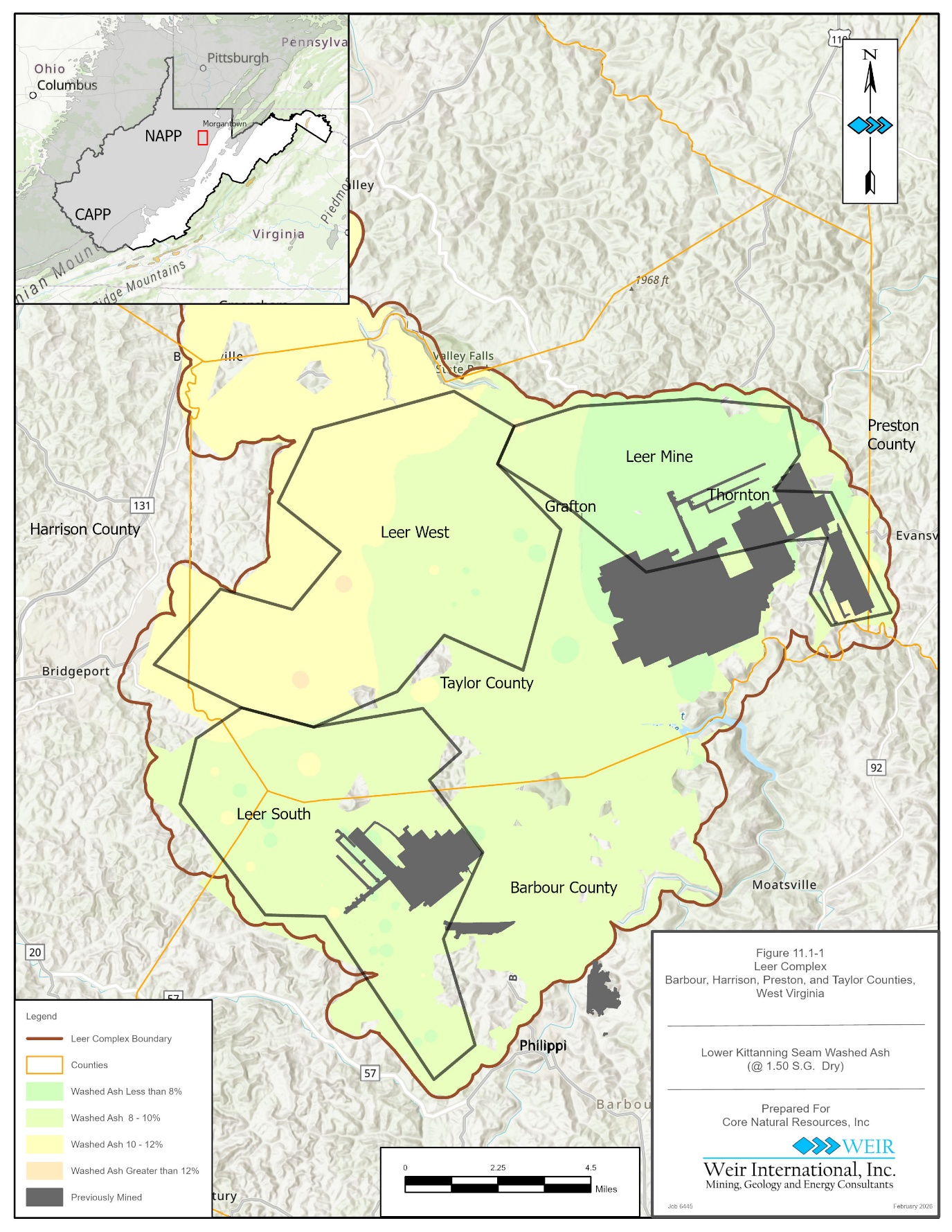
Figure 11.1-1 Washed Ash at 1.5 S.G., Dry Basis 60
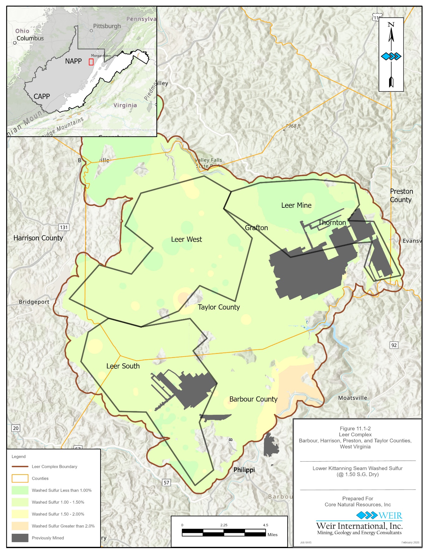
Figure 11.1-2 Washed Sulfur at 1.5 S.G., Dry Basis 61
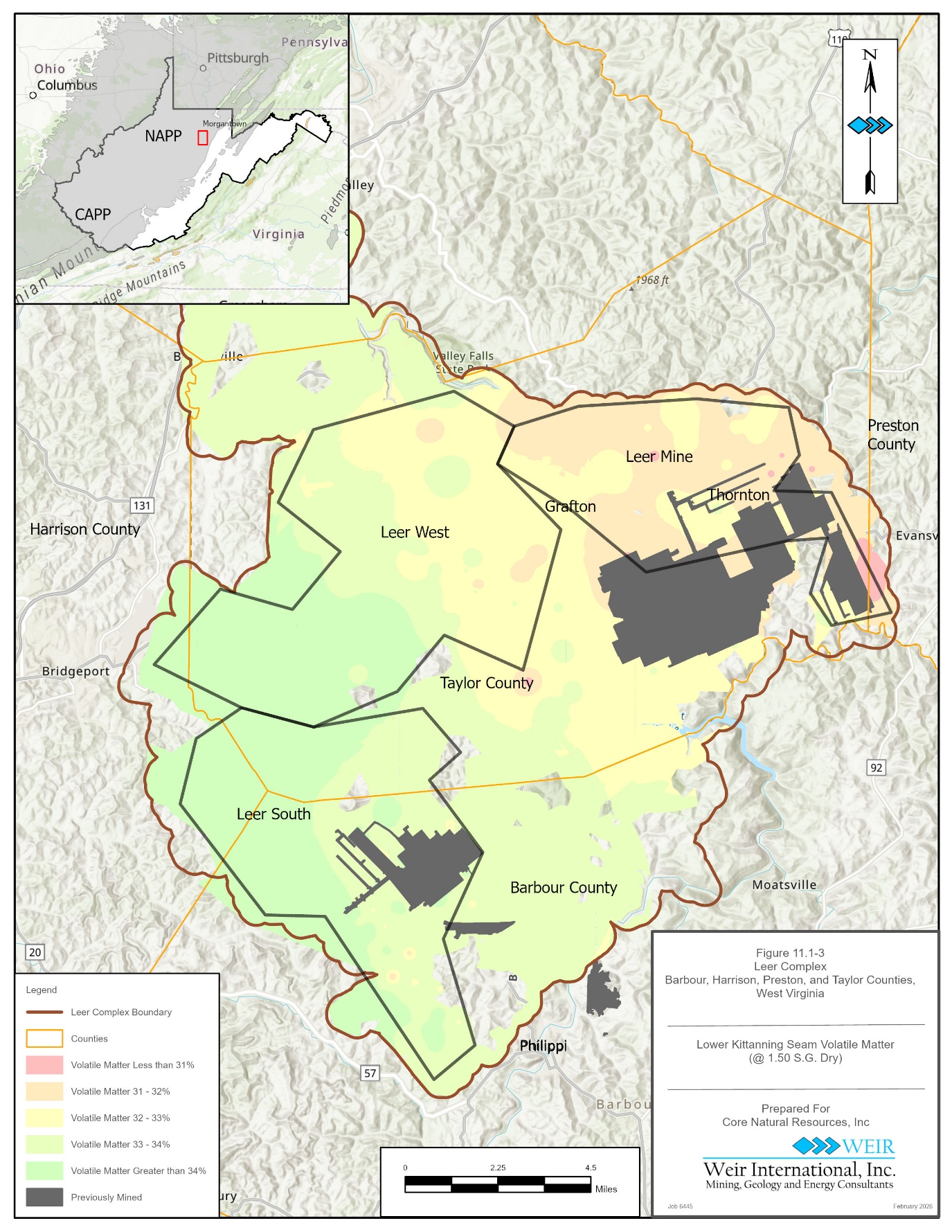
Figure 11.1-3 Volatile Matter at 1.5 S.G., Dry Basis 62
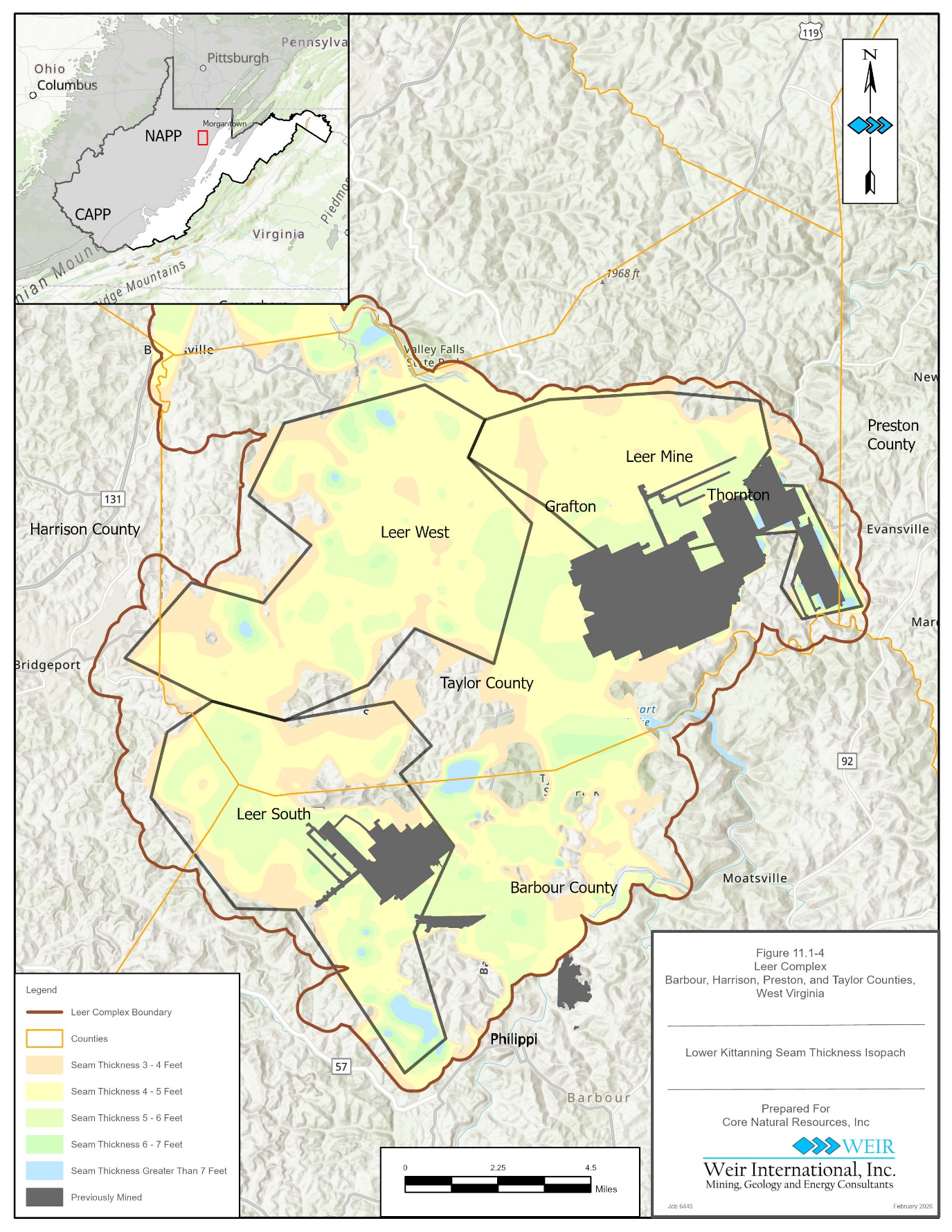
Figure 11.1-4 Lower Kittanning Seam Thickness 63
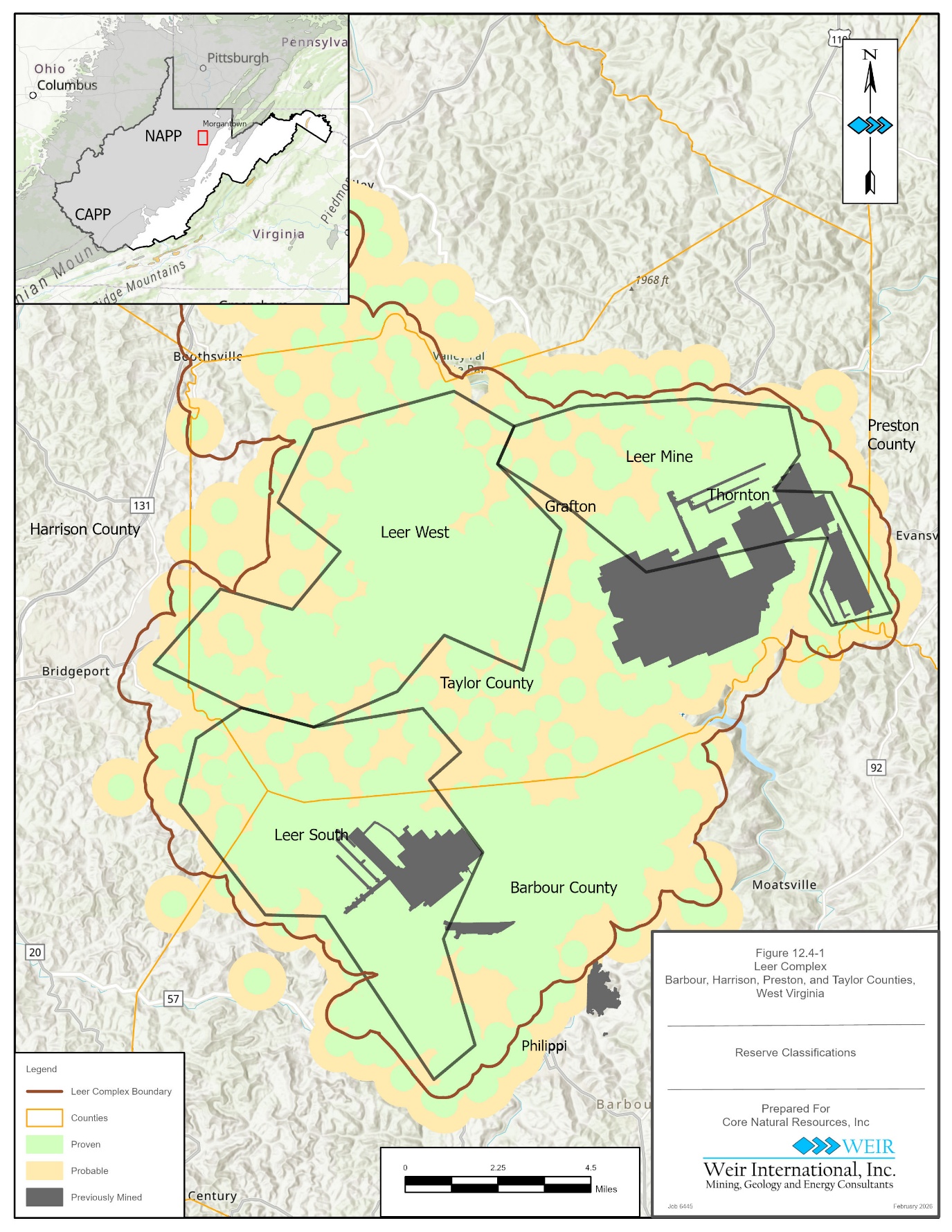
Figure 12.4-1 Reserve Classifications 77
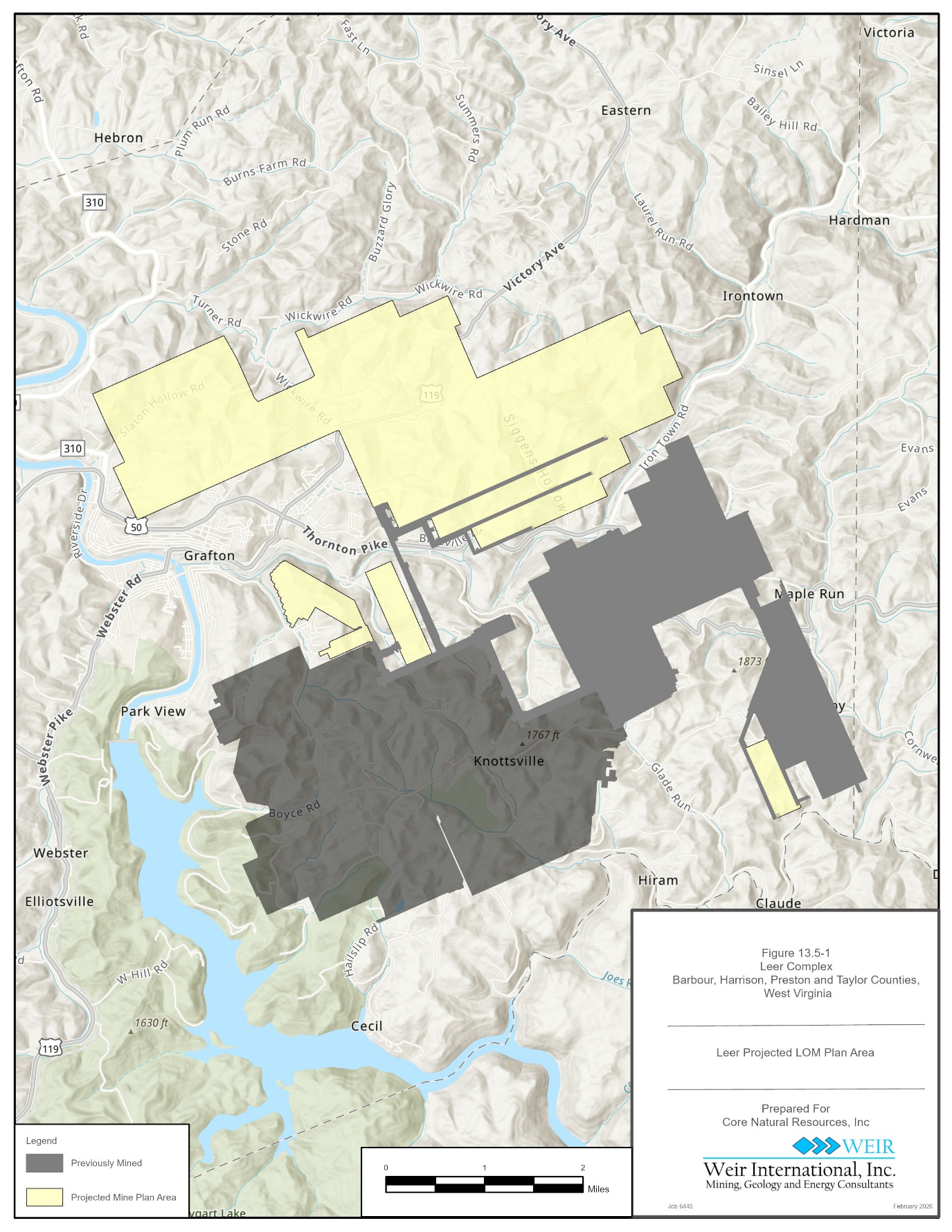
Figure 13.5-1 Leer Life of Mine Plan 96
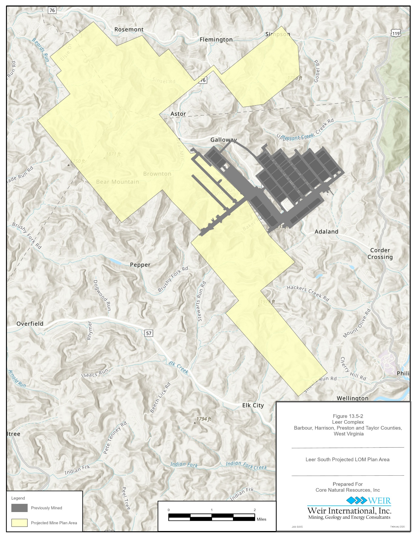
Figure 13.5-2 Leer South Life of Mine Plan 97
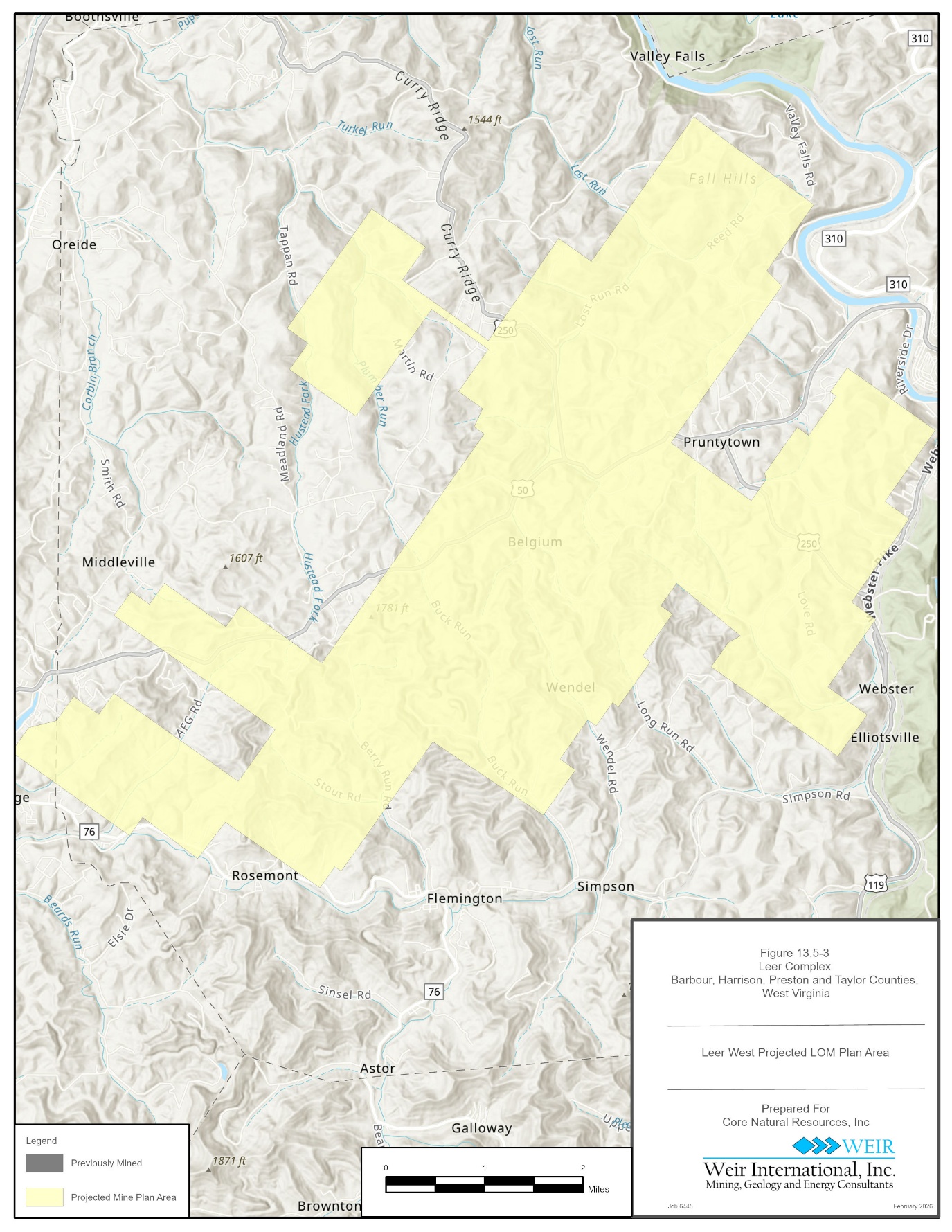
Figure 13.5-3 Leer West Mine Life of Mine Plan 98
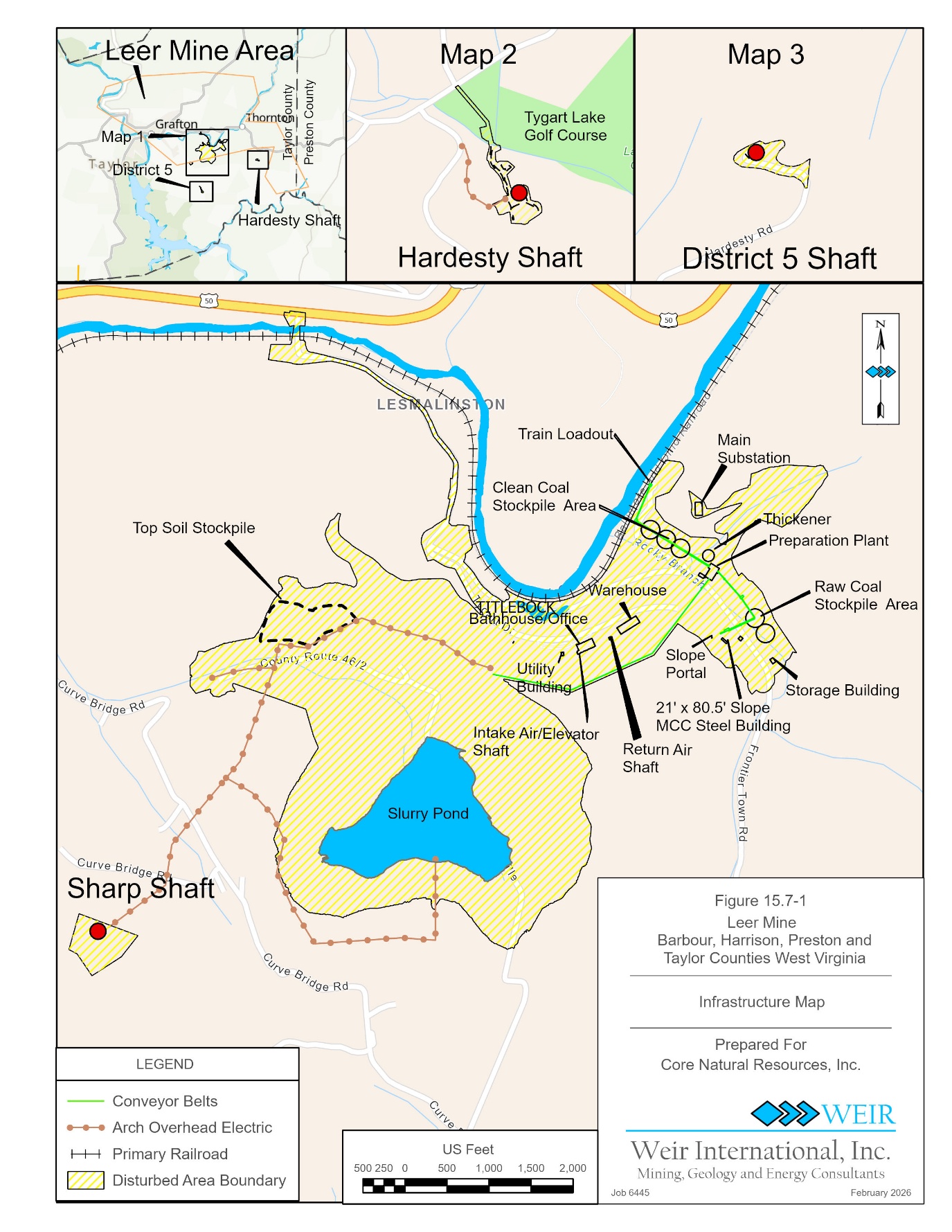
Figure 15.7-1 Leer Mine Infrastructure 107
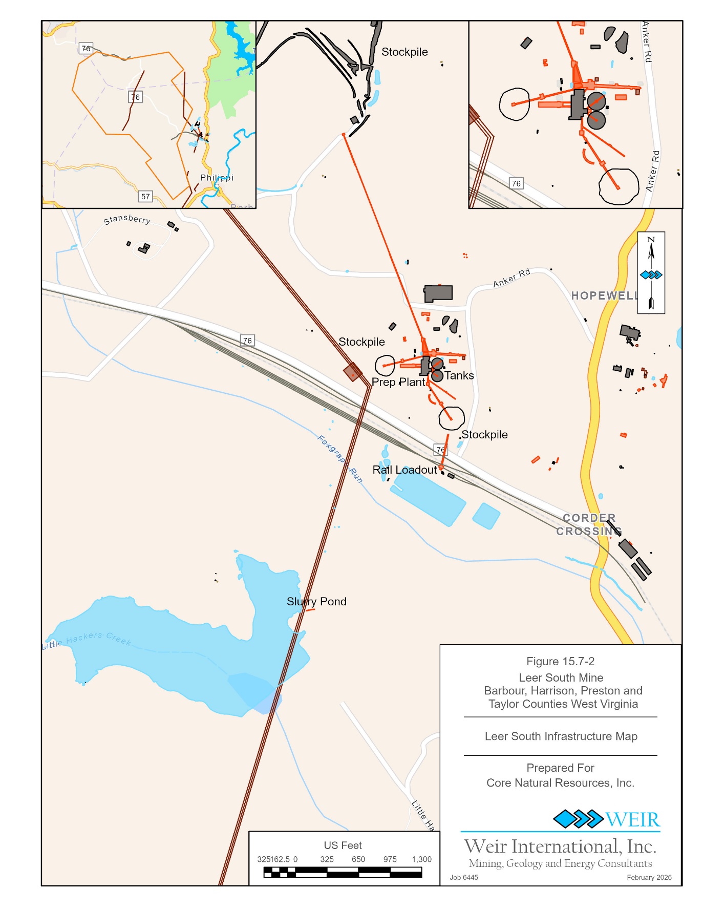
Figure 15.7-2 Leer South Mine Infrastructure 108
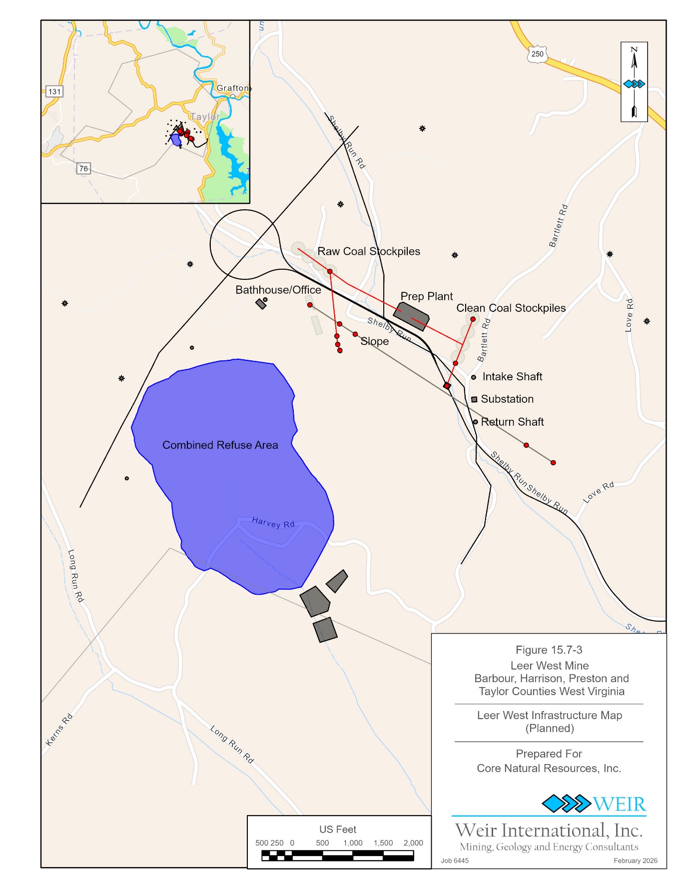
Figure 15.7-3 Leer West Mine Planned Infrastructure 109
Figure 16.1-1 Metallurgical Coal Sales Prices 111
February 6, 2026
Amended February 27, 2026 Page viii
Weir Technical Report Summary
Leer Complex
Prepared for Core Natural Resources, Inc.
Figure 16.1-2 Historical and Forecast Coal Sales Price 113
Figure 19.1-1 Coal Sales Price Forecast 128
Figure 19.2-1 Annual Cash Flow Forecast 129
Figure 19.3-1 Net Present Value Sensitivity Analysis 131
TABLES
Table 1.4-1 Leer and Leer South Mines Historical Production 6
Table 1.4-2 Typical Metallurgical Coal Product Specifications 7
Table 1.5-1 In-Place Coal Resource Tonnage and Quality Estimate as of December 31, 2025 9
Table 1.5-2 Recoverable Coal Reserve Tonnage and Quality Estimate as of December 31, 2025 10
Table 1.6-1 Key Operating Statistics 11
Table 1.7-1 Leer Complex Mining and NPDES Permits 12
Table 1.7-2 Leer Complex Permitted Area, Reclamation Liability and Bonds 13
Table 3.3-1 Property Control 22
Table 3.4-1 Lower Kittanning Seam Mineral Control Contracts 23
Table 3.5-1 Permit List 29
Table 5.2-1 Previous Exploration 35
Table 7.4-1 Geotechnical Sample Data 44
Table 7.4-2 Geotechnical Test Results 45
Table 11.1-1 Stratigraphic Model Interpolators 58
Table 11.1-2 Drillhole Statistics 58
Table 11.2-1 In-Place Coal Resource Tonnage and Quality Estimate as of December 31, 2025 65
Table 12.1-3 Recoverable Coal Reserve Tonnage and Quality Estimate as of December 31, 2025 74
Table 12.1-4 Reserve Validation 75
Table 12.5-1 Average Reserve Quality 78
Table 13.2-1 Leer Complex Historical Production Metrics 86
Table 13.2-2 Leer Complex LOM Plans Projected Clean Production 87
Table 13.4-1 Continuous Miner Section Equipment 91
Table 13.4-2 Longwall Mining Equipment 92
Table 13.4-3 Leer Mine Safety Statistics 93
Table 13.4-4 Leer Preparation Plant Safety Statistics 94
Table 13.4-5 Leer South Mine Safety Statistics 95
Table 13.4-6 Leer South Preparation Plant Safety Statistics 95
Table 14.1-1 Preparation Plant Process Size Fractions and Circuits 99
Table 16.1-1 Typical Metallurgical Coal Product Specifications 110
Table 16.2-1 Historical Coal Sales 114
Table 17.3-1 Leer Complex Mining and NPDES Permits 117
Table 17.3-2 Leer Complex Permitted Area, Reclamation Liability and Bonds 118
Table 18.1-1 Leer Complex Historical and Projected LOM Plan Capital Expenditures 121
Table 18.1-2 Leer Complex Historical and Projected LOM Plan Operating Costs 124
Table 19.2-1 After-Tax NPV, IRR Cumulative Cash Flow, and ROI 129
Table 19.2-2 Key Operating Statistics 130
Table 22.2-1 Leer Complex Risk Assessment Summary 136
Table 25.1 Information Relied Upon From Registrant 141
February 6, 2026
Amended February 27, 2026 Page ix
Weir Technical Report Summary
Leer Complex
Prepared for Core Natural Resources, Inc.
1.0 EXECUTIVE SUMMARY
Weir International, Inc. (WEIR) was retained by Core Natural Resources, Inc. (Core) to prepare the Leer Complex Technical Report Summary (TRS). This report has been prepared in accordance with the United States Securities and Exchange Commission (SEC), Regulation S-K 1300 for Mining Property Disclosure (S-K 1300) and 17 Code of Federal Regulations (CFR) § 229.601(b)(96)(iii)(B) reporting requirements.
Core (NYSE: CNR) is a world-class producer of high-quality metallurgical coal and high calorific value thermal coal for the domestic and globally traded markets. Core’s highly skilled workforce operates a best-in-sector portfolio of large-scale, low-cost longwall mines, including the Pennsylvania Mining Complex, Leer, Leer South, and West Elk mines, along with one of the world’s largest and most productive surface mines, Black Thunder. The company plays an essential role in meeting the world’s growing need for steel, infrastructure, and energy, while simultaneously serving the resurgent requirements of the United States power generation fleet. Core has an extensive and strategic logistical network, anchored by ownership positions in two East Coast marine export terminals that provide reliable and efficient access to seaborne markets. The company’s deeply ingrained culture is grounded in safety and compliance, continuous improvement, and financial performance, with an emphasis on stakeholder engagement and shareholder returns. Core was created in January 2025 via the merger of CONSOL Energy Inc. and Arch Resources, Inc. (Arch) and is based in Canonsburg, Pennsylvania.
1.1 PROPERTY DESCRIPTION
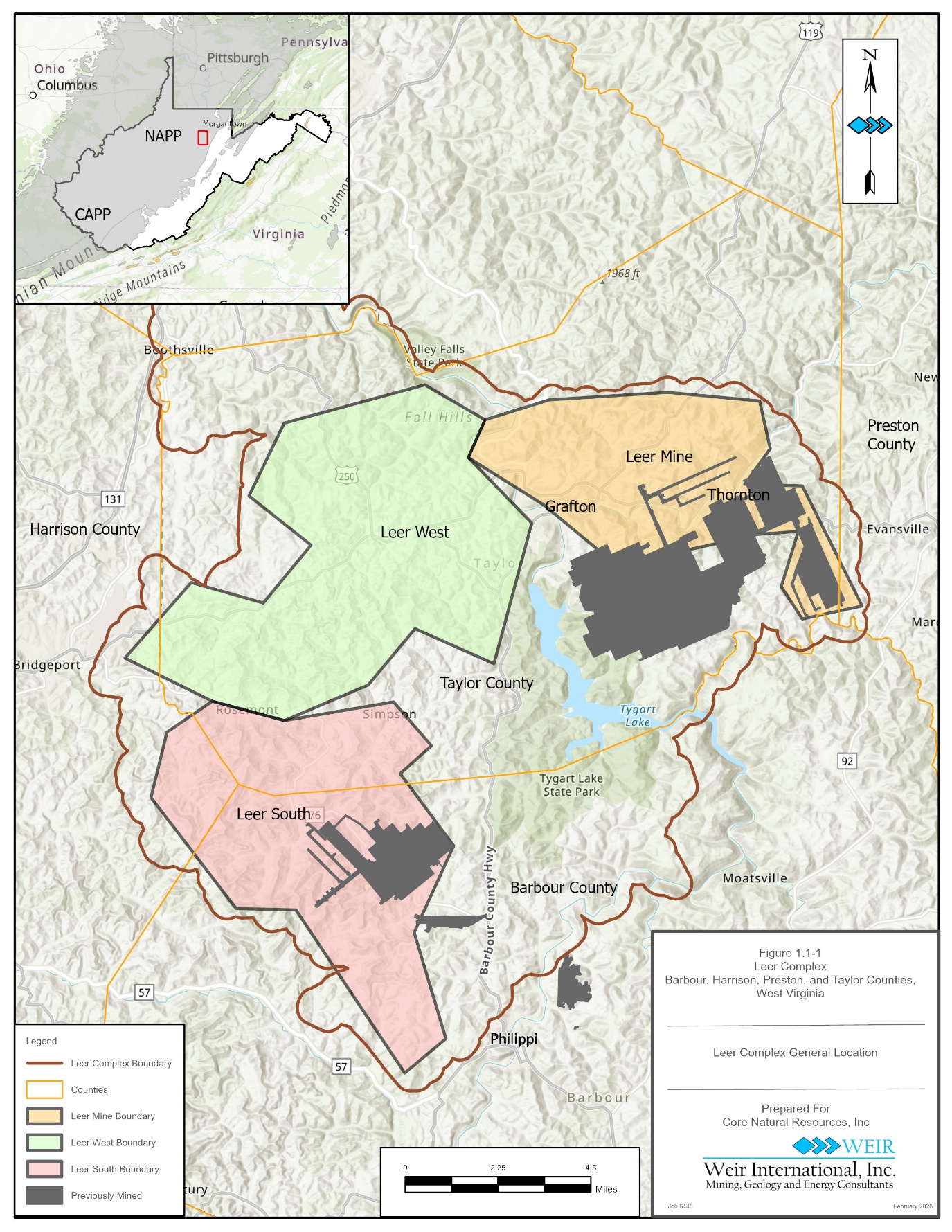
The Leer Complex is located in northern West Virginia, in Barbour, Harrison, Preston, and Taylor Counties, approximately 25 miles south of Morgantown, West Virginia, and 12 miles east of Clarksburg, West Virginia. It is developed within the Northern West Virginia coal field of the Northern Appalachia Coal Producing (NAPP) Region of the United States (see Figure 1.1-1).
The Leer Complex boundary comprises approximately 225 square miles (144,700 acres), which are a combination of owned and leased acreage. Approximately 77 percent is owned, 6 percent is leased and 17 percent is uncontrolled. Longwall mining operations of Leer, Leer South, and the future Leer West reserve are contained within the complex.
February 6, 2026
Amended February 27, 2026 1
Weir Technical Report Summary
Leer Complex
Prepared for Core Natural Resources, Inc.
Figure 1.1-1 General Location Map
February 6, 2026
Amended February 27, 2026 2
Weir Technical Report Summary
Leer Complex
Prepared for Core Natural Resources, Inc.
1.2 GEOLOGICAL SETTING AND MINERALIZATION
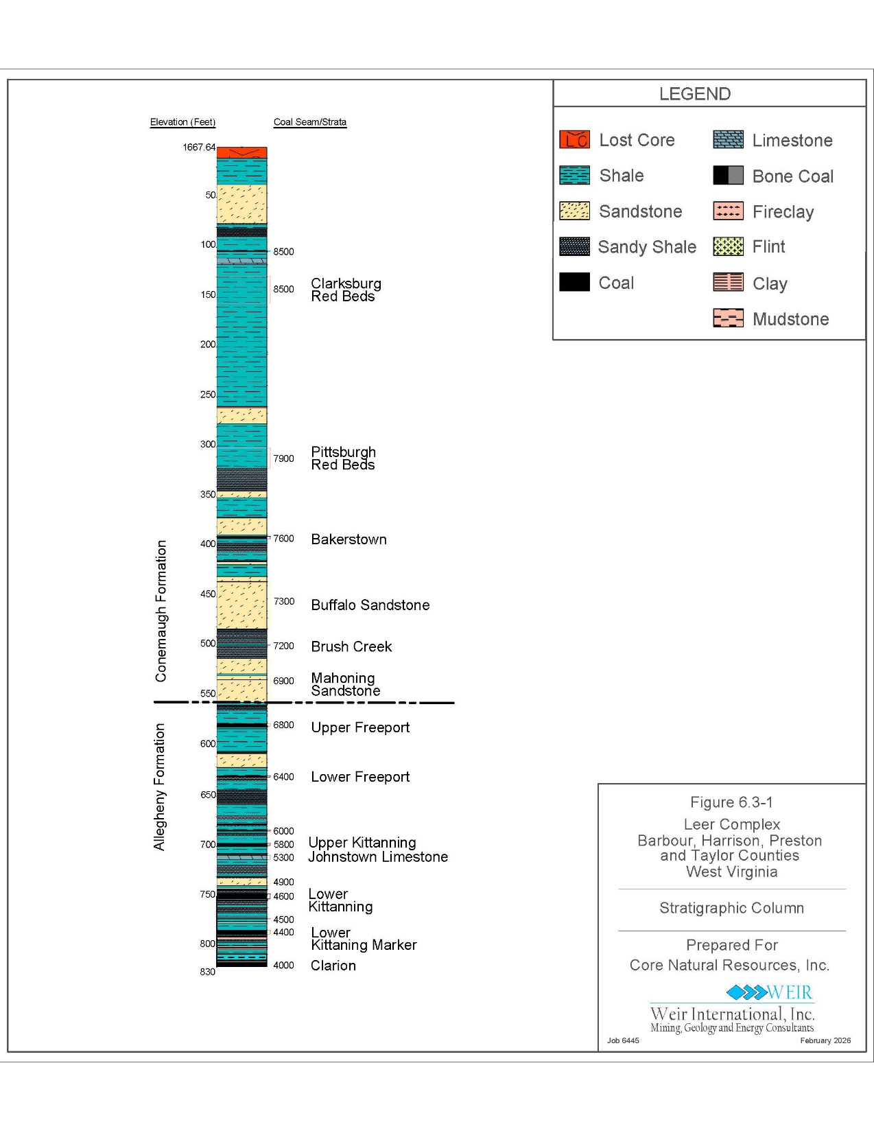
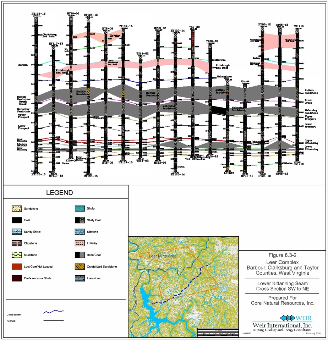
The strata of the Tygart Valley River in Barbour, Harrison, Preston, and Taylor Counties, West Virginia consists of Pennsylvanian Aged sedimentary strata of the Monongahela Group, the Conemaugh Group, and the Allegheny Formation. The Monongahela Group includes the Sewickley, Redstone, and Pittsburgh coal seams. The Pittsburgh Seam has been extensively surface and underground mined at higher elevations in the Tygart Valley River region. The Conemaugh Group coal seams include the Elk Lick, Harlem, Bakerstown, and Brush Creek. No known large-scale mining has taken place within the Conemaugh Group coal seams in the Tygart Valley River region. The Allegheny Formation includes the Upper Freeport, Lower Freeport, Upper Kittanning, Lower Kittanning, and Clarion coal seams. The Johnstown Limestone is situated between the Upper Kittanning and the Lower Kittanning coal seams. The Upper Freeport, Upper Kittanning, Lower Kittanning, and Clarion coal seams have been previously mined in the Tygart Valley River region. All other coal seams of the Allegheny Formation in the area occur in limited areal extent and are generally of insufficient thickness for mining.
The principal minable coal seam in and surrounding the Leer Complex is the Lower Kittanning Seam as this seam occurs on a larger footprint, with more pronounced seam thickness than other aforementioned coal seams throughout the property.
Leer Mine
The Leer Mine (Leer), an active longwall mine that is developed in the eastern portion of Leer Complex, and is separated from Leer West Mine (Leer West) by the Tygart River. The extent of its Lower Kittanning Seam reserve area is situated between the towns of Grafton and Thornton, West Virginia and covers an area of approximately 26 square miles (approximately 16,640 acres). Across the reserve, the Lower Kittanning Seam consists of primarily a single bench of coal (4.7 feet average thickness) but can include a rider coal. When a rider coal is present, total seam thickness can reach approximately 10.5 feet. Exploration within Leer’s reserves show that the Lower Kittanning Seam thins to less than 3.0 feet to the south, east, and locally northward.
Leer South Mine
Leer South Mine (Leer South) is an active longwall mine situated in the southern portion of Leer Complex. The Leer South reserve in the Lower Kittanning Seam is lies over portions of the old underlying Clarion Seam workings of the closed Sentinel Mine. The Leer South
February 6, 2026
Amended February 27, 2026 3
Weir Technical Report Summary
Leer Complex
Prepared for Core Natural Resources, Inc.
reserve extends over 55 square miles (approximately 35,200 acres) from near Philippi, West Virginia toward Bridgeport, West Virginia. The Lower Kittanning Seam averages 4.83 feet in thickness across its reserve area, and thins to the south and west to less than 3.0 feet.
Leer West Mine
Leer West is a planned longwall mine that is separated from Leer to the east by the Tygart River. The Leer and Leer South Life of Mine (LOM) Plan areas can both mine portions of the Leer West reserves. Leer West reserves in the Lower Kittanning Seam cover an area of approximately 63 square miles (40,320 acres) and are situated between the towns of Rosemont and Phillipi, West Virginia. The Lower Kittanning Seam averages 4.66 feet in thickness across the reserve area. The Lower Kittanning Seam thins to the north to less than 3.0 feet.
1.3 EXPLORATION
Historical exploration at the Leer Complex has relied exclusively upon continuous core drilling performed by competent contract drilling companies. Coreholes at the Leer Complex are typically 3.76-inch diameter (yielding 2.5-inch diameter core samples). Exploration drilling provides core samples of roof, coal seam, and floor strata. Core geologists utilize geophysical logs within exploration drilling to ensure strata and seam thickness accuracy over the Lower Kittanning Seam and to confirm core recovery. Drillholes with core recovery of less than 80 percent are noted and subsequently reviewed and potentially excluded from geological and coal quality modeling. WEIR did not exclude any Lower Kittanning Seam holes for poor core recovery, as all of the holes within the reserve area attained core recovery of at least 80 percent.
Coal seam core samples are sent to laboratories for quality analyses. If drill site and drillhole conditions allow, caliper, density, gamma, resistivity, and sonic downhole geophysical logs are completed. Each drillhole collar location is surveyed for accurate map coordinate and elevation data.
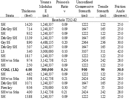
Typically, three samples of roof and one sample of floor strata from each target seam are taken for strength testing where solid unbroken lengths of core exist. Specific tests on core samples include Uniaxial Compressive Strength, Brazilian Indirect Tensile strength, Bulk Density, Specific Gravity, and Point Load index strength. Samples are prepared at a
February 6, 2026
Amended February 27, 2026 4
Weir Technical Report Summary
Leer Complex
Prepared for Core Natural Resources, Inc.
laboratory where the samples are machined into cylinders according to the appropriate American Society for Testing and Materials (ASTM) standards.
WEIR reviewed sample preparation, security, and analytical procedures for holes that were drilled after the property was acquired in 2011. It is WEIR’s opinion that the sample preparation, security, and analytical procedures utilized are acceptable and meet ASTM standards.
The adequacy of sample preparation, security, and analytical procedures utilized prior to the 2011 acquisition are generally unknown. However, the geologist’s logs for these holes contain sampling descriptions and lithologic descriptions that are sufficiently detailed to ascertain that an experienced geologist supervised the drilling and sampling. Coal quality analysis within historical exploration (prior to the 2011 acquisition) by Republic Steel, CT&E, Coal Operators Analytical Laboratory, Inc., appears to be in-line with Core’s current regiment of analyses performed by Standard Laboratories, Inc, as detailed in Section 8.0 of this TRS. However, this legacy drillhole information was included as the samples matched the coal seam intervals and reported similar quality results. Model verifications further support WEIR’s high level of confidence that a representative, valid, and accurate drillhole database and geological model has been generated for the Leer Complex that can be relied upon to accurately estimate coal resources and reserves.
1.4 OPERATIONS AND DEVELOPMENT
Leer is a permitted underground longwall mine that commenced production of metallurgical coal from the Lower Kittanning Seam in the fourth quarter of 2011. The longwall mining method has been successfully utilized in the NAPP Region, and in other coal producing regions of the United States since the 1960s. Longwall mining has the highest mining recovery of modern-day underground mining methods. Longwall mining includes room and pillar continuous mining to develop main entries, and longwall headgates and tailgates.
Leer South is a permitted underground longwall mine that commenced production of metallurgical coal from the Lower Kittanning Seam in 2018. Leer South is currently mining the Lower Kittanning Seam and parting interval within the seam, utilizing continuous miners to develop longwall panels to be mined using a longwall mining system.
February 6, 2026
Amended February 27, 2026 5
Weir Technical Report Summary
Leer Complex
Prepared for Core Natural Resources, Inc.
Leer West is a planned, permitted underground longwall mine that has not yet commenced production of metallurgical coal, as of December 31, 2025.
Historical coal production from the Leer and Leer South mines are summarized in Table 1.4-1 as follows:
Table 1.4-1 Leer and Leer South Mines Historical Production
| | | | | | | | | | | | | | |
| | 2024 | | 2025 (1) |
| Mine | | Saleable Tons (000) |
| Leer | | 3,650 | | 3,956 |
| Leer South | | 2,556 | | 307 |
| | 6,207 | | 4,264 |
| | | | |
| (1) YTD Through September 30, 2025 |
Leer South’s production in 2025 was impacted by elevated carbon monoxide levels in the longwall gob that necessitated sealing the longwall panel, which resulted in the use of continuous miners to develop a new longwall face. In December 2025, seals were breached within the affected longwall panel and all longwall face equipment was recovered and relocated to the new longwall setup face. The new longwall commenced mining on December 17, 2025.
Historically, the market for metallurgical coal from the Leer Complex has been domestic metallurgical coal consumers and the global seaborne metallurgical coal market. High volatile metallurgical coal contains more than 31 percent volatile matter and is typically represented as High Vol A and High Vol B coal. High volatile metallurgical coal, primarily High Vol A and B coals, serve both the domestic and global seaborne metallurgical coal markets. The Leer Complex mines produce and sell a High Vol A metallurgical coal product, as well as a high ash middlings product.
The typical metallurgical coal product specifications for the Leer, Leer South and planned Leer West mines are summarized in Table 1.4-2 as follows:
February 6, 2026
Amended February 27, 2026 6
Weir Technical Report Summary
Leer Complex
Prepared for Core Natural Resources, Inc.
Table 1.4-2 Typical Metallurgical Coal Product Specifications
| | | | | | | | | | | | | | | | | | | | |
| | | | Leer | | Leer |
| | Leer | | South | | West (1) |
| Moisture | %, ar | 8.5 | | 8 | | 8.5 |
| Ash | %, db | 7.5 | | 7.5 | | 7.5 |
| Vloatile Matter | %, db | 33.2 | | 33.9 | | 33.4 |
| Fixed Carbon | %, db | 59.3 | | 58.6 | | 59.1 |
| Sulfur | %, db | 1.1 | | 1.1 | | 1.1 |
| Reflectance | %Ro | 1.03 | | 1 | | 1.02 |
| Max Fluidity | DDPM | 30,000 | | | 30,000 | | | 30,000 | |
| FSI | | 8 | | 8 | | 8 |
| CSR | | 69 | | 68 | | 68 |
| | | | | | |
| (1) Projected | | | | | | |
WEIR evaluated LOM Plans for each of the Leer Complex mining operations. It is important to note that these LOM Plans are based on information provided by the company and do not contemplate the development of surrounding resource areas the company currently controls or contiguous resource areas the company could acquire in the future. Also, the plans do not assume any productivity improvements, technological innovations and/or operating efficiencies that the company has achieved historically.
The Leer LOM Plan projects mining through 2035, an expected mine life of nine years. Core projects annual mine production to range from 2.7 to 3.6 million clean tons when the longwall and three continuous miner units are operating (2026 to 2033). The continuous miner units decrease to one unit in 2034, with 2.1 million clean tons produced in 2035.
The Leer South LOM Plan projects mining through 2042, an expected mine life of 17 years. Core projects annual mine production to range from 2.7 to 4.0 million clean tons when the longwall and continuous miner units are operating (2026 to 2041), and 3.6 million clean tons in 2042 after the continuous miner units cease production.
The start date of Leer West has yet to be determined by Core. For purposes of determining economic viability of Leer West, WEIR assumed that mining would occur from 2031 through 2063; an expected mine life of 33 years. Annual mine production is projected to range from 1.9 to 3.3 million clean tons when the longwall and continuous miner units are operating (2034 to 2062), and 2.8 million clean tons in 2063 after the continuous miners cease production in 2062.
February 6, 2026
Amended February 27, 2026 7
Weir Technical Report Summary
Leer Complex
Prepared for Core Natural Resources, Inc.
All Run-of-Mine (ROM) coal from Leer is washed at the Leer Preparation Plant. The preparation plant was designed with two identical processing circuits, which can be operated simultaneously or one circuit at a time. Each circuit can process 700 ROM tons per hour (tph) for a total design feed rate of 1,400 ROM tph, although the preparation plant typically operates at 1,500 ROM tph (750 to 775 ROM tph per circuit). The preparation plant feed rate is adjusted based on the desired product quality, which often results in the preparation plant’s processing rate to be higher than its design rate.
All ROM coal from Leer South is washed at the Leer South Preparation Plant. The preparation plant was designed with two processing circuits, which can be operated simultaneously or one circuit at a time. One circuit, Circuit A, can process 600 ROM tph and the other circuit, Circuit B, can process 1,000 ROM tph for a total design feed rate of 1,600 ROM tph. The preparation plant feed rate is adjusted based on the desired product quality, which often results in the preparation plant’s processing rate to be higher than the design rate.
The ROM coal from Leer West is projected to be washed at a preparation plant yet to be constructed. The preparation plant design is likely to be similar to the Leer preparation plant, with two identical processing circuits, which can be operated simultaneously or one at a time. Each circuit is planned to process 700 ROM tons per hour (tph) of ROM coal for a total design feed rate of 1,400 ROM tph.
1.5 MINERAL RESERVE AND RESOURCE ESTIMATE
The Leer Complex coal resources, as of December 31, 2025, are summarized below and reported as in-place resources and are inclusive of reported coal reserve tons. Resources are reported in categories of Measured, Indicated and Inferred tonnage and are in accordance with Regulation S-K Item 1302(d), summarized in Table 1.5-1 as follows:
February 6, 2026
Amended February 27, 2026 8
Weir Technical Report Summary
Leer Complex
Prepared for Core Natural Resources, Inc.
Table 1.5-1 In-Place Coal Resource Tonnage and Quality Estimate as of December 31, 2025
| | | | | | | | | | | | | | | | | | | | | | | | | | | | | | | | | | | | | | | | | | | | | | | | | | | | | | | | |
| | | | | | | | | | | | | | | | | | Coal Quality |
| | | | | | | | | | | | | | | | | | (As Received) |
| | | | | | | | Average Coal | | In-Place Tons (000) | | Raw |
| Mine | | | | | | Area | | Thickness | | Resources (As Received) | | Ash |
| Area | | | | Seam | | (Acres) | | (Feet) | | Measured | | Indicated | | Total | | Inferred | | (%) |
| Leer | | Inclusive of Reserves | | Lower Kittanning | | 5,730 | | 4.7 | | 46,000 | | 8,400 | | 54,400 | | — | | 24.7 |
| Leer South | | Inclusive of Reserves | | Lower Kittanning | | 9,850 | | 4.8 | | 80,200 | | 19,300 | | 99,500 | | — | | 19.5 |
| Leer West | | Inclusive of Reserves | | Lower Kittanning | | 15,600 | | 4.7 | | 128,000 | | 26,500 | | 154,500 | | — | | 22.7 |
| | | | | | 31,180 | | 4.8 | | 254,200 | | 54,200 | | 308,400 | | | | 22.0 |
Notes:
•All Mineral Resources reported above meet the threshold for reserve modifying factors, such as estimated economic viability, that allow for conversion to Mineral Reserves.
•Resources stated as contained within a potentially economically mineable underground mine assuming a 3.0 feet minimum seam thickness, a High Vol A coal product and middling coal product realizing an average sales price of $122.00 per ton FOB Mine, with an operating cost of $71.67 per ton.
•Numbers in the table have been rounded to reflect the accuracy of the estimate and may not sum due to rounding
The conversion of resources to reserves at Leer, Leer South, and Leer West considers the effects of projected dilution and loss of product coal quality, projected mineral prices and operating costs, regulatory compliance requirements, and mineral control to determine if the saleable coal product will be economically mineable. The design of an executable mine layout that accommodates the planned mining equipment and provides a safe underground work environment is also considered.
The coal reserve tonnage representing the economically viable tonnage controlled and uncontrolled by Core, and estimated in accordance with Regulation S-K Item 1302(e), is summarized in Table 1.5-2 as follows:
February 6, 2026
Amended February 27, 2026 9
Weir Technical Report Summary
Leer Complex
Prepared for Core Natural Resources, Inc.
Table 1.5-2 Recoverable Coal Reserve Tonnage and Quality Estimate as of December 31, 2025 | | | | | | | | | | | | | | | | | | | | | | | | | | | | | | | | | | | | | | | | | | | | | | | | | | | | | | | | | | | | | | |
| | | | | | | | | | | | | | Average Product Quality @ 1.50 S.G. (Dry Basis) | | |
| | | | | | Average Coal | | Saleable Tons (000) | | | | | | Volatile | | |
| Mine | | | | Area | | Thickness | | Reserves (As Received) | | Ash | | Sulfur | | Matter | | Overall |
| Area | | Seam | | (Acres) | | (Feet) | | Proven | | Probable | | Total | | (%) | | (%) | | (%) | | Yield (%) |
| Leer | | Lower Kittanning | | 5,730 | | 4.7 | | 24,700 | | 4,700 | | 29,400 | | 8.0 | | 1.03 | | 32.3 | | 34 |
| Leer South | | Lower Kittanning | | 9,850 | | 4.8 | | 46,400 | | 10,600 | | 57,000 | | 8.8 | | 1.23 | | 34.3 | | 39 |
| Leer West | | Lower Kittanning | | 15,600 | | 4.7 | | 69,800 | | 14,000 | | 83,800 | | 9.9 | | 1.18 | | 33.7 | | 38 |
| | | | 31,180 | | 4.7 | | 140,900 | | 29,300 | | 170,200 | | 9.3 | | 1.17 | | 33.7 | | |
Notes:
•Clean recoverable Reserve tonnage based on mining recovery of 42 percent for continuous miner mining, 100 percent for longwall mining, modeled preparation plant yield, and a 95 percent preparation plant efficiency.
•Overall Yield reported above incorporates the inclusion of out of seam dilution estimated in the LOM Plan.
•Uncontrolled tons are reported for informational purposes only and are not part of the reserves. Uncontrolled tonnages are contained within small mineral tracts which must be acquired for execution of the LOM. As such, uncontrolled tonnages are included in the LOM financial model. There are approximately 8.6 million in-place uncontrolled tons within the Leer complex that will be acquired as mining progresses.
•Mineral Reserves estimated at a High Vol A coal product and middling coal product realizing an average sales price of $122.00 per ton FOB Mine, with an operating cost of $71.67 per ton.
•Numbers in the table have been rounded to reflect the accuracy of the estimate and may not sum due to rounding.
•Mineral Reserves are reported inclusive of Mineral Resources.
•Coal quality listed includes coal that is to be processed into both the middlings product and the metallurgical product and does not represent actual shipped products, which can vary for many reasons, including variations in coal depositional characteristics, non-coal parting and Out of Seam Dilution (OSD) quality characteristics and preparation plant separation specific gravities. As part of the preparation plant processing, the poorer quality middlings product is removed from the remaining clean coal, resulting in a higher quality metallurgical product.
WEIR depleted LOM reserve tonnage by reviewing actual mine workings through November 30, 2025, and subtracting actual production, reported by Core, for the remainder of the year to arrive at reserves as of December 31, 2025.
1.6 ECONOMIC EVALUATION
WEIR prepared a Preliminary Feasibility Study (PFS) financial model in order to assess the economic viability of the Leer Complex LOM Plans. Specifically, plans were evaluated using discounted cash flow analysis, which consists of annual revenue projections for the Leer Complex LOM Plans. Cash outflows such as capital, including preproduction costs, sustaining capital costs, operating costs, transportation costs, royalties, and taxes are subtracted from the inflows to produce the annual cash flow projections. No adjustments are made for inflation, and all cash flows are in 2025 U.S. dollars. WEIR’s study was conducted
February 6, 2026
Amended February 27, 2026 10
Weir Technical Report Summary
Leer Complex
Prepared for Core Natural Resources, Inc.
on an un-levered basis, excluding costs associated with any debt servicing requirements. In its assessment of Net Present Value (NPV), WEIR utilized a discount rate of 12.5 percent.
The PFS financial model developed for use in this TRS was meant to evaluate the prospects of economic extraction of coal within the Leer Complex. This economic evaluation is not meant to represent a project valuation. Furthermore, optimization of the LOM Plans was outside of the scope of this engagement.
The projected coal sales price is based on a High Vol A benchmark for metallurgical coal of $176.96 per metric tonne. Once converted to short tons, adjusted for transportation and the inclusion of middling coal sales, the estimated LOM Plan Free on Board (FOB) Mine price is $122.00 per ton.
The results of WEIR’s PFS demonstrated an after-tax NPV of $1.3 billion for the Leer Complex LOM Plans. Key operational statistics for the LOM Plans, on an after-tax basis, are summarized in Table 1.6-1 as follows:
Table 1.6-1 Key Operating Statistics
| | | | | |
| LOM Plans |
| ROM Tons Produced (000) | 474,776 | |
| Clean Tons Produced (000) | 179,290 | |
| Preparation Plant Yield (%) | 37.8 |
| Marketable Tons Sold (000) | 180,542 | |
| |
| Cash Operating Cost (000) | 12,939,634 | |
| Capital Expenditures (000) | 1,952,635 | |
| |
| ($ Per Ton) |
| Coal Sales Realization | 122.00 |
| |
| Cash Costs | 71.67 |
| Non-cash Costs | 22.85 |
| Total Cost of Sales | 94.52 |
| |
| Profit / (Loss) | 27.48 |
| |
| EBITDA | 50.33 |
| |
| Capital Expenditures | 10.89 |
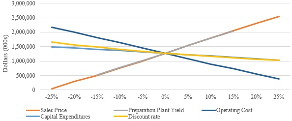
A sensitivity analysis was undertaken to examine the influence of changes to assumptions for coal sales price, preparation plant yield, operating cost, capital expenditures, and discount
February 6, 2026
Amended February 27, 2026 11
Weir Technical Report Summary
Leer Complex
Prepared for Core Natural Resources, Inc.
rate on the base case after-tax NPV. The sensitivity analysis range (±25 percent) was designed to capture the bounds of reasonable variability for each element analyzed.
The Leer Complex NPV is most sensitive to changes in coal sales price, operating cost, and preparation plant yield. It is less sensitive to changes in discount rate and capital expenditures.
1.7 ENVIRONMENTAL STUDIES AND PERMITTING REQUIREMENTS
As part of the permitting process required by the West Virginia Department of Environmental Protection (WVDEP), numerous baseline studies or impact assessments were undertaken by Core. These baseline studies or impact assessments included in the permit are summarized as follows:
•Groundwater Inventory
•Surface Water Quality and Quantity
•Probable Hydrologic Consequences
The Leer, Leer South, and planned Leer West mines have been issued mining permits, and associated NPDES permits, by the WVDEP as shown in Table 1.7-1 as follows:
Table 1.7-1 Leer Complex Mining and NPDES Permits
| | | | | | | | | | | | | | | | | | | | | | | | | | |
| | | | Permitted | | | | |
| | | | Surface | | | | |
| | | | Area | | Issue | | NPDES |
| Complex | | Permit Number | | (Acres) | | Date | | Permit No. |
| Leer | | U-2004-06 | | 201.10 | | 10/8/2025 | | WV1017764 |
| | O-2017-06 | | 315.14 | | 4/18/2022 | | WV1017764 |
| | O-2001-24 | | 251.67 | | Pending | | |
| | | | 767.91 | | | | |
| | | | | | | | |
| Leer South | | U-15-83 | | 209.45 | | 1/24/1983 | | WV0043273 |
| | O-113-83 | | 461.73 | | 8/11/1983 | | WV0043273 |
| | | | 671.18 | | | | |
| | | | | | | | |
| Leer West | | U-2006-12 | | 207.65 | | 6/22/2022 | | WV1025783 |
| | O-2001-17 | | 239.00 | | 12/10/2019 | | WV1025783 |
| | | | 446.65 | | | | |
February 6, 2026
Amended February 27, 2026 12
Weir Technical Report Summary
Leer Complex
Prepared for Core Natural Resources, Inc.
The current permit numbers, bond amounts and reclamation liability for each permit are shown in Table 1.7-2 as follows:
Table 1.7-2 Leer Complex Permitted Area, Reclamation Liability and Bonds
| | | | | | | | | | | | | | | | | | | | | | | | | | |
| | | | Permitted | | | | |
| | | | Surface | | Reclamation | | Bond |
| | Permit | | Area | | Liability (1) | | Amount |
| Complex | | Number | | (Acres) | | ($000) | | ($000) |
| Leer | | U-2004-06 | | 201.10 | | 14,217 | | 8,079 |
| | O-2017-06 | | 315.14 | | 9,349 | | 1,155 |
| | Highway Use Bonds | | — | | — | | 375 |
| | Gas Well Bond | | — | | — | | 50 |
| | | | 516.24 | | 23,566 | | 9,659 |
| | | | | | | | |
| Leer South | | U-15-83 | | 209.45 | | 5,414 | | 393 |
| | O-113-83 | | 461.73 | | 15,405 | | 1,516 |
| | Highway Use Bonds | | — | | — | | 128 |
| | Gas Well Bond | | — | | — | | 50 |
| | | | 671.18 | | 20,819 | | 2,087 |
| | | | | | | | |
| Leer West | | U-2006-12 | | 207.65 | | — | | 14 |
| | O-2001-17 | | 239.00 | | — | | 126 |
| | | | 446.65 | | | | 140 |
| | | | | | | | |
| Leer Complex | | | | 1,634 | | 44,386 | | 11,885 |
| | | | | | | | |
| (1) Represents the undiscounted cash flows to satisfy reclamation as of July 2025 |
Core currently employs approximately 425 to 500 personnel at Leer and Leer South. Hourly labor at both mines remains non-union and no change in this labor arrangement is anticipated.
The Leer Complex also creates substantial economic value with its third-party service and supply providers, utilities and through payment of taxes and fees to governmental agencies. The Leer Complex operations maintain a positive presence within the surrounding communities. As a result, the risk of community challenges to permits or operational plans is generally low. Based on WEIR’s review of Core’s plans for environmental compliance, permit compliance and conditions, and dealings with local individuals and groups, Core’s
February 6, 2026
Amended February 27, 2026 13
Weir Technical Report Summary
Leer Complex
Prepared for Core Natural Resources, Inc.
efforts appear to be adequate and reasonable in order to obtain approvals necessary relative to the execution of the Leer Complex LOM Plans.
1.8 CONCLUSIONS AND RECOMMENDATIONS
Among other United States underground mines, the Leer Complex is consistently ranked higher than average, as measured by mine productivity in tons produced per employee hour worked, as reported by the Mining Safety and Health Administration (MSHA). Additionally, Core has a long and successful operating history of resource exploration, mine development, and mining operations at Leer and Leer South mines. Extensive exploration data such as drillholes, in-mine seam thickness and elevation measurements, and in-mine channel samples support the determination of mineral resource and reserve estimates, and projected economic viability. The data has been reviewed and analyzed by WEIR and determined to be adequate in quantity and reliability to support the coal resource and coal reserve estimates in this TRS.
The LOM Plans include projected mining in a number of small tracts of land that will be encountered in later years of the LOM Plan where Core does not have mineral control. Most of these areas are expected to be acquired by Core, in adequate time, before the areas are scheduled to be mined. However, if those areas cannot be acquired, adjustments could be made to the scheduled LOM Plan to avoid those areas.
The coal resource and reserve estimates supporting the PFS were prepared in accordance with Regulation S-K 1300 requirements. There are 308.4 million in place tons of Measured and Indicated coal resources (inclusive of reserves) and 170.2 million clean recoverable tons of underground mineable reserves within the Leer Complex as of December 31, 2025.
Reasonable prospects for economic extraction were established through the development of a PFS relative to Leer, Leer South and Leer West LOM Plans. Core has not determined a commencement date for the Leer West mine, however, for the purposes of the PFS and determination of economic viability, WEIR projected the Leer West production for longwall to commence in 2031. The PFS considers historical mining performance, historical and projected metallurgical coal sales prices, historical and projected mine operating costs, and recognizing reasonable and sufficient capital expenditures.
February 6, 2026
Amended February 27, 2026 14
Weir Technical Report Summary
Leer Complex
Prepared for Core Natural Resources, Inc.
The ability of Core, or any coal company, to achieve production and financial projections is dependent on numerous factors. These factors primarily include site-specific geological conditions, the capabilities of management and mine personnel, level of success in acquiring reserves and surface properties, coal sales prices and market conditions, environmental issues, securing permits and bonds, and developing and operating mines in a safe and efficient manner. Unforeseen changes in legislation and new industry developments could substantially alter the performance of any mining company.
Coal mining is carried out in an environment where not all events are predictable. While an effective management team can identify known risks and take measures to manage and/or mitigate these risks, there is still the possibility of unexpected and unpredictable events occurring. It is not possible to totally remove all risks or state with certainty that an event that may have a material impact on the operation of a coal mine will not occur.
WEIR assessed risks associated with the economic mineability of the Leer Complex mining operations. Based on the review, these risks are low to moderate and can be managed and/or mitigated with proper planning and monitoring of the mining operations. Leer West has lower EBITDA per ton than the other mines within the complex, making its ability to achieve positive economics more dependent on anticipated coal sales prices.
WEIR recommends that any future exploration work and mineral property acquisition should include what has historically been implemented related to the following:
Geology
•Experienced geologists should log core holes, measure core recovery, and complete sampling.
•Geophysically log core holes to verify seam thickness, coal thickness, and core recovery.
•Geophysically log rotary holes to verify strata and coal thickness.
•Continue to prepare laboratory sample analysis at a 1.40, 1.50 and 1.60 specific gravity to better match the preparation plant specific gravity when processing a metallurgical coal.
•Continue collecting channel samples (include parting).
Mineral Property
•Acquire or obtain leases of uncontrolled properties prior to the projected mining date.
February 6, 2026
Amended February 27, 2026 15
Weir Technical Report Summary
Leer Complex
Prepared for Core Natural Resources, Inc.
2.0 INTRODUCTION
2.1 REGISTRANT
WEIR was retained by Core Natural Resources Inc. (NYSE: CNR) to prepare a TRS related to Core’s Leer Complex, which includes the currently operating Leer and Leer South and the planned Leer West. The Leer Complex is located approximately 25 miles south of the city of Morgantown, primarily in Barbour, Harrison, Preston and Taylor Counties, West Virginia (see Figure 1.1-1).
2.2 TERMS OF REFERENCE AND PURPOSE
This TRS was prepared specifically for Core’s Leer Complex. The Lower Kittanning Seam resources at the Leer, Leer South, and Leer West mines have been herein classified in accordance with SEC mining property disclosure rules under Subpart 1300 and Item 601 (96)(B)(iii) of Regulation S-K. Unless otherwise stated, all volumes, grades, distances, and currencies are expressed in United States customary units.
The accuracy of reserve and resource estimates are, in part, a function of the quality and quantity of available data at the time this report was prepared. Estimates presented herein are considered reasonable. However, the estimates should be accepted with the understanding that with additional data and analysis available subsequent to the date of this report, the estimates may necessitate revision which may be material. Certain information set forth in this report contains “forward-looking information”, including production, productivity, operating costs, capital costs, sales prices, and other assumptions. These statements are not guarantees of future performance and undue reliance should not be placed on this information. The assumptions used to develop the forward-looking information and the risks that could cause the actual results to differ materially are detailed in the body of this report.
Leer is a permitted underground longwall mine that commenced production of metallurgical coal in the fourth quarter of 2011. Longwall mining commenced in 2013.
Leer South is a permitted underground longwall mine that commenced production of metallurgical coal in 2018. Longwall mining commenced in August 2021.
February 6, 2026
Amended February 27, 2026 16
Weir Technical Report Summary
Leer Complex
Prepared for Core Natural Resources, Inc.
The Leer West Mine is a planned underground longwall mine that has not commenced production of metallurgical coal as of the fourth quarter of 2025.
This Leer Complex TRS reports both mineral reserves and resources (inclusive of reserves). Supporting the assessment of the economic mineability of reported reserves and prospects of economically feasible extraction of reported resources, this report includes summary detail of a PFS conducted relative to Leer, Leer South, and Leer West.
WEIR’s evaluation of coal reserves and resources was conducted in accordance with Regulation S-K 1300 definitions for Mineral Resource, Mineral Reserve, and Preliminary Feasibility Study as follows:
•Mineral Resource is a concentration or occurrence of material of economic interest in or on the earth’s crust in such form, grade or quality, and quantity that there are reasonable prospects for economic extraction. A mineral resource is a reasonable estimate of mineralization, taking into account relevant factors such as cut-off grade, likely mining dimensions, location or continuity, that with the assumed and justifiable technical and economic conditions, are likely to, in whole or in part, become economically extractable. It is not merely an inventory of all mineralization drilled or sampled.
•Mineral Reserve is an estimate of tonnage and grade or quality of indicated and measured mineral resources that, in the opinion of the Qualified Person, can be the basis of an economically viable project. More specifically, it is the economically mineable part of a measured or indicated mineral resource, which includes diluting materials and allowances for losses that may occur when the material is mined or extracted.
•Preliminary Feasibility Study is a comprehensive study of a range of options for the technical and economic viability of a mineral project that has advanced to a stage where a Qualified Person has determined (in the case of underground mining) a preferred mining method, or (in the case of surface mining) a pit configuration, and in all cases has determined an effective method of mineral processing and an effective plan to sell the product.
February 6, 2026
Amended February 27, 2026 17
Weir Technical Report Summary
Leer Complex
Prepared for Core Natural Resources, Inc.
2.3 SOURCES OF INFORMATION AND DATA
The primary information used in this study was obtained from the following sources:
•Geological data that was exclusively provided by Core geology and engineering staff. The geological data includes drillhole information such as driller’s logs, geologist’s logs, both full and partial scans of geophysical logs, survey data, coal quality laboratory certificates, and MS Excel™ (Excel) versions of drillhole survey, lithology, and quality data. Additionally, WEIR was provided with modeled coal seam floor elevations and seam thickness contours, topography contours, in-mine seam measurement thicknesses, mine channel quality samples, and other base geological data.
•Mineral and surface ownership maps, and supplemental files were provided exclusively by Ark Land LLC, a subsidiary of Core.
•Site visits by WEIR Qualified Persons (QPs) on January 28 and 29th, 2026.
•Interviews between WEIR personnel and Core personnel including
Assistant Director of Engineering - Leer and Leer South
Manager of Engineering - Leer South
Mine Manager - Leer and Leer South
Business Manager - Leer and Leer South
Geotechnical Engineer, Leer South
Geologist, Corporate
Geologist, Leer South
•Historical production, productivity, staffing levels, operating costs, capital expenditures, and coal sales revenue provided by Core.
•LOM projections and cost model provided by Core.
•Coal processing and handling facilities plot plans and flow sheets.
•Health, safety, and environmental matters discussed during interviews between WEIR and Core personnel.
•Current mine permits, in addition to recent permit revisions and renewals provided by Core.
•Current and projected mine plans, including production, productivity, operating costs, and capital expenditures required to sustain projected levels of production for the Leer Complex, provided by Core. They were all reviewed for reasonableness by WEIR.
•Market outlook and coal sales price projections provided by Core
•Projected reclamation costs for mine closure activities provided by Core.
February 6, 2026
Amended February 27, 2026 18
Weir Technical Report Summary
Leer Complex
Prepared for Core Natural Resources, Inc.
A detailed list of all data received and reviewed for this study is provided in Sections 24.0 and 25.0 of this TRS.
2.4 DETAILS OF THE PERSONAL INSPECTION OF THE PROPERTY
WEIR’s mining and geology QP’s previously visited Leer on August 17, 2021. WEIR has also performed numerous annual audits of the Leer reserves for Core’s annual SEC 10K filings.
WEIR held initial discussions with engineering management on September 3, 2025, to review questions WEIR had relative to the property’s geology, mine plans and operations. Several phone calls and meetings followed over the next three months with management, discussions included key topics as follows:
•Geology
•Property
•Infrastructure
•Mine Plan, Production and Productivity
•Preparation Plant
•Operating Costs and Capital expenditures
•Marketing
•Environmental Compliance
•Risks and Uncertainties
Subsequently, WEIR’s mining and geology QPs visited Leer South on January 28, 2026. Areas of Leer South visited included the following:
•Mine Office and Bathhouse
•Warehouse
•Preparation Plant and Stockpiles
•Rail Loadout
•Refuse Impoundment
•Underground Areas, including Longwall 9 in District 2 and Headgate 12
Areas of Leer visited by WEIR’s same QPs on January 29, 2026 included the following:
•Mine Office and Bathhouse
•Warehouse
February 6, 2026
Amended February 27, 2026 19
Weir Technical Report Summary
Leer Complex
Prepared for Core Natural Resources, Inc.
•Preparation Plant and Stockpiles
•Rail Loadout
•Refuse Impoundment
•Underground Areas, including Longwall 15 in District 8 and Headgate 4
In addition to observance of mine infrastructure, surface facilities and mining conditions, WEIR discussed the Leer, Leer South, and Leer West LOM Plans with mine management personnel.
2.5 PREVIOUS TRS
This TRS is an update to separate TRSs filed for Leer and prepared by WEIR in February 2022 and a TRS for Leer South prepared by Marshall Miller and Associates (MM&A) in February 2024, each for Arch Resources. Both previous TRSs were completed before the merger of Arch Resources and CONSOL Energy.
February 6, 2026
Amended February 27, 2026 20
Weir Technical Report Summary
Leer Complex
Prepared for Core Natural Resources, Inc.
3.0 PROPERTY DESCRIPTION
3.1 PROPERTY LOCATION
The Leer Complex is located approximately 25 miles south of Morgantown, West Virginia, primarily in Barbour, Harrison, Preston and Taylor Counties, within the Northern West Virginia coal field of the NAPP Region of the United States (see Figure 1.1-1). The approximate center point of the Leer Complex is located at 39 17’ 00”N Latitude 80 03’ 00”W Longitude. The USGS 7.5-minute quadrangle map sheets are Brownton, Fairmont East, Gladesville, Grafton, Philippi, Rosemont and Thornton.
3.2 PROPERTY AREA
The Leer Complex boundary comprises approximately 225 square miles (144,700 acres), which is a mixture of owned and leased acreage. Approximately 77 percent is owned, 6 percent is leased, and 17 percent is uncontrolled. Longwall mining operations of Leer, Leer South, and the future Leer West reserve are contained within the complex.
Leer’s surface facilities are located near the central point of its permit area. The surface facilities include mine administration, engineering and operations offices, coal preparation plant, rail loadout, mine maintenance facilities, warehouse facilities, parking lots, preparation plant waste disposal, settling ponds, and the Leer slope portal access. The total disturbed area for the surface facilities is approximately 516 acres.
Leer South’s surface facilities are located within the Leer South permit area, near the southeast portion of the permit boundary. The surface facilities include mine administration, engineering and operations offices, coal preparation plant, rail loadout, mine maintenance facilities, warehouse facilities, parking lots, preparation plant waste disposal, settling ponds, and the Leer South slope portal access. The total disturbed area for the surface facilities is approximately 400 acres.
Leer West’s surface facilities have not been constructed as of December 2025, however, the surface facilities are designed and have been included in the approved permit. A construction date has not been determined by Core, however, for the purposes of determining economic viability, WEIR has assumed a planned construction commencement in 2028. The surface facilities will include mine administration, engineering and operations offices, coal
February 6, 2026
Amended February 27, 2026 21
Weir Technical Report Summary
Leer Complex
Prepared for Core Natural Resources, Inc.
preparation plant, rail loadout, mine maintenance facilities, warehouse facilities, parking lots, preparation plant waste disposal, settling ponds, and the Leer West slope portal access. The total disturbed area for the surface facilities is approximately 239 acres.
3.3 PROPERTY CONTROL
The Leer Complex reserve boundary comprises approximately 225 square miles (144,700 acres). Within that boundary, Core controls surface and mineral rights through approximately 443 contracts. Core controls the Lower Kittanning Seam through 60 leases and 142 deeds, including commissioner’s deeds, general warranty deeds, and quitclaim deeds. A table that describes the various property control contracts is shown in Table 3.3-1. Note that each individual contract may include more than one type of property control.
Table 3.3-1 Property Control
| | | | | | | | |
| Document Type | | Quantity |
| Access Easement Agreement | | 2 |
| Aknowledgement of Rights | | 3 |
| Agreements | | 1 |
| Assignments | | 1 |
| Coal Deeds | | 13 |
| Coal Leases | | 29 |
| Deeds | | 50 |
| Easements | | 2 |
| Powerline Easements | | 12 |
| Facility Encroachment Agreement | | 4 |
| Future Refuse Storage - General Warranty Deed | | 1 |
| General Warranty Deed | | 88 |
| Leases | | 56 |
| Option to Purchase | | 7 |
| Outdeed | | 13 |
| Overriding Royalty Agreement | | 4 |
| Pipeline Right of Way | | 5 |
| Sidetrack Agreement | | 1 |
| Quit Claim Deed | | 59 |
| Quit Claim Deed - Out | | 1 |
| Right of Entry | | 2 |
| Special Commissioner's Deed | | 6 |
| Special Warranty Deed | | 9 |
| Surface Lease | | 1 |
| Surface Use and Access Agreement | | 6 |
| Track Agreement | | 1 |
| Trustee's Deed | | 1 |
| Waiver and Release of Rights | | 64 |
| Wireline Crossing Agreement | | 1 |
February 6, 2026
Amended February 27, 2026 22
Weir Technical Report Summary
Leer Complex
Prepared for Core Natural Resources, Inc.
3.4 MINERAL CONTROL
All 60 coal leases controlling the Lower Kittanning Seam, indicated above, have a minimum annual royalty payment ranging from $45 to $1,000,000 per year. Core controls other seams through additional coal leases. Core’s production royalty rates range from 1.5 percent to 10 percent of the Gross Sales Price (GSP). The details of the Lower Kittanning Seam mineral control contracts are listed in Table 3.4-1.
Table 3.4-1 Lower Kittanning Seam Mineral Control Contracts
| | | | | | | | | | | | | | | | | | | | |
| Arch Land | | Document | | | | Expiration |
| File Number | | Type | | Seams | | Date (1) |
| | | | | | |
| LN-001-1 | | Deed | | Lower Kittanning (Owned) | | N/A |
| CQT-001 | | Deed | | All seams | | N/A |
| CQT-004 | | Deed | | All seams except Pittsburgh and above | | N/A |
| LN-003 | | Coal Lease | | Lower Kittanning (Leased) | | Exhaustion of mineable and merchantable coal |
| SM-003 | | Lease | | All seams except Pittsburgh | | Exhaustion of mineable and merchantable coal |
| SM-016 | | Lease | | Percentage interest in all seams | | Exhaustion of mineable and merchantable coal |
| SM-027 | | Lease | | All seams | | Exhaustion of mineable and merchantable coal |
| SM-028 | | Lease | | Seams below level of Elk Creek are leased, which for our purposes are the Elk Lick seams and all seams below the Elk Lick (essentially all seams below the Pittsburgh seam). | | Exhaustion of mineable and merchantable coal |
| SM-033; SM-033-1 | | Leases | | All seams | | Exhaustion of mineable and merchantable coal |
| SM-033-2 | | Lease | | All seams | | Exhaustion of mineable and merchantable coal |
SM-035;
SM-035-1
(Lease Tract 1A) | | Leases | | All seams | | Exhaustion of mineable and merchantable coal |
SM-035-2;
SM-035-4
(Lease Tract 1B) | | Leases | | All seams except Pittsburgh and above | | Exhaustion of mineable and merchantable coal |
SM-035-3
(Lease Tract 2) | | Lease | | All seams | | Exhaustion of mineable and merchantable coal |
| SM-035-5 | | Lease | | All seams except Pittsburgh and above | | Exhaustion of mineable and merchantable coal |
| SM-040 | | Lease | | All seams | | Exhaustion of mineable and merchantable coal |
| SM-061 | | Lease | | Kittanning seam | | Exhaustion of mineable and merchantable coal |
| SM-062 | | Lease | | Kittanning seam | | Exhaustion of mineable and merchantable coal |
SM-065 thru
SM-065-4 | | Leases | | Percentage interest in all seams | | Exhaustion of mineable and merchantable coal |
| SM-065-5 | | Deed | | Percentage interest in all seams | | N/A |
| SM-066 | | Lease | | Upper and lower Kittanning seams | | Exhaustion of mineable and merchantable coal |
SM-068;
SM-068-1 | | Lease | | Clarion and lower Kittanning seams | | Exhaustion of mineable and merchantable coal |
| SM-073 | | Deed | | All seams | | N/A |
| SM-075 | | Deed | | All seams | | N/A |
| SM-076 | | Deed | | All seams | | N/A |
| SM-077 | | Deed | | Kittanning seam | | N/A |
| SM-078 | | Deed | | Kittanning seam | | N/A |
| SM-080 | | Deed | | Kittanning seam | | N/A |
| SM-081 | | Deed | | Most coal all seams; .85 acres of coal - Pittsburgh seam only | | N/A |
SM-083-24
(Tract Z-60) | | Leases | | All seams except Pittsburgh | | Exhaustion of mineable and merchantable coal |
SM-083-25
(Tract Z-52) | | Leases | | All seams except Pittsburgh | | Exhaustion of mineable and merchantable coal |
February 6, 2026
Amended February 27, 2026 23
Weir Technical Report Summary
Leer Complex
Prepared for Core Natural Resources, Inc.
| | | | | | | | | | | | | | | | | | | | |
| Arch Land | | Document | | | | Expiration |
| File Number | | Type | | Seams | | Date (1) |
SM-083-26
(Tract Z-62) | | Leases | | All seams except Pittsburgh | | Exhaustion of mineable and merchantable coal |
SM-083-27
(Tract Z-44) | | Leases | | All seams except Pittsburgh | | Exhaustion of mineable and merchantable coal |
SM-156 thru
SM-156-7 | | Leases | | All seams except Pittsburgh and above | | Exhaustion of mineable and merchantable coal |
| SM-159 | | Lease | | All seams except Pittsburgh and above | | Exhaustion of mineable and merchantable coal |
| SM-180 | | Lease | | All seams except Pittsburgh | | Exhaustion of mineable and merchantable coal |
| SM-196 | | Lease | | Clarion and Kittanning Seams | | Exhaustion of mineable and merchantable coal |
SM-211 thru
SM-211-2 | | Leases | | Clarion and Kittanning Seams | | 46043 |
SM-232 thru
SM-232-1 | | Leases | | All seams | | Exhaustion of mineable and merchantable coal |
SM-232-2 thru
SM-232-4 | | Deed | | All seams | | N/A |
| SM-239 | | Deed | | Lower Kittanning Seam | | N/A |
| SM-256-1 | | Coal Lease | | All Seams | | Exhaustion of mineable and merchantable coal |
| SM-270 | | Deed | | All seams except Pittsburgh | | N/A |
| SM-300 | | General Warranty Deed | | All seams | | N/A |
| SM-301 | | General Warranty Deed | | All seams | | N/A |
| SM-302 | | General Warranty Deed | | All seams | | N/A |
| SM-306 | | Coal Lease | | All seams | | Exhaustion of mineable and merchantable coal |
SM-310 thru
SM-310-1 | | Coal Lease | | All seams | | Exhaustion of mineable and merchantable coal |
| SM-313 | | Quit Claim Deed | | All seams | | N/A |
| SM-314 | | General Warranty Deed - Coal | | All seams | | N/A |
| SM-315 | | General Warranty Deed - Coal | | All seams | | N/A |
SM-316 thru
SM-316-2 | | Coal Lease | | All seams | | Exhaustion of mineable and merchantable coal |
| SM-331 | | Lease | | All seams | | Exhaustion of mineable and merchantable coal |
| SM-338 | | Lease | | All seams | | Exhaustion of mineable and merchantable coal |
| SM-340 | | Lease | | All seams | | Exhaustion of mineable and merchantable coal |
| SM-346 | | Lease | | Lower Kittanning Seam Only | | Exhaustion of mineable and merchantable coal |
| SM-349 | | Quit Claim Deed | | All seams | | N/A |
| SM-353 | | QuitClaim Deed | | All seams | | N/A |
| SR-059 | | Coal Lease | | All seams (Leased) | | Exhaustion of mineable and merchantable coal |
| TV-001 | | Lease | | Upper Freeport and all seams below | | Exhaustion of mineable and merchantable coal |
| TV-004 | | Deed | | Kittanning seams only | | N/A |
| TV-004 | | Deed | | All seams except Pittsburgh and above | | N/A |
| TV-005 | | Deed | | All seams | | N/A |
| TV-006 | | Deed | | Kittanning seams only | | N/A |
| TV-007 | | Deed | | All seams | | N/A |
| TV-036; TV-036-3 thru TV-036-21 | | Deed | | Partial ownership in all seams | | N/A |
| TV-052 | | Coal Lease | | All seams (Leased) | | Exhaustion of mineable and merchantable coal |
| TV-078 | | Deed | | All seams | | N/A |
| TV-125 | | Coal Lease | | All seams (Leased) | | Exhaustion of mineable and merchantable coal |
| TV-307 | | General Warranty Deed | | All seams | | N/A |
TV-333 thru
TV-333-2 | | Coal Lease | | All seams | | Exhaustion of mineable and merchantable coal |
TV-338 thru
TV-338-5; TV-338-8 thru TV-338-17;
TV-338-19 thru
TV-338-21; TV-338-23 thru TV-338-33 | | Coal Deed | | Partial interest in all seams
(Remainder is leased under TV-338-6, TV-338-7, and TV-338-22) | | N/A |
| TV-338-6,TV-338-7,TV-338-22 | | Coal Lease | | Partial interest in all seams
(Remainder is owned under other provisions of TV-338) | | Exhaustion of mineable and merchantable coal |
February 6, 2026
Amended February 27, 2026 24
Weir Technical Report Summary
Leer Complex
Prepared for Core Natural Resources, Inc.
| | | | | | | | | | | | | | | | | | | | |
| Arch Land | | Document | | | | Expiration |
| File Number | | Type | | Seams | | Date (1) |
| TV-343 | | Coal Lease | | All seams | | Exhaustion of mineable and merchantable coal |
| TV-355 | | Coal Lease | | All seams | | Exhaustion of mineable and merchantable coal |
| TV-356 | | Deed | | All seams | | N/A |
| TV-368 | | General Warranty Deed | | All seams | | N/A |
| TV-383-1 | | Coal Lease | | All seams | | Exhaustion of mineable and merchantable coal |
| TV-399 | | Coal Lease | | Lower Kittanning seam only | | Exhaustion of mineable and merchantable coal |
| TV-402 | | Coal Lease | | Lower Kittanning seam only | | 46538 |
| TV-404 | | Coal Lease | | All seams | | Exhaustion of mineable and merchantable coal |
| TV-410 | | Coal Lease | | All seams | | Exhaustion of mineable and merchantable coal |
| TV-410-1 | | Coal Lease | | All seams | | Exhaustion of mineable and merchantable coal |
| TV-412 | | Coal Lease | | All seams | | Exhaustion of mineable and merchantable coal |
| TV-414 | | Coal Lease | | Kittanning seams only | | Exhaustion of mineable and merchantable coal |
| TV-415 | | Quit Claim Deed | | All seams | | N/A |
| TV-415-1 | | Quit Claim Deed | | All seams | | N/A |
| TV-415-10 | | Quit Claim Deed | | All seams | | N/A |
| TV-415-11 | | Quit Claim Deed | | All seams | | N/A |
| TV-415-12 | | Quit Claim Deed | | All seams | | N/A |
| TV-415-13 | | Quit Claim Deed | | All seams | | N/A |
| TV-415-14 | | Quit Claim Deed | | All seams | | N/A |
| TV-415-15 | | Quit Claim Deed | | All seams | | N/A |
| TV-415-16 | | Quit Claim Deed | | All seams | | N/A |
| TV-415-18 | | Quit Claim Deed | | All seams | | N/A |
| TV-415-2 | | Quit Claim Deed | | All seams | | N/A |
| TV-415-20 | | Quit Claim Deed | | All seams | | N/A |
| TV-415-21 | | Quit Claim Deed | | All seams | | N/A |
| TV-415-22 | | Quit Claim Deed | | All seams | | N/A |
| TV-415-23 | | Quit Claim Deed | | All seams | | N/A |
| TV-415-24 | | Quit Claim Deed | | All seams | | N/A |
| TV-415-25 | | Quit Claim Deed | | All seams | | N/A |
| TV-415-26 | | Quit Claim Deed | | All seams | | N/A |
| TV-415-27 | | Quit Claim Deed | | All seams | | N/A |
| TV-415-28 | | Quit Claim Deed | | All seams | | N/A |
| TV-415-29 | | Quit Claim Deed | | All seams | | N/A |
| TV-415-3 | | Quit Claim Deed | | All seams | | N/A |
| TV-415-30 | | Quit Claim Deed | | All seams | | N/A |
| TV-415-31 | | Quit Claim Deed | | All seams | | N/A |
| TV-415-32 | | Quit Claim Deed | | All seams | | N/A |
| TV-415-33 | | Quit Claim Deed | | All seams | | N/A |
| TV-415-34 | | Quit Claim Deed | | All seams | | N/A |
| TV-415-35 | | Quit Claim Deed | | All seams | | N/A |
| TV-415-36 | | Quit Claim Deed | | All seams | | N/A |
| TV-415-37 | | Quit Claim Deed | | All seams | | N/A |
| TV-415-38 | | Quit Claim Deed | | All seams | | N/A |
| TV-415-39 | | Quit Claim Deed | | All seams | | N/A |
| TV-415-4 | | Quit Claim Deed | | All seams | | N/A |
| TV-415-40 | | Quit Claim Deed | | All seams | | N/A |
| TV-415-41 | | Quit Claim Deed | | All seams | | N/A |
| TV-415-42 | | Quit Claim Deed | | All seams | | N/A |
| TV-415-43 | | Quit Claim Deed | | All seams | | N/A |
| TV-415-44 | | Quit Claim Deed | | All seams | | N/A |
| TV-415-45 | | Quit Claim Deed | | All seams | | N/A |
| TV-415-46 | | Quit Claim Deed | | All seams | | N/A |
| TV-415-47 | | Coal Lease | | All seams | | Exhaustion of mineable and merchantable coal |
| TV-415-48 | | Coal Lease | | All seams | | Exhaustion of mineable and merchantable coal |
February 6, 2026
Amended February 27, 2026 25
Weir Technical Report Summary
Leer Complex
Prepared for Core Natural Resources, Inc.
| | | | | | | | | | | | | | | | | | | | |
| Arch Land | | Document | | | | Expiration |
| File Number | | Type | | Seams | | Date (1) |
| TV-415-49 | | Coal Lease | | All seams | | Exhaustion of mineable and merchantable coal |
| TV-415-5 | | Quit Claim Deed | | All seams | | N/A |
| TV-415-50 | | Coal Lease | | All seams | | Exhaustion of mineable and merchantable coal |
| TV-415-51 | | Special Commissioner's Deed | | All seams | | N/A |
| TV-415-52 | | Special Commissioner's Deed | | All seams | | N/A |
| TV-415-53 | | Special Commissioner's Deed | | All seams | | N/A |
| TV-415-54 | | Special Commissioner's Deed | | All seams | | N/A |
| TV-415-55 | | Special Commissioner's Deed | | All seams | | N/A |
| TV-415-56 | | Special Commissioner's Deed | | All seams | | N/A |
| TV-415-6 | | Quit Claim Deed | | All seams | | N/A |
| TV-415-7 | | Quit Claim Deed | | All seams | | N/A |
| TV-415-8 | | Quit Claim Deed | | All seams | | N/A |
| TV-415-9 | | Quit Claim Deed | | All seams | | N/A |
| TV-423 | | Coal Lease | | All seams | | Exhaustion of mineable and merchantable coal |
| TV-423-1 | | Coal Lease | | All seams | | Exhaustion of mineable and merchantable coal |
TV-424 thru
TV-424-2 | | Coal Lease | | All seams | | Exhaustion of mineable and merchantable coal |
| TV-429 | | Coal Lease | | All seams | | Exhaustion of mineable and merchantable coal |
| TV-455 | | Option to Purchase | | All seams | | 46106 |
| TV-458 | | Option to Purchase | | Kittanning seams and above | | 45756 |
TV-464 thru
TV-464-3 | | Coal Deed | | All seams | | N/A |
| TV-469 | | Coal Deed | | All seams | | N/A |
| CQT-001 | | Deed | | Owned coal | | N/A |
| CQT-004 | | Deed | | Owned coal | | N/A |
| CQT-006 | | Deed | | Owned coal | | N/A |
| PMC-075 | | Deed | | Owned coal and oil and gas | | N/A |
| SM-080 | | Deed | | Owned coal, oil and gas, surface, and timber | | N/A |
| SR-002 | | Deed | | Owned coal and surface | | N/A |
| SR-024 | | Deed | | Owned coal, oil and gas, surface, and timber | | N/A |
| SR-025 | | Deed for Purchase | | Owned coal and surface | | N/A |
SR-027 thru
SR-027-2 | | Deed | | Owned coal | | N/A |
| SR-029 | | Deed | | Owned coal, oil and gas, surface, and timber | | N/A |
| SR-037 | | Deed | | Owned coal and surface | | N/A |
| SR-039 | | General Warranty Deed | | Owned coal and surface | | N/A |
SR-042 thru
SR-042-1 | | Deed | | Owned coal | | N/A |
SR-050 thru
SR-050-8 | | Deed | | Owned coal | | N/A |
| SR-051 | | Deed | | Owned coal, oil and gas, surface, and timber | | N/A |
| SR-052 | | Deed | | Owned coal | | N/A |
| SR-056 | | Deed 1/3 UDI | | Owned coal (partial interest) | | N/A |
| SR-058 | | Deed | | Owned coal | | N/A |
| SR-061 | | Quitclaim Deed | | Owned coal and surface | | N/A |
| SR-062 | | Deed | | Owned coal | | N/A |
| SR-069 | | General Warranty Deed | | Owned coal and surface | | N/A |
| SR-080 | | Coal Deed | | Owned coal and surface | | N/A |
| SR-081 | | Coal Deed | | Owned coal and surface | | N/A |
| SR-082 | | Deed | | Owned coal and surface | | N/A |
| SR-086 | | Coal Deed | | Owned coal and surface | | N/A |
| SR-089 | | Quitclaim Deed | | Owned coal | | N/A |
| SR-095 | | General Warranty Deed | | Owned coal and surface | | N/A |
| SR-098 | | General Warranty Deed | | Owned coal, oil and gas, and surface | | N/A |
| SR-099 | | General Warranty Deed | | Owned coal, oil and gas, and surface | | N/A |
February 6, 2026
Amended February 27, 2026 26
Weir Technical Report Summary
Leer Complex
Prepared for Core Natural Resources, Inc.
| | | | | | | | | | | | | | | | | | | | |
| Arch Land | | Document | | | | Expiration |
| File Number | | Type | | Seams | | Date (1) |
| SR-102 | | Coal Deed | | Owned coal and surface | | N/A |
| SR-103 | | General Warranty Deed | | Owned coal, oil and gas, and surface | | N/A |
| SR-104 | | Coal Deed | | Owned coal and surface | | N/A |
| SR-105 | | Coal Deed | | Owned coal and surface | | Exhaustion of mineable and merchantable coal |
| SR-107 | | Coal Deed | | Owned coal | | N/A |
| SR-108 | | Coal Deed | | Owned coal | | N/A |
| SR-110-1 | | Quitclaim Deed | | Owned coal, oil and gas, and surface | | N/A |
| SR-110-2 | | Quitclaim Deed | | Owned coal, oil and gas, and surface | | N/A |
| SR-112 | | General Warranty Deed | | Owned coal and surface | | N/A |
| SR-113 | | Special Warranty Deed | | Owned coal and surface | | N/A |
| SR-118 | | Quit Claim Deed 86.66% interest (out of TV-004) | | Partial coal ownership | | N/A |
| SR-119 | | General Warranty Deed | | Owned coal and surface | | N/A |
| SR-126 | | General Warranty Deed | | Owned coal and surface | | N/A |
| SR-128 | | Coal Deed | | Owned coal | | N/A |
| SR-164 | | Deed | | Owned coal and surface | | N/A |
| SR-169 | | Deed | | Owned coal | | N/A |
SR-170 thru
SR-170-3 | | Deed | | Owned coal | | N/A |
| SR-172 | | General Warranty Deed | | Owned coal and surface | | N/A |
| SR-176 | | Deed | | Owned coal and surface | | N/A |
| SR-177 | | Deed | | Owned coal and surface | | N/A |
| SR-179 | | Deed | | Owned coal and surface | | N/A |
| SR-179-1 | | Deed | | Owned coal and surface | | N/A |
| SR-190 | | General Warranty Deed | | Owned coal; subsidence rights | | N/A |
SR-194 thru
SR-194-5 | | Coal Lease | | Partial lease of coal | | Exhaustion of mineable and merchantable coal |
| SR-196 | | Coal Deed | | Owned coal; subsidence rights | | N/A |
SR-226 thru
SR-226-12 | | Deed | | Partial coal ownership | | N/A |
| SR-228 | | General Warranty Deed | | Owned coal | | N/A |
| SR-234 | | Quit Claim Deed | | Owned coal | | N/A |
| TV-004 | | Deed | | Owned coal, oil and gas, surface, and timber | | N/A |
| | | | | | |
| (1) Expiration dates on leases can be extended. | | | | | | |
February 6, 2026
Amended February 27, 2026 27
Weir Technical Report Summary
Leer Complex
Prepared for Core Natural Resources, Inc.
3.5 SIGNIFICANT PROPERTY ENCUMBRANCES
Small, isolated uncontrolled properties, within all the LOM Plans will need to be acquired, by lease or purchase, to avoid the need to revise the mine plan. The tons associated with these uncontrolled properties have not been included in the reserve estimates but are listed in table 12.1.3 for informational purposes only.
Two property leases within the Leer Complex require a payment to be made based on transport of other coal (i.e. coal not mined within that lease) or refuse across the lease boundary (wheelage).
Acquisition of relatively small blocks of uncontrolled mineral resources is on-going by Core. Uncontrolled properties within a mine plan are not uncommon and are mitigated as needed or, in rare cases, the mine plans are adjusted to avoid the uncontrolled properties.
Approximately 150 acres (1.6 percent) of uncontrolled property exist within the Leer LOM Plan, approximately 685 acres (3.7 percent) of uncontrolled property exist within the Leer South LOM Plan, and approximately 965 acres (3.5 percent) of uncontrolled property exist within the Leer West LOM Plan.
WEIR is not aware of any obstacles to obtaining necessary property rights, and reasonably believes that the chances of obtaining such rights in a timely manner are highly likely. Given prior successes in Core’s property acquisition efforts, and relatively small tonnage impacts for unsuccessful reserve property acquisitions, this risk appears relatively low.
A list of Core’s permits is shown in Table 3.5-1, with a more detailed description of permits discussed in Section 17.3.
February 6, 2026
Amended February 27, 2026 28
Weir Technical Report Summary
Leer Complex
Prepared for Core Natural Resources, Inc.
Table 3.5-1 Permit List
| | | | | | | | | | | | | | | | | | | | | | | | | | |
| | | | Permitted | | | | |
| | | | Surface | | | | |
| | | | Area | | Issue | | NPDES |
| Complex | | Permit Number | | (Acres) | | Date | | Permit No. |
| Leer | | U-2004-06 | | 201.10 | | 10/8/2025 | | WV1017764 |
| | O-2017-06 | | 315.14 | | 4/18/2022 | | WV1017764 |
| | O-2001-24 | | 251.67 | | Pending | | |
| | | | 767.91 | | | | |
| | | | | | | | |
| Leer South | | U-15-83 | | 209.45 | | 1/24/1983 | | WV0043273 |
| | O-113-83 | | 461.73 | | 8/11/1983 | | WV0043273 |
| | | | 671.18 | | | | |
| | | | | | | | |
| Leer West | | U-2006-12 | | 207.65 | | 6/22/2022 | | WV1025783 |
| | O-2001-17 | | 239.00 | | 12/10/2019 | | WV1025783 |
| | | | 446.65 | | | | |
A permit amendment will be required, by January 2028, for Permit O-2017-06 to add the Rocky Branch Impoundment. Permit approval is expected in first quarter 2026. In addition to the permitting actions, reclamation surety bonds, as discussed in Section 17, are in place in accordance with West Virginia state regulations.
3.6 SIGNIFICANT PROPERTY FACTORS AND RISKS
Given Core’s controlled interests within the Leer Complex, which relate to property that is held, by and large, by Core and private individuals, WEIR assesses there are no significant issues affecting access to the coal interests or the ability of Core to execute its LOM Plans.
3.7 ROYALTY INTEREST
Core holds no royalty or similar interest in property within the Leer Complex which is owned or operated by another party.
February 6, 2026
Amended February 27, 2026 29
Weir Technical Report Summary
Leer Complex
Prepared for Core Natural Resources, Inc.
4.0 ACCESSIBILITY, CLIMATE, LOCAL RESOURCES, INFRASTRUCTURE, AND PHYSIOGRAPHY
4.1 TOPOGRAPHY, ELEVATION, AND VEGETATION
The Leer Complex is located on the Appalachian Plateau. The topography of the property consists of steep slopes, rising from the Tygart Valley River and its associated tributaries. The Tygart Valley River extends from Pocahontas County, West Virginia through Randolph, Barbour, Taylor, and Marion Counties.
The Leer property is located near the Three Fork Creek tributary of the Tygart Valley River near Grafton, West Virginia. The upper elevations consist of rolling terrain, with scattered knobs of higher elevation. The terrain drops off from the higher elevations, with steep slopes down to Three Fork Creek to the north, Tygart Lake to the west and south, and Little Sandy Creek to the southeast and east.
The Leer South property is located to the west of the Tygart River and northwest of the town of Philippi, West Virginia. The terrain drops from the higher elevations with steep slopes down to Foxgrape Run, Little Hackers Creek, Hackers Creek, and Shooks Run to the south. The drainages of Stewart Run, Spaw Lick and Brushy Fork are found to the southwest. Pleasant Creek, Simpson Creek, Camp Run, Stillhouse Run, Bartlett Run and Beards Run are located to the north.
The Leer West Property is located to the west of the Tygart Valley River, south of Pruntytown in Taylor County, West Virginia.
There are scattered areas of relatively flat lying pastureland along the river and stream floodplain terraces. Maximum relief of the property is approximately 900 feet, with elevations ranging from 1,004 feet on Three Fork Creek to 1,905 feet on an isolated knob between Stewart Run and the head of Simpson Creek. Topography and other features of the area are shown on Figure 7.5-1.
The Leer Complex consists mostly of unmanaged forestland and scattered pastureland. The forestland consists of typical West Virginia forest, with Oak/Hickory as the dominant forest-
February 6, 2026
Amended February 27, 2026 30
Weir Technical Report Summary
Leer Complex
Prepared for Core Natural Resources, Inc.
type group and a lesser percentage of the Maple/Beech/Birch forest-type group, (USDA Resource update FS-123).
4.2 PROPERTY ACCESS
The main road near Leer’s surface facilities is US Route 50, which runs east/west and is less than a mile north of the Leer facilities. The mine access road (Tygart Drive) is approximately two miles west of the small town of Thornton, West Virginia, and approximately three miles east of Grafton, West Virginia. The nearest larger towns are Morgantown, West Virginia, located approximately 25 miles to the north, and Bridgeport, West Virginia, located approximately 16 miles to the west of the property.
The main road near Leer South’s office and surface facilities is US Route 119, which runs north/south and is less than three miles north of the town of Philippi West Virginia. The nearest larger towns are Morgantown, West Virginia, located approximately 43 miles to the north, and Bridgeport, West Virginia, located approximately 26 miles to the south of the property. The distance between Leer and Leer South is approximately 15 miles via US Route 119.
The main road near Leer West is WV Route 38, south of the town of Pruntytown in Taylor County, West Virginia. The nearest larger towns are: Morgantown, West Virginia to the north (29 miles), the city of Clarksburg, West Virginia to the west, and Bridgeport, West Virginia (10.5 miles) to the west. The property can be accessed from Morgantown via WV Route 119 to WV Route 38 (Shelby Run Road) at the town of Webster. The property can be accessed from Bridgeport via WV Rt. 50 and Shelby Run Road and a new access road is planned to be constructed off of U.S. Route 250.
The Mountain Subdivision rail line, owned and operated by the CSX Railroad (CSX), passes directly by the mine surface facilities and has a separate rail loadout spur for Leer. There are dual main rail lines adjacent to the mine, which helps reduce rail line congestion. The Mountain Subdivision rail line extends from Cumberland, Maryland to Grafton, West Virginia. CSX also owns and operates a rail yard in Grafton, West Virginia.
Leer South transports coal to the CSX rail line via the Appalachian and Ohio Railroad (A&O). A&O operates 158 miles of shortline from Cowen, West Virginia to Grafton, West Virginia.
February 6, 2026
Amended February 27, 2026 31
Weir Technical Report Summary
Leer Complex
Prepared for Core Natural Resources, Inc.
Leer West plans to transport coal to the CSX line via a rail spur that will be constructed prior to the opening of the mine.
The surrounding waterways are not navigable for commercial traffic.
The nearest airport is the North Central West Virginia Airport (CKB), which is located in Bridgeport, West Virginia. The North Central West Virginia Airport is 16 miles from Grafton, West Virginia. The Morgantown Municipal Airport (MGW) is located in Morgantown, West Virginia, 35 miles from the Leer Complex.
4.3 CLIMATE AND OPERATING SEASON
The climate associated with the Leer Complex is classified as humid continental, characterized by hot, humid summers and moderately cold winters. Climate conditions vary greatly in the state of West Virginia due to the influence of rugged topography. Average high temperatures range from 82 to 87 degrees Fahrenheit in the summer, with average low temperatures ranging from 15 to 25 degrees Fahrenheit in winter. Average yearly rainfall measured in Grafton, West Virginia is 48 inches per year. Leer and Leer South currently operate year-round, regardless of weather conditions.
4.4 INFRASTRUCTURE
Power
Electrical power for Leer and Leer South is provided by a FirstEnergy Corp. subsidiary, Mon Power, through a 138 kV transmission line.
Water
The Tygart Valley River lies to the west of the Leer Mine Property and to the east of the Leer West Property. Over one half of the water required for mine operations such as mine dust suppression and preparation plant is provided by recycling. The remainder is provided by a pump station installed beside Three Fork Creek, a tributary of the Tygart Valley River, and is pumped to a million-gallon head tank. There is no contract or monthly charge for the water from Three Fork Creek. Potable water for the facilities is obtained from the Taylor County Public Service District.
February 6, 2026
Amended February 27, 2026 32
Weir Technical Report Summary
Leer Complex
Prepared for Core Natural Resources, Inc.
Water for Leer South is sourced from local streams and groundwater from an old abandoned mine. Additional water may be obtained from the toe of the refuse impoundment for use in the mine and plant.
Personnel
The northern West Virginia area surrounding Leer and Leer South has a long history of underground coal mining. Attracting mining personnel with qualified skills has not been an issue. Core currently employs between 425 to 500 personnel at both Leer and Leer South, which will continue over the LOM. The hourly labor force at both mines remains non-union and no change in this labor arrangement is anticipated. Leer West, once operating, is also projected to have approximately 425 to 500 personnel.
Supplies
Supplies for the mining operations are available from multiple vendors that service the coal industry in the NAPP Region. The main vendors utilized by Core to supply the Leer Complex include United Central Industrial Supply, Komatsu America Corp. (Joy Global), Jennmar Corporation, Strata Worldwide, Polydeck, Chemstream Inc., Richwood Industries, Inc., Conn-weld Industries, LLC, Coalfield Services Inc., Minova Global, Airtite Mine Products, LLC, Schauenburg Flexadux Corp., Contitech USA Inc., Greer Industries, Inc., and American Block Co., Inc.
February 6, 2026
Amended February 27, 2026 33
Weir Technical Report Summary
Leer Complex
Prepared for Core Natural Resources, Inc.
5.0 HISTORY
5.1 PREVIOUS OPERATIONS
Prior to the development of Leer, there was very little mining that occurred on the property. A small underground coal mine operated by the Thornton Fire Brick Company was located in the Upper Freeport Seam to the southeast of Thornton, West Virginia. This mine was located off of Three Fork Creek and operated in the early 1900s. The Thornton Fire Brick Company also operated a surface mine or “clay pit” near Thornton, West Virginia, mining fireclay for brickmaking in the early 1900s. Available maps show an underground mine, of limited extent, in the Lower Kittanning Seam to the south of Leer on the east side of Frog Run. Available data shows this as Sterling Coal Company’s Cecil coal mine, with mining shown to have occurred in the early 1900s.
Prior to the development of the Leer South, there were several mines operating within the general area. Available maps show mines along the Tygart River near the Leer South property. Available data shows the Midland Coal and Coke No. 1 mine (1905), Bar-Jay Coal’s Morral No. 1 and No. 2 Mines (1957), Ketchum Coal Company’s Mine No. 1 (1964), Johnson Coal Company (1974), and Pittston Coal Group / Badger Coal Company No. 13 and No. 14 mines (1974, 1984).
5.2 PREVIOUS EXPLORATION AND DEVELOPMENT
Prior to Core’s control of the property in 2011, previous exploration included 153 continuous drillholes drilled in proximity to Leer, 289 drillholes in proximity to the Leer South, and 166 drillholes in proximity to Leer West. There are approximately an additional 457 drillholes within the Leer Complex boundary but not within the three main areas of interest. Prior exploration activity dates back to 1922, with a list of prior companies conducting exploration, number of core holes drilled, seam thickness range, laboratories utilized for quality analysis, and dates are listed in Table 5.2-1.
February 6, 2026
Amended February 27, 2026 34
Weir Technical Report Summary
Leer Complex
Prepared for Core Natural Resources, Inc.
Table 5.2-1 Previous Exploration
| | | | | | | | | | | | | | | | | | | | |
| Company | | Drill Holes | | Quality Laboratory | | Year Drilled |
| Mohawk Smokeless Coal Company | | 1 | | None | | Unknown |
| Koppers Company | | 8 | | Unknown | | 1922 |
| Simpson Creek Collieries | | 1 | | None | | 1955 |
| Badger Coal Company | | 71 | | Badger Coal CO Lab | | 1955-1978 |
| Island Creek Coal Company | | 1 | | Island Creek Co. Lab | | 1957 |
| Eastern Gas & Fuel Associates | | 41 | | Eastern Associated Coal Corp. | | 1960-1964 |
| Mountaineer Coal Company | | 3 | | None | | 1968 |
| Tygart West Inc./Hillman Coal Corp. | | 6 | | Unknown | | 1973-1974 |
| Tygart West Inc./Atlantic Richfield Co. | | 4 | | Unknown | | 1974 |
| Bethlehem Mines Corporation | | 1 | | Bethlehem Mines Corp Chemlab | | 1975 |
| Hillman Coal Company | | 57 | | Unknown | | 1970-1987 |
| Consol Energy, Inc. | | 2 | | None | | 1977-1978 |
| Republic Steel Corporation | | 81 | | Commercial Testing and Engineering Co. | | 1978-1982 |
| Petroleum Development Corp. | | 1 | | None | | 1979 |
| Eastern Associated Coal Corp. | | 3 | | Eastern Associated Coal Corp. | | 1982 |
| Tygart West Inc./Anaconda Minerals Co. | | 29 | | Colorado School of Mines | | 1982 |
| Kitt Energy Corporation | | 10 | | None | | 1983 |
| Anker Energy | | 12 | | Unknown | | 1986-2005 |
| Unkown | | 1 | | None | | 1993 |
| Ryanstone Coal Company | | 3 | | Standard Labs, Inc. | | 2002 |
| CDX Gas, LLC | | 35 | | None | | 2004-2008 |
| International Coal Group | | 70 | | SGS | | 2005-2009 |
| Patriot Coal | | 1 | | None | | Unknown |
February 6, 2026
Amended February 27, 2026 35
Weir Technical Report Summary
Leer Complex
Prepared for Core Natural Resources, Inc.
6.0 GEOLOGICAL SETTING, MINERALIZATION, AND DEPOSIT
6.1 REGIONAL, LOCAL, AND PROPERTY GEOLOGY
6.1.1 Regional Geology
The strata of the Tygart Valley River in Barbour, Harrison, Preston, and Taylor, West Virginia consists of Pennsylvanian Aged sedimentary strata of the Monongahela Group, the Conemaugh Group, and the Allegheny Formation (see Figure 6.3-1). The gently dipping, stratiform or layered strata consists of shale, sandstone, claystone, fireclay, and coal seams. At present, economic sedimentary deposits are limited to coal seams of the Tygart Valley River. Limited scale mining of fireclay occurred in several areas near Grafton, West Virginia during the early 1900s.
The Monongahela Group includes the Sewickley, Redstone, and Pittsburgh coal seams. The Pittsburgh Seam has been extensively surface and underground mined at higher elevations in the Tygart Valley River region. The Conemaugh Group coal seams include the Elk Lick, Harlem, Bakerstown, and Brush Creek. No known large-scale mining has taken place within the Conemaugh Group coal seams in the Tygart Valley River region. The Allegheny Formation includes the Upper Freeport, Lower Freeport, Upper Kittanning, Lower Kittanning, and Clarion coal seams. The Johnstown Limestone is situated between the Upper Kittanning and Lower Kittanning coal seams. The Upper Freeport, Upper Kittanning, Lower Kittanning, and Clarion seams have been previously mined in the Tygart Valley River region. All other coal seams of the Allegheny Formation in the area occur in limited areal extent and are generally of insufficient thickness for mining.
6.1.2 Local Geology
The Monongahela Group strata is not present on the Leer property due to the lower elevations of the property. However, it is present at Leer South and Leer West. The strata present on the Leer Complex consists of the Conemaugh Group and the Allegheny Formation. All coal seams of the Conemaugh Group are thin and discontinuous. The Upper Freeport, Lower Freeport, Upper Kittanning, and Clarion coal seams are discontinuous and of limited extent on the Leer Complex property.
February 6, 2026
Amended February 27, 2026 36
Weir Technical Report Summary
Leer Complex
Prepared for Core Natural Resources, Inc.
6.1.3 Property Geology
The principal minable coal seam on the Leer Complex is the Lower Kittanning Seam, which both Leer and Leer South are actively mining. The Lower Kittanning Seam occurs in a larger area, with a higher seam thickness than all other listed seams. Leer South has also mined the Clarion Seam in the past and transports the mined Lower Kittanning Seam through the Clarion Seam to the preparation plant. The Lower Kittanning Seam reserve extends from Grafton, West Virginia south toward Phillippi, West Virginia. The Leer Complex reserve area is approximately 17 miles in length and approximately 18 miles wide.
The Lower Kittanning Seam consists primarily of a single horizon of coal with a bone coal parting, except in eastern areas of Leer where thick coal is mined due to a rider coal seam merging with the main bench. Drillholes show seam thickness ranging from 0.0 to 10.5 feet within the Leer Complex. The seam thins (< 3.0 feet) locally in pockets, to the south and east of the Leer LOM Plan and to the north and east of the northern extension of the Leer LOM Plan, as well as the western extent of both the Leer South and Leer West LOM Plans. The mineable coal seam is typically a low-ash, high thermal content, High Vol A bituminous metallurgical coal product. Parting does occur within the property and generally is between one and three feet thick. The parting does not affect the clean coal product since the coal is washed. The seam is generally continuous but is absent in areas outside the Leer Complex LOM Plans and in an area that was mined around in Leer.
6.2 MINERAL DEPOSIT TYPE AND GEOLOGICAL MODEL
The Leer Complex reserves are relatively flat lying, sedimentary deposit of Pennsylvanian Age. Leer and Leer South are actively mining a single coal seam, the Lower Kittanning. Leer West is projected to develop the Lower Kittanning Seam through longwall mining.
Exploration consists of core drilling for the Lower Kittanning Seam carried out each year in advance of mining, to refine the reserve boundary and to define limits of the mine plan. For internal purposes, Previously, reserves were modelled using the Geovia Minex® mine planning software package, completing model updates subsequent to each phase of exploration drilling. Core currently utilizes Carlson Software for geological modelling and AutoCAD for mine planning purposes. WEIR modeled the reserves and resources using
February 6, 2026
Amended February 27, 2026 37
Weir Technical Report Summary
Leer Complex
Prepared for Core Natural Resources, Inc.
Datamine MineScape® Stratmodel geological modeling software. The WEIR model is discussed in more detail in Section 9.1.
6.3 STRATIGRAPHIC COLUMN AND CROSS SECTION
Figure 6.3-1 and Figure 6.3-2 show the stratigraphic column and the Lower Kittanning Seam cross section related to the Leer Complex.
February 6, 2026
Amended February 27, 2026 38
Weir Technical Report Summary
Leer Complex
Prepared for Core Natural Resources, Inc.
Figure 6.3-1 Stratigraphic Column
February 6, 2026
Amended February 27, 2026 39
Weir Technical Report Summary
Leer Complex
Prepared for Core Natural Resources, Inc.
Figure 6.3-2 Lower Kittanning Seam Cross Section SW to NE
February 6, 2026
Amended February 27, 2026 40
Weir Technical Report Summary
Leer Complex
Prepared for Core Natural Resources, Inc.
7.0 EXPLORATION
7.1 NON-DRILLING EXPLORATION
Drilling has served as the primary form of exploration carried out at the Leer Complex. In addition, mine measurements are taken at intervals of between 100 and 300 feet throughout both Leer and Leer South. A total of 1,505 of these mine measurements were recorded. Core also provided details of 336 channel samples within Leer and Leer South. The channel samples are taken at an average interval of approximately 1,000 feet but can be as close as 100 feet in some areas. The channel samples are used in conjunction with the drillholes to model clean coal quality and therefore occur in congruence with the drill holes. The channel samples are subject to the same collection and testing procedures as surface drilling and are discussed in Section 7.2.
7.2 DRILLING
Historical exploration at the Leer Complex has relied exclusively upon continuous core drilling performed by competent contract drilling companies. Coreholes at the Leer Complex are typically 3.76-inch diameter (yielding 2.5-inch diameter core samples). Exploration drilling provides core samples of roof strata, the coal seam and floor strata. The geologist’s seam thickness measurements are checked against the geophysical logs for thickness accuracy and to confirm core recovery. A hole with significant lost core or crushed core can result in misleading data. Drillholes with core recovery of less than 80 percent are noted and subsequently reviewed and potentially excluded from geological and coal quality modeling.
WEIR did not exclude any holes for poor core recovery, as all of the holes within the project area obtained core recovery of at least 80 percent. Core’s standard procedures state that holes with less than 80 percent core recovery are re-drilled in the same boring, using a wedge above the seam, so that offset drilling of a new hole is not required. During core drilling, all core samples are boxed, photographed, and stored. Typically, 24 feet of roof and 8.0 feet of floor strata core samples are sent to laboratories for geotechnical strength tests. Coal seam core samples are sent to laboratories for quality analyses. Caliper, density, gamma, resistivity, and sonic downhole geophysical logs are completed as drill site and hole conditions allow. Each drillhole collar location is surveyed for accurate map coordinates and elevation data.
February 6, 2026
Amended February 27, 2026 41
Weir Technical Report Summary
Leer Complex
Prepared for Core Natural Resources, Inc.
All original drillhole, survey, geological, geophysical, and quality data are scanned and stored on a Core server, which is backed up nightly, so it can be accessed by select Core personnel and quickly checked against the database, the geological model, or mine mappings. The original copies are stored in an offsite warehouse.
WEIR did not have direct involvement with the planning, implementation or supervision of Core’s drilling programs. However, having reviewed the details of each drilling program, WEIR finds the results to be consistent with industry standards and sufficient for use in the estimation of reserves and resources.
WEIR did not observe core samples in person, however, Core provided photos of core logs. In review of these photos, WEIR found the cores to be representative of the data reported for each drillhole.
7.3 HYDROGEOLOGY
The Leer Complex is situated in the northern part of the Tygart Valley River watershed within the Monongahela sub-basin, both being part of the greater Ohio Regional drainage basin. Drainages in the Leer permit area include several named and unnamed, ephemeral and perennial tributaries. Three Fork Creek flows westward along the current Leer permit boundary to its confluence with the Tygart Valley River at Grafton. To the south, Sandy Creek flows west along the Taylor-Barbour County border, draining into Tygart Lake to the southwest.
Principal aquifers within the Leer permit area include the Buffalo and Mahoning sandstones at middle and lower elevations. These Pennsylvanian Age sandstones are typically confined by the less permeable Pittsburgh redbed strata capping the surrounding hilltops (see Figure 6.3-2). The Tygart Valley River and regional groundwater flow direction is generally south to north, as water in the basin drains from the higher elevations in the Allegheny Mountain Province to the lower elevations of the Appalachian Plateau. Within the Leer permit area, the gradient dips gently to northwest, with head elevation of 1,200 feet.
Core has engaged in extensive surveying to characterize site hydrogeology and to determine groundwater inventories, water quality, and potential impacts to local usage as part of its
February 6, 2026
Amended February 27, 2026 42
Weir Technical Report Summary
Leer Complex
Prepared for Core Natural Resources, Inc.
Surface Mining Control and Reclamation Act (SMCRA) permitting process with the WVDEP. Baseline flow and quality parameters for surface and groundwater inventory have been established and monitored as required by WVDEP since 2005.
Groundwater inventories, water quality data, water balance, recharge and seepage rates have been reviewed in the approved permit and current permit revisions, including hydrologic impact assessments outlining risks, monitoring program detail, and mitigation obligations. Core’s approach to obtaining and managing its surface and groundwater data for the Leer Complex has been demonstrated to be adequate and aligned with regulatory requirements and standard industry practices. WEIR finds no material barriers to the continued success of the Leer Complex regarding hydrologic impact or compliance.
The Leer South mining operation in the Lower Kittanning Seam is below surface drainage. In general, the hydrogeologic system for Leer South is similar to that of longwall mining in Leer to the north. As such, longwall mining in the Lower Kittanning Seam in Leer South is expected to involve stream undermining, undermining of aquifers, and mining through coalbed methane wells. In addition, longwall mining in Leer South will occur beneath previous above-drainage mining in the Pittsburgh coal seam; however, with an average interburden thickness of approximately 800 feet between the Lower Kittanning Seam and the Pittsburgh Seam, the potential for adverse interaction is not expected.
7.4 GEOTECHNICAL DATA
During core drilling, roof and floor strata of target coal seams are boxed, photographed and stored. Typically, three samples of roof and one sample of floor strata from each target seam are taken for strength testing where solid unbroken lengths of core exist. The samples are sent to the Appalachian Mining & Engineering laboratory in Lexington, Kentucky. Specific tests ran on core samples include Uniaxial Compressive Strength, Brazilian Indirect Tensile strength, Bulk Density, Specific Gravity, and Point Load index strength. Samples are prepared at the laboratory where the samples are machined into cylinders according to the appropriate ASTM specifications. Axial strain measurements are obtained using a hydraulic testing frame under a prescribed, constant load. Bulk density and specific gravity are determined by the weight, height, and diameter of the specimen used in the uniaxial strength test. Point load index strengths are obtained using a test frame with cones either perpendicular to, or parallel with, the specimen’s bedding plane.
February 6, 2026
Amended February 27, 2026 43
Weir Technical Report Summary
Leer Complex
Prepared for Core Natural Resources, Inc.
In addition to core strength testing, downhole sonic logging is performed on drillhole sidewalls to estimate compressive strength for rock strata. Sonic logs are generated using a high frequency sonic transducer that produces high-resolution imagery and reports strata characteristics such as fractures, compaction degree, and bedding plane orientation. Where available, the sonic logs are correlated with uniaxial strength measurements made on specimens from the same drillhole to estimate compression strength of roof strata. Sonic logging is a commonly used geophysical technique that provides valuable, low-cost data for ground control design.
A sample of the geotechnical data used in a geotechnical study, Longwall Chain Pillar Design for ICG’s Tygart No. 1 Mine in the Lower Kittanning Seam (WVU Pillar Study), commissioned with West Virginia University by Core’s predecessor company that controlled the Leer Property is shown in Table 7.4-1 as follows:
Table 7.4-1 Geotechnical Sample Data
In addition to the WVU Pillar Study, Core commissioned M. Heib (Heib Study) in February 2018 to conduct geotechnical testing and analysis of core holes in the Leer and Sentinel (now Leer South) mines. The report provides information related to horizontal stresses by roof strata, horizontal strain, Brinell Hardness, fracture trend analysis, Poisson’s Ratio, uniaxial
February 6, 2026
Amended February 27, 2026 44
Weir Technical Report Summary
Leer Complex
Prepared for Core Natural Resources, Inc.
compressive strength, and Young’s Modulus. A summary of the geotechnical data is shown in Table 7.4-2, as follows:
Table 7.4-2 Geotechnical Test Results
| | | | | | | | | | | | | | | | | | | | | | | | | | | | | | | | | | | | | | | | | | | | | | | | | | | | | | | | | | | | | | |
| | | | | | | | | | | | | | | | Youngs | | Poisson's | | Unconfined |
| | | | | | | | | | Principle Stress | | | | Modulus | | Ratio | | Compressive |
| | | | | | Depth | | Azimuth | | Major | | Minor | | | | E | | ν | | Strength |
| Hole | | Sample | | Included | | (feet) | | (degrees) | | (psi) | | (psi) | | Lithology | | (psi) | | | | (psi) |
| HT101-13 | | UC-22 | | Yes | | 834.2 | | 53 | | 1,362 | | 730 | | Shale | | 2.05E+06 | | 0.17 | | 3,714 |
| HT101-13 | | UC-21 | | No | | N/A | | 120 | | — | | — | | Sandy Shale | | 3.43E+06 | | 0.01 | | 6,755 |
| HT101-13 | | UC-25 | | Yes | | 1008.3 | | 83 | | 2,873 | | 1,712 | | Shale; fossils | | 5.56E+06 | | 0.23 | | 2,867 |
| HT101-13 | | UC-32 | | No | | N/A | | 53 | | — | | — | | Shale | | 6.32E+06 | | 0.57 | | 10,426 |
| HT106-13 | | UC-30 | | Yes | | 422.7 | | 118 | | 815 | | 413 | | Shale | | 2.49E+06 | | 0.14 | | 12,746 |
| HT106-13 | | UC-37 | | Yes | | 436.6 | | 73 | | 1,555 | | 806 | | Sandy Shale | | 2.96E+06 | | 0.17 | | 10,266 |
| HT106-13 | | UC-34 | | Yes | | 498.6 | | 107 | | 1,330 | | 693 | | Sandstone w/ shale streaks | | 2.64E+06 | | 0.14 | | 11,220 |
| HT117-13 | | UC-24 | | Yes | | 359.8 | | 35 | | 385 | | 155 | | Shale | | 5.55E+06 | | 0.07 | | 5,301 |
| HT117-13 | | UC-23 | | No | | N/A | | 32 | | — | | — | | Shale | | 6.48E+06 | | 0.46 | | 8,515 |
| HT117-13 | | UC-36 | | Yes | | 422.7 | | 70 | | 2,719 | | 1,618 | | Sandy Shale | | 8.18E+06 | | 0.27 | | 6,717 |
| PD62-15 | | UC-29 | | No | | N/A | | 155 | | — | | — | | Shale | | 3.35E+06 | | 0.26 | | 4,131 |
| RM1602 | | UC-27 | | No | | N/A | | 61 | | — | | — | | Shale | | 4.51E+06 | | 0.24 | | 7,924 |
| RM1602 | | UC-26 | | No | | N/A | | 65 | | — | | — | | Gray Sandstone | | 4.46E+07 | | 0.03 | | 10,388 |
| | | | | | Average | | 78.8 | | 1,577 | | 875 | | | | | | | | |
The results of the WVU Study and Heib Study have been incorporated by Core into the mine designs for both Leer and Leer South as further described in Section 13.1.1 of this TRS.
Since 2011, Core has drilled approximately 266 core holes in the Lower Kittanning Seam in the Leer Complex. All drillholes were cored, with core samples sent to Standard Labs for quality analyses. The thickness of the Lower Kittanning Seam identified in these drillholes ranged from 0.00 to 10.5 feet.
7.5 SITE MAP AND DRILLHOLE LOCATIONS
A map showing the location of all drillholes within the Leer Complex is shown on Figure 7.5-1.
February 6, 2026
Amended February 27, 2026 45
Weir Technical Report Summary
Leer Complex
Prepared for Core Natural Resources, Inc.
Figure 7.5-1 Drillhole Collar Locations
February 6, 2026
Amended February 27, 2026 46
Weir Technical Report Summary
Leer Complex
Prepared for Core Natural Resources, Inc.
7.6 DRILLING DATA
Core generally uses Hamon Core Drilling, Inc. located in Craigsville, West Virginia to drill core holes. Downhole geophysical logging is performed by MM&A, located in Bluefield, Virginia. Coal quality analyses are currently performed by Standard Laboratories, Inc. (Standard Labs) located in Belington, West Virginia.
February 6, 2026
Amended February 27, 2026 47
Weir Technical Report Summary
Leer Complex
Prepared for Core Natural Resources, Inc.
8.0 SAMPLE PREPARATION, ANALYSES, AND SECURITY
8.1 SAMPLE PREPARATION METHODS AND QUALITY CONTROL
Relative to the drilling conducted by Core, once the target coal seam has been drilled, the coal core is pushed from the core barrel into a plastic lined wooden core box. The coal seam is measured initially by the driller, then later described by the geologist. The coal sample is then covered in plastic and the wooden box sealed. Cardboard dividers and foam tubing are used to tightly pack and cushion the coal sample within the wooden box. The coal core boxes are transported to the Core core shed at Tucker Run where the core boxes are locked in a secure building. The geologist’s seam thickness measurements are checked against the geophysical logs for thickness accuracy and to confirm core recovery. Typically within two weeks of completion of the core hole, the coal samples are removed from the wooden core boxes and placed in sealed plastic bags and shipped to the lab. The samples are coded and labeled with sample identification numbers based on drillhole id (e.g. DT2001), sample sequence (A, B, C, etc.), and sample number, (1, 2, 3 etc.). For example, DT2001A1 is the first sample from the first seam in drillhole DT2001.
Once satisfied the data reports are accurate, the quality analyses are entered into the Core coal database. Upon data entry completion, the modeling geologists export the data and inspect the data for variance from expected norms. If any data shows outside the norm for the property, the data is checked against laboratory results to ensure proper data entry. Quality data is then gridded and mapped. Any anomalies in the data mapping are investigated. If anomalies are accurate, those items are brought to the attention of the mine engineers and sales staff.
8.2 LABORATORY SAMPLE PREPARATION, ASSAYING, AND ANALYTICAL PROCEDURES
8.2.1 Standard Laboratories, Inc.
Once quality samples are bagged and labeled, the samples are delivered to an independent laboratory, Standard Labs, located in Belington, West Virginia for quality analyses. The samples are first prepared by crushing, splitting, and sizing. The analyses performed include Proximate, Washability, Ash Fusion, Ultimate, Ash Mineral, Dilatometer, Plastometer, Trace Elements, and Petrographics.
February 6, 2026
Amended February 27, 2026 48
Weir Technical Report Summary
Leer Complex
Prepared for Core Natural Resources, Inc.
Standard Labs is certified via ANSI National Accreditation Board to the ISO/IEC 17025:2017 and located at 1196 Whitman Run Road, Belington, West Virginia 26250.
8.2.2 SGS North America, Inc.
Standard Labs ships splits of the samples to another independent laboratory, SGS North America, Inc. Mineral Services Division (SGS), located in Sophia, West Virginia for petrographic analyses. Petrographic analysis provides a clear understanding of the characteristics of the coal blend and is necessary to evaluate how coking operations will impact the final product.
SGS is certified via ISO/IEC 17025:2017 by A2LA and located at 151 Eastern Drive, Sophia, West Virginia 25921.
8.3 QUALITY CONTROL PROCEDURES AND QUALITY ASSURANCE
Quality control procedures followed by Core geologists are clearly defined. Core’s field geologists take specified steps to protect sample integrity and to ensure core samples are always under Core geologist’s control. These steps include the following:
•Field geologist visits drill site every day whenever drilling is occurring
•Geologist’s log to be created for each drillhole
•Rock-quality designation (RQD) logs to be prepared for roof and floor strata for all underground mineable seams
•Each drillhole to be logged using geophysical methods
•Underground mineable seams are sonic logged if drillhole conditions allow
•Geologist to compare field geologist’s logs to the e-log data
•Geologist to compare the core samples against both field geologist’s logs and e-logs to confirm coal thickness
•All immediate roof, coal and immediate floor core are to be boxed and photographed
•Quality sample sheets to be filled out, provided to a supervisor for approval and shipped to the laboratory
•Once core samples have been analyzed, field geologists scrutinize the resulting quality data for accuracy
February 6, 2026
Amended February 27, 2026 49
Weir Technical Report Summary
Leer Complex
Prepared for Core Natural Resources, Inc.
•Based on the homogeneity of the deposit and the consistent quality of the reserve area as evidenced from the product produced from this active mine, analytical laboratories are instructed to divide the samples and retain the second split for additional analysis should the original test report any anomalies.
8.4 SAMPLE PREPARATION, SECURITY, AND ANALYTICAL PROCEDURES ADEQUACY
Core’s procedures for quality analyses provide a full range of coal quality analyses so engineers and sales staff working with the data have a complete listing of the coal seam quality for each drillhole completed by Core.
Drillhole core samples are assigned a sample ID number and a sample label is created. The label includes drillhole ID, sample ID number, and the to and from depths of the sample. The sample is then placed in a bag with the label and sealed using zip ties or tape. This is the beginning of the chain of custody. The samples do not leave the geologist’s possession once removed from the core barrel. The samples remain with the geologist or are stored in a locked facility that only Core geologists have access to, until delivery of the samples to the contracted laboratory. The delivery of the samples is carried out within two weeks of drillhole completion. Once in possession of the certified laboratory, the laboratory’s security procedures are followed. After the sample has been tested, reviewed, and accepted, the disposal of the sample is done in accordance with local state and EPA approved methods.
WEIR has determined the sample preparation, security, and analysis procedures used for the Leer Complex drillhole samples meet current coal industry standards and practices for quality testing. The laboratory results are also determined to be suitable to use for geological modeling, mineral resource estimation and economic evaluation.
February 6, 2026
Amended February 27, 2026 50
Weir Technical Report Summary
Leer Complex
Prepared for Core Natural Resources, Inc.
9.0 DATA VERIFICATION
9.1 DATA VERIFICATION PROCEDURES
Core provided WEIR copies of all drilling records in the Leer Complex, which included Excel spreadsheets, driller’s log, field geologist’s logs, quality results sheets (from the coal quality laboratories), mine measurement tables, as well as drawing files or PDFs of the e-logs. Each hole in the database was individually checked by WEIR against a copy of the driller’s and/or geologist’s log to confirm data accuracy.
Geological reviews performed by WEIR included:
•Drillhole lithology database comparison to geophysical logs
•Drillhole coal quality database comparison to quality certificates
•Channel sample coal quality database comparison to quality certificates
After completing the precursory verifications and validations described above, the drillhole data was loaded into Datamine’s MineScape® Stratmodel, a geological modeling package. MineScape provides robust error checking features during the initial data load, which include confirmations of seam continuity, total depth versus hole header file data, interval overlap, and quality sample continuity with coal seams. Once the drillhole data was loaded, a stratigraphic model was created.
Several further verifications were then possible, which include:
•Creating cross sections through the model to visually inspect if anomalies occur due to miscorrelation of seams
•Creating structural and quality contour plots to visually check for other anomalies due to faulty seam elevations or quality data entry mistakes in the drillhole database
Typical errors which may impact reserve and resource estimation relate to discrepancies in original data entry. These errors may include:
•Incorrect drillhole coordinates (including elevation)
•Mislabeled drillhole lithology
•Unnoticed erroneous quality analyses where duplicate analyses were not requested
•Unrecorded drillhole core loss
February 6, 2026
Amended February 27, 2026 51
Weir Technical Report Summary
Leer Complex
Prepared for Core Natural Resources, Inc.
WEIR conducted a detailed independent geological evaluation of data provided by Core designed to identify and correct errors of the nature listed above. Where errors are identified and cannot be successfully resolved, it is WEIR’s policy to exclude that data from the geological model. Based on its geological evaluation of data provided, WEIR did not exclude any holes within the Leer Complex.
9.2 DATA VERIFICATION LIMITATIONS
WEIR did not conduct an independent verification of property control surveys, nor has it independently surveyed the mining locations. Rather, WEIR has relied on information compiled from maps and summaries of the owned and leased property control prepared by Core. WEIR did not conduct a legal title investigation related to Core’s mineral and surface rights.
9.3 ADEQUACY OF DATA
It is WEIR’s opinion that the adequacy of sample preparation, security, and analytical procedures for drillholes that were drilled by Core after acquiring the property is acceptable and that these methods meet typical industry standards. Core employs detailed process and procedures, described in Section 8.4 of this TRS, that are followed each time a core hole is to be sampled. The Core geologist’s logs for these holes contain sampling descriptions and lithologic descriptions that are sufficiently detailed to ascertain that an experienced geologist supervised the drilling and sampling. Core coal quality analyses were performed to ASTM standards by qualified laboratories, as detailed in Section 8.0 of this TRS.
The adequacy of sample preparation, security, and analytical procedures are generally unknown for drillholes that were drilled prior to Core acquiring the property in 2011. However, the geologist’s logs for these holes contain sampling descriptions and lithologic descriptions that are sufficiently detailed to ascertain that an experienced geologist supervised the drilling and sampling. It is unknown if coal quality analyses were performed to ASTM standards by qualified laboratories, as detailed in Section 8.0 of this TRS, however, this legacy drillhole information was included as the samples matched the coal seam intervals and reported similar quality data. Model verifications further support WEIR’s high level of confidence that a representative, valid, and accurate drillhole database and geological model
February 6, 2026
Amended February 27, 2026 52
Weir Technical Report Summary
Leer Complex
Prepared for Core Natural Resources, Inc.
has been generated for the Leer Complex that can be relied upon to accurately estimate coal resources and reserves.
February 6, 2026
Amended February 27, 2026 53
Weir Technical Report Summary
Leer Complex
Prepared for Core Natural Resources, Inc.
10.0 MINERAL PROCESSING AND METALLURGICAL TESTING
10.1 MINERAL PROCESSING TESTING AND ANALYTICAL PROCEDURES
Daily sampling is performed for plant feed and all stacking points prior to shipping clean coal products. The analyses performed include moisture, ash, sulfur, and Btu/lb on both an as-received and dry basis. These results help ensure both proper plant operation and coal product classification. Coal tonnages for raw and post-processed products are estimated using standard belt scales, which are calibrated monthly against the end of month survey data summary reports.
Efficiency testing is performed on all critical preparation plant circuitry on a bi-monthly basis to help ensure proper coal and non-coal separations are occurring throughout the plant operation. This performance testing is extensive and involves measuring flow rates, pressures, moistures, reagent application rates, size fractions, specific gravities, and coal qualities at specific processing points, from raw feed all the way through products and tailings.
10.2 MINERALIZATION SAMPLE REPRESENTATION
Coal deposits originate in flat, low-lying ground within deltas, alluvial plains, and coastal systems, and as such are a relatively homogeneous, sedimentary mineral occurrence. The deposit within the Leer Complex area exhibits homogeneous characteristics and does not show any substantial variations in mineralization types or styles that would affect processing of the coal. Sample data are well representative of the deposit as a whole. Sampling, testing procedures and the labs that perform the analyis are discussed in Section 8.
10.3 RELEVANT RESULTS AND PROCESSING FACTORS
Coal recovery and resulting product quality are primary concerns for any coal preparation plant. A coal preparation plant’s recovery and resulting product quality are dependent on ROM coal quality and the efficiency at which raw ash may be removed by the preparation plant process. Tracking and adjusting throughput rates for different plant circuitry based on ROM coal feed quality is critical to plant efficiency and product quality.
February 6, 2026
Amended February 27, 2026 54
Weir Technical Report Summary
Leer Complex
Prepared for Core Natural Resources, Inc.
While variable, preparation plant recovery is projected based on modeled OSD based on well-defined seam structural grids. Projected preparation plant recovery reflects modeled changes in the ratio between mining height and coal seam height. Product qualities are expected to track closely with the modeled recovery from raw coal analysis, once adjusted for OSD material to be mined by the continuous miners and longwall.
Historical preparation plant performance from 2024 through September 2025, based on 27.6 million preparation plant feed tons, processed 10.9 million clean tons, with a resulting yield of 46.6 percent. Projected LOM Plan preparation plant recovery is estimated to range from 30.2 to 55.5 percent, averaging 40 percent over the Leer Complex LOM Plan.
10.4 DATA ADEQUACY
Core employs testing and analytical procedures in accordance with industry standards, which result in efficient preparation plant operations and provides the necessary quality control to meet product quality and quantity projections. The testing performed is sufficient to support the projected preparation plant yield and saleable product quality for the LOM Plan.
February 6, 2026
Amended February 27, 2026 55
Weir Technical Report Summary
Leer Complex
Prepared for Core Natural Resources, Inc.
11.0 MINERAL RESOURCE ESTIMATES
The coal resources, as of December 31, 2025, summarized below are reported as in-place resources and are inclusive of reported coal reserve tons (see Section 12.0 for reserve tonnage estimates). There are no resources reported exclusive of reserve tons. Resources are reported in categories of Measured, Indicated, and Inferred tonnage and in accordance with Regulation S-K Item 1302(d).
11.1 KEY ASSUMPTIONS, PARAMETERS, AND METHODS
Data Sources
Planimetric data was provided by Core in AutoCAD format and primarily included base map information such as rivers, drainages, roads, mine features, and property boundaries.
The drillhole data provided to WEIR by Core included lithology, coal quality and survey data, and was provided in different formats including Excel, ASCII files, and PDFs. Geophysical logs, coal quality certificates, driller’s logs, geologist’s logs, downhole deviation data, and drillhole survey records were provided as scanned PDF files and AutoCAD drawing files. Data was provided for 1,330 drillholes, all of which are included in the structural model.
In-mine seam thickness and floor measurement at the Leer Complex, were provided in tabular file format. These mine measurements included 1,505 data points. In-mine coal thickness data points were generally measured every 100 to 300 feet in the mined-out areas. Mine measurement data points were used to model thickness and structure but were not used as points of observations in estimating resource confidence.
Coal quality data for 625 drillholes was provided for the Leer Complex and all were used in the quality model. Data was provided in Excel format along with quality certificates in PDF format. Reasons for excluding drillhole quality samples in the modeling process included:
•Poor core recovery noted in the driller’s logs.
•Quality logs that could not be matched to a drillhole.
•The qualities listed for the hole were not relevant to the model (for example raw Btu/lb. or sulfur were supplied, but not final product Btu/lb. or sulfur). The only relevant
February 6, 2026
Amended February 27, 2026 56
Weir Technical Report Summary
Leer Complex
Prepared for Core Natural Resources, Inc.
raw values used are specific gravity and raw ash. Both are derivable from one another and have bearing on estimated in-place tons.
Geological Model
The Leer Complex geological model was constructed by using seam surface grids that were created in Datamine’s MineScape® Stratmodel (MineScape) geological modeling package.
Topography data was gridded using MineScape software and a grid cell size of 50 feet by 50 feet. Topographic contours from the USGS were provided by Core, in CAD format, in 20-foot intervals. The contours were provided in the NAD27, West Virginia North State Plane coordinate system (FIPS 4701). The gridded USGS topography contours were compared to drillhole collars, and showed that there are differences between the two sets of elevation data. On average, the drillhole collars are less than five feet above or below the USGS topography grid, with the maximum difference of 98 feet. These differences are not uncommon when comparing a national data set to localized collar elevations. For this reason, WEIR has not excluded any of the holes that have a large difference.
The Lower Kittanning Seam does outcrop near the Tygart River in the north central area within the Leer Complex.
The seam surfaces and thicknesses were created by loading the drilling and mine measurement data into MineScape and gridding the seam intercepts using a grid cell size of 50 feet by 50 feet. The parameters used to create the model are defined in the MineScape modeling schema, which is a specification of modeling rules that is created for the site. The MineScape interpolators that were used in this study are common in most mine planning software packages. The Planar interpolator is a triangulation method with extrapolation enabled. The Height interpolator is a variant on the trend surface and inverse distance interpolators. The data points are weighted, thus producing a different plane at each sample point. By using a weighting curve that is infinite at zero distance, data honoring can be assured. Due to the least squares fit, the effect of data clustering is minimized. A trend surface is used in MineScape to promote conformability for the modeled seams to regional structures such as synclines, anticlines, or seam dip. MineScape caters to using different interpolators for thickness, roofs and floors (surfaces), and the selected trend surface as they are all modeled separately. The interpolator used for each of these items is selected on the basis of appropriateness to the data sets involved, as well as modeling experience. Stratigraphic Model Interpolators are shown in Table 11.1-1 as follows:
February 6, 2026
Amended February 27, 2026 57
Weir Technical Report Summary
Leer Complex
Prepared for Core Natural Resources, Inc.
Table 11.1-1 Stratigraphic Model Interpolators
| | | | | | | | | | | | | | |
| Interpolator | | Parameter | | Power/Order |
| Planar | | Thickness | | 0 |
| Height | | Surface | | 4 |
| Planar | | Trend | | 0 |
The Lower Kittanning coal seam was the only one modeled for this TRS. Core controls several other seams above and below the Lower Kittanning Seam that were loaded into the geological model, however, resources were not estimated for these additional seams.
A summary of drilling statistics for the Lower Kittanning Seam is shown in Table 11.1-2.
Table 11.1-2 Drillhole Statistics
| | | | | | | | | | | | | | | | | | | | | | | | | | | | | | | | | | | | | | | | | | | | | | | | | | |
| | | | | | Average | | Minimum | | Maximum | | Standard |
| | In Mine | | Number of | | Thickness | | Hole | | Thickness | | Hole | | Thickness | | Deviation |
| Seam | | Plan | | Intercepts | | (Feet) | | Name | | (Feet) | | Name | | (Feet) | | (Feet) |
| Lower Kitanning | | Yes | | 1,779 | | 5.61 | | LR1907 | | 0.00 | | MML1814 | | 10.50 | | 1.16 |
The gridded structure surfaces and coal seam thicknesses were validated against drillhole information to ensure that the data was properly modeled. Inconsistencies between modeled seam surfaces and surrounding drillholes were investigated and any confirmed errors in the drillhole data or model parameters were corrected. This process was repeated until a final version of the model was developed.
Coal Quality Model
The drillhole and channel sample quality data described previously in this report were used to create a washed coal quality model that included raw ash and raw relative density. The washed quality model values were based on a specific gravity of 1.50.
The drillholes were verified to ensure that the seam depths used in the lithology file matched the sample depths in the quality file. Twenty-five holes were found to have a fully sampled interval that included the Lower Kittanning Rider Seam, parting, and the Lower Kittanning
February 6, 2026
Amended February 27, 2026 58
Weir Technical Report Summary
Leer Complex
Prepared for Core Natural Resources, Inc.
Seam. In each of these 25 holes, the samples were composited and added to the quality model since the combined thickness of the three plies was less than the maximum mining height.
Coal quality samples were loaded into MineScape and composited against the drillhole thicknesses. The composited values were then gridded using a grid cell size of 50 feet by 50 feet and the inverse distance weighted (squared) interpolator. The following quality data was modeled for the Lower Kittanning Seam:
•Raw
Ash, Dry, weight percent
Relative Density
•Float @ 1.50 Specific Gravity
Ash, Dry, weight percent
Calorific Value, Dry, Btu/lb
Total Sulfur, Dry, weight percent
Volatile Matter, Dry, weight percent
Audibert-Arnu Maximum Dilation (ARNU), Dry, percent
Gieseler Maximum Fluidity, Dry, DDPM
Hargrove Grindability Index, Dry
Yield, weight percent
Quality contours were generated from the grids to check outlier values. Maps showing average washed coal quality at a 1.50 float specific gravity are shown below on Figures 11-1.1 through 11.1-3.
February 6, 2026
Amended February 27, 2026 59
Weir Technical Report Summary
Leer Complex
Prepared for Core Natural Resources, Inc.
Figure 11.1-1 Washed Ash at 1.5 S.G., Dry Basis
February 6, 2026
Amended February 27, 2026 60
Weir Technical Report Summary
Leer Complex
Prepared for Core Natural Resources, Inc.
Figure 11.1-2 Washed Sulfur at 1.5 S.G., Dry Basis
February 6, 2026
Amended February 27, 2026 61
Weir Technical Report Summary
Leer Complex
Prepared for Core Natural Resources, Inc.
Figure 11.1-3 Volatile Matter at 1.5 S.G., Dry Basis
February 6, 2026
Amended February 27, 2026 62
Weir Technical Report Summary
Leer Complex
Prepared for Core Natural Resources, Inc.
Figure 11.1-4 Lower Kittanning Seam Thickness
February 6, 2026
Amended February 27, 2026 63
Weir Technical Report Summary
Leer Complex
Prepared for Core Natural Resources, Inc.
Additional Resource Criteria and Parameters
Based on WEIR’s review and evaluation of the data and plans relative to the Leer Complex, resource estimation criteria were applied to ensure reported mineral resource tonnage has a reasonable prospect for economic extraction. Resource criteria and parameters for the Leer Complex are as follows:
•Resources were estimated as of December 31, 2025.
•Coal density is based on specific gravity data from drillholes and channel samples, where available or raw coal ash (dry basis) using the formula [1.25+(Ash/100)] x 62.4 pounds per cubic foot.
•Core provided the average Shipped Moisture for each Mine and this was used to convert Dry tons to As Received/As Shipped.
•Areas where coal thickness did not meet a minimum thickness of 3.0 feet were excluded from the resource estimate.
•Areas within 200 feet of old mine workings were excluded from resource estimates.
•Areas with less than 200 feet of cover were excluded from resource estimates.
•Tonnages associated with uncontrolled areas within the inclusive resource areas are excluded in resource estimates.
•Areas not considered feasibly accessible because of geometry and location in relation to previous mine workings were excluded from resource estimates.
•Areas that are currently covered by refuse, or planned refuse, were excluded from the resource estimate.
11.2 ESTIMATES OF MINERAL RESOURCES
The Mineral Resources, as of December 31, 2025, are reported as in-place resources and are inclusive of reported coal reserve tons (see Section 12.0). There are no areas of Mineral Resources that are exclusive of Mineral Reserves within the Leer Complex. Resources are reported based on the coal resource estimate methodology described and are summarized in Table 11.2-1 as follows:
February 6, 2026
Amended February 27, 2026 64
Weir Technical Report Summary
Leer Complex
Prepared for Core Natural Resources, Inc.
Table 11.2-1 In-Place Coal Resource Tonnage and Quality Estimate as of December 31, 2025
| | | | | | | | | | | | | | | | | | | | | | | | | | | | | | | | | | | | | | | | | | | | | | | | | | | | | | | | |
| | | | | | | | | | | | | | | | | | Coal Quality |
| | | | | | | | | | | | | | | | | | (As Received) |
| | | | | | | | Average Coal | | In-Place Tons (000) | | Raw |
| Mine | | | | | | Area | | Thickness | | Resources (As Received) | | Ash |
| Area | | | | Seam | | (Acres) | | (Feet) | | Measured | | Indicated | | Total | | Inferred | | (%) |
| Leer | | Inclusive of Reserves | | Lower Kittanning | | 5,730 | | 4.7 | | 46,000 | | 8,400 | | 54,400 | | — | | 24.7 |
| Leer South | | Inclusive of Reserves | | Lower Kittanning | | 9,850 | | 4.8 | | 80,200 | | 19,300 | | 99,500 | | — | | 19.5 |
| Leer West | | Inclusive of Reserves | | Lower Kittanning | | 15,600 | | 4.7 | | 128,000 | | 26,500 | | 154,500 | | — | | 22.7 |
| | | | | | 31,180 | | 4.8 | | 254,200 | | 54,200 | | 308,400 | | | | 22.0 |
Notes:
•All Mineral Resources reported above meet the threshold for reserve modifying factors, such as estimated economic viability, that allow for conversion to Mineral Reserves.
•Resources stated as contained within a potentially economically mineable underground mine assuming a 3.0 feet minimum seam thickness, a High Vol A coal product and middling coal product realizing an average sales price of $122.00 per ton FOB Mine, with an operating cost of $71.67 per ton.
•Numbers in the table have been rounded to reflect the accuracy of the estimate and may not sum due to rounding
11.3 TECHNICAL AND ECONOMIC FACTORS FOR DETERMINING PROSPECTS OF ECONOMIC EXTRACTION
A PFS was conducted to assess the prospects for economic extraction of coal within the Leer Complex.
The Free on Board (FOB) Mine coal sales price used in assessing the economic mineability of the Leer Complex is based on sales of primarily High Vol A metallurgical coal product and minor amount (15 percent) of high ash middling coal (thermal). This averaged $125.32 in 2024 and $93.81 per ton from January to September 2025 and is projected to average $122.00 per ton over the Leer Complex LOM Plan. The overall coal sales price is based on a High Vol A benchmark of $176.96 per metric tonne. Once converted to short tons, adjusted for transportation and the inclusion of middling coal sales, the estimated LOM Plan FOB Mine coal sales price is $122.00 per ton.
The sales price is further supported in Section 16.0 of this report.
Capital expenditures are discussed in further detail in Section 18.1 of this TRS and are projected to average $10.89 per ton over the Leer LOM Plan compared to actual capital expenditures of $7.79 per ton for the period January through September 2025.
February 6, 2026
Amended February 27, 2026 65
Weir Technical Report Summary
Leer Complex
Prepared for Core Natural Resources, Inc.
Operating costs are discussed in further detail in Section 18.2 of this TRS and are projected to average $71.67 per ton over the Leer LOM Plan compared to actual operating cost that averaged $80.28 per ton from January through September 2025.
Total projected capital expenditures and operating cost of $82.56 per ton and the coal sales price of $122.00 per ton, provide a reasonable basis for WEIR to determine that all coal of thickness greater than 3.0 feet has prospects of economic extraction within Leer, Leer South, and Leer West.
WEIR estimated a breakeven NPV would result from the LOM Plans with an average coal thickness of 3.09 feet. Therefore, a minimum coal thickness cutoff of 3.0 feet would ensure that the Leer Complex LOM Plans average coal thickness would be greater than 3.0 feet, resulting in likely prospects for economic extraction. Relatively small areas within the LOM Plan have coal that may be thinner than the 3.0 feet cutoff and are evaluated on a case-by-case basis to determine if they are deemed to have prospects of economic extraction based on the economic benefit from mining these less than 3.0 feet areas to access and recover areas with higher coal thickness.
11.4 MINERAL RESOURCE CLASSIFICATION
Mineral Resource estimates prepared for the Leer Complex are based on the Regulation S-K 1300 Item 1302(d), which established definitions and guidance for mineral resources, mineral reserves, and mining studies used in the United States. The definition standards relative to resources are as follows:
Mineral Resource:
Mineral resource is a concentration or occurrence of material of economic interest in or on the Earth's crust in such form, grade or quality, and quantity that there are reasonable prospects for economic extraction. A mineral resource is a reasonable estimate of mineralization, taking into account relevant factors such as cut-off grade, likely mining dimensions, location or continuity, that, with the assumed and justifiable technical and economic conditions, is likely to, in whole or in part, become economically extractable. It is not merely an inventory of all mineralization drilled or sampled.
February 6, 2026
Amended February 27, 2026 66
Weir Technical Report Summary
Leer Complex
Prepared for Core Natural Resources, Inc.
•Inferred mineral resource is that part of a mineral resource for which quantity and grade or quality are estimated on the basis of limited geological evidence and sampling. The level of geological uncertainty associated with an inferred mineral resource is too high to apply relevant technical and economic factors likely to influence the prospects of economic extraction in a manner useful for evaluation of economic viability. Because an inferred mineral resource has the lowest level of geological confidence of all mineral resources, which prevents the application of the modifying factors in a manner useful for evaluation of economic viability, an inferred mineral resource may not be considered when assessing the economic viability of a mining project, and may not be converted to a mineral reserve.
•Indicated mineral resource is that part of a mineral resource for which quantity and grade or quality are estimated on the basis of adequate geological evidence and sampling. The level of geological certainty associated with an indicated mineral resource is sufficient to allow a qualified person to apply modifying factors in sufficient detail to support mine planning and evaluation of the economic viability of the deposit. Because an indicated mineral resource has a lower level of confidence than the level of confidence of a measured mineral resource, an indicated mineral resource may only be converted to a probable mineral reserve.
•Measured mineral resource is that part of a mineral resource for which quantity and grade or quality are estimated on the basis of conclusive geological evidence and sampling. The level of geological certainty associated with a measured mineral resource is sufficient to allow a Qualified Person to apply modifying factors, as defined in this section, in sufficient detail to support detailed mine planning and final evaluation of the economic viability of the deposit. Because a measured mineral resource has a higher level of confidence than the level of confidence of either an indicated mineral resource or an inferred mineral resource, a measured mineral resource may be converted to a proven mineral reserve or to a probable mineral reserve.
Geostatistical methods were applied to drillhole and mine measurement coal thickness data for the Lower Kittanning Seam at Leer to develop variogram ranges (radii) used for resource classification.
The theoretical ranges estimated for Measured (to 1,650 feet) and Indicated (to 5,000 feet) resources in WEIR’s variographic and quality analysis demonstrates the spatial continuity of mineable coal seam thickness and quality in the Lower Kittanning Seam at Leer.
February 6, 2026
Amended February 27, 2026 67
Weir Technical Report Summary
Leer Complex
Prepared for Core Natural Resources, Inc.
WEIR has a high level of geological confidence in this data and considers it sufficient to allow for the application of modifying factors to support detailed mine planning and evaluation of the economic viability of the deposit within the Measured and Indicated ranges for Leer, Leer South and Leer West.
Classification radii utilized by WEIR in this study are as follows:
•Measured: 0 - 1,650 feet (based on 1,769 observations informing estimate of coal thickness within this range)
•Indicated: 1,650 - 5,000 feet (based on 1,769 observations informing estimate of coal thickness within this range)
•Inferred: greater than 5,000 feet (based on 1,769 observations informing estimate of coal thickness within this range)
11.5 UNCERTAINTY IN ESTIMATES OF MINERAL RESOURCES
Mining is a high risk, capital-intensive venture and each mineral deposit is unique in its geographic, social, economic, political, environmental, and geologic aspects. At the base of any mining project is the mineral resource itself. Potential risk factors and uncertainties in the geologic data serving as the basis for deposit volume and quality estimations are significant considerations when assessing the potential success of a mining project.
Geological confidence may be considered in the framework of both the natural variability of the mineral occurrence and the uncertainty in the estimation process and data behind it. The mode of mineralization, mineral assemblage, geologic structure, and homogeneity naturally vary for each deposit. Structured variability like cyclic depositional patterns in sedimentary rock can be delineated mathematically with solutions like trend surface analysis or variography. Unstructured variability, in the distribution of igneous rock composition, for example, is more random and less predictable.
The reliability of mineral resource estimation is related to uncertainties introduced at different phases of exploration. Resources meeting criteria for Measured, Indicated, and Inferred categories are determined by the quality of modeled input data, both raw and interpreted. An exploration program comprises several stages of progressive data collection, analysis, and estimation, including:
February 6, 2026
Amended February 27, 2026 68
Weir Technical Report Summary
Leer Complex
Prepared for Core Natural Resources, Inc.
⦁ Geological data collection
⦁ Geotechnical data collection
⦁ Sampling and assaying procedures
⦁ Bulk density determination
⦁ Geological interpretation and modeling
⦁ Volume and quality estimation
⦁ Validation
⦁ Resource classification and estimation
Error may be introduced at any phase. Data acquisition and methodologies should be properly documented and subject to regular quality control and assurance protocols at all stages, from field acquisition through resource estimation. Managing uncertainty requires frequent review of process standards, conformance, correctional action, and continuous improvement planning. Risk can be minimized with consistent exploration practices that provide transparent, backwards traceable results that ultimately deliver admissible resource estimates for tonnage and quality.
Less dense drillhole coverage in the northwestern portion of the northern extension of Leer is a source of uncertainty, however that uncertainty is reflected in the classification of Indicated and Inferred resources versus Measured resources.
As discussed in Sections 8.0, 9.0, and 10.0, it is WEIR’s opinion that Core’s methodologies of data acquisition, record-keeping, and QA/QC protocols are adequate and reasonable for resource estimation at the Leer Complex.
In summary, WEIR has reviewed all geologic and geotechnical data inputs, collection protocols, sampling, assaying, and laboratory procedures serving as the basis for the deposit model, its interpretation, and the estimation and validation of the volume and quality of coal resources at the Leer Complex. The spatial continuity of the Lower Kittanning Seam coal deposit at the Leer Complex is well demonstrated by professionally developed, well maintained, quantitative and qualitative data. WEIR finds no material reason regarding geologic uncertainty that prohibits acceptably accurate estimation of mineral resources.
February 6, 2026
Amended February 27, 2026 69
Weir Technical Report Summary
Leer Complex
Prepared for Core Natural Resources, Inc.
11.6 ADDITIONAL COMMODITIES OR MINERAL EQUIVALENT
There are no other commodities or minerals of interest within the Leer Complex other than the coal deposit discussed in this TRS.
11.7 RISK AND MODIFYING FACTORS
Sporadic, significant thicknesses of fireclay floors have been present in some of the previously mined areas but did not adversely affect mining operations. Mine management recognizes that it is important to keep water out of these areas so that normal operations are not negatively affected. Hard sandstone or sandy fireclay in the floor and hard sandstone in the immediate roof have caused cuttability problems which have affected mining operations in the past. There are similar such sporadic areas in future planned panels, which based on prior experience, are also not expected to adversely affect mining operations.
The successful acquisition of required property rights in the future could affect some of the longwall panels. While the uncontrolled property within the Leer Complex resource boundaries represents relatively small areas (approximately 150 acres in Leer, 685 acres in Leer South and 965 acres in Leer West), moving the longwall system around uncontrolled property would likely result in significant production downtime. In some cases, portions of the lost longwall panel adjacent to the uncontrolled property can be recovered utilizing continuous miners. WEIR is not aware of any obstacles to obtaining necessary property rights and reasonably believes that the chances of obtaining such rights in a timely manner are highly likely. Given prior successes in Core’s property acquisition efforts, and relatively small tonnage impacts for unsuccessful reserve property acquisitions, this risk appears relatively low as well.
For purposes of the economic evaluation of the LOM Plans, WEIR assumes Core will acquire the rights to mine these uncontrolled tracts. The cost of acquiring these uncontrolled tracts are included within the economic model. The approximately 1,800 acres of uncontrolled property within the Leer Complex LOM Plans and are discussed in Section 12.6 of this TRS.
Risk is also associated with volatility of coal market prices. However, even significant variations in operating costs, capital expenditures, and productivity would not likely preclude the economic mineability of the Leer Complex, at projected metallurgical coal market prices.
February 6, 2026
Amended February 27, 2026 70
Weir Technical Report Summary
Leer Complex
Prepared for Core Natural Resources, Inc.
Unforeseen changes in legislation and new industry developments could alter the performance of Core by impacting coal consumer demand, regulation, and taxes. Including those aimed at reducing emissions of elements such as mercury, sulfur dioxides, nitrogen oxides, particulate matter, or greenhouse gases. The emphasis on reducing emissions, however, is more of a concern for mines producing a thermal coal product, as opposed to the core metallurgical coal produced from the Leer Complex.
February 6, 2026
Amended February 27, 2026 71
Weir Technical Report Summary
Leer Complex
Prepared for Core Natural Resources, Inc.
12.0 MINERAL RESERVE ESTIMATES
12.1 KEY ASSUMPTIONS, PARAMETERS, AND METHODS
The conversion of resources to reserves at the Leer Complex considers the effects of projected dilution and loss of product coal quality, projected mineral prices and operating costs, regulatory compliance requirements, and mineral control to determine if the saleable coal product will be economically mineable. The design of an executable mine layout that accommodates the planned mining equipment and provides a safe underground work environment is also considered.
It is important to note that the LOM Plans are based on information provided by the company and the plans do not contemplate development of any additional surrounding reserves not included in this report that the company currently controls or contiguous reserves the company could acquire in the future. Nor do the plans assume any productivity improvements, technological innovations, and/or operating efficiencies that the company has achieved historically.
The Leer Complex LOM Plans layouts have several key variables that will largely impact coal recovery. Pillar and panel dimensions are based on minimum, maximum, and optimal equipment operating parameters, as well as geotechnical considerations for mine operations safety and subsidence predictions.
Based on the individual mine’s historical performance and projected mineral continuity, the mine design is the primary consideration, apart from mineral resource classification, whereupon resources are converted to reserves at the Leer Complex mines.
Based on WEIR’s review and evaluation of the Leer Complex LOM Plans, the justification for conversion of resources to reserves were based on specific criteria. The following criteria were used to estimate reserves for the Leer Complex:
•Reserves were estimated as of December 31, 2025.
•Coal density was based on specific gravity data from drillholes and channel samples.
•Minimum mining height of 8.0 feet (96 inches) for continuous miners and 6.5 feet (78 inches) for the longwall.
February 6, 2026
Amended February 27, 2026 72
Weir Technical Report Summary
Leer Complex
Prepared for Core Natural Resources, Inc.
•Maximum mining height of 8.0 feet (96 inches) for the longwall. Continuous miner can mine total thickness of the Lower Kittanning Seam throughout the Leer Complex.
•The different mining methods at the Leer Complex result in different aerial recoveries. Since seam heights are almost exclusively less than maximum longwall mining equipment mining heights, a recovery of 100 percent is applied for the longwall operations, as is typical in the industry. The continuous miner recoveries involve a smaller percentage of the total mined coal, and have variable recovery that is calculated based on development type (i.e. gateroads, main entries, supersections). The resulting recoveries for the continuous miners are based on pillar design sizes and range from approximately 30 to 55 percent. Mining recovery based on measured coal recovery by type of mining, are applied as follows:
Longwall - 100 percent
Continuous Miner - 42 percent
•For mine design purposes, it is assumed that acquisition of mineral control for currently uncontrolled areas will be successful, as it has been historically. LOM Plan design includes these uncontrolled areas, and acquisition cost as well as revenue from the sale of uncontrolled tonnage associated with these areas is included in the PFS.
•Core’s mineral rights over the Leer Complex coal deposits supersedes the mineral rights for oil and gas wells on the property. Core maintains the right to have the wells plugged and mine through them. Core is required to compensate the well owner when the revenue stream from a well ceases. Typical acquisition cost of a well is $75,000 to $100,000, while plugging a gas well to MSHA standards, in order to mine through a well, ranges from $200,000 to $300,000 (included in capital costs). Therefore, coal tonnage surrounding the oil and gas wells has been included in the reserve estimates.
•The point of reference of reserve estimates is post-preparation plant processing and recoverable tons were adjusted for a theoretical preparation plant yield based on drillhole and channel sample analyses washed at a 1.50 specific gravity. The average theoretical yield for the Leer Complex is approximately 80.3 percent.
•A conservative preparation plant efficiency factor of 95.0 percent was applied to reflect actual performance of the preparation plant, compared to theoretical laboratory results at a 1.50 specific gravity.
•The estimate of Reserve tons includes areas that are exclusively within the current Leer Complex LOM Plans.
February 6, 2026
Amended February 27, 2026 73
Weir Technical Report Summary
Leer Complex
Prepared for Core Natural Resources, Inc.
12.2 ESTIMATES OF MINERAL RESERVES
The coal reserves, as of December 31, 2025, that represent the economically viable tonnage controlled and uncontrolled by Core, based on the coal reserve estimate methodology described and independent evaluation of the geology, are shown in Table 12.1-3 as follows:
Table 12.1-3 Recoverable Coal Reserve Tonnage and Quality Estimate as of December 31, 2025
| | | | | | | | | | | | | | | | | | | | | | | | | | | | | | | | | | | | | | | | | | | | | | | | | | | | | | | | | | | | | | |
| | | | | | | | | | | | | | Average Product Quality @ 1.50 S.G. (Dry Basis) | | |
| | | | | | Average Coal | | Saleable Tons (000) | | | | | | Volatile | | |
| Mine | | | | Area | | Thickness | | Reserves (As Received) | | Ash | | Sulfur | | Matter | | Overall |
| Area | | Seam | | (Acres) | | (Feet) | | Proven | | Probable | | Total | | (%) | | (%) | | (%) | | Yield (%) |
| Leer | | Lower Kittanning | | 5,730 | | 4.7 | | 24,700 | | 4,700 | | 29,400 | | 8.0 | | 1.03 | | 32.3 | | 34 |
| Leer South | | Lower Kittanning | | 9,850 | | 4.8 | | 46,400 | | 10,600 | | 57,000 | | 8.8 | | 1.23 | | 34.3 | | 39 |
| Leer West | | Lower Kittanning | | 15,600 | | 4.7 | | 69,800 | | 14,000 | | 83,800 | | 9.9 | | 1.18 | | 33.7 | | 38 |
| | | | 31,180 | | 4.7 | | 140,900 | | 29,300 | | 170,200 | | 9.3 | | 1.17 | | 33.7 | | |
Notes:
•Clean recoverable Reserve tonnage based on mining recovery of 42 percent for continuous miner mining, 100 percent for longwall mining, modeled preparation plant yield, and a 95 percent preparation plant efficiency.
•Overall Yield reported above incorporates the inclusion of out of seam dilution estimated in the LOM Plan.
•Uncontrolled tons are reported for informational purposes only and are not part of the reserves. Uncontrolled tonnages are contained within small mineral tracts which must be acquired for execution of the LOM. As such, uncontrolled tonnages are included in the LOM financial model. There are approximately 8.6 million in-place uncontrolled tons within the Leer complex that will be acquired as mining progresses.
•Mineral Reserves estimated at a High Vol A coal product and middling coal product realizing an average sales price of $122.00 per ton FOB Mine, with an operating cost of $71.67 per ton. See Section 12.5 for additional detail.
•Numbers in the table have been rounded to reflect the accuracy of the estimate and may not sum due to rounding.
•Mineral Reserves are reported inclusive of Mineral Resources.
•Coal quality listed includes coal that is to be processed into both the middlings product and the metallurgical product and does not represent actual shipped products, which can vary for many reasons, including variations in coal depositional characteristics, non-coal parting and OSD quality characteristics and preparation plant separation specific gravities. As part of the preparation plant processing, the poorer quality middlings product is removed from the remaining clean coal, resulting in a higher quality metallurgical product.
WEIR depleted LOM Plan reserve tonnage using actual mine workings through November 30, 2025, and subtracted actual production, reported by Core, for the remainder of the year to arrive at reserves as of December 31, 2025.
WEIR completed a validation check of its model by using the model to calculate the theoretical tonnage of the Leer areas mined in September, October, and November of 2025 and compared the results to the actual production tonnage for that same time frame. The results were within a variance of 2.9 percent and can be explained in part by the differing
February 6, 2026
Amended February 27, 2026 74
Weir Technical Report Summary
Leer Complex
Prepared for Core Natural Resources, Inc.
methods of calculating tons. The WEIR model used a constant 42 percent mining recovery for all continuous miner development, whereas Core’s mining recovery ranged from 30 to 55 percent, based on whether mining gateroads or mains. The results of the validation are shown in Table 12.1-4.
Table 12.1-4 Reserve Validation
| | | | | | | | | | | | | | | | | | | | | | | | | | |
| Mine Area | | Seam | | Sept 2025 - Nov 2025 Actual | | Estimated
Model Tonnage | | Variance
(%) |
| Leer | | Lower Kittanning | | 1,162,055 | | 1,129,195 | | 2.90 |
12.3 ESTIMATES OF RESERVE CUT-OFF GRADE
WEIR estimated an average coal thickness of 3.09 feet would result in a breakeven NPV. Therefore, a coal thickness cutoff of 3.0 feet would ensure that the Leer Complex LOM Plans average coal thickness would be greater than 3.0 feet and result in positive NPV.
Based on WEIR’s review and evaluation of the Leer Complex LOM Plans, mining coal less than 3.0 feet in thickness is minimal and only conducted on a case-by-case basis. Approximately 10 acres of coal with less than 3.0 feet thickness within Leer South and an additional 50 acres with less than 3.0 feet within Leer West has been included in the reserve estimate.
Based on historical product coal quality, current coal sales contracts, and projected coal quality modeled by WEIR, WEIR does not foresee future coal quality deviations from the present that would adversely affect the saleable coal product.
12.4 MINERAL RESERVE CLASSIFICATION
WEIR prepared the Leer Complex reserve estimates in accordance with Regulation S-K Item 1302(e), which establishes guidance and definitions for mineral reserves to be used in the United States. The SEC Regulation S-K Definition Standards relative to reserves are as follows:
Modifying factors are the factors that a qualified person must apply to indicated and measured mineral resources and then evaluate to establish the economic viability of
February 6, 2026
Amended February 27, 2026 75
Weir Technical Report Summary
Leer Complex
Prepared for Core Natural Resources, Inc.
mineral reserves. A qualified person must apply and evaluate modifying factors to convert measured and indicated mineral resources to proven and probable mineral reserves. These factors include but are not restricted to: Mining; processing; metallurgical; infrastructure; economic; marketing; legal; environmental compliance; plans, negotiations, or agreements with local individuals or groups; and governmental factors. The number, type, and specific characteristics of the modifying factors applied will necessarily be a function of and depend upon the mineral, mine, property, or project.
A mineral reserve is an estimate of tonnage and grade or quality of indicated and measured mineral resources that, in the opinion of the qualified person, can be the basis of an economically viable project. More specifically, it is the economically mineable part of a measured or indicated mineral resource, which includes diluting materials and allowances for losses that may occur when the material is mined or extracted.
•Probable mineral reserve is the economically mineable part of an indicated and, in some cases, a measured mineral resource.
•Proven mineral reserve is the economically mineable part of a measured mineral resource and can only result from conversion of a measured mineral resource.
Within the extent of the LOM Plans for the Leer Complex, Measured Resources were converted to Proven Reserves and Indicated Resources were converted to Probable Reserves.
A map showing the reserve classification polygons is shown below on Figure 12.4-1.
February 6, 2026
Amended February 27, 2026 76
Weir Technical Report Summary
Leer Complex
Prepared for Core Natural Resources, Inc.
Figure 12.4-1 Reserve Classifications
February 6, 2026
Amended February 27, 2026 77
Weir Technical Report Summary
Leer Complex
Prepared for Core Natural Resources, Inc.
12.5 COAL RESERVE QUALITY AND SALES PRICE
Leer Complex coal quality was determined by modeling the drillhole coal quality analyses for the reserve areas. The average dry basis coal quality, for raw coal and washed coal at a 1.50 specific gravity, for the reserves is shown in Table 12.5-1 as follows:
Table 12.5-1 Average Reserve Quality
| | | | | | | | | | | | | | | | | | | | | | | | | | | | | | | | | | | | | | | | | | | | | | | | | | | | | | | | | | | | | | |
| | Coal Quality (Dry Basis) |
| | Raw | | Washed @ 1.50 Specific Gravity |
| | | | Relative | | | | | | | | Calorific | | Theoretical | | Audibert-Arnu | | | | Hardgrove |
| | Ash | | Density | | Ash | | Sulfur | | Volatile | | Value | | Plant | | Maximum Dilation | | Fluidity | | Grindability |
| Seam | | (%) | | (Lbs/Cu.Ft.) | | (%) | | (%) | | Matter | | (Btu/lb.) | | Yield (%) | | (%) | | DDPM | | Index |
| Lower Kittanning | | 21.4 | | 91.1 | | 9.3 | | 1.17 | | 33.7 | | 13,990 | | 80.4 | | 188 - 320 | | 30,000 | | 68.2 |
The table above includes coal that is to be processed into both the middlings product and the metallurgical product and as such is a predictive measure but does not represent actual shipped products. Which can vary for many reasons, including variations in coal depositional characteristics, non-coal parting and OSD quality characteristics and preparation plant separation specific gravities. As part of the preparation plant processing, the poorer quality middlings product is removed from the remaining clean coal, resulting in a higher quality metallurgical product.
Even though the middlings product will be separated from the metallurgical product, the average quality (inclusive of the middlings product) for the reserve tons show that the Leer Complex is a high volatile metallurgical coal product, with good coking properties. The range of washed volatile matter is between approximately 30 and 36 percent, with an average of 33.7 percent. The average quality is low ash, low sulfur, very low moisture, and high fluidity, all of which indicate good coking coal qualities.
The projected coal sales price in the PFS is based on a High Vol A benchmark of $176.96 per metric tonne. Once converted to short tons, adjusted for transportation and the inclusion of middling coal sales, the estimated LOM Plan FOB Mine coal sales price is $121.96 per ton. As detailed previously, average sales price of High Vol A metallurgical coal and middling products was $125.32 in 2024 and $93.81 per ton from January to September 2025. The coal sales price is further supported in Section 16.0 of this TRS.
February 6, 2026
Amended February 27, 2026 78
Weir Technical Report Summary
Leer Complex
Prepared for Core Natural Resources, Inc.
12.6 RISK AND MODIFYING FACTORS
The estimate of reserve tons includes areas that are exclusively within the Leer Complex LOM Plans. The concentration of valid drilling data points within the Leer Complex are generally less than 500 feet from the next nearest data point, resulting in a high confidence. All reserves within the Leer Complex LOM Plans area are within the Proven and Probable classifications determined using the geostatistical variographic study discussed in Section 12.4-1 of this TRS. It is WEIR’s recommendation to add additional drilling data points within the Leer Complex to increase the confidence of the reserve area and potentially reclassify the Inferred Resource tons to a Probable Reserve.
Due to the relatively simple geology in the area, and the relatively high continuity of the Lower Kittanning Seam within the Leer Complex LOM Plans (both structure and quality), geologic uncertainties do not appear to pose a significant risk to the project. However, as mentioned in Section 11.7, relatively thick intervals of fire clay in the floor of some areas will require planning to avoid soft floor conditions which could potentially, in turn, cause adverse mining conditions. Keeping a dry mine in these areas will be important and should prove to be effective to avoid adverse floor conditions that could potentially hinder mine operations otherwise.
The Leer and Leer South mines have an excellent safety record and maintain diligent regulatory compliance. Workforce staffing levels have shown minimal variability historically and are expected to remain stable throughout the planned operating period. The primary mining equipment is well-maintained and has sufficient capacities to attain projected levels of productivity and production. This further contributes to Leer and Leer South mines being relatively low risk mining operations.
Property acquisition problems in the future could affect some of the longwall panels. Even though the remaining reserves within the uncontrolled property are relatively small (approximately 150 acres in Leer, 685 acres in Leer South and 965 acres in Leer West), moving the longwall system around uncontrolled property would likely result in significant production down time. In some cases, portions of the lost longwall panel adjacent to the uncontrolled property can be recovered utilizing continuous miners. WEIR is not aware of any obstacles to obtaining necessary property rights, and reasonably believes that the chances of obtaining such rights in a timely manner are highly likely. Given prior successes in Core’s
February 6, 2026
Amended February 27, 2026 79
Weir Technical Report Summary
Leer Complex
Prepared for Core Natural Resources, Inc.
property acquisition efforts, and relatively small tonnage impacts for unsuccessful reserve property acquisitions, this risk appears relatively low, as well.
Approximately 8.6 million tons of uncontrolled reserves were not included within the reserve estimate across the Leer Complex. These estimated tons are within the uncontrolled properties that exist within the Leer, Leer South and Leer West LOM Plans. Acquisition of these relatively small blocks of mineral resource is on-going by Core and not dissimilar to other mining companies’ property control tasks involving relatively small areas. For purposes of the economic evaluation of the LOM Plans, WEIR assumes Core will acquire the rights to mine these uncontrolled tracts. The cost of acquiring these uncontrolled tracts is included within the economic model.
Coal recovery is an important aspect in assessing the economic viability of a mine. Based on Core’s historical extraction rates and generally conservative pillar design, WEIR does not anticipate significant deviation of product recovery in the future. Continuous miner recovery of 50 percent, without second mining, is a general industry mining recovery. However, given that the Leer Complex continuous miners are mostly developing gate roads with more conservative pillar sizing for support of longwall panels, the LOM Plan continuous miner recovery is expected to range from approximately 30 to 55 percent, and average 42 percent. The recovery is based on the pillar size that has been designed for the particular work the continuous miners are completing. As noted above, the pillars’ design is most importantly intended to provide safe operation of the primary coal extraction efforts which involve the longwall machinery. WEIR utilized a weighted average mining recovery of 42 percent for the Leer Complex continuous miners in its estimation of recoverable reserves, based on the pillar size required for the type of continuous miner development. The 100 percent longwall panel recovery is also a typical industry longwall mining recovery (when excluding headgates, tailgates and bleeder entries).
Risk is also associated with the volatility of coal market prices. Even significant variations in operating costs, capital expenditures, and productivity would not likely preclude the economic mineability of the Leer Complex, at projected metallurgical coal sales prices.
February 6, 2026
Amended February 27, 2026 80
Weir Technical Report Summary
Leer Complex
Prepared for Core Natural Resources, Inc.
13.0 MINING METHODS
The mining method utilized by the Leer Complex is longwall mining, with room and pillar continuous mining to develop main entries, longwall headgates and tailgates, and retreat mining production panels. The longwall mining method has been successfully utilized in the NAPP Region, and in other coal producing regions of the United States, since the 1960s. Longwall mining has the highest mining recovery of modern-day underground mining methods.
Leer and Leer South are mining the Lower Kittanning Seam and parting interval within the seam utilizing continuous miners to develop longwall panels to be mined using a longwall mining system. The Leer Complex mining operations develop longwall districts (sets of adjacent longwall panels) with alphabetic designations. As of September 2025, Leer had completed mining in 28 longwall panels and was mining the 29th longwall panel (24A) in the 8th longwall district (see Figure 13.5-1). Leer South completed mining the 8th longwall panel and was mining the 9th longwall panel (HG9) in the 4th longwall district (see Figure 13.5-2). The start of development of Leer West has not been determined by Core, however for the purposes of determining economic viability, WEIR assumes that 51 longwall panels would be mined in the LOM Plan (see Figure 13.5-3).
13.1 GEOTECHNICAL AND HYDROLOGICAL MODELS
13.1.1 Geotechnical Model
The WVU Pillar Study described chain pillar designs for three and four entry gateroad systems, using the Analysis of Longwall Pillar Study (ALPS) and computer numerical methods. The WVU Pillar Study concluded, based on the geotechnical information from Section 7.4, that four entry gateroads with square pillars on 80 feet centers would be stable during different stages of mining and square pillars with 90 feet centers recommended when developing three entry gateroads. The current Leer gateroad pillars exceed the pillar dimensions in the study, with gateroad pillars on 90 x 140 feet centers for the four entry gateroads and pillars 102 feet x 140 feet centers between the No. 1 and No. 2 entries, and 80 feet x 140 feet centers between the No. 2 and No. 3 entries, or 90 x 140 feet centers, for the three entry gateroads.
February 6, 2026
Amended February 27, 2026 81
Weir Technical Report Summary
Leer Complex
Prepared for Core Natural Resources, Inc.
In addition, the Heib Study was commissioned in February 2018 to conduct geotechnical testing and analysis of core holes in the Leer and Sentinel (now Leer South) mines. The report provides information related to horizontal stresses by roof strata, horizontal strain, Brinell Hardness, fracture trend analysis, Poisson’s Ratio, uniaxial compressive strength, and Young’s Modulus, which was summarized in Section 7.4 of this TRS. This report provides information that supports the preparation of well-designed mine plans recognizing local horizontal stresses, and design roof support measures to provide adequate roof control for the LOM Plan. The WVU Pillar Study was utilized to determine minimum pillar sizes and the Heib Study to determine orientation of maximum horizontal stresses for the LOM Plan.
The mine plans for Leer South were developed by Core and reviewed by MM&A. Pillar stability in the Lower Kittanning Seam was checked by MM&A using the Analysis of Coal Pillar Stability (ACPS) program, which integrates the original NIOSH-developed ARMPS, ALPS, and AMSS software packages into a single pillar design framework. MM&A also utilized AHSM (developed by NIOSH) to check the orientation of the proposed mining in relation to available principal horizontal stress directions for the region. Historical knowledge of mining in the area and observations from an October 2020 mine visit by MM&A indicate that horizontal stress conditions are likely to be present during mining in Leer South. As observed by MM&A, current Leer South operations are taking steps to mitigate the horizontal stress, including enhanced ground control measures and strategic mine layout.
13.1.2 Hydrogeological Model
Under the original approved mining plan, the Leer Mine was expected, upon completion of mining, to become fully inundated with water, with no gravity discharge. Because of this, the mine pool was expected to increase to 1,320 feet, creating the potential for unconfined seepage. The permit was modified in Revision No. 18 to include a long-term artesian discharge via a wet seal at 1,180 feet. In Revision No. 21, the discharge concept was modified to change the location and elevation of the planned artesian discharge. The water to be discharged at the elevation of the dewatering borehole is expected to be of good quality, with circumneutral pH and total iron concentrations that can readily settle without the use of chemical treatment. Therefore, the additional mining area added in Revision No. 21 will not create a perpetual discharge of water requiring treatment to meet water quality standards. Moreover, the planned artesian discharge will alleviate potential seepage along Three Fork Creek and will allow for centralized management of the effluent from the Leer Mine.
February 6, 2026
Amended February 27, 2026 82
Weir Technical Report Summary
Leer Complex
Prepared for Core Natural Resources, Inc.
The average water infiltration rate into the Leer Mine void, based upon the expanded reserve area in Revision No. 21, ranges from 1,125 gallons per minute (gpm) to 1,515 gpm based upon two accepted procedures (McCoy and Leavitt equations) for estimating average infiltration. The average of the two infiltration rates, from both methods, would equate to 1,320 gpm. However, for design of the dewatering system and timing requirements, the projected average infiltration rate was increased by 180 percent, resulting in an average infiltration rate of 2,390 gpm.
Projected infiltration rates in response to rainfall, artesian discharge, and pool elevations were determined by Core utilizing the rainfall distribution by calendar day. The elevation of the starting pool was set at the collar elevation of the dewatering borehole (1,058.7 feet). Most of the increase in the underground pool elevation is a function of the driving head building up to push water out of the artesian system. The evaluation of projected water infiltration rate considered two different situations, one without any of the artesian flow being recirculated into the mine void and one with the pool discharge limited to 3,465 gpm, with any artesian flow above that being recirculated back into the mine. The projected maximum pool elevation would reach 1,061.6 feet.
Core had detailed aerial mapping prepared along the area of Three Fork Creek, and MMA was retained to prepare a subsidence prediction model in that area. The results of the report indicated that the lowest line of zero subsidence from the longwall panels intercepts the surface at a surface elevation of 1,070 feet. Similarly, utilizing the 15-degree angle of critical deformation from the longwall panels, the projected lowest elevation the angle of critical deformation intercepts the surface is 1,068 feet. Utilizing the 1,068 feet elevation as the limiting elevation, the projected maximum pool elevation is 6.41 feet below the projected line of zero subsidence.
To maintain the underground mine pool at or below a maximum elevation of 1,062 feet, it will be necessary to install two angular 18-inch diameter dewatering boreholes. The angular boreholes will provide three benefits: (1) establish a fixed discharge elevation to maximize the recoverable coal resource; (2) eliminate the potential to create an uncontrolled discharge; and (3) significantly reduce or eliminate potential diffuse seepage along the flanks of Three Fork Creek as authorized in the original permit for the Leer mine. The angular boreholes will be installed at the present location of the clean coal stockpile within the currently permitted area in the Rocky Fork tributary of Three Fork Creek, after completion of mining. A flow control valve will be installed at the collar of the dewatering boreholes to regulate the flow, if
February 6, 2026
Amended February 27, 2026 83
Weir Technical Report Summary
Leer Complex
Prepared for Core Natural Resources, Inc.
needed for maintenance activities. The dewatering boreholes will have an elevation at the surface of 1,058.7 feet, which with exception of periods of prolonged drought will be the minimum underground pool elevation. The boreholes will penetrate the mine reservoir at an approximate elevation of 890 feet.
The boreholes will have an artesian discharge, with no pumping necessary to maintain the underground mine pool at a desired elevation. The artesian flow will discharge into two separate retention ponds that are constructed in series. Each pond will be designed and constructed to provide 19 acre-feet of storage capacity.
An additional step to ensure long-term compliance with water quality-based effluent limits (WQBEL) is incorporated into the permit. A pump system designed to limit the discharge from retention ponds to 3,465 gpm will be installed to transfer excess pond decant water back to the slope and return the water to the underground mine void. The pump will be operated as necessary to maintain compliance with effluent limits. The results of the treatability tests and long-term water quality trends, along with the retention time in the designed storage ponds, indicate that that the operating time and rates on the return pumping system will be limited.
Core has a work practice that outlines the procedures for properly obtaining field measurements (e.g., pH, flow, etc.) and collecting representative water samples at the Leer Mine permitted property. The procedures described in the work practice pertain to water sampling at the outfalls/outlets and stream monitoring locations. The sampling frequency, outlets/outfalls, stream monitoring locations and associated parameters are summarized in the Leer Mine permits, as well as Core’s Water Discharge Permit Environmental Operating Procedure (EOP). This work practice is intended to improve overall water quality compliance by providing a comprehensive summary of applicable monitoring requirements in the permit, the WV/NPDES rules for coal mining facilities at Title 47, Series 30 (47CSR30), and the EPA regulations under 40 CFR Part 136.
For sample analysis, Core uses laboratories that follow the most recent approved EPA sampling methodology and procedures. The laboratories have internal quality control and quality assurance protocols that are followed before delivering sample results to the Core Engineering Department. The Engineering Department then reviews the sample results once again, as a second check for quality control and quality assurance before the results are published.
February 6, 2026
Amended February 27, 2026 84
Weir Technical Report Summary
Leer Complex
Prepared for Core Natural Resources, Inc.
The hydrogeologic conditions to be encountered by mining at Leer South are expected to be generally similar to those at Leer. The Leer South mine is located below drainage and involves the undermining of surface streams and groundwater aquifers. The Leer South mine is also undermining previous above-drainage mine workings in the Pittsburgh coal seam; however, with the average interburden between the Lower Kittanning and the Pittsburgh seams being approximately 800 feet, the potential for interaction is considered minimal.
WEIR did not observe any adverse hydrogeologic conditions in the existing portions of Leer or Leer South during the January 2026 mine visit.
13.1.3 Other Mine Design and Planning Parameters
Based on geotechnical studies conducted by Core, longwall gateroads developed by the continuous miner sections typically consist of three entries. The gateroads are typically developed on 90 to 125 feet centers, crosscut centers are typically 140 to 180 feet, and typical entry widths are 18 to 19 feet.
Mains will be developed on entry centers of 70 to 80 feet and crosscut centers of 120 feet to 180 feet.
The approved MSHA roof control plan allows maximum entry width of 24.5 feet for the longwall face set up entry, and widths up to 23 feet for dual track spurs where additional roof support will be installed.
The longwall panels will vary in width from 662 feet to a maximum width of 1,250 feet, with longwall panel lengths that vary based on panel geometries constrained by property control or coal thickness less than 3.0 feet. The projected longwall panel lengths range from 2,762 feet to 16,906 feet.
13.2 PRODUCTION, MINE LIFE, DIMENSIONS, DILUTION, AND RECOVERY
13.2.1 Production Rates
Projected continuous miner productivity is 98 to 120 feet per shift for gateroad development and 170 feet per shift for the continuous miner supersections. Supersections are continuous miner sections with split ventilation that allows two continuous miners to operate
February 6, 2026
Amended February 27, 2026 85
Weir Technical Report Summary
Leer Complex
Prepared for Core Natural Resources, Inc.
simultaneously. Longwall projected productivity is typically 50 to 54 feet of retreat per day (25 to 27 feet per shift).
The longwalls at the Leer Complex work two production shifts per day, seven days per week. The continuous miners work two production shifts per day, five- and one-half days per week (every other Saturday). The production crews have a hot seat change at the section face. There are four longwall crews that work a five days on, three days off schedule, rotating shifts every six weeks. A third shift per day for the longwall and continuous miner units is utilized for maintenance.
Actual ROM and clean production, and preparation plant yield achieved by the Leer Complex mining units for 2024 and September 2025 YTD are shown in Table 13.2-1 as follows:
Table 13.2-1 Leer Complex Historical Production Metrics
| | | | | | | | | | | | | | | | | | | | | | | | | | | | | | | | | | | |
| Leer | | Leer South | | Leer Complex |
| 2024 | | 2025 (1) | | 2024 | | 2025 (1) | | 2024 | | 2025 (1) |
| ROM Tons (000s) | 6,698 | | 6,488 | | 6,786 | | 1,000 | | 13,484 | | 7,488 |
| Clean Tons (000s) | 3,650 | | 3,956 | | 2,556 | | 307 | | 6,206 | | 4,264 |
| Preparation Plant Yield (%) | 54.5 | | 61.0 | | 37.7 | | 30.7 | | 46.0 | | 56.9 |
| | | | | | | | | | | |
| (1) September 2025 YTD | | | | | | | | | | | |
Production from the longwall mining units is projected to range from 210,187 to 417,089 clean tons per month, except for months having a longwall move or holidays. Annual longwall production will vary depending on coal seam thickness, mining height, and the number of longwall moves each year. A typical production delay of 12 days is projected for longwall moves.
Production from the continuous miner units is projected to reach 28,411 clean tons per month per unit, depending on the number of shifts required to develop main entries and gateroads to support longwall mining. Planned mining height for the continuous miners is 8.0 feet at Leer and Leer South and projected to be 6.5 feet at Leer West.
Leer produced approximately 3.7 million clean tons in 2024 and 4.0 million clean tons in 2025 September YTD. The Leer LOM Plan projects mining through 2035; an expected mine life of nine years. Core projects total mine production to range from 2.7 to 3.6 million clean tons when the longwall and continuous miner units are operating (2026 to 2033). The
February 6, 2026
Amended February 27, 2026 86
Weir Technical Report Summary
Leer Complex
Prepared for Core Natural Resources, Inc.
continuous miner units decrease to one unit in 2034 and 2.1 million clean tons are produced in 2035.
Leer South produced approximately 2.6 million clean tons in 2024 and 0.3 million clean tons in 2025 September YTD. The Leer South LOM Plan projects total mine production to range from 2.7 to 4.0 million clean tons when the longwall and continuous miner units are operating (2026 to 2041) and 3.6 million clean tons in 2042 after the continuous miner units cease production.
For the purposes of determining economic viability, WEIR projects the Leer West total mine production to range from 1.9 to 3.3 million clean tons when the longwall and continuous miner units are operating (2034 to 2062) and 2.8 million clean tons in 2063 after the continuous miners cease production in 2062.
Core’s projected clean production for Leer Complex LOM Plans are shown in Table 13.2-2 as follows:
Table 13.2-2 Leer Complex LOM Plans Projected Clean Production
| | | | | | | | | | | | | | | | | | | | | | | | | | | | | | | | | | | | | | | | | | | | |
| | 2026 | 2027 | 2028 | 2029 | 2030 | 2031 | 2032 | 2033 | 2034 | 2035 | 2036 | 2037 | 2038 |
| Clean Tons (000) | | | | | | | | | | | | | | |
| Leer | | 3,504 | | 3,570 | | 3,456 | | 3,115 | | 3,006 | | 2,903 | | 2,718 | | 3,169 | | 2,897 | | 2,093 | | — | | — | | — | |
| Leer South | | 3,304 | | 3,618 | | 3,663 | | 3,476 | | 4,047 | | 4,041 | | 3,417 | | 3,615 | | 3,460 | | 3,987 | | 3,754 | | 3,401 | | 3,011 | |
| Leer West | | — | | — | | — | | — | | — | | 13 | | 79 | | 420 | | 1,937 | | 2,995 | | 3,168 | | 3,227 | | 3,123 | |
| | 6,808 | | 7,188 | | 7,119 | | 6,591 | | 7,053 | | 6,957 | | 6,214 | | 7,204 | | 8,294 | | 9,074 | | 6,922 | | 6,627 | | 6,134 | |
| | | | | | | | | | | | | | |
| | | | | | | | | | | | | | |
| | 2039 | 2040 | 2041 | 2042 | 2043 | 2044 | 2045 | 2046 | 2047 | 2048 | 2049 | 2050 | 2051 |
| Clean Tons (000) | | | | | | | | | | | | | | |
| Leer | | — | | — | | — | | — | | — | | — | | — | | — | | — | | — | | — | | — | | — | |
| Leer South | | 3,584 | | 3,387 | | 3,335 | | 3,560 | | — | | — | | — | | — | | — | | — | | — | | — | | — | |
| Leer West | | 2,870 | | 2,810 | | 2,714 | | 2,775 | | 2,821 | | 3,087 | | 3,019 | | 3,304 | | 2,834 | | 2,852 | | 3,175 | | 3,062 | | 2,972 | |
| | 6,455 | | 6,197 | | 6,049 | | 6,335 | | 2,821 | | 3,087 | | 3,019 | | 3,304 | | 2,834 | | 2,852 | | 3,175 | | 3,062 | | 2,972 | |
| | | | | | | | | | | | | | |
| | | | | | | | | | | | | | |
| | 2052 | 2053 | 2054 | 2055 | 2056 | 2057 | 2058 | 2059 | 2060 | 2061 | 2062 | 2063 | LOM |
| Clean Tons (000) | | | | | | | | | | | | | | |
| Leer | | — | | — | | — | | — | | — | | — | | — | | — | | — | | — | | — | | — | | 30,430 | |
| Leer South | | — | | — | | — | | — | | — | | — | | — | | — | | — | | — | | — | | — | | 60,660 | |
| Leer West | | 2,878 | | 3,258 | | 3,262 | | 3,275 | | 2,629 | | 2,791 | | 2,739 | | 2,617 | | 2,915 | | 2,915 | | 2,915 | | 2,750 | | 88,200 | |
| | 2,878 | | 3,258 | | 3,262 | | 3,275 | | 2,629 | | 2,791 | | 2,739 | | 2,617 | | 2,915 | | 2,915 | | 2,915 | | 2,750 | | 179,290 | |
13.2.2 Expected Mine Life
February 6, 2026
Amended February 27, 2026 87
Weir Technical Report Summary
Leer Complex
Prepared for Core Natural Resources, Inc.
The Leer LOM Plan projects mining through 2035, an expected mine life of nine years (see Figure 13.5-1).
The Leer South LOM Plan projects mining through 2042, an expected mine life of 17 years (see Figure 13.5-2).
For the purposes of determining economic viability, WEIR projects the Leer West LOM Plan to mine from 2031 through 2063, an expected mine life of 33 years (see Figure 13.5-3).
It is important to note that the LOM Plan is based on information provided by the company and does not contemplate development of surrounding reserves the company currently controls or contiguous reserves the company could acquire in the future, nor does it assume any productivity improvements, technological innovations, and/or operating efficiencies that the company has achieved historically.
13.2.3 Mine Design Dimensions
The longwall panels will typically be 1,204 feet wide, with panel lengths ranging from 2,762 feet to 16,906 feet in the LOM Plans. Several of the longwall panels are narrower than 1,204 feet, having widths ranging from 662 feet to 1,250 feet to accommodate resource geometry and seam thickness variations.
The projected mining for the LOM Plans is shown on Figures 13.5-1, 13.5-2, and 13.5-3.
Mine design criteria utilized in the LOM Plans is as follows:
•Gas Wells
State Permit required to mine within 500 feet of a well
MSHA Permit required to mine within 150 feet of a well
Active Well Buffer - tangent of 8 degrees x depth of cover or 50 feet, whichever is greater
Inactive Well Buffer - tangent of 4 degrees x depth of cover or 50 feet, whichever is greater
Plugged Wells - mine through permitted with State and MSHA Approval
•Pillar Size
February 6, 2026
Amended February 27, 2026 88
Weir Technical Report Summary
Leer Complex
Prepared for Core Natural Resources, Inc.
ACPS stability factor of 2.5 or greater for mining under public buildings or impoundments.
ACPS stability factor of 2.0 or greater for long life areas and under residences in areas where subsidence is not planned.
ACPS stability factor of 1.5 or greater for all other room and pillar development.
ACPS tailgate loading stability factor of 1.3 or greater for longwall mining.
•Depth of Cover
In general, longwall mining will not be conducted in areas with less than 200 feet of cover. This may be evaluated on a case-by-case basis.
•Areas without Subsidence Rights
ACPS stability factors of 2.0 or greater will be maintained during first mining.
Retreat mining will come no closer than a tangent of 30 degrees times depth of cover to the property boundary.
•Coal Thickness
In general, mining will not be planned in areas of coal less than 3.0 feet in thickness. This may be evaluated on a case-by-case basis.
Continuous miner units are assumed to mine entire seam thickness (averaging 5.0 feet, ranging from 0.0 to 9.0 feet). Mining height required for ventilation tubing and longwall equipment transportation is a minimum of 8.0 feet.
Longwall is assumed to mine the entire seam up to 8.0 feet (maximum mining height is 8.5 feet). Seam height above 8.5 feet is assumed to be left unmined. Typical mining height for the longwall is 6.5 feet.
13.2.4 Mining Dilution
OSD on continuous miner units is typically 2.0 to 3.0 feet from roof or floor. Longwall OSD is based on a minimum mining height of 6.5 feet, which typically results in OSD of 0.5 to 1.5 feet from roof or floor. Minimum dilution is 0.5 feet when the seam height is greater than the minimum mining height and typically involves floor material.
13.2.5 Mining Recovery
The longwall is projected to recover 100 percent of the in-place coal within the area projected to be mined from the starting and stopping point between the two gateroads. Typically, the longwall mines the coal seam up to a maximum mining height of 8.5 feet.
February 6, 2026
Amended February 27, 2026 89
Weir Technical Report Summary
Leer Complex
Prepared for Core Natural Resources, Inc.
The continuous miner recovery is based on the pillar design and varies based on whether the panel is a gateroad, main entry or production panels. Typical continuous miner aerial recovery varies from approximately 30 to 55 percent for the LOM Plan. The continuous miners’ maximum mining height capabilities will have the capacity to recover the entire seam thickness over the entire LOM Plan.
13.3 DEVELOPMENT AND RECLAMATION REQUIREMENTS
13.3.1 Underground Development Requirements
The Leer and Leer South mines are active mining operations. As the mines expand, future development will be required for extensions of belt conveyors, mine power, pipelines, track, and ventilation overcasts. In addition, development into the reserve areas will require additional ventilation shafts and infrastructure facilities. As these are underground mines, the only surface disturbance required in the future is for the shaft sites and refuse sites. In addition, the mine surface facilities, preparation plant, railroad, and loadout for Leer West will disturb the surface.
Future bleeder shafts are anticipated for each of the remaining longwall districts. Existing fans will be decommissioned from one longwall district and moved to the next to save costs. Each bleeder shaft and fan installation will be completed just prior to starting the longwall in each district.
A new refuse disposal facility at Leer will be needed by 2028. It is estimated that the new refuse disposal site will cost approximately $20 million to develop. This includes land acquisition, geotechnical investigations, permitting, clearing, and starter dam construction. WEIR is not aware of any obstacles or concerns that may impair Core’s ability to secure approvals and construct this facility.
13.3.2 Reclamation (Backfilling) Requirements
Upon mine closure, selected areas will be reclaimed in accordance with the abandonment plans approved by the applicable regulatory agencies. Regrading and backfilling activities will commence within 180 days after the mining operations are complete. Dry conventional types of seals are proposed for all openings to the underground mine workings.
February 6, 2026
Amended February 27, 2026 90
Weir Technical Report Summary
Leer Complex
Prepared for Core Natural Resources, Inc.
13.4 MINING EQUIPMENT AND PERSONNEL
13.4.1 Mining Equipment
Currently at Leer, there are three longwall development (gateroad) continuous miner sections and two continuous miner supersections, developing mains and production panels. Leer South has two longwall development (gateroad) continuous miner sections and one continuous miner supersection, developing mains and production panels.
The Leer and Leer South mines are currently utilizing the following industry standard mining equipment on the continuous miner units, as shown in Table 13.4-1.
Table 13.4-1 Continuous Miner Section Equipment
| | | | | | | | | | | | | | |
| Gateroad Continuous Miner Unit | | Continuous Miner Supersection Unit |
| 1 - | Joy 14CM15 Continuous Miner | | 2 - | Joy 14CM15 Continuous Miners |
| 2 - | Narco 10SC32 Shuttle Cars | | 3 - | Narco 10SC32 Shuttle Cars |
| 1 - | Fletcher CHDDR15 Roof Bolters | | 2 - | Fletcher CHDDR15 Roof Bolters |
| 1 - | Fairchild 35C Battery Scoop | | 2 - | Fairchild 35C Battery Scoops |
| 1 - | Feeder Breaker | | 1 - | Feeder Breaker |
| 2 - | Auxiliary Face Fans | | 4 - | Auxiliary Face Fans |
Leer West is expected to employ similar continuous mining equipment.
Core purchased and installed a state-of-the-art Joy longwall mining system for the Leer and Leer South mines, which incorporates technological advances in equipment component capacity, strength and durability. The longwall mining system consists of the following equipment shown in Table 13.4-2.
February 6, 2026
Amended February 27, 2026 91
Weir Technical Report Summary
Leer Complex
Prepared for Core Natural Resources, Inc.
Table 13.4-2 Longwall Mining Equipment
| | | | | |
| Longwall Section |
| 212 - | Joy Roof Support Face Shields, 1,040-Ton Capacity (1.5 meter wide) |
| 1 - | Joy 7LS1D Shearer |
| 1 - | Joy Armored Face Conveyor (1,200 feet) |
| 1 - | Stageloader |
| 1 - | Crusher |
| 1 - | Tailpiece with Pontoons |
| 1 - | Scoop |
| 1 - | Power Center, 7,000 KVA |
| 1 - | Power Center, 3,000 KVA |
| 4 - | Kamat Pressure Pumps, 100 gpm each |
The Leer and Leer South mines longwall mining systems are capable of operating at the widths and lengths projected by Core. Leer West is expected to employ similar longwall mining equipment.
No changes are planned in the type of mining equipment used during the Leer Complex LOM Plans. The longwall is projected to cease operation in 2035 at Leer and in 2039 at Leer South, after mining all the projected longwall panels.
13.4.2 Staffing
Core currently employs approximately 425 to 500 personnel at both Leer and Leer South, which will continue over the LOM. The hourly labor force at both mines remains non-union and no change in this labor arrangement is anticipated. Leer West, once operating, is also projected to have approximately 425 to 500 personnel.
Leer and Leer South are scheduled to produce coal two production shifts each day, A Shift and B Shift. Crews on the Owl or idle shift provide support services including production unit moves, off-shift maintenance and other support functions as required. In addition, general underground support crews work each shift performing routine supply, belt maintenance and outby support functions.
The preparation plant at each mine is staffed with four crews to process ROM coal 24 hours per day, 6.0 to 6.5 days per week. Shut down periods are typically July 4th week, Thanksgiving week, Christmas Eve, and Christmas Day.
February 6, 2026
Amended February 27, 2026 92
Weir Technical Report Summary
Leer Complex
Prepared for Core Natural Resources, Inc.
The projected staffing level for the LOM Plan is expected to remain similar to the current staffing level through 2032 and then will taper off through the end of the LOM Plan in 2035 for Leer and through the end of Leer South’s LOM Plan in 2041.
Most of the employees live nearby in Barbour, Harrison, Marion, Preston, Taylor, and Upshur counties. Core has had no major issues hiring qualified candidates for open positions and relies considerably on employee referrals.
Mine Safety
An industry standard metric used by the MSHA for safety performance is the Non-Fatal Days Lost (NFDL) Incidence Rate, which is determined by the number of lost time injuries multiplied by 200,000 divided by the manhours worked.
Leer (excluding the preparation plant) manhours worked, NFDL injuries, and NFDL Incidence Rate reported to the MSHA for 2022 through Third Quarter 2025, compared to the national average NFDL Incidence Rate for United States underground bituminous coal mines are shown in Table 13.4-3 as follows:
Table 13.4-3 Leer Mine Safety Statistics
| | | | | | | | | | | | | | | | | | | | | | | | | | | | | | | | |
| | | | | | | | NFDL |
| | | | | | | | Incidence Rate |
| | Manhours | | NFDL Injuries | | | | National |
| | Worked | | Leer | | Contractor | | Leer | | Average |
| 2022 | | 1,175,620 | | 2 | | 0 | | 0.34 | | 3.31 |
| 2023 | | 1,202,719 | | 2 | | 1 | | 0.33 | | 3.22 |
| 2024 | | 1,323,744 | | 4 | | 0 | | 0.60 | | 3.26 |
| 2025 (1) | | 989,423 | | 3 | | 1 | | 0.61 | | 3.16 |
| | | | | | | | | | |
| (1) As of Third Quarter YTD, except national average NFDL rate through Second Quarter YTD |
The Leer NFDL Incidence Rate was significantly lower than the national average from 2022 through Third Quarter 2025. Leer received the Sentinels of Safety Award, an industry accolade, in the large underground mine category, having worked all of 2019, and a total of more than two million manhours, without a lost time incident. There were two fatalities in 2024.
February 6, 2026
Amended February 27, 2026 93
Weir Technical Report Summary
Leer Complex
Prepared for Core Natural Resources, Inc.
The Leer Preparation Plant manhours worked, NFDL injuries, and NFDL Incidence Rate reported to the MSHA for 2022 through Third Quarter 2025, compared to the national average NFDL Incidence Rate for United States preparation plants are shown in Table 13.4-4 as follows:
Table 13.4-4 Leer Preparation Plant Safety Statistics
| | | | | | | | | | | | | | | | | | | | | | | | | | | | | | | | |
| | | | | | | | NFDL |
| | | | | | | | Incidence Rate |
| | Manhours | | NFDL Injuries | | Leer | | National |
| | Worked | | Leer Plant | | Contractor | | Plant | | Average |
| 2022 | | 112,324 | | — | | 2 | | — | | 0.90 |
| 2023 | | 112,914 | | — | | — | | — | | 0.91 |
| 2024 | | 116,106 | | — | | — | | — | | 0.52 |
| 2025 (1) | | 83,223 | | 1 | | — | | 2.40 | | 0.64 |
| | | | | | | | | | |
| (1) As of Third Quarter YTD, except national average NFDL rate through Second Quarter YTD |
Only one lost time injury was incurred at the preparation plant in 2025, which resulted in the NFDL Incidence Rate greater than the national average.
Leer management personnel are very proactive in providing a safe working environment for all personnel. Breathing apparatus to be used in case of mine evacuation, include the Ocenco M-20 units, providing 10 minutes of oxygen are worn on the miner’s belts and the Ocenco EBA 6.5 SCSRs, providing 60 minutes oxygen, which are available on the underground transport vehicles, at 5,700 feet intervals along the escapeway, and at the underground belt drives.
Leer South (excluding the preparation plant) manhours worked, NFDL injuries, and NFDL Incidence Rate reported to the MSHA for 2022 through Third Quarter 2025, compared to the national average NFDL Incidence Rate for United States underground coal mines are shown in Table 13.4-5 as follows:
February 6, 2026
Amended February 27, 2026 94
Weir Technical Report Summary
Leer Complex
Prepared for Core Natural Resources, Inc.
Table 13.4-5 Leer South Mine Safety Statistics
| | | | | | | | | | | | | | | | | | | | | | | | | | | | | | | | |
| | | | | | | | NFDL |
| | | | | | | | Incidence Rate |
| | Manhours | | NFDL Injuries | | Leer | | National |
| | Worked | | Leer South | | Contractor | | South | | Average |
| 2022 | | 1,420,096 | | 4 | | — | | 0.56 | | 3.31 |
| 2023 | | 1,417,420 | | 2 | | 4 | | 0.28 | | 3.22 |
| 2024 | | 1,419,009 | | 4 | | — | | 0.56 | | 3.26 |
| 2025 (1) | | 706,943 | | 2 | | — | | 0.57 | | 3.16 |
| | | | | | | | | | |
| (1) As of Third Quarter YTD, except national average NFDL rate through Second Quarter YTD |
Leer South’s NFDL Incidence Rate was significantly lower than the national average from 2022 through Third Quarter 2025.
The Leer South Preparation Plant manhours worked, NFDL injuries, and NFDL Incidence Rate reported to the MSHA for 2022 through Third Quarter 2025, compared to the national average NFDL Incidence Rate for United States preparation plants are shown in Table 13.4-6 as follows:
Table 13.4-6 Leer South Preparation Plant Safety Statistics
| | | | | | | | | | | | | | | | | | | | | | | | | | | | | | | | |
| | | | | | | | NFDL |
| | | | NFDL Injuries | | Incidence Rate |
| | Manhours Worked | | Leer South Plant | | Contractor | | Leer South Plant | | National Average |
| 2022 | | 93,638 | | — | | 1 | | — | | 0.90 |
| 2023 | | 140,551 | | — | | — | | — | | 0.91 |
| 2024 | | 138,077 | | — | | — | | — | | 0.52 |
| 2025 (1) | | 83,131 | | — | | — | | — | | 0.64 |
| | | | | | | | | | |
| (1) As of Third Quarter YTD, except national average NFDL rate through Second Quarter YTD |
No injuries were incurred at the preparation plant in 2022 through Third Quarter 2025, with the NFDL rate significantly lower than the national average.
13.5 LIFE OF MINE PLAN MAP
The projected mining area for the Leer LOM Plan is shown on Figure 13.5-1, Leer South is shown on Figure 13.5-2, and Leer West on Figure 13.5-3.
February 6, 2026
Amended February 27, 2026 95
Weir Technical Report Summary
Leer Complex
Prepared for Core Natural Resources, Inc.
Figure 13.5-1 Leer Life of Mine Plan
February 6, 2026
Amended February 27, 2026 96
Weir Technical Report Summary
Leer Complex
Prepared for Core Natural Resources, Inc.
Figure 13.5-2 Leer South Life of Mine Plan
February 6, 2026
Amended February 27, 2026 97
Weir Technical Report Summary
Leer Complex
Prepared for Core Natural Resources, Inc.
Figure 13.5-3 Leer West Mine Life of Mine Plan
February 6, 2026
Amended February 27, 2026 98
Weir Technical Report Summary
Leer Complex
Prepared for Core Natural Resources, Inc.
14.0 PROCESSING AND RECOVERY METHODS
14.1 PLANT PROCESS
The Leer and Leer South preparation plants each consist of two processing circuits, with primary heavy media vessel (Leer South only) or primary heavy media cyclones and secondary heavy media cyclones, classifying cyclones, spirals, reflux classifiers, stackcell flotation (Leer only) and column flotation. The ROM material size fractions and circuits utilized are summarized in Table 14.1-1 and are more fully described in Section 14.2.
Table 14.1-1 Preparation Plant Process Size Fractions and Circuits
| | | | | | | | | | | | | | |
| Size | | | | |
| Fraction | | Size | | Circuit |
| Leer Preparation Plant |
| Coarse | | 2 in. x 1mm | | Heavy Media Cyclone |
| Fine | | 1mm x 100 Mesh | | Reflux Classifiers |
| Ultrafine | | 100 Mesh x 325 Mesh | | Column Flotation |
| Ultrafine | | 325 Mesh x 0 | | Stackcell Flotation |
| | | | |
| Secondary | | 2 in. x 1mm | | Heavy Media Cyclone |
| | | | |
| Leer South Preparation Plant |
| Coarse | | +1/2 in. | | Heavy Media Vessel |
| Coarse | | 1/2 in. x 1mm | | Heavy Media Cyclone |
| Fine | | 1mm x 100 Mesh | | Spirals |
| Ultrafine | | 100 Mesh x 325 Mesh | | Column Flotation |
| Ultrafine | | 325 Mesh x 0 | | Discard |
| | | | |
| Secondary | | 1/2 in. x 1mm | | Heavy Media Cyclone |
14.2 PLANT PROCESSING DESIGN, EQUIPMENT CHARACTERISTICS AND SPECIFICATIONS
The Leer Preparation Plant, built by Powell Construction, is a well-designed and constructed preparation plant utilizing state-of-the-art technology. The preparation plant was designed with two identical processing circuits, which can be operated simultaneously or one at a time. Each circuit can process 700 ROM tph of raw coal for a total design feed rate of 1,400 ROM tph, although the preparation plant typically operates at 1,500 ROM tph (750 to 775 ROM tph per circuit). The preparation plant feed rate is adjusted based on the desired product
February 6, 2026
Amended February 27, 2026 99
Weir Technical Report Summary
Leer Complex
Prepared for Core Natural Resources, Inc.
quality, which often results in the preparation plant’s processing rate to be higher than the design rate.
ROM material is conveyed from the slope belt conveyor to the Raw Coal #1 or Raw Coal #2 stacking tube. The ROM material is reclaimed from the stacking tubes and is sized at a nominal 2-inch top size. All of the -2-inch material reports to the plant feed conveyor where it is conveyed to the plant feed surge bin prior to processing.
The material from the surge bin reports to the raw coal screens where it is screened at +2-inch, 2-inch x 1mm and 1mm x 0. The +2 inch is discarded onto the rejects conveyor. The 2-inch x 1mm is washed in a heavy media cyclone at 2-inch x 1mm. The fine 1mm x 100 mesh material is washed via reflux classifiers. The ultrafine 100 mesh x 325 mesh material is cleaned by column flotation. The +1mm material is washed at a high gravity first to reject the rock. This +1mm product is then re-washed at a low specific gravity in a heavy media cyclone resulting in a metallurgical coal product and a secondary middlings product.
Coarse reject material is conveyed to and stored in a bin, then trucked to the refuse disposal site. Fine reject material is pumped from the thickener to the impoundment for disposal.
To ensure the desired, saleable product quality is being produced from the preparation plant, daily proximate analyses, weekly petrographic analyses, bi-weekly ash/mineral analyses, and bi-monthly plant efficiency testing are conducted.
The middlings product contains coal that is typically 9,000 to 11,500 Btu/lb, with an ash level of 17 to 30 percent, and sulfur content of 1.8 to 2.2 percent. This product is primarily utilized by power plants as a blend with other feed coals.
The preparation plant washes all the ROM coal and can process ROM coal to a 100 percent metallurgical coal product, or to an 85 percent metallurgical coal and 15 percent middlings product.
The preparation plant operates two, 12-hour shifts per day, six to six and one-half days per week, and typically processes 35,000 to 36,000 ROM tons per day. Shut down periods are typically July 4th week, Thanksgiving Week, Christmas Eve, and Christmas Day.
All ROM coal for Leer South is washed at the Leer South Preparation Plant. The preparation plant was designed with two processing circuits, which can be operated simultaneously or
February 6, 2026
Amended February 27, 2026 100
Weir Technical Report Summary
Leer Complex
Prepared for Core Natural Resources, Inc.
one at a time. One circuit, Circuit A, can process 600 ROM tph and the other circuit, Circuit B, can process 1,000 ROM tph for a total design feed rate of 1,600 ROM tph. The preparation plant feed rate is adjusted based on the desired product quality, which often results in the preparation plant’s processing rate to be higher than the design rate.
The Leer South ROM coal is conveyed from the slope to Raw Coal No. 1 stacking tube. The ROM coal is reclaimed and screened at 3.0 inches and oversized material reports to a rotary breaker. Material passing the screen and rotary breaker is conveyed to Raw Coal No.2 stacking tube for further processing. The material from Raw Coal No. 2 stacking tube feeds the Leer South Preparation Plant at a rate of approximately 1,600 ROM tph.
The Leer South Preparation Plant circuitry includes a heavy media vessel (plus ½ inch material), heavy media cyclone (1/2 inch by 1mm material), spirals (1mm by 100 mesh), and column flotation (100 mesh by 325 mesh). All vessel and cyclone materials are initially washed at a high gravity to discard high ash non-coal material. This material is then re-washed at a lower gravity in a heavy media cyclone to make a metallurgical product and a secondary middlings thermal product.
14.3 ENERGY, WATER, PROCESS MATERIALS, AND PERSONNEL REQUIREMENTS
The Leer and Leer South preparation plants consume electricity provided by Mon Power, a regulated electric utility headquartered in West Virginia. It is a subsidiary of FirstEnergy Corp., one of the largest investor-owned electric systems in the United States.
Make-up water for the Leer Preparation Plant is sourced utilizing a closed-loop water system. The preparation plant pumps fine slurry to the refuse slurry impoundment and then clarified water is pumped from the refuse slurry impoundment back to the plant. The Leer South Preparation Plant make-up water is sourced from a nearby underground mine and local streams.
Other process materials and supplies such as magnetite and flocculent are used within both the Leer and Leer South Preparation Plants and are readily available from local suppliers.
Personnel have been sourced from nearby in Barbour, Harrison, Marion, Preston, Taylor and Upshur counties. The area has historically supported coal mining communities and Core has
February 6, 2026
Amended February 27, 2026 101
Weir Technical Report Summary
Leer Complex
Prepared for Core Natural Resources, Inc.
had no major issues hiring qualified candidates for open positions and relies considerably on employee referrals.
February 6, 2026
Amended February 27, 2026 102
Weir Technical Report Summary
Leer Complex
Prepared for Core Natural Resources, Inc.
15.0 INFRASTRUCTURE
15.1 ROADS
The main road near the Leer surface facilities is US Route 50, which runs east/west and is less than a mile north of the Leer facilities. The mine access road (Tygart Drive) is approximately two miles west of the small town of Thornton, West Virginia, and approximately three miles east of Grafton, West Virginia. The nearest larger towns are Morgantown, West Virginia, located approximately 25 miles to the north, and Bridgeport, West Virginia, located approximately 16 miles to the west of the property.
The main road near the Leer South Office and surface facilities is US Route 119, which runs north/south and is less than three miles north of the town of Philippi West Virginia. The nearest larger towns are Morgantown, West Virginia, located approximately 43 miles to the north, and Bridgeport, West Virginia, located approximately 26 miles to the south of the property. The distance between Leer and Leer South is approximately 15 miles via US Route 119.
The main road near Leer West is WV Route 38, south of the town of Pruntytown in Taylor County, West Virginia. The nearest larger towns are Morgantown, West Virginia to the north and the cities of Clarksburg and Bridgeport, West Virginia to the west. The property can be accessed from Morgantown via WV Route 119 to WV Route 38. Morgantown is located 29 miles to the north of the property. The property can be accessed from Bridgeport via WV Rt. 50 and Shelby Run Road. Bridgeport is located 10.5 miles to the west of Pruntytown.
15.2 RAIL
The Mountain Subdivision rail line, owned and operated by CSX, passes directly by the mine surface facilities, and has a separate rail loadout spur for Leer. There are dual main rail lines adjacent to the mine, which helps reduce rail line congestion. The Mountain Subdivision rail line extends from Cumberland, Maryland to Grafton, West Virginia. CSX also owns and operates a rail yard at Grafton, West Virginia.
February 6, 2026
Amended February 27, 2026 103
Weir Technical Report Summary
Leer Complex
Prepared for Core Natural Resources, Inc.
Leer South transports coal to the CSX rail line via the Appalachian and Ohio Railroad (A&O). A&O operates 158 miles of shortline railroad from Cowen, West Virginia to Grafton West Virginia.
Leer West plans to transport coal to the CSX line via a rail spur that will be constructed prior to the opening of the mine.
15.3 POWER
Electrical power for Leer and Leer South is provided by FirstEnergy Corp. subsidiary Mon Power through a 138 kV transmission line.
15.4 WATER
The Tygart Valley River lies to the west of the Leer Property. The Tygart Valley River is not navigable for commercial traffic. Over half of the water required for mine operations such as mine dust suppression and preparation plant make up water is provided by recycling. The remainder is provided by a pump station installed beside Three Fork Creek, a tributary of Tygart Valley River, and is pumped to a million-gallon head tank. There is no contract or monthly charge for the water from Three Fork Creek. Potable water for the facilities is obtained from the Taylor County Public Service District at an average monthly charge of $12,000.
Water for Leer South is sourced from local streams and groundwater from an old abandoned mine. Additional water may be obtained from the toe of the refuse impoundment for use in the mine and plant.
15.5 PIPELINES
A water pipeline from the Taylor County Public Service District provides potable water to the Leer offices and bathhouse facilities.
There is no natural gas service to any of the Leer Complex facilities.
February 6, 2026
Amended February 27, 2026 104
Weir Technical Report Summary
Leer Complex
Prepared for Core Natural Resources, Inc.
15.6 PORT FACILITIES, DAMS, AND REFUSE DISPOSAL
Port Facilities
Core ships the Leer and Leer South metallurgical coal to either the CONSOL Marine Terminal, CSX Chesapeake Coal Terminal, or the Dominion Terminal Associates LLP (DTA) for export to customers.
The CONSOL Marine Terminal (CMT) is 100 percent owned by Core and is located at the Port of Baltimore. CMT can either store coal or load coal directly into vessels from rail cars. It is also the only major east coast United States coal terminal served by two Class I railroads, Norfolk Southern and CSX. The CONSOL Marine Terminal has storage capacity of 1.1 million tons with more than thirty acres of capacity for stockpiles. The facility possesses blending capabilities, and it has transloaded approximately 14.7 million tons of coal per year on average over the past five years, with a throughput capacity of approximately 20 million tons. The facility primarily serves international customers.
CSX owns and operates the CSX Chesapeake Coal Terminal transshipping facility located at Curtis Bay, Maryland and is the primary facility used by the Leer and Leer South mines. Core Sales, LLC, (Core Sales) a subsidiary of Core, has a rail contract and throughput arrangement with CSX, with dedicated storage capacity of approximately 200,000 tons of saleable coal. The CSX Chesapeake Coal Terminal serves as a transload facility for the export of utility and metallurgical coals and is served by the CSX rail line. Annual throughput capacity of the CSX facility is 11 to 13 million tons.
The DTA coal shipping and ground storage facility is located in the port of Hampton Roads on the East Bank of the James River in Newport News, Virginia. DTA has state-of-the-art sampling and blending systems. Core, through its subsidiary, Ashland Terminals, owns 35 percent of DTA, with the remainder owned by Alpha Metallurgical Resources, Inc. CSX delivers unit trains from eastern United States coal mines and DTA has ground storage capacity of 1.7 million tons, with coal segregated in storage areas by coal type and shipper. Core controls approximately 600,000 square feet of ground storage space and depending on the number of stockpiles can store between 350,000 and 560,000 tons of coal.
DTA accommodates seagoing vessels, coastal barges, and colliers of up to 177,000 DWT. The pier length is 1,162 feet with berths for loading on either side. Both berths are dredged to a mean low water depth of 50 feet to match the harbor channel.
February 6, 2026
Amended February 27, 2026 105
Weir Technical Report Summary
Leer Complex
Prepared for Core Natural Resources, Inc.
Dams and Refuse Disposal
At both Leer and Leer South, coarse refuse is conveyed to the refuse disposal site and fine refuse is pumped from the preparation plant thickener to a designed slurry cell at the refuse disposal area. Coarse refuse capacity at Leer is projected to last through May 2031 at which time Leer will have permitted and constructed a new refuse site in Rocky Branch. The Rocky Branch Impoundment WVDEP Article 3 permit is expected in the first quarter of 2026 and 404 permit in 2027, with construction of the embankment for the new impoundment expected to begin in January 2028. There is adequate coarse and fine refuse disposal capacity at Rocky Branch to serve the Leer LOM Plan.
The Leer South Refuse site is currently working on Stage 5D and also placing coarse refuse in the Sidehill Fill and Rear Hollow Fills A and B, while the permit is currently approved through Stage 7. The permit for Stages 8 & 9 will be submitted in the first quarter of 2026.
Leer West will likely construct a combined refuse pile.
15.7 MAP OF INFRASTRUCTURE
The Leer infrastructure is summarized below on Figure 15.7-1, with a detailed map provided on Exhibit 15.7.-1.
The Leer South infrastructure is summarized below on Figure 15.7-2, with a detailed map provided on Exhibit 15.7.-2.
The Leer West infrastructure is summarized below on Figure 15.7-3, with a detailed map provided on Exhibit 15.7.-3.
February 6, 2026
Amended February 27, 2026 106
Weir Technical Report Summary
Leer Complex
Prepared for Core Natural Resources, Inc.
Figure 15.7-1 Leer Mine Infrastructure
February 6, 2026
Amended February 27, 2026 107
Weir Technical Report Summary
Leer Complex
Prepared for Core Natural Resources, Inc.
Figure 15.7-2 Leer South Mine Infrastructure
February 6, 2026
Amended February 27, 2026 108
Weir Technical Report Summary
Leer Complex
Prepared for Core Natural Resources, Inc.
Figure 15.7-3 Leer West Mine Planned Infrastructure
February 6, 2026
Amended February 27, 2026 109
Weir Technical Report Summary
Leer Complex
Prepared for Core Natural Resources, Inc.
16.0 MARKET STUDIES
16.1 MARKETS
Overview
Leer and Leer South produce a high quality, High Vol metallurgical coal. Historically, the market for metallurgical coal from the Leer Complex has been domestic metallurgical coal consumers and the global seaborne metallurgical coal market. Production from the Leer and Leer South mines is a High Vol A coal, as well as a middlings product.
High Vol metallurgical coal contains more than 31 percent volatile matter and is typically represented as High Vol A and High Vol B coal. High Vol metallurgical coal, primarily High Vol A and B coals, serve both the domestic and global seaborne metallurgical coal markets.
The typical metallurgical coal product specifications for the Leer, Leer South and planned Leer West mines are summarized in Table 16.1-1 as follows:
Table 16.1-1 Typical Metallurgical Coal Product Specifications
| | | | | | | | | | | | | | | | | | | | |
| | | | Leer | | Leer |
| | Leer | | South | | West (1) |
| Moisture | %, ar | 8.5 | | | 8.0 | | | 8.5 | |
| Ash | %, db | 7.5 | | | 7.5 | | | 7.5 | |
| Volatile Matter | %, db | 33.2 | | | 33.9 | | | 33.4 | |
| Fixed Carbon | %, db | 59.3 | | | 58.6 | | | 59.1 | |
| Sulfur | %, db | 1.1 | | | 1.1 | | | 1.1 | |
| Reflectance | %Ro | 1.03 | | | 1.00 | | | 1.02 | |
| Max Fluidity | DDPM | 30,000 | | | 30,000 | | | 30,000 | |
| FSI | | 8 | | | 8 | | | 8 | |
| CSR | | 69 | | | 68 | | | 68 | |
| | | | | | |
| (1) Projected | | | | | | |
Metallurgical Historical Coal Sales Prices
Coal sales prices are influenced by many factors, including domestic supply and demand, global supply and demand dynamics, productivity, cost of competing fuels, transportation, and inflation, both mining cost inflation and general inflation.
February 6, 2026
Amended February 27, 2026 110
Weir Technical Report Summary
Leer Complex
Prepared for Core Natural Resources, Inc.
The market for United States metallurgical coal consists of both domestic metallurgical coal consumers and exports into the global seaborne metallurgical coal market. The United States Energy Information Administration (EIA) compiles average historical price data for metallurgical coal delivered to domestic coke plants and metallurgical coal delivered to tidewater terminals for export. Note that the EIA data includes all classifications of metallurgical coal (high, mid and low volatile) as well as both spot and contract sales prices. The historical prices for metallurgical coal are shown on Figure 16.1-1 as follows:
Figure 16.1-1 Metallurgical Coal Sales Prices
Source: EIA Quarterly Coal Report
Between 2020 and Second Quarter 2025, export prices (FOB Port) and domestic coke plant prices (delivered cost) have averaged $180.10 and 170.53 per ton, respectively.
Strong ongoing demand is expected for the Leer Complex metallurgical coal over the next two decades and across the remaining life of the Leer Complex reserve base. The primary driver for this is a positive outlook on global steel production over this timeframe, coupled with ongoing degradation and depletion of high-quality metallurgical coal reserves around the world. While new metallurgical coal mines have come online (Warrior Coal’s Blue Creek Mine and Allegheny Met’s Longview Mine), numerous other metallurgical coal producers have announced idling and/or curtailing production at their mines in 2025 (Alpha
February 6, 2026
Amended February 27, 2026 111
Weir Technical Report Summary
Leer Complex
Prepared for Core Natural Resources, Inc.
Metallurgical Resources, Civil, LLC, Coronado Coal, Ramaco Resources, and United Coal Company).
On the demand side, it is expected that there will be robust, ongoing increases in steel production in developing economies such as India, coupled with relatively stable demand requirements in already developed economies such as Europe and the United States. Importantly, the developing world is expected to continue to be highly reliant on “new steel” (i.e. steel produced in blast furnaces using coke made from metallurgical coal) as opposed to recycled steel produced in electric arc furnaces that rely primarily on electricity and scrap metal. This assumption is based on the understanding that developing economies are still at the outset of the industrial development curve and have little scrap available for recycling purposes. Moreover, high-quality steel produced in blast furnaces is expected to continue to dominate key steel market segments, including automotive.
In 2025, integrated steel production using coke made from metallurgical coal is responsible for 70 percent of global steel supply, and this is expected to remain relatively stable in the near to intermediate term0F1. In addition, a significant amount of new steel will be required in a de-carbonizing world, given steel’s importance in urbanization, infrastructure replacement and the construction of essential de-carbonization tools such as mass transit systems, wind turbines and electric vehicles. Moreover, the highest-quality metallurgical coals will continue to enjoy a significant advantage in the marketplace, for several reasons. First, the use of high-quality coking coals in coke blends facilitates the most efficient, and thus lowest carbon, steel-making process. Second, the Leer Complex metallurgical coal product is particularly valuable to steelmakers seeking to produce a strong coke despite the use of a wide range of metallurgical coals in their coke blends. Finally, the highly competitive cost structure of the Leer Complex means that it can remain competitive, and continue to earn an attractive margin, even during challenging market environments, or in the event that metallurgical demand should begin to contract at some point in the future.
The 2024 through September 2025 actual and 2026 through 2063 forecasted coal sales price for the Leer Complex utilized in the LOM Plan financial model is shown on Figure 16.1-2.
1 Article from Cabaro Group, A Global Perspective: World Steel Production by Process
February 6, 2026
Amended February 27, 2026 112
Weir Technical Report Summary
Leer Complex
Prepared for Core Natural Resources, Inc.
Figure 16.1-2 Historical and Forecast Coal Sales Price
Note: 2024 through September 2025 are actual
The projected coal sales price in the PFS is based on a High Vol A benchmark of $176.96 per metric tonne. Once converted to short tons, adjusted for transportation and the inclusion of middling coal sales at $35.00 per ton, the estimated LOM Plan FOB Mine price is $122.00 per ton.
16.2 MATERIAL CONTRACTS
The Leer Complex saleable product is marketed by Core Sales LLC, a subsidiary of Core. Core Sales is located in Canonsburg, Pennsylvania. Most of the sales contracts are 12 months in length. North American contracts are typically on a calendar year basis while most of the international coal sales contracts are on a fiscal year beginning in April.
The Leer Complex 2024 and 2025 metallurgical and middling coal sales by mine are shown in Table 16.2-1.
February 6, 2026
Amended February 27, 2026 113
Weir Technical Report Summary
Leer Complex
Prepared for Core Natural Resources, Inc.
Table 16.2-1 Historical Coal Sales
| | | | | | | | | | | | | | |
| | Sales (000 tons) |
| Mine | | 2024 | | 2025 (1) |
| Leer | | 3,828 | | 3,803 |
| Leer South | | 2,625 | | 500 |
| | 6,453 | | 4,303 |
| | | | |
| (1) Actual through September. |
Core Sales has a long-term contract with CSX Corporation for export shipments and throughput at the Curtis Bay Terminal in Baltimore, Maryland. In addition, Core owns the Consol Marine Terminal in Baltimore, Maryland, which is also used for exporting the Leer Complex coal. As a general rule, most North American customers hold their own rail contracts.
16.3 PRICE FORECAST
Leveraging the historical marketing and selling of Leer Complex coal production, WEIR prepared coal sales forecasts for the planned LOM production. The Leer Complex High Vol A metallurgical and middlings product overall average price realization per ton from 2026 through 2063 for the Leer Complex is expected to be $122.00 per ton.
February 6, 2026
Amended February 27, 2026 114
Weir Technical Report Summary
Leer Complex
Prepared for Core Natural Resources, Inc.
17.0 ENVIRONMENTAL STUDIES, PERMITTING, AND LOCAL INDIVIDUALS OR GROUPS AGREEMENTS
17.1 ENVIRONMENTAL STUDIES
As part of the permitting process required by the WVDEP, numerous baseline studies or impact assessments were undertaken by Core. These baseline studies or impact assessments included in the permit are summarized as follows:
•Groundwater Inventory
•Surface Water Quality and Quantity
•Probable Hydrologic Consequences
WEIR has reviewed the Leer Complex permits but have not independently conducted any environmental studies. WEIR is familiar with Core’s environmental practices, which are consistent with industry standards regarding compliance with applicable mining, water quality, and environmental regulations.
17.2 REFUSE DISPOSAL AND WATER MANAGEMENT
Refuse Disposal
The Leer Slurry Impoundment (MSHA ID No. WV03-09191-01) is classified as a high hazard potential structure that provides for the disposal of about 38 million cubic yards of coarse coal refuse (CCR) and 17 million cubic yards of fine coal refuse (FCR) over the anticipated life of Leer. Both CCR and FCR will be placed in the Leer Slurry Impoundment. The current impoundment plan provides for 10 stages of refuse disposal construction.
Construction of the Rocky Branch impoundment is expected to commence in January 2028. Total cumulative FCR and CCR storage through the LOM Plan is estimated at 94.2 million tons. If required, the Rocky Branch site could store an additional 62.0 million tons of FCR and CCR.
Leer South developed a slurry impoundment south of the preparation plant. The Leer South refuse site is currently constructing Stage 5d, with 7 stages approved. Expansion to Stages 8 and 9 is planned, with permitting to commence in 2026. Based on projected recovery rates,
February 6, 2026
Amended February 27, 2026 115
Weir Technical Report Summary
Leer Complex
Prepared for Core Natural Resources, Inc.
Core reports that the impoundment will be sufficient to contain life-of-mine capacity requirements.
Water Management
Water monitoring and management at the Leer Complex is conducted consistent with approved operating permits. To enhance compliance and operational efficiency, Leer has installed a remote monitoring and management system. Leer's water management program is further supported by internal work practice and environmental operating procedures. Cameras and lights have been installed at strategic locations to allow for visual monitoring of chemical tanks, ponds, and outlets 24 hours a day.
Post-closure water management will be conducted per the operating permits as detailed in Section 17.5.
17.3 PERMITS AND BONDING
Coal mines in West Virginia are required to file applications for and receive approval of mining permits issued by the WVDEP to conduct surface disturbance and mining activities. Mining permits generally require that the permittee post a performance bond in an amount established by the regulatory program to provide assurance that any disturbance or liability created during mining operations is properly restored to an approved post-mining land use and that all regulations and requirements of the permits are fully satisfied before the bond is returned to the permittee. Significant penalties exist for any permittee who fails to meet the obligations of the permits including cessation of mining operations, which can lead to potential forfeiture of the bond. Any company, and its directors, owners and officers, which are subject to bond forfeiture can be denied future permits under the program according to the Applicant Violator System administered by the Federal Office of Surface Mining.
The Leer Complex has been issued mining permits and associated NPDES permits by the WVDEP as shown in Table 17.3-1 as follows:
February 6, 2026
Amended February 27, 2026 116
Weir Technical Report Summary
Leer Complex
Prepared for Core Natural Resources, Inc.
Table 17.3-1 Leer Complex Mining and NPDES Permits
| | | | | | | | | | | | | | | | | | | | | | | | | | |
| | | | Permitted | | | | |
| | | | Surface | | | | |
| | | | Area | | Issue | | NPDES |
| Complex | | Permit Number | | (Acres) | | Date | | Permit No. |
| Leer | | U-2004-06 | | 201.10 | | 10/8/2025 | | WV1017764 |
| | O-2017-06 | | 315.14 | | 4/18/2022 | | WV1017764 |
| | O-2001-24 | | 251.67 | | Pending | | |
| | | | 767.91 | | | | |
| | | | | | | | |
| Leer South | | U-15-83 | | 209.45 | | 1/24/1983 | | WV0043273 |
| | O-113-83 | | 461.73 | | 8/11/1983 | | WV0043273 |
| | | | 671.18 | | | | |
| | | | | | | | |
| Leer West | | U-2006-12 | | 207.65 | | 6/22/2022 | | WV1025783 |
| | O-2001-17 | | 239.00 | | 12/10/2019 | | WV1025783 |
| | | | 446.65 | | | | |
The permits designated with a U include the areas for the preparation plant, underground mine and associated support facilities and infrastructure. Permits designated with an O include the area for the coarse refuse or slurry cell and associated drainage structures.
The associated NPDES permits are required to allow discharges of water from the permit areas and require submittal of bi-monthly water samples to ensure the discharges are within allowable water quality standards.
Core has the necessary permits in place to support current production at the Leer Complex, but future permits or permit revisions will be required to maintain and expand production. Exploration permits will likely be required from time to time. Property under lease includes provisions for exploration among the terms of the lease.
New or modified mining permits are subject to a public advertisement process and comment period, and the public is provided an opportunity to raise objections to any proposed mining operation. WEIR is not aware of any specific prohibition of mining on the Leer Complex property and given sufficient time and planning, Core should be able to secure new permits to maintain its planned mining operations according to current regulations.
The current permit numbers, bond amounts and reclamation liability for each permit are shown in Table 17.3-2 as follows:
February 6, 2026
Amended February 27, 2026 117
Weir Technical Report Summary
Leer Complex
Prepared for Core Natural Resources, Inc.
Table 17.3-2 Leer Complex Permitted Area, Reclamation Liability and Bonds
| | | | | | | | | | | | | | | | | | | | | | | | | | |
| | | | Permitted | | | | |
| | | | Surface | | Reclamation | | Bond |
| | Permit | | Area | | Liability (1) | | Amount |
| Complex | | Number | | (Acres) | | ($000) | | ($000) |
| Leer | | U-2004-06 | | 201.10 | | 14,217 | | 8,079 |
| | O-2017-06 | | 315.14 | | 9,349 | | 1,155 |
| | Highway Use Bonds | | — | | — | | 375 |
| | Gas Well Bond | | — | | — | | 50 |
| | | | 516.24 | | 23,566 | | 9,659 |
| | | | | | | | |
| Leer South | | U-15-83 | | 209.45 | | 5,414 | | 393 |
| | O-113-83 | | 461.73 | | 15,405 | | 1,516 |
| | Highway Use Bonds | | — | | — | | 128 |
| | Gas Well Bond | | — | | — | | 50 |
| | | | 671.18 | | 20,819 | | 2,087 |
| | | | | | | | |
| Leer West | | U-2006-12 | | 207.65 | | — | | 14 |
| | O-2001-17 | | 239.00 | | — | | 126 |
| | | | 446.65 | | | | 140 |
| | | | | | | | |
| Leer Complex | | | | 1,634 | | 44,386 | | 11,885 |
| | | | | | | | |
| (1) Represents the undiscounted cash flows to satisfy reclamation as of July 2025 |
17.4 LOCAL STAKEHOLDERS
As previously stated in Section 13.5 of this TRS, Core currently employs approximately 425 to 500 personnel at each of the mining operations. Leer West, once operating, is also projected to have approximately 425 to 500 personnel. The mines also create substantial economic value with its third-party service and supply providers, utilities and through payment of taxes and fees to governmental agencies.
The Leer Complex is located in a rural and fairly isolated area of West Virginia. Reportedly there have been no social or community impact issues relative to the Leer Complex for several years.
February 6, 2026
Amended February 27, 2026 118
Weir Technical Report Summary
Leer Complex
Prepared for Core Natural Resources, Inc.
17.5 MINE CLOSURE PLANS
Applicable regulations require that mines be properly closed, and reclamation commenced immediately upon abandonment. Within 180 days after the mining operations are complete, site reclamation activities will commence, which include removal of structures, backfilling, regrading, including selected areas that will be reclaimed to near Approximate Original Contour (AOC) configuration. Other areas will be left in place as per the approved alternate post-mining land use requests. After the permit area has been graded, soil analysis will be performed to determine the quantity of agricultural limestone, or an equivalent supplement, and fertilizer necessary to achieve the post-mining land use. A soil analysis will be performed prior to seeding for each phase of mine reclamation.
In general, sediment control is required during the re-establishment of vegetation, and bond release generally requires a minimum five-year period of site maintenance, water sampling, and sediment control following mine completion. Reclamation of underground mines includes closure and sealing of mine openings such as portals and shafts in addition to the items listed above.
Estimated costs for mine closure, including water quality monitoring during site reclamation, are included in the preliminary feasibility model. WEIR found Core’s Asset Retirement Obligations (ARO) estimations to be reasonable. As with all mining companies, an accretion calculation is performed annually so the necessary ARO can be shown as a Liability on the company’s Balance Sheet.
The current permit number, permitted surface area, end of mine reclamation liability estimated by Core, bond number, and bond amount is shown above in Table 17.3-2. The Leer Complex total bond amount of $11.9 million is based on the WVDEP bond requirements.
17.6 ENVIRONMENTAL COMPLIANCE, PERMITTING, AND LOCAL INDIVIDUALS OR GROUPS ISSUES
The Leer Complex has a good compliance record without a history of significant fines or violations. The last violation at Leer was in June 2025 with an assessed penalty of $4,663. Leer South has not had an environmental violation since March of 2022 and there have been no violations issued for Leer West. As an indicator of Leer’s attention to environmental
February 6, 2026
Amended February 27, 2026 119
Weir Technical Report Summary
Leer Complex
Prepared for Core Natural Resources, Inc.
compliance, Leer was presented the Good Neighbor Award from the Office of Surface Mining Reclamation & Enforcement on October 21, 2019.
The number of environmental violations issued is low for a coal mining operation the size of the Leer Complex.
As is common with all mining permits, the potential exists for third parties, such as non-governmental and watershed organizations, to appeal permit decisions issued by the WVDEP. Historically, objections alleging that mining operations have the potential to cause material environmental damage have not prevented permit issuance.
Based on WEIR’s review of Core’s plans for environmental compliance, permit compliance and conditions, and dealings with local individuals and groups, Core’s efforts appear to be adequate and reasonable in order to maintain and obtain approvals necessary relative to the execution of the Leer Complex LOM Plans.
17.7 LOCAL PROCUREMENT AND HIRING COMMITMENTS
While no targets for local procurement and hiring have been formalized, the majority of the workforce at the Leer and Leer South mines reside in the local areas. In addition, to further support the local economies, the mines routinely utilize the services of vendors and suppliers located in the vicinity of the operations.
February 6, 2026
Amended February 27, 2026 120
Weir Technical Report Summary
Leer Complex
Prepared for Core Natural Resources, Inc.
18.0 CAPITAL AND OPERATING COSTS
Core provided historical operating costs and capital expenditures for the Leer Complex, which were an adequate check and basis for the LOM Plan cost projections. The operating costs and capital expenditures are included in the financial statements that are audited annually by Ernst & Young LLP for Core’s 10-K reporting to the SEC. The auditing performed by Ernst & Young, LLP is conducted in accordance with the standards of the Public Company Accounting Oversight Board.
18.1 CAPITAL EXPENDITURES
The Leer Complex will require capital to be expended each year for infrastructure additions/extensions, as well as for mining equipment rebuilds/replacements to continue to produce coal at currently projected annual levels of production.
Actual capital expenditures for 2024 through September 2025 and projected capital expenditures, in 2025 dollars, for 2026 through 2063, are shown in Table 18.1-1.
Table 18.1-1 Leer Complex Historical and Projected LOM Plan Capital Expenditures
| | | | | | | | | | | | | | | | | |
| | | Capital Expenditures |
| | | ($000) | | ($/Ton) |
| Actual | 2024 | | 89,740 | | 13.91 |
| 2025 (1) | | 47,236 | | 10.98 |
| | | 136,976 | | 12.73 |
| | | | | |
| LOM Plan (2) | 2026 | | 81,789 | | 12.01 |
| 2027 | | 110,020 | | 15.31 |
| 2028 | | 72,894 | | 10.24 |
| 2029 | | 74,426 | | 11.29 |
| 2030 | | 126,656 | | 17.96 |
| 2031 | | 132,326 | | 19.02 |
| 2032 | | 281,437 | | 45.29 |
| 2033 | | 283,961 | | 39.42 |
| 2034 | | 68,477 | | 8.26 |
| 2035 | | 67,154 | | 7.40 |
| 2036 | | 50,726 | | 7.33 |
| 2037 | | 47,706 | | 7.20 |
| 2038 | | 44,379 | | 7.24 |
| 2039 | | 49,277 | | 7.63 |
| 2040 | | 33,127 | | 5.35 |
February 6, 2026
Amended February 27, 2026 121
Weir Technical Report Summary
Leer Complex
Prepared for Core Natural Resources, Inc.
| | | | | | | | | | | | | | | | | |
| | | Capital Expenditures |
| | | ($000) | | ($/Ton) |
| 2041 | | 32,906 | | 5.44 |
| 2042 | | 20,186 | | 3.19 |
| 2043 | | 18,666 | | 6.62 |
| 2044 | | 18,666 | | 6.05 |
| 2045 | | 18,666 | | 6.18 |
| 2046 | | 18,666 | | 5.65 |
| 2047 | | 18,666 | | 6.59 |
| 2048 | | 18,666 | | 6.55 |
| 2049 | | 18,666 | | 5.88 |
| 2050 | | 18,666 | | 6.10 |
| 2051 | | 18,666 | | 6.28 |
| 2052 | | 18,666 | | 6.49 |
| 2053 | | 18,666 | | 5.73 |
| 2054 | | 18,666 | | 5.72 |
| 2055 | | 18,666 | | 5.70 |
| 2056 | | 18,666 | | 7.10 |
| 2057 | | 18,666 | | 6.69 |
| 2058 | | 18,666 | | 6.81 |
| 2059 | | 18,666 | | 7.13 |
| 2060 | | 18,666 | | 6.40 |
| 2061 | | 18,666 | | 6.40 |
| 2062 | | 18,666 | | 6.40 |
| 2063 | | 1,867 | | 0.68 |
| LOM Plan | | 1,952,635 | | 10.89 |
| | | | | |
| (1) September 2025 YTD |
| (2) Includes 10 percent contingency |
Core mine management has had several years of experience estimating capital expenditures for longwall mining and the risk of inaccurate estimates is low. The LOM Plan projected average capital cost of $10.89 per ton is $0.57 per ton lower than the historical average of $11.46 per ton. Capital expenditures estimates per annual ton have an accuracy within ±15.0 percent with a contingency of 10 percent.
Contingency costs account for undeveloped scope and insufficient data. Contingency for required major projects and mining equipment is estimated at ±10 percent and is intended to cover unallocated costs from lack of detailing in scope items. It is a compilation of aggregate risk from estimated cost areas.
18.2 OPERATING COSTS AND RISKS
February 6, 2026
Amended February 27, 2026 122
Weir Technical Report Summary
Leer Complex
Prepared for Core Natural Resources, Inc.
Operating costs are projected based on historical operating costs and adjusted based on projected changes in staffing, hours worked, production, and productivity for mining areas in the LOM Plan. The Leer and Leer South mines actual and the Leer Complex LOM Plan projected operating costs in dollars per ton sold, are shown in Table 18.2-1.
February 6, 2026
Amended February 27, 2026 123
Weir Technical Report Summary
Leer Complex
Prepared for Core Natural Resources, Inc.
Table 18.1-2 Leer Complex Historical and Projected LOM Plan Operating Costs
| | | | | | | | | | | | | | | | | | | | |
| | Operating Cost |
| | Cash | | Non-Cash | | Total |
| 2024 (1) | | 78.92 | | 23.96 | | 102.88 |
| 2025 (2) | | 80.28 | | 34.34 | | 114.62 |
| 2026 | | 80.74 | | 31.56 | | 112.30 |
| 2027 | | 72.93 | | 31.47 | | 104.40 |
| 2028 | | 73.32 | | 31.33 | | 104.65 |
| 2029 | | 79.05 | | 32.50 | | 111.55 |
| 2030 | | 79.14 | | 31.25 | | 110.39 |
| 2031 | | 79.90 | | 32.13 | | 112.03 |
| 2032 | | 91.74 | | 37.47 | | 129.21 |
| 2033 | | 84.32 | | 33.61 | | 117.93 |
| 2034 | | 66.21 | | 29.52 | | 95.73 |
| 2035 | | 74.19 | | 27.27 | | 101.46 |
| 2036 | | 73.52 | | 19.14 | | 92.66 |
| 2037 | | 76.12 | | 20.40 | | 96.52 |
| 2038 | | 81.11 | | 22.48 | | 103.59 |
| 2039 | | 76.96 | | 21.78 | | 98.74 |
| 2040 | | 78.64 | | 23.11 | | 101.75 |
| 2041 | | 77.98 | | 23.67 | | 101.65 |
| 2042 | | 69.47 | | 23.02 | | 92.49 |
| 2043 | | 70.54 | | 16.59 | | 87.13 |
| 2044 | | 65.37 | | 15.16 | | 80.53 |
| 2045 | | 67.14 | | 15.50 | | 82.64 |
| 2046 | | 61.51 | | 14.16 | | 75.67 |
| 2047 | | 65.51 | | 16.51 | | 82.02 |
| 2048 | | 64.08 | | 16.41 | | 80.49 |
| 2049 | | 60.38 | | 14.74 | | 75.12 |
| 2050 | | 62.82 | | 15.28 | | 78.10 |
| 2051 | | 63.91 | | 15.74 | | 79.65 |
| 2052 | | 65.55 | | 16.26 | | 81.81 |
| 2053 | | 59.11 | | 14.36 | | 73.47 |
| 2054 | | 58.37 | | 14.13 | | 72.50 |
| 2055 | | 58.24 | | 13.14 | | 71.38 |
| 2056 | | 66.27 | | 15.19 | | 81.46 |
| 2057 | | 65.71 | | 10.96 | | 76.67 |
| 2058 | | 65.54 | | 7.79 | | 73.33 |
| 2059 | | 69.72 | | 8.15 | | 77.87 |
| 2060 | | 63.53 | | 7.32 | | 70.85 |
| 2061 | | 55.38 | | 7.32 | | 62.70 |
| 2062 | | 54.23 | | 7.32 | | 61.55 |
| 2063 | | 53.66 | | 6.79 | | 60.45 |
| | 71.67 | | 22.85 | | 94.52 |
| | | | | | |
| (1) Actual |
| (2) Actual through September |
February 6, 2026
Amended February 27, 2026 124
Weir Technical Report Summary
Leer Complex
Prepared for Core Natural Resources, Inc.
Descriptions or explanations of the operating costs considered in the LOM Plan are as follows:
Cash Cost:
•Labor cost includes wages and benefits for hourly and salary personnel at the mine and preparation plant
•Contract mining includes payments for third party companies providing mining labor, although not projected in the LOM Plan
•Maintenance and repair are expenses related to upkeep of mining equipment and associated infrastructure
•Tires and Tubes are expenses primarily related to rubber tired mobile equipment
•Operating supplies are various items used for mine operations and the preparation plant
•Drilling and Roof Support are expenses related to installation of roof bolts, timbers and crib material
•Explosives are expenses related to blasting rock material when mining equipment becomes stuck between the roof and floor or to create additional cavity height for ventilation overcasts or belt conveyor drives
•Utilities are expenses related primarily to purchase of power to operate electrical equipment in the mine and preparation plant, telephone and data lines, water, and garbage services
•Fuels and lubes are expenses related to diesel fuel, gasoline, motor oil and grease
•Equipment leases and rent are expenses related to copier machines, roller for the refuse area and occasionally rental of a telehandler
•Taxes and insurance are expenses related to sales taxes on purchased goods and services and to property and liability insurance for risk management purposes
•Miscellaneous/contract services include items such as security services and fines and penalties
•Capitalized costs primarily include longwall items that are replaced or rebuilt between longwall panels that are amortized over the life of the longwall panel
•Coal Inventory change represents the difference in value of the coal and parts and supplies inventory between one accounting period and the next period
•Black Lung Excise Tax, OSM and West Virginia Reclamation Tax, and West Virginia Severance Tax
•Royalties are expenses paid to mineral owners that lease property to the Leer Complex
February 6, 2026
Amended February 27, 2026 125
Weir Technical Report Summary
Leer Complex
Prepared for Core Natural Resources, Inc.
Non-Cash Costs:
•Reclamation change, Depreciation, Development, and Depletion
The LOM Plan projected cost of sales of $71.67 per ton is $7.79 per ton lower than the 2024 through September 2025 historical average of $79.46 per ton. With the long history of cost of sales, no contingency is included, although the accuracy of the LOM Plan projected cost of sales should be considered to be within 10 percent of the historical average.
Capital and Operating Cost Estimation Risk
The Leer and Leer South mines commenced operations in 2011 and 2018, respectively, and therefore have substantial experience in estimating capital and operating costs of the mines. Since the mining operations will continue in the same coal seam and mined in the same manner as historically, there is little risk associated with the specific engineering estimation methods used to arrive at projected capital and operating costs. An assessment of accuracy of estimation methods is reflected in the sensitivity analysis in Section 19.3 of this TRS.
For purposes of the PFS completed relative to the Leer Complex LOM Plan, capital costs are estimated to an accuracy of ±15 percent with a contingency of 10 percent and operating costs are estimated with an accuracy of ±10 percent with no contingency.
February 6, 2026
Amended February 27, 2026 126
Weir Technical Report Summary
Leer Complex
Prepared for Core Natural Resources, Inc.
19.0 ECONOMIC ANALYSIS
19.1 ASSUMPTIONS, PARAMETERS, AND METHODS
WEIR prepared a PFS financial model in order to assess the economic viability of the Leer Complex LOM Plan reserves. Specifically, plans were evaluated using discounted cash flow analysis, which consists of annual revenue projections for the Leer Complex LOM Plans. Cash outflows such as capital, including preproduction costs, sustaining capital costs, operating costs, transportation costs, and taxes are subtracted from the inflows to produce the annual cash flow projections. Non-cash charges are also considered to determine pre-tax income. Income taxes are calculated for periods with positive income. After tax cash flows are recognized to occur at the end of each period. There is no adjustment for inflation in the financial model, all cash flows are in 2025 dollars. WEIR’s study is conducted on an un-levered basis, excluding costs associated with any debt service requirements.
To reflect the time value of money, annual net cash flow projections are discounted back to the project valuation date, using a discount rate of 12.5 percent. The discount rate appropriate to a specific project depends on many factors, including the type of commodity and the level of project risks, such as market risk, technical risk, and political risk. The discounted present values of the cash flows are summed to arrive at the project’s NPV.
Projected cash flows do not include allowance of any potential salvage value. Additionally, capital previously expended (sunk cost) is not included in the assessment of economic returns.
Royalties are forecasted based on mineral lease rates and anticipated mine plan progression through various lease boundaries within the Leer Complex resource area.
In addition to NPV, the IRR is also calculated. The IRR is defined as the discount rate that results in an NPV equal to zero. Payback Period is calculated as the time required to achieve positive cumulative cash flow for the project at a 12.5 percent discount rate. As the Leer Complex is ongoing with no initial investment required (i.e. already sunk cost), payback period is less than one year.
February 6, 2026
Amended February 27, 2026 127
Weir Technical Report Summary
Leer Complex
Prepared for Core Natural Resources, Inc.
The PFS financial model developed for use in this TRS is meant to evaluate the prospects of economic extraction of coal within the Leer Complex resource area. This economic evaluation is not meant to represent a project valuation. Furthermore, optimization of the LOM plans was outside of the scope of this engagement.
The Leer Complex actual and LOM Plan coal sales price forecasts used to estimate revenue are shown on Figure 19.1-1.
Figure 19.1-1 Coal Sales Price Forecast
Note: 2024 through September 2025 are actual
The projected coal sales price in the PFS is based on a High Vol A benchmark for metallurgical coal of $141.32 per metric tonne. Once converted to short tons, adjusted for transportation and the inclusion of middling coal sales, the estimated LOM Plan FOB Mine price is $122.00 per ton.
19.2 ECONOMIC ANALYSIS AND ANNUAL CASH FLOW FORECAST
The annual cash flow for the Leer Complex LOM Plan is shown on Figure 19.2-1 as follows:
February 6, 2026
Amended February 27, 2026 128
Weir Technical Report Summary
Leer Complex
Prepared for Core Natural Resources, Inc.
Figure 19.2-1 Annual Cash Flow Forecast
The negative cashflows in 2032 and 2033 are associated with the projected development and startup of Leer West while the negative cashflows shown in 2064 and 2065 are associated with the final closure and reclamation of Leer West following completion of planned coal mining in 2063.
The Leer Complex LOM Plan has an after-tax NPV of $1.3 billion, at the base case discount rate of 12.5 percent (Table 19.2-1). As the Leer Complex is ongoing with no initial investment required (i.e. already sunk cost), the IRR is infinite. Core has not determined a commencement date of Leer West, however, for the purposes of determining economic viability, WEIR projected production commencing in 2031. Cumulative (undiscounted) cash flow over the LOM Plan is positive, at $5.7 billion. The Return on Investment (ROI), at the 12.5 percent discount rate, is 60 percent.
The after-tax NPV, IRR, cumulative cash flow and ROI are summarized in Table 19.2-1 as follows:
Table 19.2-1 After-Tax NPV, IRR Cumulative Cash Flow, and ROI
| | | | | |
| LOM Plan |
| NPV ($000) | 1,269,365 |
| IRR (%) | Infinite |
| Cumulative Cash Flow ($000) | 5,747,140 |
| Return on Investment (%) | 60 |
February 6, 2026
Amended February 27, 2026 129
Weir Technical Report Summary
Leer Complex
Prepared for Core Natural Resources, Inc.
Table 19.2-2 presents key operational statistics for the LOM Plan on an after-tax basis. Throughout the LOM Plan, the average cost of sales is $94.52 per clean ton sold. Operating costs include direct cash costs, other cash costs, and non-cash costs.
Table 19.2-2 Key Operating Statistics
| | | | | | | | |
| | LOM Plan |
| ROM Tons Produced (000) | | 474,776 |
| Clean Tons Produced (000) | | 179,290 |
| Preparation Plant Yield (%) | | 38 |
| Marketable Tons Sold (000) | | 180,542 |
| | |
| Cash Operating Cost (000) | | 12,939,634 |
| Capital Expenditures (000) | | 1,952,635 |
| | |
| | ($ Per Ton) |
| Coal Sales Realization | | 122.00 |
| | |
| Cash Costs | | 71.67 |
| Non-cash Costs | | 22.85 |
| Total Cost of Sales | | 94.52 |
| | |
| Profit / (Loss) | | 27.48 |
| | |
| EBITDA | | 50.33 |
| | |
| Capital Expenditures | | 10.89 |
19.3 SENSITIVITY ANALYSIS
A sensitivity analysis was undertaken to examine the influence of changes to assumptions for coal sales prices, preparation plant yield, operating cost, capital expenditures, and the discount rate on the base case after-tax NPV. The sensitivity analysis range (±25 percent) was designed to capture the bounds of reasonable variability for each element analyzed. The basis for reasonable variability for each element analyzed is summarized as follows:
•Sales Price - Historical coal sales price variability of 25 percent between 2024 and September 2025
•Preparation Plant Yield - Variability in preparation plant yield data of up to 11 percent from the 2024 through September 2025 average yield
•Operating Cost - Estimated accuracy of 10 percent
February 6, 2026
Amended February 27, 2026 130
Weir Technical Report Summary
Leer Complex
Prepared for Core Natural Resources, Inc.
•Capital Costs - Assumed accuracy of ±15 percent with 10 percent contingency
•Discount Rate - based on range of variability from 7.5 to 12.5 percent
Figure 19.3-1 depicts the results of the NPV sensitivity analysis.
Figure 19.3-1 Net Present Value Sensitivity Analysis
The chart above shows that the project NPV is most sensitive to changes in coal sales price, operating cost, and preparation plant yield. It is less sensitive to changes in discount rate and capital expenditures.
February 6, 2026
Amended February 27, 2026 131
Weir Technical Report Summary
Leer Complex
Prepared for Core Natural Resources, Inc.
20.0 ADJACENT PROPERTIES
Geological data from Core properties outside of the Leer Complex was provided to WEIR for inclusion in the report analysis. WEIR evaluated this data using the same verification procedures WEIR used on all drillhole data within the Leer Complex. These data points have been used in the geological structure and quality modeling but are not included in Leer Complex summaries of minimum and maximum coal thicknesses and/or standard deviations. Additionally, these data points were not utilized as points of observation relative to applying resource confidence intervals. Utilizing the data outside of the Leer Complex assists in trending data through the extremities of the reserve and resource boundaries, which in turn provides a more realistic estimation of tonnage and quality along the borders of the property.
February 6, 2026
Amended February 27, 2026 132
Weir Technical Report Summary
Leer Complex
Prepared for Core Natural Resources, Inc.
21.0 OTHER RELEVANT DATA AND INFORMATION
Conducting a due diligence investigation relative to the mineral and surface rights of Core’s mining operations was not part of WEIR’s scope of work. This TRS is based on Core controlling, by lease or ownership, or having the ability to acquire the coal reserves and surface lands necessary to support its mine plans.
The ability of Core, or any coal company, to achieve production and financial projections is dependent on numerous factors. These factors primarily include site-specific geological conditions, the capabilities of management and mine personnel, level of success in acquiring mineral rights and surface properties, coal sales prices and market conditions, environmental issues, securing permits and bonds, and developing and operating mines in a safe and efficient manner. Unforeseen changes in legislation and new industry developments could substantially alter the performance of any mining company.
Coal mining is carried out in an environment where not all events are predictable. While an effective management team can identify known risks and take measures to manage and/or mitigate these risks, there is still the possibility of unexpected and unpredictable events occurring. It is not possible therefore to totally remove all risks or state with certainty that an event that may have a material impact on the operation of a coal mine will not occur.
February 6, 2026
Amended February 27, 2026 133
Weir Technical Report Summary
Leer Complex
Prepared for Core Natural Resources, Inc.
22.0 INTERPRETATIONS AND CONCLUSIONS
22.1 SUMMARY OF INTERPRETATIONS AND CONCLUSIONS
Interpretation
Among other United States underground metallurgical coal mines, the Leer Complex is consistently ranked within the top quartile as measured by mine productivity (tons produced per employee hour worked, as reported by MSHA). Additionally, Core has a long operating history of resource exploration, mine development, and mining operations at the Leer and Leer South mines, with extensive exploration data including drillholes, in-mine seam thickness and elevation measurements, and in-mine channel samples supporting the determination of mineral resource and reserve estimates, and projected economic viability. The data has been reviewed and analyzed by WEIR and determined to be adequate in quantity and reliability to support the coal resource and coal reserve estimates in this TRS.
The LOM Plans include projected mining in a limited number of small areas that will be encountered in later years of the LOM Plans where Core does not have mineral control. Most of these areas are expected to be acquired by Core, in adequate time, before the areas are scheduled to be mined. However, if those areas cannot be acquired, adjustments could be made to the scheduled LOM Plan to avoid those areas.
Conclusion
The coal resource and coal reserve estimates and supporting PFS were prepared in accordance with Regulation S-K 1300 requirements. There are 308.4 million in-place tons of Measured and Indicated coal resources, inclusive of reserves, and 170.2 million clean recoverable tons of underground mineable reserves within the Leer Complex, as of December 31, 2025. Reasonable prospects for economic extraction were established through the development of a PFS relative to Leer, Leer South and Leer West LOM Plans, considering historical mining performance, historical and projected metallurgical coal sales prices, historical and projected mine operating costs, and recognizing reasonable and sufficient capital expenditures.
22.2 SIGNIFICANT RISKS AND UNCERTAINTIES
Risk, as defined for this study, is a hazard, condition, or event related to geology and reserves, mine operations and planning, environmental issues, health and safety, and general
February 6, 2026
Amended February 27, 2026 134
Weir Technical Report Summary
Leer Complex
Prepared for Core Natural Resources, Inc.
business issues that when taken individually, or in combination, have an adverse impact on Core’s development of the Leer Complex. Risks can disrupt operations, adversely affect production and productivity, and result in increased operating cost and/or increased capital expenditures.
In the context of this TRS, the likelihood of a risk is a subjective measure of the probability of the risk occurring, recognizing the magnitude of the risk defined as follows:
Low Risk indicates that the combined probabilities (low/medium/high) together with the economic impact (minimal/significant/adverse), if conditions exist, should not have any material adverse effect on the economic viability of the project.
Moderate Risk indicates that the combined probabilities (low/medium/high) together with the economic impact (minimal/significant/adverse), if conditions exist, could have a detrimental effect on the economic viability of the project.
High Risk indicates that the combined probabilities (low/medium/high) together with the economic impact (minimal/significant/adverse), if conditions exist, could have a seriously adverse effect on the economic viability of the project.
Based on a review of available information and discussions with Core personnel, WEIR identified potential risks associated with the Leer Complex LOM Plans. The risks, WEIR’s assessment of risk magnitude, and comments based on WEIR’s experience with underground mining operations are summarized in Table 22.2-1 as follows:
February 6, 2026
Amended February 27, 2026 135
Weir Technical Report Summary
Leer Complex
Prepared for Core Natural Resources, Inc.
Table 22.2-1 Leer Complex Risk Assessment Summary
| | | | | | | | | | | | | | |
| | WEIR Risk | | |
| Area of Risk | | Assessment | | Comments |
| | | | |
| Geology and Coal Reserves | | Low | | The Lower Kittanning Seam has been extensively mined by the Leer Cpmplex. This mining has not indicated any anomalies in the seam other than normal thinning and thickening, and encountering expected minimal water originating from overlying sandstone strata. |
| | | | |
| Horizontal Stress | | Low | | Areas of the mine plans have longwall panels oriented approximately perpendicular to the current northeast/southwest orientation. Geotechnical studies undertaken indicate no anticipated problems. |
| | | | |
| Land Acquisition | | Low | | To fully develop the Lower Kittanning Seam, it will be necessary to acquire additional mineral control. Planning will be necessary to assure that these additional mineral leases are acquired prior to longwall panel development. |
| | | | |
| Methane | | Low | | Although methane gas is present in the Lower Kittanning Seam, gas liberation experienced to date has been low to undetectable and is expected to remain low, undetectable or at levels that can be safely mitigated during mining. Procedures and continuous gas monitoring are in place to prevent, to the extent possible, methane ignitions and mine fires. |
| | | | |
| Overburden Stress | | Low | | The potential for a coal pillar bump or release of stress when mining will be monitored as a part of the normal mining operation. Maximum overburden is approximately 850 feet, and the risk of bumps occurring is minimal, since coal outbursts, as a result of sudden release of energy, are typically associated with depth of cover of 1,500 to plus 2,000 feet. |
| | | | |
| Qualified Employees | | Low to Moderate | | In five to eight years, there may be as many as four longwall mines producing in the region. This will increase competition for skilled workers although the Leer Complex typically hires a small number of redhat miners to train each year. |
| | | | |
| Rail Lines | | Low to Moderate | | In approximately five years, there may be as many as four longwall mines producing in the region. This may increase competition for rail line capacity. The potential for up to 16 million tons annually with only one CSX rail line in the region may cause congestion and/or increase shipping costs. |
| | | | |
| Refuse Disposal | | Low | | Additional refuse disposal area will need to be permitted and developed at the Leer Mine for use in 2028 and beyond. |
| | | | |
| Roof Lithology | | Low to Moderate | | All underground coal mines have the potential to experience unstable roof conditions. Both Leer and Leer South mines have minor issues related to a rider coal seam that merges with the main bench of the Lower Kittanning Seam and results in thicker coal but also some roof instability in the transition zone. This potential risk can be kept in the low range through proper ground control engineering and following approved roof control plans. |
| | | | |
| Seam Dip | | Low | | The structure of the Lower Kittanning Seam has a relatively gentle dip, with some localized small areas of relatively steeper dips. |
| | | | |
| Spontaneous Combustion | | Low to Moderate | | The Lower Kittanning Seam has a low potential for spontaneous combustion, and the Leer Mine has not, to date, experienced any loss of production due to spontaneous combustion, since each longwall district is sealed as mining is completed to mitigate the potential of spontaneous combustion. The atmosphere in each sealed area is monitored and made inert with injection of nitrogen gas, if needed. |
| | | | |
| Water Inflow | | Low to Moderate | | There have been areas where the Leer Complex has encountered water inflow from the water-bearing sandstone overburden. Normal mine development has and will need to continually address any water encountered through the current and expanded pumping system to adequately handle water encountered in the mine workings. |
February 6, 2026
Amended February 27, 2026 136
Weir Technical Report Summary
Leer Complex
Prepared for Core Natural Resources, Inc.
It is WEIR’s opinion that the majority of the risks can be kept low and/or mitigated with proper mine engineering, planning and monitoring of the mining operation.
February 6, 2026
Amended February 27, 2026 137
Weir Technical Report Summary
Leer Complex
Prepared for Core Natural Resources, Inc.
23.0 RECOMMENDATIONS
The Leer Complex has sufficient geologic exploration data to determine mineral reserves. Future exploration work will be undertaken by Core to continuously provide geological data primarily for use by mine operations personnel related to effective implementation of the LOM Plan. Future exploration work and mineral property acquisition should include what has been historically implemented related to the following:
Geology
•Have an experienced geologist log core holes, measure core recovery, complete sampling. Geophysically log core holes to verify seam and coal thickness and core recovery.
•Geophysically log rotary holes to verify strata and coal thickness.
•Continue to prepare laboratory sample analysis at a 1.40, 1.50 and 1.60 specific gravity to better match the preparation plant specific gravity when processing a metallurgical coal.
•Continue collecting channel samples (include parting).
•Obtain a survey coordinate where a channel sample has been collected.
Mineral Property
•Acquire or obtain leases of uncontrolled properties at least two years before the projected mining date.
Permitting and Regulatory Approvals
•Continue permitting and construction efforts relative to a new refuse disposal facility
February 6, 2026
Amended February 27, 2026 138
Weir Technical Report Summary
Leer Complex
Prepared for Core Natural Resources, Inc.
24.0 REFERENCES
References used in preparation of this TRS are as follows:
•Syd S. Peng and Asmaa Yassien. 2010. Longwall Chain Pillar Design for ICG’s Tygart No. 1 Mine in the Lower Kittanning Seam
•Monty Heib. 2018. Report of Diametral Strain Measurement (DSM): Core Holes PD62-15, RM1602, RM1606 (Barbour County, WV)
•Josuha Bonner. 2019. Cumulative Hydrologic Impact Assessment Update
•James Sumner. 2020. Roof Control Plan Update
•James Sumner. 2020. Updated Ventilation Plan
•Syd S. Peng and William Nan. 2008. Shield Support Design for Tygart 1 Reserve Area
•Core. 2020. Underground Mine Abandonment Plan
•Core. 2020. Surface and Coal Control drawings
•Core. 2020. Property control Summary Information spreadsheet
•Core. 2020. Clean Coal Handling Facility Drawing 11401-46100
•Core. 2020. Loadout Facility Drawing 11401-47100
•Core. 2020. Raw Coal Handling Facility Drawing 11401-11100
•Core. 2020. Raw Coal Handling Facility Drawing 11401-22100
•Core. 2020. Stockpile Capacities drawing
•Core. 2020. Leer Mine Map as of October 7, 2025
•Core. 2020. Leer Mine LOM Timing Map
•Core. 2020. Leer Mine Infrastructure Map
•Core. 2020. Leer South Mine Map as of October 7, 2025
•Core. 2020. Leer South Mine LOM Timing Map
•Core. 2020. Leer South Mine Infrastructure Map
•Core. 2020. Leer West Mine Map as of October 7, 2025
•Core. 2020. Leer West Mine LOM Timing Map
•Core. 2020. Leer West Mine Infrastructure Map
•MM&A. 2024 Statement of Coal Resources and Reserves for the Leer South Complex
Websites Referenced:
•Securities and Exchange Commission - Modernization of Property Disclosures for Mining Registrants - Final Rule Adoption
February 6, 2026
Amended February 27, 2026 139
Weir Technical Report Summary
Leer Complex
Prepared for Core Natural Resources, Inc.
https://www.sec.gov/rules/final/2018/33-10570.pdf
•MSHA Data Retrieval Site
https://www.msha.gov/mine-data-retrieval-system
•WVDEP Permits No. O-2017-06 and U-2004-06
https://apps.dep.wv.gov/webapp/_dep/securearea/public_query/ePermittingApplicationSearchPage.cfm
February 6, 2026
Amended February 27, 2026 140
Weir Technical Report Summary
Leer Complex
Prepared for Core Natural Resources, Inc.
25.0 RELIANCE ON INFORMATION PROVIDED BY THE REGISTRANT
In preparing this report, WEIR relied upon data, written reports and statements provided by the registrant. It is WEIR’s belief that the underlying assumptions and facts supporting information provided by the registrant are factual and accurate, and WEIR has no reason to believe that any material facts have been withheld or misstated. WEIR has taken all appropriate steps, in its professional opinion, to ensure information provided by the registrant is reasonable and reliable for use in this report.
The registrant’s technical and financial personnel provided information as summarized in Table 25.1 as follows:
Table 25.1 Information Relied Upon From Registrant
| | | | | | | | | | | | | | |
| Category | | Information | | Report Section |
| Legal | | Mineral control and surface rights | | 3 |
| | | | |
| Geotechnical | | Pillar design, roof control plans, and rock quality analyses | | 13.1.1 |
| | | | |
| Hydrogeological | | Hydrogeological analysis including inflow rates, permeability and tranmissivity calculations, and watershed analysis | | 13.1.2 |
| | | | |
| Marketing | | Coal sales price projections | | 16 |
| | | | |
| Environmental | | Permits, bond, and reclamation liability | | 17 |
| | | | |
| Macroeconomic | | Real price growth (coal sales, labor and other cash costs) | | 18 |
February 6, 2026
Amended February 27, 2026 141
Weir Technical Report Summary
Leer Complex
Prepared for Core Natural Resources, Inc.
WEIR
Weir International, Inc.
Mining, Geology and Energy Consultants
Executive Towers West I 1431 Opus Place, Suite 210
Downers Grove, Illinois 60515
Phone: (630) 968-5400
Email: info@weirintl.com
Website: www.weirintl.com
February 6, 2026
Amended February 27, 2026 142