Exhibit 15.1
IPERIONX TITAN PROJECT, TENNESSEE – TECHNICAL REPORT SUMMARY
TECHNICAL REPORT SUMMARY FOR TITAN PROJECT
Forward-Looking Information
This Technical Report Summary contains forward-looking statements within the meaning of the United States (US) Securities Act of 1933 and the US Securities Exchange Act of 1934, which are intended to be covered by
the safe harbor created by such sections. Such forward-looking statements include, without limitation, statements regarding mineral resource estimates, recoveries and grade, future mineralization, future adjustments and sensitivities and other
statements that are not historical facts. These statements are not guarantees of future performance and undue reliance should not be placed on them. The assumptions used to develop forward-looking information and the risks that could cause the
actual results to differ materially are detailed in the body of this report.
Forward-looking statements address activities, events, or developments that IperionX expects or anticipates will or may occur in the future and are based on current expectations and assumptions. Although IperionX’s
management believes that its expectations are based on reasonable assumptions, it can give no assurance that these expectations will prove correct. Such assumptions, include, but are not limited to: (i) there being no significant change to current
geotechnical, metallurgical, hydrological and other physical condition assumptions; (ii) permitting being consistent with current expectations (iii) political developments being consistent with its current expectations; (iv) certain exchange rate
assumptions being approximately consistent with current levels; (v) certain price assumptions for zircon, rutile, ilmenite, rare earth elements, and staurolite; and (vii) other planning assumptions.
Important factors that could cause actual results to differ materially from those in the forward-looking statements include, among others, risks that estimates of mineral resources are uncertain and the volume and
grade of mineralization actually recovered may vary from the estimates presented in this report, risks relating to fluctuations in commodity prices; risks due to the inherently hazardous nature of mining-related activities; risks related to the
jurisdiction in which IperionX operates, uncertainties due to health and safety considerations, uncertainties related to environmental considerations, including, without limitation, climate change, uncertainties relating to obtaining approvals and
permits, including renewals, from governmental regulatory authorities; and uncertainties related to changes in law; as well as those factors discussed in IperionX’s filings with the US Securities and Exchange Commission, including IperionX’s latest
Annual Report on Form 10-K for the period ended June 30, 2024, which is available on EDGAR.
IperionX does not undertake any obligation to release publicly revisions to any “forward-looking statement,” to reflect events or circumstances after the date of this report, or to reflect the occurrence of
unanticipated events, except as may be required under applicable securities laws. Investors should not assume that any lack of update to a previously issued “forward-looking statement” constitutes a reaffirmation of that statement. Continued
reliance on “forward-looking statements” is at investors’ own risk.
Page 1 of 89
IPERIONX TITAN PROJECT, TENNESSEE – TECHNICAL REPORT SUMMARY
TECHNICAL REPORT SUMMARY FOR TITAN PROJECT
|
1
|
Executive Summary
|
5
|
|
1.1
|
Introduction
|
5
|
|
1.2
|
Property Description
|
5
|
|
1.3
|
Accessibility, Climate, Local Resources, Infrastructure and Physiography
|
6
|
|
1.4
|
History
|
6
|
|
1.5
|
Geological Setting, Mineralization, and Deposit
|
6
|
|
1.6
|
Exploration
|
7
|
|
1.7
|
Sample Preparation, Analyses, and Security
|
8
|
|
1.8
|
Data Verification
|
8
|
|
1.9
|
Mineral Processing and Metallurgical Testing
|
9 |
|
1.10
|
Mineral Resource Estimate
|
9
|
|
1.11
|
Risks and Opportunities
|
12
|
|
1.12
|
Recommendations
|
12
|
|
2
|
Introduction
|
14
|
|
2.1
|
Introduction
|
14
|
|
2.2
|
Terms of Reference
|
14
|
|
2.3
|
Qualified Persons
|
15
|
|
2.4
|
Qualified Person Site Visits and Laboratory Visits
|
15
|
|
2.5
|
Report Date
|
15
|
|
2.6
|
Information Sources and References
|
15
|
|
2.7
|
Previously Filed Technical Report Summaries
|
16
|
|
3
|
Property Description
|
17
|
|
3.1
|
Location
|
17
|
|
3.2
|
Ownership
|
17
|
|
3.3
|
Mineral Title
|
17
|
|
3.4
|
Surface Rights and Water Rights
|
19
|
|
3.5
|
Royalties
|
20
|
|
3.6
|
Encumbrances
|
20
|
|
3.7
|
Environmental Studies
|
20
|
|
3.8
|
Permitting
|
21
|
|
3.9
|
Community Relations
|
22
|
|
3.10
|
Significant Factors and Risks That May Affect Access, Title or Work Programs
|
26
|
|
4
|
Accessibility, Climate, Local Resources, Infrastructure and Physiography
|
27
|
|
4.1
|
Accessibility
|
27
|
|
4.2
|
Climate and Length of Operating Season
|
27
|
|
4.3
|
Local Resources and Infrastructure
|
27
|
Page 2 of 89
IPERIONX TITAN PROJECT, TENNESSEE – TECHNICAL REPORT SUMMARY
|
4.4
|
Topography, Elevation and Vegetation
|
27
|
|
5
|
History
|
28
|
|
6
|
Geological Setting, Mineralization, and Deposit
|
29
|
|
6.1
|
Deposit Model
|
29
|
|
6.2
|
Regional Geology
|
29
|
|
6.3
|
Local Geology
|
31
|
|
6.4
|
Project Geology
|
31
|
|
7
|
Exploration
|
32
|
|
7.1
|
Exploration
|
32
|
|
7.2
|
Drilling
|
32
|
|
7.3
|
Hydrogeology
|
38
|
|
7.4
|
Geotechnical Data
|
41
|
|
8
|
Sample Preparation, Analyses, and Security
|
42
|
|
8.1
|
Sample Collection and Security
|
42
|
|
8.2
|
Laboratory Procedures
|
42
|
|
8.3
|
QAQC Controls
|
43
|
|
8.4
|
Database
|
43
|
|
8.5
|
Opinion of Qualified Person
|
44
|
|
9
|
Data Verification
|
45
|
|
9.1
|
Data Verification Completed by the Qualified Person
|
45
|
|
9.2
|
Limitations Placed on Data Verification
|
45
|
|
9.3
|
Opinion of Qualified Person
|
45
|
|
10
|
Mineral Processing and Metallurgical Testing
|
46
|
|
10.1
|
2021 Metallurgical Test Results
|
46
|
|
10.2
|
2023 Metallurgical Test Results
|
49
|
|
10.3
|
Flowsheet Development
|
53
|
|
10.4
|
Metallurgical Recovery Forecasts
|
56
|
|
10.5
|
Metallurgical Variability
|
56
|
|
10.6
|
Deleterious Elements
|
56
|
|
10.7
|
Opinion of Qualified Person
|
56
|
|
11
|
Mineral Resource Estimate
|
57
|
|
11.1
|
Introduction
|
57
|
|
11.2
|
Geological Models
|
57
|
|
11.3
|
Density Assignment
|
57
|
|
11.4
|
Grade Capping/Outlier Restrictions
|
57
|
|
11.5
|
Compositing
|
57
|
|
11.6
|
Variography
|
58
|
|
11.7
|
Estimation/Interpolation Methods
|
58
|
|
11.8
|
Block Model Validation
|
58
|
Page 3 of 89
IPERIONX TITAN PROJECT, TENNESSEE – TECHNICAL REPORT SUMMARY
|
11.9
|
Classification of Mineral Resources
|
58
|
|
11.10
|
Reasonable Prospects for Economic Extraction
|
59
|
|
11.11
|
Mineral Resource Statement
|
67
|
|
11.12
|
Factors That May Affect the Mineral Resource Estimates
|
68
|
|
12
|
Mineral Reserve Estimate
|
69
|
|
13
|
Mining Methods
|
70
|
|
14
|
Processing and Recovery Methods
|
71
|
|
15
|
Infrastructure
|
72
|
|
16
|
Market Studies
|
73
|
|
17
|
Environmental Studies, Permitting, and Plans, Negotiations, or Agreements with Local Individuals or Groups
|
74
|
|
18
|
Capital and Operating Costs
|
75
|
|
19
|
Economic Analysis
|
76
|
|
20
|
Adjacent Properties
|
77
|
|
21
|
Other Relevant Data and Information
|
78
|
|
22
|
Interpretation and Conclusions
|
79
|
|
22.1
|
Mineral Tenure, Surface Rights, Water Rights, Royalties and Agreements
|
79 |
|
22.2
|
Geology and Mineralization
|
79 |
|
22.3
|
Exploration and Drilling
|
80 |
|
22.4
|
Sampling and Analysis
|
80 |
|
22.5
|
Data Verification
|
81 |
|
22.6
|
Metallurgical Testwork
|
81 |
|
22.7
|
Mineral Resource Estimates
|
82 |
|
22.8
|
Risks and Opportunities
|
82 |
|
22.9
|
Conclusions
|
83
|
|
23
|
Recommendations
|
84 |
|
24
|
References
|
85 |
|
24.1
|
Bibliography
|
85 |
|
24.2
|
Abbreviations, Acronyms and Units of Measure
|
85 |
|
24.3
|
Glossary of Terms
|
86 |
|
25
|
Reliance on Information Provided by the Registrant
|
89 |
Page 4 of 89
IPERIONX TITAN PROJECT, TENNESSEE – TECHNICAL REPORT SUMMARY
| 1 |
Executive Summary
|
| 1.1 |
Introduction
|
This report (the Report) on the Titan Project (the Project) was prepared for IperionX Limited (IperionX) by Karst Geo Solutions, LLC (KGS). The Project is located near Camden, Tennessee in the United States.
The Report was prepared to be attached as an exhibit to support mineral property disclosure, including mineral resource estimates, for the Titian Project for the year ending June 30, 2024.
Mineral resources are reported for the Titan deposit using the definitions in Regulation S-K 1300 (S-K1300), under Item 1300.
All units of measurement used in this report use the International System of Units (SI) metric system unless otherwise stated. Mineral resources are reported in metric tonnes.
Currency is expressed in United States dollars (US$) as identified in the text.
The Report uses US English.
| 1.2 |
Property Description
|
The Titan Project is located near Camden, Tennessee, US, approximately 128 km (80 miles) west of Nashville, Tennessee and approximately 11 km (7 miles) northwest of Camden, Tennessee.
The Project is centered at approximately 36.14734997015158N, -88.20974639890532W. The Project is located on the Mansfield, Manleyville, Vale and Bruceton United States Geological Survey Quadrangles.
The Project is owned by IperionX Critical Minerals, LLC., a wholly owned subsidiary of IperionX Limited.
As of June 30, 2024, the Titan Project resource area comprised approximately 11.0 km2 (2,726 acres) of surface and associated mineral rights in Tennessee, of which
approximately 4.9 km2 (1,211) acres are owned by IperionX, approximately 1.0 km2 (242
acres) are subject to long-term lease by IperionX, and approximately 5.2 km2 (1,273 acres) are subject to exclusive option agreements with IperionX. These exclusive
option agreements, upon exercise, allow IperionX to the surface property and associated mineral rights. IperionX holds additional mineral tenures that are not considered currently to be part of the Titan Project resource area under this TRS.
IperionX has acquired surface, subsurface and water rights to the properties within the resource area.
Upon exercise, in the case of an option to lease, IperionX will pay an annual minimum royalty, generally $75 per acre, and a mining royalty, generally 5% of net revenues from products sold on all leased properties. All properties owned by
IperionX or its subsidiary TN Exploration, LLC. will not incur a royalty.
There are no known encumbrances.
Environmental studies were completed from 2020 to 2022 covering aspects such as: Critical Issue Analysis, United States Army Corps of Engineers Wetland Delineation and Tennessee Department of Environment and Conservation Hydrologic Determination
Field Work, Federally and State Threatened and Endangered Habitat Survey, Cultural Resources Background Research and Baseline Groundwater and Surface Water Study.
Tennessee Department of Environment and Conservation (TDEC) granted IperionX the required state Surface Mining Permit (OM-70711-01) and National Pollutant Discharge Elimination System Permit (TN0070711) on 14 August 2023. TN Surface Mining
Permit is a five-year permit and will need to be renewed and updated every five years. The first renewal will be required by 14 August 2028.
Page 5 of 89
IPERIONX TITAN PROJECT, TENNESSEE – TECHNICAL REPORT SUMMARY
TDEC also determined that IperionX’s proposed sand processing operations would constitute an insignificant activity or insignificant emissions unit, as defined in part 1200-03-09-.04(2)(a)3. of the Tennessee Air Pollution Control Regulations.
TDEC has confirmed that all regulatory permit requirements for the Titan Project phase 1 have been met by IperionX.
IperionX has actively engaged with TDEC, Tennessee Valley Authority, TN state government officials, community members, business owners, local government officials, local school systems, universities, technical schools, local and state government
groups. IperionX will continue identifying and engaging with new groups and stakeholders.
| 1.3 |
Accessibility, Climate, Local Resources, Infrastructure and Physiography
|
General access to the Project is via a well-developed network of primary and secondary roads. The Project site can be accessed via highway 641 north 41.0 km from Interstate 40 near the town of Camden, TN, Reynoldsburg Rd for 1.6 km, Pleasant
Hill Rd for 1.6 km and the Little Benton Rd, a gravel road, for 4.8 km. Little Benton Rd goes through the Project site.
The climate is temperate with warm summers and cold winters including the potential for snow/ice. Annual rainfall for the area is 136.6 cm. It is expected that any future mining activity would be year-round.
The existing infrastructure includes power and gas, with 161 kV transmission lines near the Project area. IperionX intends to implement fully renewable power sourcing options for the Titan Project, including the assessment of existing on-grid
solutions currently provided by existing power generators and suppliers in the general Project area. Additional communications will be required with the Tennessee Valley Authority, local power supplier, and gas suppliers.
Water supply could be sourced from nearby surface water bodies or from shallow groundwater sources.
Personnel are assumed to live in surrounding communities. No accommodations camp would be required. Local active sand mining, gravel mining and timber operations could be sources of recruiting experienced operators.
| 1.4 |
History
|
No previous heavy mineral sand mining has occurred in the region.
The general Project area has been explored for heavy mineral sands since the 1950s as the McNairy Formation was known to contain high concentrations of heavy minerals based on work by federal and state agencies.
DuPont de Nemours, Inc., Kerr-McGee Corporation, RGC Mineral Sands Inc., Iluka Resources Inc, Altair International Inc., and Astron Corporation limited are known to have evaluated the McNairy Formation deposits in the Project area at various
times.
| 1.5 |
Geological Setting, Mineralization, and Deposit
|
An exploration program that uses the “Heavy Mineral Sands in Coastal Environments” model is considered acceptable for exploration purposes in the Project area.
Heavy mineral sands are created through physical and mechanical concentration of detrital minerals liberated through weathering. This weathering portion of this process occurs inland, while the deposition of these minerals ultimately occurs
along coastlines through features such as deltas, foreshore, shoreface, barrier islands, dunes and tidal lagoons. IperionX have observed all these features locally, within a deltaic infill environment.
The Project’s location in western Tennessee represents the eastern flank of the Mississippi Embayment, a large, southward-plunging syncline within the Gulf Coastal Plain.
Page 6 of 89
IPERIONX TITAN PROJECT, TENNESSEE – TECHNICAL REPORT SUMMARY
The McNairy Formation represents a pro-grading deltaic environment during a regressive marine sequence. This is evidenced by the coarsening upward sequence grading from the glauconitic clay-rich Coon Creek Formation to the finer grained lower
member of the McNairy Formation to the coarser grained upper member of the McNairy Formation.
The main mineralized zone at the Project is hosted stratigraphically in the lower member of the McNairy Formation, which dips gently to the west in the Project area. The upper zone is also mineralized in some areas. Mineralization in the lower
member had been traced at the Report date, for 6.2 km along strike.
The base of mineralization ranges in relative level from 90–110 m above current sea level. Mineralization varies from 6–51 m thick and averages 31 m in thickness. Mineralization primarily occurs in two zones within the McNairy Formation. The
main mineralized zones are interrupted by low grade sand. The primary minerals associated with the mineralized horizons are altered ilmenite, zircon, rutile, staurolite, kyanite, monazite and xenotime. The gangue minerals are predominantly quartz
and clays. Though extensive basement faulting is present in the region, it does not appear to impact the stratigraphy at the scale of this Project.
| 1.6 |
Exploration
|
Drilling on the Project area comprises162 drill holes, this includes 16 reverse circulation holes (837 m) and 146 roto-sonic drill holes (7,338 m).
All drilling was completed by IperionX.
There are an additional 11 roto-sonic drill holes completed for the purposes as part of a hydrogeological study by HDR. These holes were drilled on IperionX’s behalf and not used for resource estimation purposes.
The mineral resource database was closed as at 04-August-2021 and included 107 roto-sonic drill holes (4,101 m).
The area covered by the drilling is roughly 6.2 km (north) by 3.6 km (east); the area that hosts the mineral resource estimate is further broken up into several areas based on land holdings (land agreements). These range from 0.5 km (north) by
0.9 km (east) for the smallest area to 5.1 km (north) by 3.6 km (east) for the largest area. Drill hole spacing is generally 150 x 300 m. Some areas had difficult access and drill spacing in those areas is wider spaced, approximately up to 300 x
600 m.
A total of 66 drill holes were excluded from mineral resource estimation. This included 39 roto-sonic exploration holes that the results were received after the database cut-off date, 11 holes that were drilled in association with a
hydrogeological study, and 16 reverse circulation drill holes because of the high likelihood of down hole sample contaminations.
Drill companies included Knoxville, TN; Drillwise USA of Holladay, TN; and Betts Drilling of Atlanta, GA.
Drill rigs included a Geoprobe 5140LS roto-sonic drill rig (Geoprobe) a Terrasonic 150c rig (Terrasonic), and a Wallis RC rig. The Geoprobe core barrel was 3 m long, and 10 cm in diameter with a 15-cm diameter outer casing. The Terrasonic core
barrel was 3 m long and had a 10-cm diameter core barrel. Drill casing was used periodically when re-entering drill holes that had caved. Select drill holes were re-drilled and re-analyzed as part of data validation.
All drilling for the Project that is used in mineral resource estimation has been roto sonic. This method alternates advancement of a core barrel and a removeable casing (casing is used when needed to maintain sample integrity). The sonic
drilling method has been shown to provide representative unconsolidated mineral sands samples across a variety of deposits as it is a direct sampling method of the formation(s). At times water is used to create a head to reduce the expansion of
the clay-rich Coon Creek Formation sediments. Expansion of the Coon Creek Formation lithologies by up to 0.9 m length in the core barrel has been observed.
In the field procedures included coring 3 m sections of material at a time with a roto-sonic drill rig. Drill teams set up on the proposed drill site with all holes drilled at a 90-degree angle, which is essentially perpendicular to
mineralization. Generally, holes are drilled without the use of water and typically without the use of casing. After each 3 m section was extracted, drill teams recovered the core in equal length plastic sleeves. Geologists then divided the core
into two 1.5 m sections that were analyzed for lithologic significance and heavy mineral potential.
Page 7 of 89
IPERIONX TITAN PROJECT, TENNESSEE – TECHNICAL REPORT SUMMARY
After termination, holes were backfilled, and global positioning system coordinates were taken once the rig was moved from the hole. Field notes were recorded in the database.
At times water was used during drilling to create a head on the formation by lubricating the hole. This assisted in allowing core to be brought to the surface. However, it can inadvertently also create a more homogenized core, which may not
reflect the subsurface.
| 1.7 |
Sample Preparation, Analyses, and Security
|
Roto-sonic drill core samples, typically 3m in length, were collected directly from the plastic sample sleeve at the drill site. Some interpretation was involved as the material could expand or compact as it was recovered from the core barrel
into the plastic sleeve. Samples were collected at regular 1.5 m intervals unless geological contacts were encountered. Sample length ranged from 0.3 m to 4.5 m. The samples that were not consistent with the 1.5 m sampling interval accounted for
0.05% of all samples.
The unconsolidated sonic cores were sampled by splitting the core in half lengthwise using a machete, then recovering an even fillet with a trowel along the entire length of the sample interval. The sample volume was about 2 kg and was
appropriate for the analytical method(s) being used and ensured adequate sample volume was collected. Samples were collected directly to pre-labeled/pre-tagged sample bags; the remaining sample was further split into a replicate/archival sample.
What sample remained after these steps was used to backfill the drill hole.
Sample bags were sealed with a zip tie at the drill site, placed in rice bags, and remained in the custody of the field geologist from time of collection until time of delivery to the Project’s temporary storage location. This was either a
secure third-party storage unit or a leased barn. A red security tag was used to secure the top of each rice bag, and these tags were verified by the laboratory to confirm all sample bags were intact when delivered to the laboratory.
Drill samples were sent to the SGS facility in Lakefield, ON, Canada (SGS Lakefield). SGS Lakefield is a qualified third-party laboratory that is independent of IperionX. SGS Lakefield is accredited as an ISO 17025 facility for selected
analytical techniques.
Samples were subjected to standard mineral sand industry assay procedures of size fraction analysis, heavy-liquid separation, and chemical analysis.
Accuracy monitoring was addressed by submission of in-house heavy mineral sand standards developed specifically for the Project. There is no commercially available standard reference material for heavy mineral sand. It is an common practice
within heavy mineral sands exploration and operations to generate standards that represent a matrix match to the target material being analyzed.
| 1.8 |
Data Verification
|
KGS conducted several site visits throughout the drilling campaigns and metallurgical testing programs. KGS also visited the Mineral Technologies laboratory SGS Lakefield. The site visits provided visual confirmation of mineralization, drill
hole locations, bulk sample collection and logging and sampling procedures. KGS is satisfied with the metallurgical testing procedures as witnessed during the Mineral Technologies laboratory inspection. The laboratory procedures witnessed during
the KGS inspection of SGS Lakefield are considered acceptable.
KGS provided training on logging, sampling, material interpretations and density measurements. KGS and IperionX staff had regular database validations to ensure data quality was sufficient.
Page 8 of 89
IPERIONX TITAN PROJECT, TENNESSEE – TECHNICAL REPORT SUMMARY
| 1.9 |
Mineral Processing and Metallurgical Testing
|
Two test work programs were conducted within mineral resource area, one in 2021 and the second in 2023. All test work was completed on behalf of IperionX.
Test work was completed by, or under the supervision of, Mineral Technologies. The company is a reputable testing organization, with laboratories with significant experience in mineral sands flowsheet development located in Florida, and in
Queensland, Australia. The laboratories are ISO 9001, 45001 and 14001 accredited. Mineral Technologies is independent of IperionX. A portion of the test work was completed at IperionX’s Camden mineral demonstration facility, under the
supervision of Mineral Technologies personnel. Neither facility is accredited for metallurgical test work procedures; this is routine for metallurgical testing facilities as there is currently nobody that certifies laboratories specifically for
metallurgical test work.
Assays were conducted by SGS Lakefield, and Bureau Veritas in Perth, Australia, using X-ray fusion (XRF), laser ablation/inductively-couple plasma mass spectrometry (ICP–MS) and QEMSCAN analytical methods. Bureau Veritas is independent of
IperionX and holds ISO 17025 accreditations for selected analytical techniques.
The final products, ilmenite, rutile, zircon, rare earth mineral concentrate, were produced from the 2023 test work. Ilmenite graded 64.9%TiO2, and the rutile graded
91.2% TiO2. The zircon graded 66.8% ZrO2. The rare earth mineral concentrate had a total
rare earth oxide (TREO) grade of 59.1%. The product grades generally align with 2021 scoping test work results and were considered to be saleable products.
The test work showed that high-quality ilmenite, rutile, zircon products could be achieved using conventional separation equipment through a typical wet concentrator plant and fine and coarse mineral separation plant flowsheet. A rare earth
mineral concentrate product was created at a high monazite recovery using a wet rare earth mineral concentrate circuit.
Circuit simulation models were generated for the wet concentration plant, rare earth mineral plant and mineral separation plant flowsheets to evaluate recycle streams and resultant mass flows. The expected future performance of the processing
plant was based on metallurgical test work results and benchmarked against other deposits that have similar characteristics to the Titan deposit. The simulated recoveries for in-size sample (+45 μm material) from ROM to products are:
| • |
Rare earth mineral recovery of 82.6%.
|
| • |
Ilmenite recovery of 79.7%.
|
| • |
Rutile recovery of 66.9%.
|
| • |
Zircon recovery of 77.6%.
|
The three variability samples used in the 2023 metallurgical test work were composite samples representative of the different types and styles of mineralization within the Titan deposit. The variability bulk samples included coarse- and
fine-grained mineralization as well as areas of differing assemblage.
Deleterious elements such as iron, magnesium, uranium, thorium, chromium, and vanadium are present at low levels and can negatively impact the marketability of heavy mineral sands products, especially uranium and thorium for the Project. High
levels of these contaminants may reduce product quality, result in regulatory penalties, or require additional processing, which increases costs. Environmental considerations, particularly tailings management and the potential presence of
radioactive or toxic elements, can add complexity and expenses due to stricter regulations, water management, and the need for site rehabilitation after mining operations.
| 1.10 |
Mineral Resource Estimate
|
The resource database contains sonic drill data collected between 2020–2021. Data are from 107 drill holes (4,101 m) and include 2,626 total heavy mineral assay samples (heavy liquid) and 181 total heavy mineral and composite mineralogy
(QEMSCAN) determinations.
Page 9 of 89
IPERIONX TITAN PROJECT, TENNESSEE – TECHNICAL REPORT SUMMARY
Geological interpretations were compiled using Vulcan software. Variography was completed using R and Vulcan software version 2021.3. Vulcan software version 2021.3 was used for grade interpolation.
A parent block size of 100 x 200 x 1.5 m was used. Parent cells were typically centered on the drill holes with a floating cell centered between drill holes along and across strike. No sub-celling was used.
The geological model was based on the geological interpretations of lithology and mineralization from a series of east–west and north–south sections spaced 100 m apart. IperionX interpreted five lithological units. The Upper and Lower McNairy
Formation units were the units with the largest volumes; the fine-grained Lower McNairy Formation unit was preferentially mineralized with respect to heavy minerals.
IperionX modeled the soil zone, Upper McNairy Formation waste zones, Upper McNairy Formation mineralized zone, Lower McNairy Formation waste zone, Lower McNairy Formation mineralized zone and the Coon Creek Formation zone. The Lower McNairy
Formation zone accounted for most of the mineralized volume at approximately 67%, the remaining 33% percent of mineralized material is captured within the Upper McNairy Formation zone. No grade was attribute to the soil or Coon Creek Formation
zones.
KGS compared the plans and sections with logged data from the drill holes and concluded that there was acceptable three-dimensional consistency in the lithology and mineral type models and that the models respected the majority intervals in
lithology and mineral type recorded.
Testing for bulk density was performed by taking 5 cm sections of the 10-cm sonic core, drying the samples to calculate the percent moisture and weighing.
The density value was developed from a collection of 200 samples from both the Upper and Lower McNairy Formation sand units.
Bench-scale bulk density measurements were collected that range between 1.38 t/m3 and 1.82 t/m3. A single bulk density of 1.65t/m3 was used for the resource evaluation.
No total heavy mineral top cut was used, nor was it considered necessary for this deposit due to the geology, style, and consistency of the mineralization.
Samples were composited at 3 m intervals, based on an assumption of 6 m bench heights in an open pit mining operation. Composites honored mineralization contacts.
Variograms are run to test spatial continuity within the selected geological domains.
Grade, slimes, and assemblage estimations were completed using inverse distance weighting to the third power (ID3) interpolation, which is appropriate for this style of mineralization.
Drill hole sample data were flagged with domain (zone) codes corresponding to the geological structure of the deposit and the domains imprinted on the model from three-dimensional surfaces generated from geological interpretations.
A primary search dimension of 212 x 425 x 3 m (x, y, z) was used for all assay data. Successive search volume factors of two and four were adopted to interpolate grade in areas of lower data density. A search orientation of 30 east of north was
used to emulate the trend of the mineralization. No consistent plunge was apparent in the mineralization.
Visual validation compared the estimated grades in the block model to composite grades and composites along drill hole traces in both section and plan views. The block grades were considered to reasonably reflect the composite grades.
The Titan deposit block models were estimated using nearest neighbor, inverse distance weighting to the second power (ID2), and ID3. The ID3 method was used for public reporting of the mineral resource estimate.
The resource classification was determined based on drill hole density reflecting the geological confidence.
Page 10 of 89
IPERIONX TITAN PROJECT, TENNESSEE – TECHNICAL REPORT SUMMARY
The mineral resources were constrained within a conceptual pit shell that used the parameters listed in Table 1. An assumed vertical slope was applied to the pit shells. The vertical slopes are attainable due to low depths of mineralization,
unconsolidated material and the active reclamation process.
Table 1: Assumptions used in defining prospects of economic extraction
|
Parameter
|
Units
|
Value
|
||||
|
Commodity price
|
||||||
|
•
|
Rutile |
US$/t
|
1,440
|
|||
|
•
|
Ilmenite |
US$/t
|
280
|
|||
|
•
|
Rare earth mineral concentrate |
US$/t
|
11,630
|
|||
|
•
|
Zircon |
US$/t
|
1,680
|
|||
|
Metallurgical recovery
|
||||||
|
•
|
Rutile |
%
|
66.9
|
|||
|
•
|
Ilmenite |
%
|
79.7
|
|||
|
•
|
Rare earth mineral concentrate |
%
|
82.6
|
|||
|
•
|
Zircon |
%
|
77.6
|
|||
|
Operating costs
|
||||||
|
•
|
Mining cost |
$/ROM t
|
2.66
|
|||
|
•
|
Processing cost |
$/ROM t
|
2.91
|
|||
|
•
|
Transport cost |
$/ROM t
|
0.22
|
|||
|
•
|
Reclaim/rehandle |
$/ROM t
|
2.66 (only used for selective mining comparison)
|
|||
|
•
|
Incremental in pit management |
$/ROM t
|
1.00 (only used for selective mining comparison)
|
|||
|
•
|
General and administrative cost |
$/ROM t
|
0.71
|
|||
|
Royalty
|
%
|
5
|
||||
Mineral resources are reported using the mineral resource definitions set out in SK1300. The reference point for the estimate is in situ. Mineral resources are current as at June 30, 2024. The third-party firm responsible for the estimate is
KGS. The mineral resource estimates are provided in Table 2.
Table 2: Mineral resource estimate and total heavy minerals assemblage
|
Mineral
Resource
Estimate
|
Cut off
|
Tons
|
Total
Heavy
Minerals
|
Total Heavy
Minerals
|
Zircon
|
Rutile
|
Ilmenite
|
Rare
Earth
Elements
|
|
|
(Total heavy
minerals or
THM %)
|
(Mt)
|
(%)
|
(Mt)
|
(%)
|
(%)
|
(%)
|
(%)
|
||
|
Indicated
|
0.4
|
241
|
2.2
|
5.3
|
11.3
|
9.3
|
39.7
|
2.1
|
|
|
Inferred
|
0.4
|
190
|
2.2
|
4.2
|
11.7
|
9.7
|
41.2
|
2.2
|
Notes to accompany mineral resource table:
| 1. |
Mineral resources are reported using the definitions set out in Regulation S-K 1300 and are current as at June 30, 2024. Mineral resources are reported in situ.
|
| 2. |
The third-party firm responsible for the estimate is Karst Geo Solutions LLC.
|
| 3. |
Mineral resources are reported within a conceptual pit shell that uses the following key assumptions: rutile prices of US$1,440/t; ilmenite prices of US$280/t; rare earth mineral concentrate prices of US$11,630/t; zircon prices of
US$1,680/t; metallurgical recoveries: rutile of 66.9%, ilmenite of 79.7%, rare earth mineral concentrate of 82.6%, zircon of 77.6%; mining costs of US$2.66/t run-of-mine; processing costs of US$2.91/t run-of-mine, transport cost of
US$0.22/t run-of-mine, general and administrative costs of US$0.71/t run-of-mine, reclaim/rehandle cost of US$2.66/t run-of-mine (only used for selective mining comparison) and incremental in pit management cost of 1.00$/t run-of-mine (only
used for selective mining comparison) and royalty of 5%.
|
| 4. |
Mineral resources are reported above a cut-off grade of 0.4% THM.
|
| 5. |
Estimates have been rounded.
|
Page 11 of 89
IPERIONX TITAN PROJECT, TENNESSEE – TECHNICAL REPORT SUMMARY
Specific factors that may affect the estimates include:
| • |
Changes to forecast commodity and final product price assumptions.
|
| • |
Changes in local interpretations of mineralization geometry such as the presence of unrecognized mineralization, faults, and continuity of mineralized zones.
|
| • |
Changes to metallurgical recovery assumptions.
|
| • |
Changes to assumptions as to deleterious elements.
|
| • |
Changes to the input assumptions used to derive the conceptual open pit shell that is used to constrain the estimates.
|
| • |
Changes to the cut-off values applied to the estimates.
|
| • |
Variations in geotechnical, hydrogeological and mining assumptions
|
| • |
Changes to environmental, permitting and social license assumptions.
|
| 1.11 |
Risks and Opportunities
|
The Project is subject to certain risks including but not limited to: commodity prices, unanticipated inflation of costs, geological uncertainty, geotechnical and hydrologic studies.
Deleterious elements such as iron, magnesium, uranium, thorium, chromium, and vanadium can negatively impact the marketability of heavy mineral sands products, especially uranium and thorium for the Project. High levels of these contaminants may
reduce product quality, result in regulatory penalties, or require additional processing, which increases costs. Environmental considerations, particularly tailings management and the potential presence of radioactive or toxic elements, can add
complexity and expenses due to stricter regulations, water management, and the need for site rehabilitation after mining operations.
There is also a risk that the conceptual project infrastructure locations that were assumed in the Initial Assessment would not be able to be constructed where provisionally envisaged, and additional studies would be required.
Opportunities for the Project include:
| • |
Upgrade of some or all of the inferred mineral resources to higher-confidence categories, such that such better-confidence material could be used in mineral reserve estimation
|
| • |
Higher product prices than assumed could present upside opportunities
|
| 1.12 |
Recommendations
|
The recommended work programs from KGS include:
| • |
Environmental baseline studies. A budget estimate for this work is approximately US$ 1 million.
|
| • |
Geotechnical investigations for process plant, mine pit side wall slopes and tailings stabilization; A budget estimate for this work is approximately US$ 0.8 million.
|
| • |
Hydrogeologic assessment and hydrogeologic model update based on mine plan; A budget estimate for this work is approximately US$ 0.2 million.
|
| • |
Trade-off studies for plant location and product suites; sediment and erosion control design; mining method and mine design; mineral reserve estimate; material characterization of overburden and tailing materials and tails design;
overall site water balance and management plan; A budget estimate for this work is approximately US$ 1 million.
|
| • |
Process plant design and infrastructure design; risk review; capital cost estimate and operating cost estimate; financial model etc. A budget estimate for this work is approximately US$ 2 million.
|
Page 12 of 89
IPERIONX TITAN PROJECT, TENNESSEE – TECHNICAL REPORT SUMMARY
| • |
Overall project management and third-party review. A budget estimate for this work is approximately US$ 1 million.
|
The estimated total budget for the above work programs is approximately US$6 million.
Page 13 of 89
IPERIONX TITAN PROJECT, TENNESSEE – TECHNICAL REPORT SUMMARY
| 2 |
Introduction
|
| 2.1 |
Introduction
|
This report (the Report) on the Titan Project (the Project) was prepared for IperionX Limited (IperionX) by Karst Geo Solutions, LLC (KGS). The Project is located near Camden, Tennessee in the United States (U.S.),
refer to Figure 1. Mines and plants shown in this figure are held by third parties.
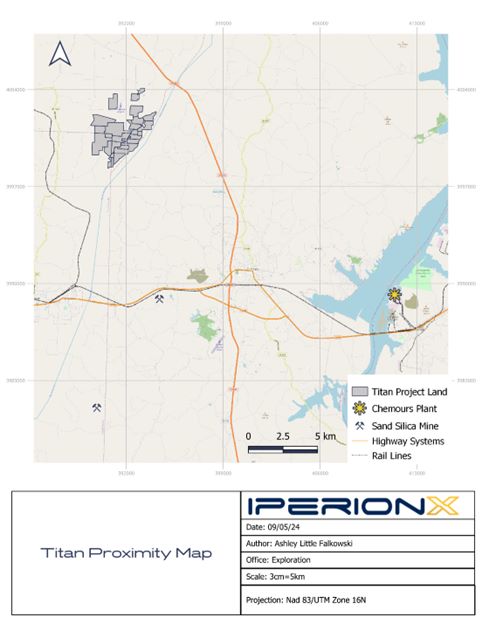
Figure 1: Titan project location
| 2.2 |
Terms of Reference
|
The Report was prepared to be attached as an exhibit to support mineral property disclosure, including mineral resource estimates, for the Titian Project for the year ending June 30, 2024.
Page 14 of 89
IPERIONX TITAN PROJECT, TENNESSEE – TECHNICAL REPORT SUMMARY
Mineral resources are reported for the Titan deposit using the definitions in Regulation S-K 1300 (S-K1300), under Item 1300.
All units of measurement used in this report use the International System of Units (SI) metric system unless otherwise stated. Mineral resources are reported in metric tonnes.
Currency is expressed in United States dollars (US$) as identified in the text.
The Report uses US English.
| 2.3 |
Qualified Persons
|
KGS is using the allowance for a third-party firm consisting of mining expert to date and sign the Report.
KGS had appropriate individual Qualified Persons (QPs) prepare the content that is summarized in this Report.
| 2.4 |
Qualified Person Site Visits and Laboratory Visits
|
KGS made several inspections of the site from October 2020 to June 2022 to review the drilling methods, sample collection, bulk sample collection, bulk processing and quality assurance and quality control (QAQC)
procedures, as shown in Table 3.
Table 3: KGS site and laboratory visits summary
|
Visit Start Date
|
Visit End Date
|
Location
|
Scope
|
||||
|
14-Oct-2020
|
16-Oct-2020
|
Mansfield, TN
|
Initial drilling support and procedure development
|
||||
|
24-Feb-2021
|
26-Feb-2021
|
Mansfield, TN
|
Phase 2 drilling support and procedures check
|
||||
|
5-Apr-2021
|
5-Apr-2021
|
Starke, FL
|
Oversight of metallurgical testing process
|
||||
|
19-Apr-2021
|
21-Apr-2021
|
Mansfield, TN
|
Drilling and sampling review, geochemistry and metallurgical review of results, Initial modelling
|
||||
|
15-Jun-2021
|
17-Jun-2021
|
Mansfield, TN
|
Bulk density testing, review of results, resource modelling
|
||||
|
17-Aug-2021
|
20-Aug-2021
|
Mansfield, TN
|
Drilling and sampling review, review of results
|
||||
|
1-Dec-2021
|
5-Dec-2021
|
Mansfield, TN
|
Drilling and sampling review and support
|
||||
|
21-Feb-2022
|
25-Feb-2022
|
Mansfield, TN
|
Drilling and sampling review and support
|
||||
|
2-May-2022
|
6-May-2022
|
Mansfield, TN
|
Drilling and sampling review and support
|
||||
|
26-Jun-2022
|
30-Jun-2022
|
Mansfield, TN
|
Drilling and sampling review and support
|
||||
|
24-Apr-2023
|
25-Apr-2023
|
Lakefield, Canada
|
Oversight of analytical procedures
|
KGS visited the Mineral Technologies laboratory in Florida on 5 April 2021 and was satisfied with the laboratory procedures as witnessed during that inspection.
KGS visited SGS Lakefield between 24–25 April 2023 and was satisfied with the laboratory procedures witnessed during that inspection.
| 2.5 |
Report Date
|
The Report is current as at June 30, 2024.
| 2.6 |
Information Sources and References
|
The reports and documents listed in Chapter 24 and Chapter 25 of this Report were used to support Report preparation.
Page 15 of 89
IPERIONX TITAN PROJECT, TENNESSEE – TECHNICAL REPORT SUMMARY
KGS has relied upon information provided by IperionX as identified in Chapter 25.
| 2.7 |
Previously Filed Technical Report Summaries
|
IperionX has previously filed a technical report summary on the Project: “Technical Report Summary for Titan Project”, “6-K (Current report) EX-99.2” filed on EDGAR on 1 July 2022.
Page 16 of 89
IPERIONX TITAN PROJECT, TENNESSEE – TECHNICAL REPORT SUMMARY
| 3 |
Property Description
|
| 3.1 |
Location
|
The Titan Project is located near Camden, Tennessee, US, approximately 128 km (80 miles) west of Nashville, Tennessee and approximately 11 km (7 miles) northwest of Camden, Tennessee.
The Project is centered at approximately 36.14734997015158N, -88.20974639890532W. The Project is located on the Mansfield, Manleyville, Vale and Bruceton United States Geological Survey Quadrangles.
| 3.2 |
Ownership
|
The Project is owned by IperionX Critical Minerals, LLC., a wholly-owned subsidiary of IperionX Limited.
| 3.3 |
Mineral Title
|
As of June 30, 2024, the Titan Project resource area comprised approximately 11.0 km2 (2,726 acres) of surface and associated mineral
rights in Tennessee, of which approximately 4.9 km2 (1,211) acres are owned by IperionX, approximately 1.0 km2 (242 acres) are subject to long-term lease by IperionX, and approximately 5.2 km2 (1,273 acres) are subject to exclusive option
agreements with IperionX. These exclusive option agreements, upon exercise, allow IperionX to the surface property and associated mineral rights. IperionX holds additional mineral tenures that are not considered currently to be part of the Titan
Project resource area under this TRS.
A Titan land list is provided as Table 4. The claim locations are shown in Figure 2.
Table 4: Titan land list
|
Land
Status
|
Acreage
|
Owner
|
Parcel #
|
Address
|
City
|
Zip code
|
County
|
Ownership
Interest
|
Grant Date
|
Expiry Date
|
|
Leased
|
31.3
|
Whistling Wings Farm LLC
|
009 023 00200 000
|
Pleasant Hill Rd
|
Hollow Rock
|
38342
|
Carroll
|
Surface, Mineral, Water
|
24-Oct-23
|
24-Oct-43
|
|
Leased
|
27.5
|
Whistling Wings Farm LLC
|
040 175 01301 000
|
W Sandy River
|
Mansfield
|
38236
|
Henry
|
Surface, Mineral, Water
|
24-Oct-23
|
24-Oct-43
|
|
Leased
|
183
|
Whistling Wings Farm LLC
|
040 171 01100 000
|
Little Benton Rd
|
Mansfield
|
38236
|
Henry
|
Surface, Mineral, Water
|
24-Oct-23
|
24-Oct-43
|
|
Optioned
|
100
|
Borchert Timothy W
|
040 171 01300 000
|
Little Benton Rd
|
Mansfield
|
38236
|
Henry
|
Surface, Mineral, Water
|
30-Oct-20
|
30-Oct-25
|
|
Optioned
|
145.9
|
Farmer Brent & Jessica Living Trust
|
040 168 01100 000
|
Little Benton Rd
|
Mansfield
|
38236
|
Henry
|
Surface, Mineral, Water
|
15-Jan-21
|
15-Jan-26
|
|
Optioned
|
34
|
Holcomb Richard Eugene
|
040 168 00502 000
|
565 Little Benton Rd
|
Mansfield
|
38236
|
Henry
|
Surface, Mineral, Water
|
15-Jan-21
|
15-Jan-26
|
|
Optioned
|
63.6
|
Holcomb Richard Joel Dwight
|
040 168 00501 000
|
Little Benton Rd
|
Mansfield
|
38236
|
Henry
|
Surface, Mineral, Water
|
15-Jan-21
|
15-Jan-26
|
|
Optioned
|
110
|
Patterson Gary N etux Karay L
|
040 171 00504 000
|
Little Benton Rd
|
Mansfield
|
38236
|
Henry
|
Surface, Mineral, Water
|
30-May-21
|
3-May-26
|
|
Optioned
|
97
|
Patterson Gary N& Patterson Lary D& Medema Rita M
|
040 171 00500 000
|
Little Benton Rd
|
Mansfield
|
38236
|
Henry
|
Surface, Mineral, Water
|
30-May-21
|
3-May-26
|
|
Optioned
|
22.3
|
Patterson Gary N& Patterson Lary D& Medema Rita M
|
040 171 00501 000
|
Little Benton Rd
|
Mansfield
|
38236
|
Henry
|
Surface, Mineral, Water
|
30-May-21
|
3-May-26
|
|
Optioned
|
88.2
|
Patterson Gary N& Patterson Lary D& Medema Rita M
|
040 168 01700 000
|
Little Benton Rd
|
Mansfield
|
38236
|
Henry
|
Surface, Mineral, Water
|
30-May-21
|
3-May-26
|
|
Optioned
|
84
|
Pettyjohn Steven
|
040 171 00800 000
|
Little Benton Rd
|
Mansfield
|
38236
|
Henry
|
Surface, Mineral, Water
|
30-Oct-20
|
30-Oct-25
|
|
Optioned
|
36
|
Sanders Timm
|
009 005 00201 000
|
Pleasant Hill Rd Nw
|
Hollow Rock
|
38342
|
Carroll
|
Surface, Mineral, Water
|
30-Nov-20
|
30-Nov-25
|
Page 17 of 89
IPERIONX TITAN PROJECT, TENNESSEE – TECHNICAL REPORT SUMMARY
|
Land
Status
|
Acreage
|
Owner
|
Parcel #
|
Address
|
City
|
Zip code
|
County
|
Ownership
Interest
|
Grant Date
|
Expiry
Date
|
|
Optioned
|
150
|
Sanders Timm
|
040 168 01300 000
|
Porter Norwood Rd
|
Mansfield
|
38236
|
Henry
|
Surface, Mineral, Water
|
30-Nov-20
|
30-Nov-25
|
|
Optioned
|
90.3
|
Sanders Timothy
|
040 168 01801 000
|
Little Benton Rd
|
Mansfield
|
38236
|
Henry
|
Surface, Mineral, Water
|
30-Nov-20
|
30-Nov-25
|
|
Optioned
|
102
|
Wilson Finas etux Sarah et al David Wilson et ux
|
009 005 00300 000
|
Pleasant Hill Rd
|
Hollow Rock
|
38342
|
Carroll
|
Surface, Mineral, Water
|
30-Nov-20
|
30-Nov-25
|
|
Optioned
|
104
|
Wilson Finas etux Sarah & David etux Cindy
|
040 171 01001 000
|
Little Benton Rd
|
Mansfield
|
38236
|
Henry
|
Surface, Mineral, Water
|
30-Nov-20
|
30-Nov-25
|
|
Optioned
|
45.5
|
Wilson Finas etux Sarah & Wilson David etux Cindy
|
040 171 01000 000
|
Little Benton Rd
|
Mansfield
|
38236
|
Henry
|
Surface, Mineral, Water
|
30-Nov-20
|
30-Nov-25
|
|
Owned
|
327.4
|
IperionX Critical Minerals LLC
|
009 005 00200 000
|
Pleasant Hill Rd
|
Hollow Rock
|
38342
|
Carroll
|
Surface, Mineral, Water
|
1-Sep-20
|
N/A
|
|
Owned
|
66.5
|
IperionX Critical Minerals LLC
|
040 171 00901 000
|
3105 Little Benton Rd
|
Mansfield
|
38236
|
Henry
|
Surface, Mineral, Water
|
1-Dec-20
|
N/A
|
|
Owned
|
3.9
|
IperionX Critical Minerals LLC
|
040 171 00903 000
|
3105 Little Benton Rd
|
Mansfield
|
38236
|
Henry
|
Surface, Mineral, Water
|
1-Dec-20
|
N/A
|
|
Owned
|
3.9
|
IperionX Critical Minerals LLC
|
040 171 00904 000
|
3105 Little Benton Rd
|
Mansfield
|
38236
|
Henry
|
Surface, Mineral, Water
|
1-Dec-20
|
N/A
|
|
Owned
|
308
|
IperionX Critical Minerals LLC
|
040 171 00300 000
|
County Line Rd
|
Mansfield
|
38236
|
Henry
|
Surface, Mineral, Water
|
1-Sep-20
|
N/A
|
|
Owned
|
35.2
|
IperionX Critical Minerals LLC
|
040 171 00503 000
|
Little Benton Rd
|
Mansfield
|
38236
|
Henry
|
Surface, Mineral, Water
|
1-Dec-20
|
N/A
|
|
Owned
|
100
|
IperionX Critical Minerals LLC
|
040 171 00200 001
|
County Line Rd
|
Mansfield
|
38236
|
Henry
|
Surface, Mineral, Water
|
1-Sep-20
|
N/A
|
|
Owned
|
229.7
|
IperionX Critical Minerals LLC
|
040 168 014.03 000
|
Bear Creek Rd
|
Mansfield
|
38320
|
Henry
|
Surface, Mineral, Water
|
15-May-21
|
N/A
|
|
Owned
|
137
|
IperionX Critical Minerals LLC
|
040 171 00900 000
|
Little Benton Rd
|
Mansfield
|
38236
|
Henry
|
Surface, Mineral, Water
|
10-Feb-21
|
N/A
|
Page 18 of 89
IPERIONX TITAN PROJECT, TENNESSEE – TECHNICAL REPORT SUMMARY
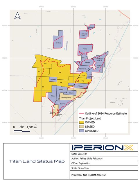
Figure 2: Titan land status map
IperionX’s option to lease agreements, upon exercise, allow IperionX to lease the surface property and associated mineral rights from the local landowners, and generally have expiry dates between mid-2026 to late
2027. During the option period, the option to lease agreements provide for annual option payments and bonus payments during periods when drilling is conducted. IperionX’s annual option payments are $75.00 per acre and the drilling bonuses
generally average approximately $1.00 per drill foot. IperionX’s obligation to make annual option payments and drilling bonus payments cease if the company exercises the option to lease.
| 3.4 |
Surface Rights and Water Rights
|
IperionX has acquired surface, subsurface and water rights to the properties within the resource area. Some of the properties have been acquired in fee simple by IperionX, with IperionX now being the sole owner of the surface, subsurface and
water rights for such properties. IperionX has entered into long-term ground leases for other properties, with the right to control the surface, subsurface and water rights related to those properties for the term of the respective ground leases.
For the rest of the properties, IperionX holds an option to lease such properties conditioned on annual option payments that are current and ongoing. The option agreements grant IperionX the right to evaluate the surface, subsurface and water
rights to such optioned properties.
Page 19 of 89
IPERIONX TITAN PROJECT, TENNESSEE – TECHNICAL REPORT SUMMARY
| 3.5 |
Royalties
|
Upon exercise, in the case of an option to lease, IperionX will pay an annual minimum royalty, generally $75 per acre, and a mining royalty, generally 5% of net revenues from products sold on all leased properties. All properties owned by
IperionX or its subsidiary (TN Exploration, LLC.) will not incur a royalty.
| 3.6 |
Encumbrances
|
There are no known encumbrances.
There are no current material violations and fines, as imposed in the mining regulatory context of the Mine Safety and Health Administration (MSHA) in the US that apply to the Titan Project.
| 3.7 |
Environmental Studies
|
| 3.7.1 |
Critical Issues Analysis
|
In 2020, HDR Engineering, Inc. (HDR) conducted a desktop review of topographic and aerial photograph base maps for the Project area using publicly available geographic information system (GIS) and interactive
web-based mapping applications. HDR used available data for Benton, Carroll and Henry Counties to assess potential environmental conditions.
Following mapping and the initial environmental assessment, HDR completed a regulatory review and permit evaluation of the proposed project as it relates to the following federal, state, and local environmental
regulations.
| 3.7.2 |
United States Army Corps of Engineers Wetland Delineation and Tennessee Department of Environment and Conservation Hydrologic Determination Field Work
|
In 2021, HDR conducted a stream/wetland delineation, threatened and endangered species habitat survey, cultural resources review, and continue to support a groundwater quality and quantity testing program.
HDR conducted field visits in May and June 2021 to document United States Army Corps of Engineers (USACE)-regulated jurisdictional Waters of the US and Tennessee Department of Environment and Conservation
(TDEC)-regulated waters of the state within the site.
| 3.7.3 |
Federally and State Threatened and Endangered Habitat Survey
|
HDR identified federal and state listed species habitat likely to occur on or in the vicinity of the site. HDR requested an Environmental Review through the TDEC Natural Heritage Program (NHP) which provided
site-specific data of known state and federal concern plant and animal species, ecologically significant sites, and certain conservation managed lands. HDR conducted a pedestrian survey of the site to verify the presence or absence of potential
habitat for federally threatened and endangered species that may occur on the site.
A brief memorandum to IperionX was prepared detailing the results of the federal and state threatened and endangered species habitat survey results. The memorandum was delivered to IperionX on 1 July 2021.
| 3.7.4 |
Cultural Resources Background Research
|
HDR conducted a National Historic Preservation Act (NHPA) cultural resources background investigation for the approximately 2,432-acre portion of the Titan Project located in Carroll and Henry Counties in April
2021. The purpose of the investigation was to identify known historic (National Register of Historic Places (NRHP)-eligible) properties in the Project Area and surrounding one-mile radius and make recommendations on further NHPA cultural
resources work for the Project.
Page 20 of 89
IPERIONX TITAN PROJECT, TENNESSEE – TECHNICAL REPORT SUMMARY
The research included results from the Tennessee Division of Archaeology (TDOA), the Tennessee Historical Commission (THC), the NRHP GIS database, and the Tennessee Cemetery Database (TNGenWeb). HDR synthesized the
research results and issued a report summarizing the findings of the background investigation completed for the Titan Project and associated recommendations that was delivered to IperionX on 30 June 2021.
HDR identified six previously recorded archaeological sites and five cemeteries within one mile of the Project area. None of these sites are located within the Project area.
| 3.7.5 |
Baseline Groundwater and Surface Water Study
|
Baseline groundwater and surface water assessment data collection was completed in 2021 by HDR. This included installation of monitoring and aquifer test wells, together with a 72-hr aquifer pumping test conducted
in June 2021. HDR completed six bi-monthly groundwater and surface water monitoring tests from June 2021 to April 2022.
| 3.7.6 |
Partnership with University of Tennessee’s Institute of Agriculture
|
IperionX is partnering with the University of Tennessee Institute of Agriculture (UTIA) to research the implementation of sustainable operating and rehabilitation practices at the Titan Project in West Tennessee. The
University of Tennessee is the flagship university in the state of Tennessee, and UTIA is at the forefront of agribusiness research, education and community outreach.
The Titan Project will include programs focused on post mineral extraction practices and carbon sequestration opportunities for generational land-use benefits for local landowners. The initial scope of work will
focus upon the elimination of invasive vegetation and subsequent improved ecological revegetation using native warm season grasses, undertaken on IperionX’s owned properties.
IperionX and UTIA with aid from county University of Tennessee (UT) extension offices, has established a seven acre native site at the Titan Project for UTIA’s use for the initial scope of work, with the potential
for the site to be used for additional sustainability investigations, including the use of biochars, gypsum and other soil amendments to aid in higher crop yields and the carbon sequestration.
IperionX and UTIA are also in the process of preparing an additional three-acre lot that will be used to grow a mixture of native grass and pollinator plants to assist with the biodiverse efforts of habitat
restoration in the area.
| 3.8 |
Permitting
|
TDEC granted IperionX the required state Surface Mining Permit (OM-70711-01) and National Pollutant Discharge Elimination System Permit (TN0070711) on 14 August 2023. TN Surface Mining Permit is a five-year permit and will need to be renewed and
updated every five years. The first renewal will be required by 14 August 2028.
TDEC also determined that IperionX’s proposed sand processing operations would constitute an insignificant activity or insignificant emissions unit, as defined in part 1200-03-09-.04(2)(a)3. of the Tennessee Air Pollution Control Regulations.
TDEC has confirmed that all regulatory permit requirements for the Titan Project phase 1 have been met by IperionX.
| 3.9 |
Community Relations
|
IperionX has actively engaged with TDEC, Tennessee Valley Authority (TVA), TN state government officials, community members, business owners, local government officials, local school systems, universities, technical schools, local and state
government groups. IperionX will continue identifying and engaging with new groups and stakeholders.
Page 21 of 89
IPERIONX TITAN PROJECT, TENNESSEE – TECHNICAL REPORT SUMMARY
IperionX advised KGS that the company’s vision is to create a legacy of operational excellence by maintaining positive and sustainable industry standards, credible communications, and shared beneficial opportunities, including a focus on local
employment. IperionX advised that it plans to continue to operate with a transparent and open-door standard. IperionX has sponsored local recreation teams, provided scholarships and given seminars at local schools and universities.
Table 5 provides a summary of the community relations activities completed at the Report date.
Table 5: Community relations activities list
|
Date
|
Organization
|
Community Relations Activity
|
|||
|
20-Jan-2021
|
Benton County officials
|
First introduction to IperionX
|
|||
|
29-Jan-2021
|
WRJB radio
|
Interview
|
|||
|
15-Feb-2021
|
Benton County Commission
|
Meeting with County Commission
|
|||
|
10-Mar-2021
|
Carroll County officials
|
Meeting with Carroll County officials
|
|||
|
11-Mar-2021
|
Henry County officials
|
Meeting with Henry County officials
|
|||
|
17-Mar-2021
|
Community
|
IperionX office grand opening
|
|||
|
28-Mar-2021
|
Veterans Honor Guard
|
Donation
|
|||
|
20-Apr-2021
|
Benton County school officials
|
Meeting with school officials
|
|||
|
25-May-2021
|
Benton County officials
|
Meeting with Benton County officials
|
|||
|
8-Jun-2021
|
West TN Bass Tournament
|
IperionX information booth/sponsor
|
|||
|
1-Jul-2021
|
Governors
|
Meeting with TN government
|
|||
|
20-Jul-2021
|
PGS
|
Community Forum hosted by PGS
|
|||
|
1-Aug-2021
|
TN Achieves Mentor Program
|
Volunteer
|
|||
|
4-Aug-2021
|
TN Governors Conference
|
Attendance at the TN Governors Conference
|
|||
|
18-Aug-2021
|
Benton County High School Academic Banquet
|
Attendance
|
|||
|
24-Aug-2021
|
Benton County Fair
|
IperionX Information booth/lawnmower race sponsor
|
|||
|
1-Sep-2021
|
University of Knoxville
|
Meeting with President Randy Boyd
|
|||
|
12-Oct-2021
|
University of Knoxville
|
Meeting with UTK Professors
|
|||
|
28-Oct-2021
|
First Responders Dinner
|
Hosted dinner
|
|||
|
31-Oct-2021
|
IperionX Halloween
|
IperionX Halloween event
|
|||
|
5-Dec-2021
|
University of Knoxville
|
Visited the UTK campus and dinner
|
|||
|
10-Dec-2021
|
TN Chamber/Manufactures and Industry roundtable
|
Attended the round table
|
|||
|
18-Dec-2021
|
Senior Citizens home
|
Adopt a Senior
|
|||
|
20-Dec-2021
|
Benton County Christmas parade
|
IperionX truck in parade
|
|||
|
5-Feb-2022
|
District Director Sam Neinow at Congressman Mark Green
|
Sam Neinow brief for Congressman Green
|
|||
|
10-Feb-2022
|
Congressman Green
|
Meeting with Congressman Green
|
|||
|
5-Feb-2022
|
Agricultural Commission Board
|
IperionX CEO addressed Agricultural Commission Board members
|
|||
|
8-Mar-2022
|
Carroll County government
|
Attendance at Carroll County government meeting
|
Page 22 of 89
IPERIONX TITAN PROJECT, TENNESSEE – TECHNICAL REPORT SUMMARY
|
Date
|
Organization
|
Community Relations Activity
|
|||
|
14-Mar-2022
|
Carroll County Prodigy softball
|
Donation for softball team
|
|||
|
28-Mar-2022
|
Benton County teacher inservice
|
Presentation
|
|||
|
6-Apr-2022
|
Benton County public Q&A session
|
Information and update
|
|||
|
10-Apr-2022
|
Henry County fish fry
|
IperionX tent demonstration
|
|||
|
16-Apr-2022
|
Fishing rodeo
|
Attendance and donation
|
|||
|
24-Apr-2022
|
Scotts Hill career day
|
Presentation
|
|||
|
10-May-2022
|
Carroll County golf tournament
|
IperionX tent/sponsorship
|
|||
|
1-Jun-2022
|
Forever Communications
|
Interview with Henry County radio
|
|||
|
6-Jun-2022
|
Carroll County schools
|
Academic sponsorship
|
|||
|
12-Jun-2022
|
Get Loaded Tea
|
IperionX promotion and sponsorship
|
|||
|
18-Jun-2022
|
Senator Hagerty/Benton County Mayor
|
Meeting with Senator Hagerty/Benton County Mayor
|
|||
|
20-Jun-2022
|
Benton County STEM camp
|
STEM camp presentation
|
|||
|
22-Jun-2022
|
Henry County Carl Perkins Center for Child Abuse
|
Table sponsorship
|
|||
|
26-Jun-2022
|
Magic Valley Golf/Buccaneers
|
Attended and sponsored the Pro Golf tournament
|
|||
|
29-Jun-2022
|
Benton County Drug Prevention/UT Ag
|
Children Yoga sponsorship
|
|||
|
3-Jul-2022
|
Birdsong Resort & Marina
|
4th of July attendance/sponsorship
|
|||
|
7-Jul-2022
|
Tennessee Department of Economic and Community Development
|
Meeting with several groups
|
|||
|
12-Jul-2022
|
University of Tennessee at Martin
|
Campus tour
|
|||
|
15-Jul-2022
|
UT Martin Director
|
IperionX information discussion
|
|||
|
18-Jul-2022
|
Henry County Mike Weatherford show
|
IperionX interview
|
|||
|
20-Jul-2022
|
West TN football/cheer
|
Sponsorship
|
|||
|
24-Jul-2022
|
County officials
|
Meeting with several groups
|
|||
|
30-Jul-2022
|
Benton County Drug Prevention Coalition
|
Attendance at the Red Sand event
|
|||
|
4-Aug-2022
|
UT Extension
|
Donation for new agriculture silos
|
|||
|
9-Aug-2022
|
District Director Sam Neinow at Congressman Mark Green /Benton County Mayor
|
Meeting with Sam Neinow/Benton County Mayor
|
|||
|
13-Aug-2022
|
Henry County Terra Recycling event
|
Sponsored an electronics recycling drive in Henry County
|
|||
|
15-Aug-2022
|
Benton County Fair Salute to First Responders
|
Attendance
|
|||
|
22-Aug-2022
|
Henry County Fair
|
Attendance and IperionX booth/demonstration
|
|||
|
26-Aug-2022
|
Benton County Fair
|
Attendance and IperionX booth/demonstration
|
|||
|
27-Aug-2022
|
STEAM Garden
|
Donated to the new STEAM Garden
|
|||
|
4-Sep-2022
|
Mckenzie sweet tea festival
|
IperionX tent demonstration
|
|||
|
9-Sep-2022
|
Forever Communications
|
IperionX CEO interview
|
|||
|
9-Sep-2022
|
Native American Indian Association of Tennessee
|
Donation
|
|||
|
10-Sep-2022
|
One Community One Heart
|
Benton County Volunteer Day event
|
|||
|
11-Sep-2022
|
911 Memorial Walk
|
IperionX Attendance
|
|||
|
12-Sep-2022
|
Benton County Prevention Coalition
|
Attended /hosted luncheon
|
Page 23 of 89
IPERIONX TITAN PROJECT, TENNESSEE – TECHNICAL REPORT SUMMARY
|
Date
|
Organization
|
Community Relations Activity
|
|||
|
20-Sep-2022
|
Camden Masonic Lodge
|
Donation for food plates
|
|||
|
20-Sep-2022
|
West TN Veterans bike ride
|
Donation
|
|||
|
21-Sep-2022
|
IperionX Media Day at Demo Site
|
IperionX information update to several groups
|
|||
|
15-Oct-2022
|
West TN Saddle Club
|
Sponsorship
|
|||
|
16-Oct-2022
|
Native American Indian Association of Tennessee
|
Pow Wow sponsorship
|
|||
|
27-Oct-2022
|
Carroll County Boo Bash
|
Halloween Trunk or Treat
|
|||
|
29-Oct-2022
|
Henry County Spooktacular
|
Halloween Trunk or Treat
|
|||
|
31-Oct-2022
|
Benton County IperionX Halloween Bash
|
Annual office Halloween event
|
|||
|
2-Nov-2022
|
University of Tennessee at Martin
|
Geo Sciences Club meeting attendance
|
|||
|
8-Nov-2022
|
All American Cheer
|
Purchased coupon book
|
|||
|
9-Nov-2022
|
Henry County Noon on the square
|
Attendance
|
|||
|
11-Nov-2022
|
American Legion Veterans
|
Volunteer
|
|||
|
2-Dec-2022
|
Henry County Shop with a Cop
|
Donation
|
|||
|
5-Dec-2022
|
Benton County Manufactures Day
|
Presentation
|
|||
|
15-Dec-2022
|
Carroll County Toys for Tots
|
Toy donation
|
|||
|
15-Dec-2022
|
Benton County Toys for Tots
|
Toy donation
|
|||
|
18-Dec-2022
|
Henry County Christmas parade
|
IperionX truck in parade
|
|||
|
18-Dec-2022
|
St Vincent DePaul
|
Donation for flood victims
|
|||
|
1-Jan-2023
|
TN Acheives Mentor Meeting
|
Meeting at Bethel University
|
|||
|
14-Jan-2023
|
Beta Club
|
5-kilometer run
|
|||
|
25-Jan-2023
|
Benton County School Board
|
Attendance
|
|||
|
30-Jan-2023
|
Carroll County Career & Technical Ed
|
Attendance/IperionX discussion
|
|||
|
31-Jan-2023
|
American Legion Girls State
|
Scholarship donation
|
|||
|
1-Feb-2023
|
Big Sandy Q&A
|
Community Q&A
|
|||
|
8-Feb-2023
|
Carroll County Chamber Coffee
|
Attendance/networking
|
|||
|
16-Feb-2023
|
Carroll County Q&A
|
Community Q&A
|
|||
|
17-Feb-2023
|
Henry County Q&A
|
Community Q&A
|
|||
|
18-Feb-2023
|
American Legion Veterans
|
Chili dinner
|
|||
|
6-Mar-2023
|
Benton County Animal Shelter
|
Sponsorship of a dog adoption fee
|
|||
|
6-Mar-2023
|
Benton County Garden Club
|
IperionX attendance and presentation
|
|||
|
9-Mar-2023
|
IperionX Children’s Book Launch
|
Introduction of the children’s book in Henry County
|
|||
|
25-Mar-2023
|
Henry County Elementary
|
Book reading/presentation
|
|||
|
25-Mar-2023
|
Carroll County Elementary
|
Book reading/presentation
|
|||
|
28-Mar-2023
|
Benton County Elementary
|
Book reading/presentation
|
|||
|
30-Mar-2023
|
Henry County Library
|
Book presentation/donation
|
|||
|
30-Mar-2023
|
Carroll County Library
|
Book presentation/donation
|
|||
|
14-Apr-2023
|
Scotts Hill High School
|
Career Day presentation
|
|||
|
26-Apr-2023
|
Henry County High School
|
Project Graduation donation
|
|||
|
26-Apr-2023
|
Benton County High School
|
Project Graduation donation
|
|||
|
26-Apr-2023
|
Carroll County High School
|
Project Graduation donation
|
Page 24 of 89
IPERIONX TITAN PROJECT, TENNESSEE – TECHNICAL REPORT SUMMARY
|
Date
|
Organization
|
Community Relations Activity
|
|||
|
28-Apr-2023
|
Henry County fish fry
|
Attendance/networking
|
|||
|
15-May-2023
|
West TN Boy Scouts
|
Tour of Boy Scouts of America Camp
|
|||
|
30-May-2023
|
Native American Indian Association
|
Scholarship donation
|
|||
|
10-Jun-2023
|
TN Kids fishing rodeo
|
Awards sponsorship
|
|||
|
11-Jun-2023
|
TN Mining Association
|
Conference sponsorship
|
|||
|
28-Jun-2023
|
Camden Elementary School
|
STEM summer camp presentation/donation
|
|||
|
9-Jul-2023
|
Native American Indian Association of Tennessee
|
Pow Wow sponsorship
|
|||
|
20-Jul-2023
|
West TN STEM Scholarship
|
Scholarship donation
|
|||
|
2-Sep-2023
|
WRAP Jam
|
IperionX Tent
|
|||
|
6-Sep-2023
|
West TN Public Utility
|
Luncheon attendance/networking
|
|||
|
7-Sep-2023
|
Camden Elementary School
|
Outdoor Garden Open House
|
|||
|
29-Sep-2023
|
Camden Masonic Lodge
|
Dinner attendance
|
|||
|
19-Oct-2023
|
Carroll County Career & Technical Ed
|
Meeting attendance/discussion
|
|||
|
19-Oct-2023
|
United Way Radio Auction
|
Guest Auctioneer/donation
|
|||
|
20-Oct-2023
|
TMA Conference in Gatlinburg
|
Attendance/sponsorship
|
|||
|
21-Oct-2023
|
Native American Indian Association of Tennessee
|
Attendance at the Pow Wow
|
|||
|
25-Oct-2023
|
Carroll County Career Fair
|
Attendance IperionX tent booth
|
|||
|
28-Oct-2023
|
Henry County Trunk or Treat
|
Handed out candy
|
|||
|
29-Oct-2023
|
Elementary schools
|
Delivered Halloween coloring pages/safety checklist
|
|||
|
31-Oct-2023
|
IperionX Halloween event
|
Annual office Halloween event
|
|||
|
9-Nov-2023
|
Darkhorse Veterans Lodge
|
Volunteer
|
|||
|
17-Nov-2023
|
Carroll County Veterans Art Exhibit
|
Volunteer
|
|||
|
5-Dec-2023
|
Mckenzie Rotary Club
|
IperionX Presentation
|
|||
|
5-Dec-2023
|
Mckenzie Industrial Board
|
Toured Mckenzie Industrial Site Commercial Facility
|
|||
|
12-Dec-2023
|
Carroll County Toys for Tots
|
Donation
|
|||
|
12-Dec-2023
|
Henry County Toys for Tots
|
Donation
|
|||
|
13-Dec-2023
|
IperionX holiday cards
|
100 cards mailed to key county personnel and all IperionX Landowners
|
|||
|
14-Dec-2023
|
Benton County Senior Citizen Holiday
|
Holiday Basket donation to senior citizen
|
|||
|
3-Jan-2024
|
Senator Marsha Blackburn Meeting
|
Drop-in meeting held at Second Harvest Food Bank
|
|||
|
12-Jan-2024
|
Henry County Helping Hands
|
Donation to Pleasant Hill community
|
|||
|
25-Jan-2024
|
Northwest Economic Development Food Boxing
|
Volunteer
|
|||
|
14-Feb-2024
|
Tennessee Mining Association
|
Joined TMA on Capitol Hill in Nashville
|
|||
|
12-Mar-2024
|
TN Achieves Lunch and Tennessee Colleges of Applied Technology
|
Mentor lunch and TCAT tech school tour
|
|||
|
19-Mar-2024
|
Forever Communications
|
Visit in Henry County
|
|||
|
19-Mar-2024
|
Henry County Real Hope Youth Center
|
Visit in Henry County
|
|||
|
20-Mar-2024
|
Carroll County Career Day
|
IperionX tent/demonstration for career day
|
|||
|
26-Mar-2024
|
Benton County Volunteer Program
|
Presentation/IperionX Information
|
Page 25 of 89
IPERIONX TITAN PROJECT, TENNESSEE – TECHNICAL REPORT SUMMARY
|
Date
|
Organization
|
Community Relations Activity
|
|||
|
27-Apr-2024
|
Henry County fish fry
|
Attendance/networking
|
|||
|
27-Apr-2024
|
Darkhorse Veterans Lodge
|
Donation
|
|||
|
28-Apr-2024
|
Tennessee Mining Association
|
Conference sponsorship
|
|||
|
2-May-2024
|
Scotts Hill Career Day
|
Presentation/IperionX Information
|
|||
|
4-May-2024
|
Benton County Drug Prevention Awareness Day
|
IperionX tent
|
|||
|
18-Jun-2024
|
TN Health Connect
|
Overdose prevention training
|
|||
|
20-Jun-2024
|
2024 Scholarship Presentation
|
Scholarship
|
|||
|
25-Jun-2024
|
Tennessee College of Applied Technology
|
Groundbreaking ceremony
|
| 3.10 |
Significant Factors and Risks That May Affect Access, Title or Work Programs
|
To the extent known to KGS, there are no other significant factors and risks that may affect access, title, or the right or ability to perform work on the Project that are not discussed in this Report.
Page 26 of 89
IPERIONX TITAN PROJECT, TENNESSEE – TECHNICAL REPORT SUMMARY
| 4 |
Accessibility, Climate, Local Resources, Infrastructure and Physiography
|
| 4.1 |
Accessibility
|
General access to the Project is via a well-developed network of primary and secondary roads. The Project site can be accessed via highway 641 north 41.0 km from Interstate 40 near the town of Camden, TN,
Reynoldsburg Rd for 1.6 km, Pleasant Hill Rd for 1.6 km and the Little Benton Rd, a gravel road, for 4.8 km. Little Benton Rd goes through the Project site.
US Interstate I-80 is 35.4 km to the south of the Project. Tennessee overall has approximately 153,000 km of highway, including eight interstate highways, which can provide ready access to a majority of the US
consumer markets.
Tennessee is the third-largest rail center in the US. The CSX Transportation Memphis subdivision mainline runs through Camden (~ 4.8 km south of the Titan Project). The KWT Rail line connects to this mainline ~2.4
km east of the Titan Project).
There are more than 1,600 km of navigable waterways in Tennessee, which access all other major waterways in the eastern US. A major barge-loading point is located 24 km from the Titan Project.
There are four commercial airports near Camden, including two international airports at Memphis (approximately 217 km to the southwest) and Nashville (approximately 137 km to the east).
The Project location in relation to key local infrastructure was shown in Figure 1.
| 4.2 |
Climate and Length of Operating Season
|
The climate is temperate with warm summers and cold winters including the potential for snow/ice. Annual rainfall for the area is 136.6 cm.
Any future mining operation could operate year-round.
| 4.3 |
Local Resources and Infrastructure
|
The Project area is located near the towns of Camden and Paris, Tennessee.
The existing infrastructure includes power and gas, with 161 kV transmission lines near the Project area. IperionX intends to implement fully-renewable power sourcing options for the Titan Project, including the
assessment of existing on-grid solutions currently provided by existing power generators and suppliers in the general Project area. Additional communications will be required with the Tennessee Valley Authority, local power supplier, and gas
suppliers.
Water supply could be sourced from nearby surface water bodies or from shallow groundwater sources.
Personnel are assumed to live in surrounding communities. No accommodations camp would be required. Local active sand mining, gravel mining and timber operations could be sources of recruiting experienced operators.
| 4.4 |
Topography, Elevation and Vegetation
|
The Project area is located in the eastern portion of the United States and contains gently rolling topography with drainages (wetlands) dissecting the Project area.
Surface elevations at the Project range from approximately 175 m above sea level in the upland regions and approximately 100 m at the stream level.
The area exhibits a mix of hardwood forest, conifer forest and agricultural fields.
Page 27 of 89
IPERIONX TITAN PROJECT, TENNESSEE – TECHNICAL REPORT SUMMARY
| 5 |
History
|
No previous heavy mineral sand mining has occurred in the region.
The general Project area has been explored for heavy mineral sands since the 1950s as the McNairy Formation was known to contain high concentrations of heavy minerals based on work by federal and state agencies.
DuPont de Nemours, Inc., Kerr-McGee Corporation, RGC Mineral Sands Inc., Iluka Resources Inc, Altair International Inc., and Astron Corporation limited are known to have evaluated the McNairy Formation-hosted
deposits in the Project area at various times.
Page 28 of 89
IPERIONX TITAN PROJECT, TENNESSEE – TECHNICAL REPORT SUMMARY
| 6 |
Geological Setting, Mineralization, and Deposit
|
| 6.1 |
Deposit Model
|
An exploration program that uses the “Heavy Mineral Sands in Coastal Environments” model is considered acceptable for exploration purposes in the Project area.
Heavy mineral sands are created through physical and mechanical concentration of detrital minerals liberated through weathering. This weathering portion of this process occurs inland, while the deposition of these minerals ultimately occurs
along coastlines through features such as deltas, foreshore, shoreface, barrier islands, dunes and tidal lagoons. IperionX have observed all these features locally, within a deltaic infill environment.
| 6.2 |
Regional Geology
|
The Project’s location in western Tennessee represents the eastern flank of the Mississippi Embayment, a large, southward-plunging syncline within the Gulf Coastal Plain indicated in Figure 3.
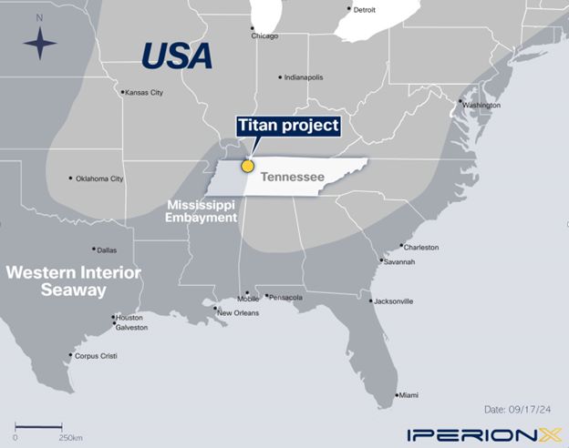
Figure 3: Mississippi Embayment & Cretaceous coastline
Page 29 of 89
IPERIONX TITAN PROJECT, TENNESSEE – TECHNICAL REPORT SUMMARY
This feature extends from southern Illinois to the north and to Mississippi and Alabama to the south. The embayment is filled with sediments and sedimentary rocks of Cretaceous to Quaternary age. Figure 4 shows
regional geology map encompassing Titan Project.
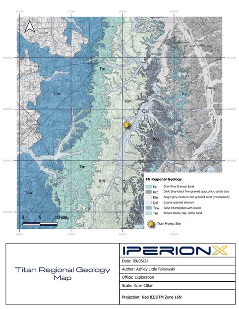
Figure 4: Regional geology map encompassing Titan Project
Page 30 of 89
IPERIONX TITAN PROJECT, TENNESSEE – TECHNICAL REPORT SUMMARY
| 6.3 |
Local Geology
|
The McNairy Formation represents a pro-grading deltaic environment during a regressive marine sequence. This is evidenced by the coarsening upward sequence grading from the glauconitic clay-rich Coon Creek Formation
to the finer grained lower member of the McNairy Formation to the coarser grained upper member of the McNairy Formation. Figure 5 is a simplified stratigraphic column through the McNairy Formation.
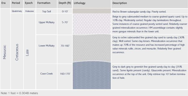
Figure 5: Idealized stratigraphic column through the McNairy sand
| 6.4 |
Project Geology
|
The primary mineralized zone at the Project is hosted stratigraphically in the lower member of the McNairy Formation, which dips gently to the west in the Project area. The upper member is also mineralized in some
areas at the Project and is at times separated from the lower zone by a barren coarse sand. Mineralization in both members had been traced at the Report date, for 6.2 km along strike.
The base of mineralization ranges in relative level from 90–110 m above current sea level. Mineralization varies from 6–51 m thick and averages 31 m in thickness and is generally made up of large thicknesses of stacked laminations of HMs;
however, some more massive mineralization is present where individual laminations are not present. The primary minerals associated with the mineralized horizons are altered ilmenite, zircon, rutile, staurolite, kyanite, monazite and xenotime with
some variation in the proportion of these minerals between the upper and lower zones. Generally, the finer-grained lower zone contains more higher-value HMs including rutile, zircon, monazite, and xenotime than the upper coarser-grained zone. The
gangue minerals are predominantly quartz and clays. Though extensive basement faulting is present in the region, it does not appear to impact the sedimentary stratigraphy at the scale of this project. Figure 6 presents the an example cross section.
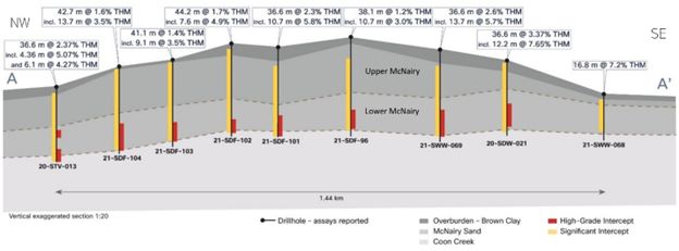
Figure 6: Example Titan drill results cross section in relation to stratigraphy, looking northeast
Page 31 of 89
IPERIONX TITAN PROJECT, TENNESSEE – TECHNICAL REPORT SUMMARY
| 7 |
Exploration
|
| 7.1 |
Exploration
|
| 7.1.1 |
Grids and Surveys
|
The coordinate system and datum used for mineral resource modeling is UTMZ16N, NAD83.
A topographic surface was generated from the state of Tennessee’s TN LiDAR program.
| 7.1.2 |
Exploration Sampling
|
IperionX has completed no geological mapping, geochemical sampling, or geophysical surveys in the Project area. All exploration is conducted using drill methods.
| 7.2 |
Drilling
|
| 7.2.1 |
Overview
|
Drilling on the Project area comprises 162 drill holes, this includes 16 reverse circulation holes (837 m) and 146 roto-sonic drill holes (7,338 m).
All drilling was completed by IperionX.
There are an additional 11 roto-sonic drill holes completed for the purposes as part of a hydrogeological study by HDR. These holes were drilled on IperionX’s behalf and not used for resource definition purposes.
| 7.2.2 |
Drilling Used in Mineral Resource Estimate
|
The mineral resource database was closed as at 4 August 2021, and included 107 roto-sonic drill holes (4,101 m).
The area covered by the drilling is roughly 6.2 km (north) by 3.6 km (east); the area that hosts the mineral resource estimate is further broken up into several areas based on land holdings (land
agreements). These range from 0.5 km (north) by 0.9 km (east) for the smallest area to 5.1 km (north) by 3.6 km (east) for the largest area (refer to Figure 2).
Drill hole spacing is generally 150 x 300 m. Some areas had difficult access and drill spacing in those areas is wider spaced, approximately up to 300 x 600 m.
Page 32 of 89
IPERIONX TITAN PROJECT, TENNESSEE – TECHNICAL REPORT SUMMARY
Figure 7 shows the drill hole collar location map. Drill hole cross section and long section view are provided in Figure 8 & 9.
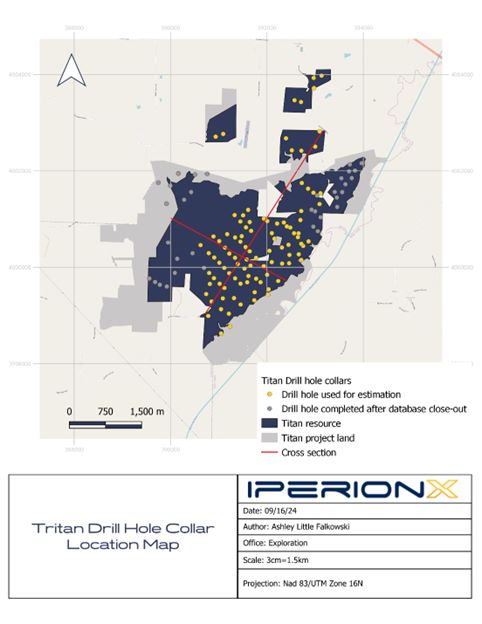
Figure 7: Drill hole collar location map
Page 33 of 89
IPERIONX TITAN PROJECT, TENNESSEE – TECHNICAL REPORT SUMMARY
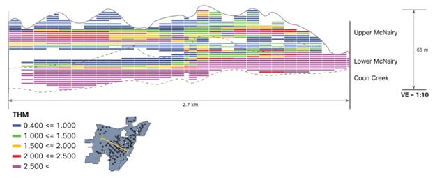
Figure 8: Block model cross section view, looking north
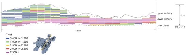
Figure 9: Block model long section view, looking west
| 7.2.3 |
Drilling Excluded For Estimation Purposes
|
A total of 66 drill holes were excluded from the mineral resource estimation. This included 39 roto-sonic exploration holes that the results were received after the database cut-off date, 11 holes that were drilled
in association with a hydrogeological study, and 16 reverse circulation drill holes because of the high likelihood of down hole sample contaminations.
Page 34 of 89
IPERIONX TITAN PROJECT, TENNESSEE – TECHNICAL REPORT SUMMARY
| 7.2.4 |
Metallurgical Drilling
|
The location of bulk samples taken for metallurgical test work is indicated in Figure 10. These samples were taken via a roto sonic drill rig drilling twin holes to previously analyzed holes.
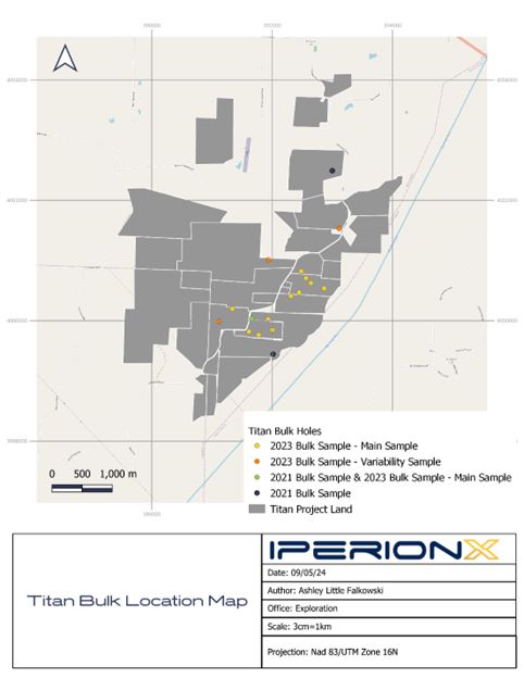
Figure 10: Bulk sample location map
| 7.2.5 |
Drill Methods
|
Drill companies included Knoxville, TN; Drillwise USA of Holladay, TN; and Betts Drilling of Atlanta, GA.
Drill rigs included a Geoprobe 5140LS roto-sonic drill rig (Geoprobe) a Terrasonic 150c rig (Terrasonic), and a Wallis RC rig. The Geoprobe core barrel was 3 m long, and 10 cm in diameter with a 15-cm diameter outer
casing. The Terrasonic core barrel was 3 m long and had a 10-cm diameter core barrel. Drill casing was used periodically when re-entering drill holes that had caved. Select drill holes were re-drilled and re-analyzed as part of data validation.
All drilling for the Project that is used in mineral resource estimation has been roto sonic. This method alternates advancement of a core barrel and a removeable casing (casing is used when needed to maintain
sample integrity). The sonic drilling method has been shown to provide representative unconsolidated mineral sands samples across a variety of deposits as it is a direct sampling method of the formation(s). At times water is used to create a
head to reduce the expansion of the clay-rich Coon Creek Formation sediments. Expansion of the Coon Creek Formation lithologies by up to 0.9 m length in the core barrel has been observed.
Page 35 of 89
IPERIONX TITAN PROJECT, TENNESSEE – TECHNICAL REPORT SUMMARY
In the field procedures included coring 3 m sections of material at a time with a roto-sonic drill rig. Drill teams set up on the proposed drill site with all holes drilled at a 90-degree angle, which is essentially perpendicular to
mineralization. Generally, holes are drilled without the use of water and typically without the use of casing. After each 3 m section was extracted, drill teams recovered the core in equal length plastic sleeves. Geologists then divided the core
into two 1.5 m sections that were analyzed for lithologic significance and heavy mineral potential.
After termination, holes were backfilled, and global positioning system coordinates were taken once the rig was moved from the hole. Field notes were recorded in the database.
At times water was used during drilling to create a head on the formation by lubricating the hole. This assisted in allowing core to be brought to the surface. However, it can inadvertently also create a more homogenized core, which may not
reflect the subsurface.
| 7.2.6 |
Logging
|
Logging was both qualitative (sorting, color, lithology) and quantitative (estimation of percent total heavy minerals and the percent slimes (% THM, %Slimes). Once the core was divided into 1.5 m sections, samples
were photographed and logged for lithological, geological, and mineralogical parameters to help determine depositional environment, major geological units, and mineralized zones. These parameters included lithology, grain-size, roundedness,
sorting, color, formation, and heavy mineral percent (HM%).
Analysis included panning for heavy mineral percentages using samples collected down the center of each 1.5 m section and molded into spheres approximately 4 cm in diameter.
After categorization, two 2 kg samples were taken down the center of each section, mimicking the panning sample. One sample was kept for IperionX records, and one was used for laboratory tests including heavy liquid
separation.
Quality check samples were taken 2% of the time and duplicates were taken 3% of the time. Holes terminated 3 m into the Coon Creek Formation, which was identified by its dark grey color and sticky clay texture. Total
depth of the drill hole was recorded, as well as any drilling issues/concerns that could impact sample representativeness.
All pertinent sample information (geology, sample ID, etc.) was collected on sequentially numbered tag books provided by the laboratory. The tag was inserted into the sample bag and the information from the tag book
was entered nightly into the Project database (GeoSpark). A chip tray was maintained for each hole to keep a representative sample for each interval for later use during geological interpretation, or if any questions arose during modelling.
Heavy mineral estimations can be impacted by several factors in the field, so it was important to implement procedures that addressed this possible occurrence. High-grade bands within a section can significantly
increase overall HM%. This is averted by taking an equal distribution of a panning sample in a line down the middle of a core section.
High clay content can affect the portrayal of heavy minerals in the pan. This is caused by pieces of unprocessed clay fragments that can contain heavy minerals that were not liberated. To prevent this issue
geologists must wear down all clay bits through water and mechanical movements. Material such as “sluff” or sand that had fallen into, or down the hole and was then retrieved as part of the next three-meter core interval, can create an erroneous
view of lithology. To prevent this issue geologists were briefed on what sluff looked like in the core, particularly because homogenized sludge may look like a previously retrieved section. This was usually only about 0.3 m of material in the 3 m
length, was analyzed, and then cut from the core section.
| 7.2.7 |
Recovery
|
Each core was measured, and the recovery was calculated as length of recovered core divided by length drilled (typically 3 m).
Page 36 of 89
IPERIONX TITAN PROJECT, TENNESSEE – TECHNICAL REPORT SUMMARY
Recoveries were generally >95%. Areas of higher elevation in the western portion of the deposit had lower recoveries due to difficult sample capture associated with dry conditions and free-flowing sand.
| 7.2.8 |
Collar Surveys
|
Drill collars were surveyed by IperionX personnel using a Trimble hand-held global positioning system instrument. Drill hole collars had an accuracy of approximately 10 m.
| 7.2.9 |
Downhole Surveys
|
All drilling was vertical. As the drill holes are short, no down-hole surveys were taken as there was limited chance that in the short core run in unconsolidated sediments that the drill holes would deviate.
| 7.2.10 |
Drilled Versus True Thickness
|
The intercepts were reported as apparent thicknesses. These intercept thicknesses are typically slightly greater than the true widths. The mineralized units dip at approximately one degree to the west and mineralized
horizons generally follow this orientation.
| 7.2.11 |
Drilling Since Database Cut-off
|
The data for 31 drill holes were received within the area of the mineral resource estimate, after the close-out date estimation.
Although a few of the post-resource drill holes may contribute to localized changes in resource estimation, the drill holes that are situated within the existing model should, in KGS’s view, have no material effect
on the overall tonnages and average grade of the current mineral resource estimate.
| 7.2.12 |
Comment on Material Results and Interpretation
|
Drill spacing in the better drilled areas is approximately 150 m, some areas exhibit drill spacing up to 600 m in lesser drilled areas of the deposit.
The mineralogical assemblage data is constrained to composites of drill hole samples. Though this approximates the expected assemblage well, it presents a lack of vertical granularity input into the resource model.
A lack of down-hole surveys represents a reduction in confidence in the drill strings, this risk is very minimal as the material is unconsolidated and the holes average a depth of 40 m.
Overall, the drill data are adequate to support estimation of indicated and inferred mineral resources. Additional assemblage data will be needed in some areas to increase confidence to a measured classification.
Page 37 of 89
IPERIONX TITAN PROJECT, TENNESSEE – TECHNICAL REPORT SUMMARY
| 7.3 |
Hydrogeology
|
Baseline groundwater and surface water assessment data collection was completed in 2021 by HDR. This included installation of monitoring and aquifer test wells, together with a 72-hr aquifer pumping test conducted
in June 2021. HDR completed six bi-monthly groundwater and surface water monitoring tests from June 2021 to April 2022. Figure 11 indicates the groundwater and surface water sampling locations.
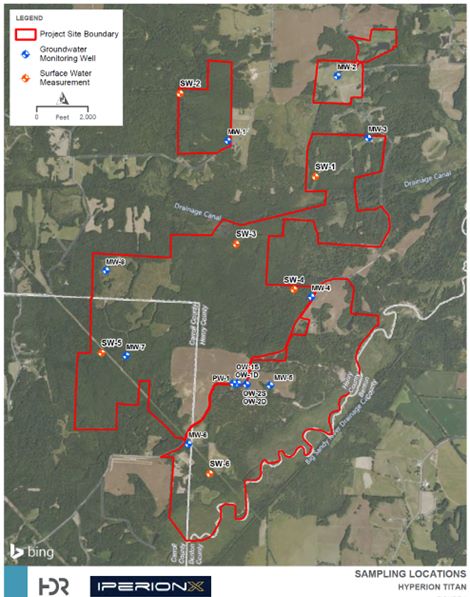
Figure 11: Groundwater and surface water sampling locations, by HDR, July 2022
| 7.3.1 |
Aquifer Properties
|
| • |
Transmissivity ranged from 130-223 m2/day in the shallow aquifer (shallow) and 167-223 m2/day in the deeper portion of the unconsolidated aquifer (deep);
|
| • |
Hydraulic conductivity ranged from 4.8-8.1 m/day (shallow) and 6.1-8.1 m/day (deep);
|
| • |
Storativity ranged from 1.5 x 10⁻¹ – 8.8 x 10⁻² (shallow) and 2.1 x 10⁻¹ – 4.6 x 10⁻⁵ (deep).
|
| 7.3.2 |
Groundwater
|
The groundwater monitoring network consisted of eight monitoring wells (MW-1 through MW-8), one aquifer test pumping well (PW-1), and four paired (shallow and deep) observation wells (OW-1S, OW-1D, OW-2S, and OW-2D).
Monitoring wells were installed to provide baseline groundwater quality data prior to mining. The pumping and observation wells were installed to facilitate a 72 hr aquifer test.
Page 38 of 89
IPERIONX TITAN PROJECT, TENNESSEE – TECHNICAL REPORT SUMMARY
Subsequent to well installation, HDR conducted a 72 hr aquifer pumping test from 8–11 June 2022 at pumping well PW-1. The aquifer test was used to estimate the physical parameters of the aquifer to understand
information on well frequency and pumping rates for potential dewatering. Test results were analyzed using the Cooper-Jacob and Theis straight line methods for time drawdown, residual drawdown/recovery, and distance drawdown.
Six bi-monthly groundwater level gauging tests were conducted from June 2021 to April 2022. Depth to water from the top of well casing was recorded using an electronic water-level meter. Depths to water ranged from
6.96 feet below the top of the casing in MW-6 (February 2022) to 26.7 m below the top of the casing in OW-2D (April 2022). Based on the groundwater elevational data obtained between June 2021 and April 2022, potentiometric surface maps were
generated for each gauging event. In general, groundwater flows from an elevational high at MW-7 toward topographic lows near MW-1, MW-4, MW-6, and MW-8. The predominant direction of local groundwater flow is east–southeast toward the Big Sandy
River.
Groundwater samples were collected by HDR during six sampling programs between June 2021 and April 2022. Purging was conducted via low-flow methods and was considered complete when the water table and field
parameters had stabilized in accordance with the criteria specified below. Field measurements were obtained using a calibrated water quality meter, and included:
| • |
Turbidity (10% for values greater than 5 NTUs (if three turbidity values are <5 nephelometric turbidity units (NTUs), the values are considered stabilized).
|
| • |
Dissolved oxygen (DO) (10% for values greater than 0.5 mg/L, if three DO values are <0.5 mg/L, the values are considered stabilized).
|
| • |
Specific conductance (3%).
|
| • |
Temperature (3%).
|
| • |
pH (± 0.1 unit).
|
| • |
Oxidation reduction potential (ORP) (± 10 millivolts).
|
Samples were placed on ice and shipped under chain of custody procedures to Pace Analytical Services LLC for analysis. Sample handling and custody were performed in accordance with the US Environmental Protection
Agency Guidance for Field Samplers.
Groundwater sample results of analyses were compared to the Tennessee Department of Environmental Quality General Water Quality Criteria (the criteria) established in Rule 0400-40-03.03(1)(j) for protection of
domestic water supplies. A summary of the results is as follows:
| • |
In MW-2, chromium exceeded the criteria of 100 μg/L with a concentration of 153 μg/L during the February 2022 sampling event.
|
| • |
In MW-3, chromium exceeded the criteria of 100 μg/L with a concentration of 368 μg/L during the February 2022 sampling event.
|
| • |
In MW-4, arsenic exceeded the criteria of 10 μg/L with a concentration of 10.4 μg/L during the June 2021 event. Lead exceeded the criteria of 5 μg/L with concentrations of 17.5 μg/L and 8.4 μg/L during the June 2021 and August 2021
sampling events, respectively.
|
| • |
In MW-8, cadmium slightly exceeded the criteria of 5 μg/L with a concentration of 6.5 μg/L during the June 2021 sampling event. Chromium exceeded the criteria of 100 μg/L with a concentration of 182 μg/L during the June 2021 sampling
event.
|
| • |
In OW-1D, chromium exceeded the criteria of 100 μg/L with concentrations of 442 μg/L (October 2021), 363 μg/L (December 2021), 406 μg/L (February 2022), and 170 μg/L (April 2022). Lead slightly exceeded the criteria of 5 μg/L with a
concentration of 7.8 μg/L during the June 2021 sampling event. Nickel exceeded the criteria of 100 μg/L with concentrations of 214 μg/L (October 2021), 200 μg/L (December 2021), and 245 μg/L (February 2022).
|
| • |
In OW-2D, chromium exceeded the criteria of 100 μg/L with a concentration of 160 μg/L during the August 2021 sampling event. Nickel slightly exceeded the criteria of 100 μg/L with a concentration of 103 μg/L during the August 2021
sampling event.
|
| • |
In PW-1, lead slightly exceeded the criteria of 5 μg/L with a concentration of 5.2 μg/L during the August 2021 sampling event.
|
Page 39 of 89
IPERIONX TITAN PROJECT, TENNESSEE – TECHNICAL REPORT SUMMARY
| • |
No exceedances were reported during the six sampling events between June 2021 and April 2022 in the samples collected from wells MW-1, MW-5, MW-6, MW-7, OW-1S, and OW-2S.
|
| • |
Field parameters were generally consistent for each well throughout the monitoring period. Groundwater is slightly acidic at the Site, and pH was below the TDEC GWQC of 6.0 during at least one, if not all, sampling events at each
location.
|
The presence of naturally occurring metals at concentrations exceeding Tennessee Department of Environmental Quality General Water Quality Criteria standards is common in the Highland Rim Physiographic Provence of
Tennessee. Exceedances likely do not represent anthropogenic effects, or groundwater quality violations, given the relatively undeveloped nature of the Project area.
| 7.3.3 |
Surface Water
|
HDR measured stream flow from six surface water locations (SW-1 through SW-6) during four programs between October 2021 and April 2022. Flow measurements at each surface water location were taken using the float
method and ranged from 274 L/sec at SW-4 in February 2022 to 5 L/sec at SW-1 in December 2021. SW-1, SW-5, and SW-6 were observed to be either stagnant or dry during at least one monitoring program.
HDR established six surface water sampling locations (SW-1 through SW-6) at creeks within the Project area to evaluate surface water quality. Grab samples were collected from each surface water sampling location
bi-monthly from October 2021 to February 2022 (SW-6 was also sampled in April 2022).
Prior to sample collection, field parameters (including temperature, conductivity, pH, ORP, and DO) were measured with a water quality meter.
Samples collected were analyzed for the following:
| • |
Metals using USEPA Method 6010D.
|
| • |
Mercury using USEPA Method 7470A.
|
| • |
Alkalinity using Standard Method (SM) 2320B.
|
| • |
Total dissolved solids (TDS) using SM 2540C.
|
| • |
Total Kjeldahl nitrogen using USEPA Method 351.2.
|
| • |
Nitrate and nitrite using USEPA Method 353.2.
|
| • |
Total nitrogen (calculation).
|
| • |
Chloride, fluoride, sulfate using USEPA Method 300.0.
|
| • |
Cyanide using SM 4500-CN.
|
Samples collected were compared to the Tennessee Department of Environmental Quality General Water Quality Criteria standards and no exceedances were observed during the sampling programs.
| 7.3.4 |
Groundwater Flow Model
|
HDR developed a groundwater model in December 2022 to estimate the amount of water that would need to be pumped out to allow future mining activities, and the effects of such pumping on groundwater levels.
Dewatering and its effects on regional groundwater resources were simulated using a three-dimensional (3-D) groundwater flow model using the US Geological Survey (USGS) groundwater modeling software MODFLOW-USG. HDR
compiled hydrogeological data to create a digital conceptual site model using Aquaveo GMS, a 3-D groundwater model pre-processing software. Once the model reasonably reproduced measured conditions (e.g., aquifer tests conducted at the site), the
model was used to simulate future dewatering conditions. Data from on-site testing and drilling, as well as from regional and national sources such as the Tennessee Geological Survey, National Oceanic and Atmospheric Administration, and the USGS,
were compiled into a 3-D database to develop the digital conceptual site model.
Page 40 of 89
IPERIONX TITAN PROJECT, TENNESSEE – TECHNICAL REPORT SUMMARY
The groundwater model assumptions include the following:
| • |
The steady-state flow model was calibrated to hydraulic heads measured at monitoring wells in summer 2021 to spring 2022. The model does not account for changing recharge or stage of the Big Sandy River and is not calibrated to match
transient (time varying) measurements of groundwater levels. The steady-state calibration does not consider groundwater storage. Storativity values used in the model were taken from aquifer testing conducted at the site.
|
| • |
Model calibration targets represent the limited period when monitoring was undertaken. The variability of conditions could be larger than represented by the monitoring data and the monitoring data could represent outlier conditions which
bias the model outcome. This potential for bias creates some uncertainty in the model outcome.
|
| • |
Heterogeneity in the subsurface conditions may not be fully captured by the geological data used to create the model and is necessarily generalized in the model. Such varying conditions result in uncertainty in the model outcome.
|
| • |
It is assumed that constant-density Darcian-flow conditions occur throughout the model domain at all times such that MODFLOW is an acceptable code to simulate the movement of groundwater in the shallow subsurface. Conditions may occur
occasionally in which these assumptions do not hold. Examples would include: 1) seasonal temperature changes of the Big Sandy River affecting groundwater temperatures, thereby changing the viscosity and density of water, and thus the
assumed constant hydraulic conductivity of the aquifer materials; and 2) when the same effects occur due to increase of concentrations of dissolved mass in the groundwater system. These conditions likely contribute to uncertainty in the
model; however, other factors such as unknown heterogeneous subsurface conditions and time variability in aquifer stresses and recharge are likely larger sources of uncertainty.
|
The groundwater model shows that the effects of dewatering on the streams, wells and wetlands are variable over time depending on the areas that would be dewatered and refilled. For the most part the effects on these
water resources are minimal and transient. Based on the model results, the identified wells should not experience noticeable changes in yield during pumping operations. The impacts on base flow to wetlands and streams will be dependent upon what
time of year the greatest effects occur (i.e., base flow impacts can be offset by run-off during wetter times of the year) but would be transient and likely short-lived. Once the dewatering operation has completed, the streams, wells and wetlands
should return to their pre- dewatering states.
| 7.4 |
Geotechnical Data
|
No geotechnical programs have been completed.
Page 41 of 89
IPERIONX TITAN PROJECT, TENNESSEE – TECHNICAL REPORT SUMMARY
| 8 |
Sample Preparation, Analyses, and Security
|
| 8.1 |
Sample Collection and Security
|
Roto-sonic drill core samples, typically 3 m in length, were collected directly from the plastic sample sleeve at the drill site. Some interpretation was involved as the material could expand or compact as it was
recovered from the core barrel into the plastic sleeve. Samples were collected at regular 1.5 m intervals unless geological contacts were encountered. Sample length ranged from 0.3 m to 4.5 m. The samples that were not consistent with the 1.5 m
sampling interval accounted for 0.05% of all samples.
The unconsolidated sonic cores were sampled by splitting the core in half lengthwise using a machete, then recovering an even fillet with a trowel along the entire length of the sample interval. The sample volume was
about 2 kg and was appropriate for the analytical method(s) being used and ensured adequate sample volume was collected. Samples were collected directly to pre-labeled/pre-tagged sample bags; the remaining sample was further split into a
replicate/archival sample. What sample remained after these steps was used to backfill the drill hole.
Sample bags were sealed with a zip tie at the drill site, placed in rice bags, and remained in the custody of the field geologist from time of collection until time of delivery to the Project’s temporary storage
location. This was either a secure third-party storage unit or a leased barn. A red security tag was used to secure the top of each rice bag, and these tags were verified by the laboratory to confirm all sample bags were intact when delivered to
the laboratory.
| 8.2 |
Laboratory Procedures
|
Drill samples were sent to the SGS facility in Lakefield, ON, Canada (SGS Lakefield). SGS Lakefield is a qualified third-party laboratory that is independent of IperionX. SGS Lakefield is accredited as an ISO 17025
facility for selected analytical techniques.
Samples were subjected to standard mineral sand industry assay procedures of size fraction analysis, heavy-liquid separation, and chemical analysis.
Samples were initially weighed, homogenized and a ~1 kg subsample was submitted for analysis, The remaining material was retained for potential later test work. The subsamples were dry screened at 44 µm (325 mesh)
for slimes and 595 µm (30 mesh) for oversize. The oversize material was weighed, and the remaining mass was attributed to the slimes fraction.
An 85 g aliquot of the -30/+325 sand was submitted to heavy liquid separation via methylene iodide diluted with acetone to target a specific gravity of 2.95 g/cm3 as this is more dense than non-valuable minerals, and less dense than the target heavy minerals, allowing for the target minerals to sink in the solution. The >2.95 g/cm3 portion was dried and weighed to calculate the percent heavy minerals within this size fraction by dividing the mass of heavy minerals by the total mass of the -30/+325 aliquot.
The total heavy mineral content was calculated by adding the percent slimes and oversize to the total.
Heavy minerals mass
-30/+325 mass+(-30/+325 mass * % slimes)+(-30/+325 mass * % oversize)
Composites, based on geological domains, were submitted for quantitative evaluation of materials by scanning electron microscopy (QEMSCAN) analysis for mineralogical assemblage data. The mineral species determined
from QEMSCAN from SGS Lakefield were further combined and/or divided into groups representing anticipated products based on metallurgical test work for inclusion in the geological block model.
Page 42 of 89
IPERIONX TITAN PROJECT, TENNESSEE – TECHNICAL REPORT SUMMARY
| 8.3 |
QAQC Controls
|
Accuracy monitoring was addressed by submission of in-house heavy mineral sand standards developed specifically for the Project. There is no commercially available standard reference material for heavy mineral sand
deposits. It is a common method within heavy mineral sands exploration and operations to generate standards that represent a matrix match to the target material being analyzed. A low-grade (~1 % heavy minerals) and a high-grade (>2 % heavy
minerals) standard were produced with materials (HMs and silica sand) from the Project area to ensure matrix and mineralogical representativeness. Each material was analyzed by SGS Lakefield to generate mean and standard deviations. Standardss and
blanks were inserted at a 2.5% rate (one for every 40 samples). These standardss and blanks were placed loose in a standard sample bag that was labeled sequentially as to mimic a typical drill sample and passed through the laboratory process
“blind”. A record of the standards inserted, and the sample IDs is kept in the Project database so that data can be matched up and reviewed. Standards were created multiple times during the Project and each time a new dataset was generated to
compare against.
A quality control standard failure was considered to be any single standard three standard deviations from the true value for the comparison for each sample, or two out of three consecutive samples between two and
three standard deviations, on the same side of the mean value (i.e. both above or both below the mean value). Should the errors for a particular batch exceed these limits, the section of a batch bracketed by the standard samples (i.e. number
samples on either side) were reviewed to determine if the standard failures were material to the overall data for that batch or if the laboratory had had any procedural issues that need to be addressed. If necessary, samples were re‐analyzed.
Eleven standards (six high- and five low-grade) were submitted during the drilling campaign for analysis and results were all within three standard deviations of the mean of the standard.
Sampling precision was monitored by selecting a sample interval at a 3% rate (three for every 100 samples) and taking a second sample from the replicate over the same sample interval. These samples were consecutively
numbered after the primary sample and recorded in the sample database as “field duplicates” and the primary sample number recorded. Field duplicates were ideally collected when sampling mineralized sonic core intervals containing visible total
heavy minerals (panning), 71% of the duplicate samples were in samples grading 0.5% THM or higher.
IperionX considered that field duplicates should have an average coefficient of variation of <10%, whereas laboratory duplicates should have an average coefficient of variation of <5%. For the drilling results
reported, 83 field duplicates were submitted to the laboratory with results showing a coefficient of variation of <10%. Analysis of field duplicates indicates a relative precision of 31, indicating that the drill sampling was the greatest
source of uncertainty in the sampling procedure.
Analytical precision was monitored using heavy liquid separation duplicates that the laboratory produced at a rate of approximately three in 100 samples. The use of an 85 g sub-sample for heavy liquid separation
resulted in a relative precision of 4% based on repeat analyses of standard reference materials at SGS Lakefield. This sub-sample mass was considered to be appropriate for the grain size being sampled.
| 8.4 |
Database
|
Database entry was completed after every field day. Field data, including geology, notes on mineralogy, sample type, and collar information (coordinates, landowner, hole length, status, drill rig used, geologist, and date drilled) were manually
input into a GeoSpark database from field logging booklets and checked for accuracy. Daily backups were completed.
Laboratory assay reports from SGS Lakefield were delivered in an Excel worksheet format and total heavy mineral percentages were calculated using a designated formula:
HLS sink/(Total+(Total*Oversize/100) + (Total*slimes/100))*100.
Assay values were validated using Excel-based conditional formatting. Results were then uploaded directly to GeoSpark in a designated “Assays” tab.
Mineral composition data was similarly delivered from SGS Lakefield in Excel format and uploaded to a “Mineral Composition” tab in GeoSpark.
Logging booklets were kept in ascending order at the field site.
Page 43 of 89
IPERIONX TITAN PROJECT, TENNESSEE – TECHNICAL REPORT SUMMARY
| 8.5 |
Opinion of Qualified Person
|
KGS is of the opinion that the sample preparation, security, and analytical procedures are sufficient to reasonably support mineral resource estimation.
Page 44 of 89
IPERIONX TITAN PROJECT, TENNESSEE – TECHNICAL REPORT SUMMARY
| 9 |
Data Verification
|
| 9.1 |
Data Verification Completed by the Qualified Person
|
KGS conducted several site visits throughout the drilling campaigns and metallurgical test programs. KGS also visited the Mineral Technologies laboratory SGS Lakefield. These visits are discussed in Chapter 2.4.
The site visits provided visual confirmation of mineralization, drill hole locations, bulk sample collection and logging and sampling procedures. KGS is satisfied with the laboratory procedures as witnessed during
the Mineral Technologies laboratory inspection. The laboratory procedures witnessed during the KGS inspection of SGS Lakefield are considered acceptable.
KGS provided training on logging, sampling, material interpretations and density measurements. KGS and IperionX staff had regular database validations to ensure data quality was sufficient.
| 9.2 |
Limitations Placed on Data Verification
|
No limitations were requested by IperionX of KGS when verifying data, and KGS performed data verification as applicable to support mineral resource estimation.
| 9.3 |
Opinion of Qualified Person
|
KGS is of the opinion that the data are of a high quality and that no systemic or procedural issues that could impact the exploration results or mineral resource estimation are present that have not been discussed in
this Report.
Page 45 of 89
IPERIONX TITAN PROJECT, TENNESSEE – TECHNICAL REPORT SUMMARY
| 10 |
Mineral Processing and Metallurgical Testing
|
Two test work programs were conducted within the mineral resource estimate area, one in 2021 and the second in 2023. All test work was completed on behalf of IperionX.
Test work was completed by, or under the supervision of, Mineral Technologies. The company is a reputable testing organization, with laboratories with significant experience in mineral sands flowsheet development
located in Florida, and in Queensland, Australia. The laboratories are ISO 9001, 45001 and 14001 accredited. Mineral Technologies is independent of IperionX. A portion of the test work was completed at IperionX’s Camden mineral demonstration
facility, under the supervision of Mineral Technologies personnel. Neither facility is accredited for metallurgical test work procedures; this is routine for metallurgical testing facilities as there is currently no organization that certifies
laboratories specifically for metallurgical test work.
Assays were conducted by SGS Lakefield, and Bureau Veritas in Perth, Australia, using X-ray fusion (XRF), laser ablation/inductively-couple plasma mass spectrometry (ICP–MS) and QEMSCAN analytical methods. Bureau
Veritas is independent of IperionX and holds ISO 17025 accreditations for selected analytical techniques.
| 10.1 |
2021 Metallurgical Test Results
|
Three bulk samples were processed by Mineral Technologies through pilot equipment designed to emulate a full-scale feed preparation plant, wet concentrator plant, monazite flotation/concentrate upgrade plant and a
mineral separation plant.
The samples were taken from drill hole 20-SWW-004 (B004), 21-SBF-047 (B047), and 20-SWW-014 (B014). The B004 and B047 samples were sourced from the Lower McNairy Formation. B014 was sourced from the Upper McNairy Formation. Mineralization in
the Upper McNairy Formation is significantly coarser than mineralization in the Lower McNairy Formation. The approximate mass of each sample was:
| • |
B004: approximately 512 kg of sample.
|
| • |
B047: approximately 496 kg of sample.
|
| • |
B014: approximately 483 kg of sample.
|
Test work demonstrated that the Upper and Lower McNairy Formation mineralized zones could be separated using processing stages common to most mineral sands operations.
Page 46 of 89
IPERIONX TITAN PROJECT, TENNESSEE – TECHNICAL REPORT SUMMARY
The 2021 metallurgical test work block flow diagram is depicted in Figure 12.
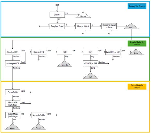
Figure 12: 2021 Metallurgical test block flow diagram, by Mineral Technologies, Sep.2021
| 10.1.1 |
Sample Preparation and Deslime Circuit
|
Samples B004 and B047 were fluidized in a drum before being pumped via submersible pump to the deslime circuit.
The material was then pumped to a 100 mm hydro cyclone fitted with a 20 mm apex and 35 mm vortex finder. Based on visual observation during closed loop testing this combination resulted in the most reliable
performance with minimal loss of +45 μm solids to the overflow stream as determined by test sieving at 325 mesh.
Timed samples were collected, consolidated, dried, weighed, and submitted for assay. The deslime circuit was then converted to open circuit operation and the entire bulk sample was processed.
Sample B014 was processed using conventional preparation equipment, including a feed belt and rotary trommel fitted with a 2 mm screen. The 20 mm apex and 35 mm vortex finder combination were used for sample B014.
After identifying the appropriate operating conditions, the deslime circuit was converted to open circuit and the entire bulk sample was processed.
The preparation and deslime test work demonstrated that:
| • |
Both the Lower McNairy Formation (B004 and B047) and Upper McNairy Formation (B014) samples contained elevated slimes, primarily highly cohesive clays.
|
| • |
The deslime process liberated clays and ultra-fines from the mineralization. All three samples showed reduction in -45 μm content when comparing the analysis to the deslime underflow.
|
Page 47 of 89
IPERIONX TITAN PROJECT, TENNESSEE – TECHNICAL REPORT SUMMARY
| • |
The deslime process resulted in a modest increase in TiO2/ZrO2 grade for
samples B047 and B014. Sample B004 saw a minor increase in ZrO2 grade and a minor decrease in TiO2 grade.
|
| 10.1.2 |
Wet Process Circuit
|
After desliming, each sample was subjected to release curve testing and bulk processing through the general flowsheet. Each stage of spiral testing followed the same general process: material was pumped over the
spiral on the test rig in a closed-circuit loop at a desired flow rate and pulp density. Multiple tests were done at a similar mass flow rate and pulp density while varying splitter positions to generate sets of release curve samples. The samples
were later assayed giving rise a suite of grade and recovery data points. These data were later used to generate release curves for each combination of mineralization and operating conditions. After release curve testing was complete for each
stage, the entirety of each feed material was processed at the best spiral conditions based on experience with similar mineralization, as well as in-process observations. Care was taken to ensure the addition rate of new feed material matched the
product withdrawal rate .
The wet process circuit test work demonstrated that:
| • |
After desliming, both the Lower and Upper McNairy Formation samples were amenable to conventional wet gravity separation via spiral separators.
|
| • |
The MG12 spiral is superior to the FM1 spiral for rougher stage processing of Lower McNairy Formation mineralization. The MG12 showed the highest separation efficiency for both samples at higher capacity than is achievable on an FM1
spiral.
|
| • |
The MG12 spiral is better for rougher stage processing of Upper McNairy Formation mineralization.
|
| • |
The MG12 spiral performed well in the cleaner stage for all samples.
|
| • |
Additional upgrade stages will be required to reach generally acceptable heavy mineral concentrate grades on finer Lower McNairy Formation mineralization.
|
| 10.1.3 |
Dry Process Circuit
|
Heavy mineral concentrate generated from the B004, B047, and B014 samples was used for dry process evaluation.
After attrition, scrubbing, and drying, each heavy mineral concentrate sample was subjected to dry processing through the flowsheet. The B004 and B047 samples were processed using the same conventional flowsheet;
however, additional separation stages were added to the B014 flowsheet due to elevated aluminosilicate mineral content.
The dry process circuit test work demonstrated that:
| • |
The Lower McNairy and Upper McNairy Formation samples were amenable to conventional dry physical separation via:
|
| o |
Screening.
|
| o |
MT Carrara HTR400 high-tension roll separator.
|
| o |
MT Carrara electrostatic plate separator.
|
| o |
MT Readings rare earth drum magnetic separator.
|
| o |
MT Readings rare earth roll magnetic separator.
|
| o |
MT Readings induced roll magnetic separator.
|
The following conclusions were drawn from the 2021 test work:
| • |
Both the Lower and Upper McNairy Formation mineralization will require thorough desliming to properly prepare the ore for wet gravity processing.
|
| • |
Both the Lower and Upper McNairy Formation mineralisation is amendable to conventional wet gravity processing via spiral separators. The MG12 is the better spiral model for rougher and cleaner duty.
|
| • |
Ilmenite, rutile, zircon, and monazite concentrate products can be produced from both Lower and Upper McNairy Formation mineralization.
|
| • |
Further testing is required to outline wet processing flowsheets and equipment configurations to maximize recovery, particularly of the fine Lower McNairy Formation mineralization.
|
Page 48 of 89
IPERIONX TITAN PROJECT, TENNESSEE – TECHNICAL REPORT SUMMARY
| • |
The finer Lower McNairy Formation mineralization poses a challenge in dry processing. Additional processing stages will likely be required to improve ilmenite, rutile, and zircon recovery.
|
| 10.2 |
2023 Metallurgical Test Results
|
Mineral Technologies completed additional metallurgical test work in early 2023.
The test work was based on one bulk sample and three variability samples.
The main bulk sample of 12.7 t was composed of approximately 30% Upper McNairy and 70% Lower McNairy Formation mineralization, representing the average material that might be mined in the initial years of any future mining operations. Samples
used to make up the bulk sample were taken from drill holes 20-SWW-014, 20-SDW-020, 20-SDW-021, 21-SGH-034,21-SGH-035, 21-SGH-037, 21-SDW-054,21-SDS-055, 21-SWW-069, 21-SSP-083, 21-SGH-084, and 21-SGH-086.
Three bulk composite samples ranging from 2–3 t was prepared for the variability test work, taken from drill holes 20-STV-008, 20-STS-016, and 21-SDS-058. The composites consisted of different ratios of Upper McNairy and Lower McNairy Formation
material, with the mass percent of Upper McNairy Formation in the composites being 0%, 37.5% and 50%. The objective of the variability test work was to quantitatively assess potential product quality with qualitative estimates of recovery of three
composite samples that reflected different mineralized domains.
| 10.2.1 |
Feed Preparation
|
The feed preparation process was conducted at IperionX’s mineral demonstration facility near Camden with the supervision of Mineral Technologies personnel.
The 10 t (dry) of raw test sample material was packed into 208 L (55-gallon) drums. The contents of the drums were washed through a 0.635 cm (¼”) punch plate into a mixing tank. Any oversize from the punch plate was collected and dried.
Sufficient material and water were added until a cyclone feed pump discharge density of 15–20% (estimated using a Marcy scale with an approximate 2.7 specific gravity) in closed circuit. Upon achieving steady state, the cyclone overflow was
diverted to a settling pond in which effluent overflowed into a reservoir. The circuit was continually supplied with make-up water to maintain the level of the tank. Once the recirculating material was sufficiently deslimed, the cyclone underflow
was diverted to the screw classifier before being discharged into new 208 L (55-gallon) drums.
This semi-batch operation was repeated until all the feed material was processed through the feed preparation circuit. Frequent sub-samples of the feed and cyclone overflow were taken throughout the process to form representative composites for
further characterisation and analysis.
| 10.2.2 |
Wet Gravity Separation
|
The wet gravity processing up to the recleaner stage was completed at Mineral Technologies Florida laboratory. The material received was processed through a continuous trommel/screen and spiral circuit. The trommel discharged any oversize
material >2 mm. The undersize from the trommel was pumped to a distributor which fed into a single-stack spiral circuit.
The bulk products up to the recleaner stage were freighted to Mineral Technologies’ metallurgical testing facility in Queensland, Australia where subsequent wet gravity processing was completed. Damp material was conveyed into a spiral rig sump
which was pumped into a single-stack spiral circuit.
Page 49 of 89
IPERIONX TITAN PROJECT, TENNESSEE – TECHNICAL REPORT SUMMARY
The block flow diagram shown in Figure 13 was used for feed preparation and wet gravity processing.
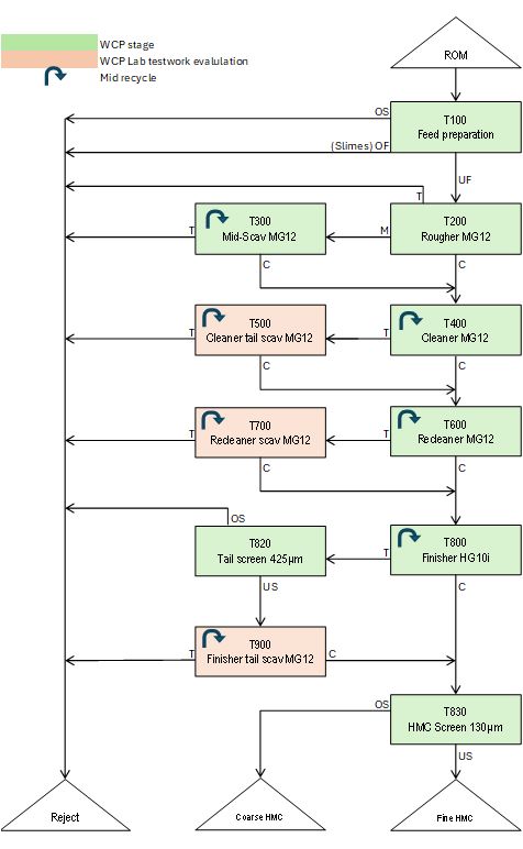
Figure 13: Feed preparation and wet gravity processing test block flow diagram, by Mineral Technologies, April 2023
Page 50 of 89
IPERIONX TITAN PROJECT, TENNESSEE – TECHNICAL REPORT SUMMARY
This test work incorporated a total of eight stages, three of which were laboratory evaluations to emulate how particular recycle streams would perform in a plant scenario. For each of the spiral stages, except the rougher, the middlings streams
were recirculated with the feed to maximise recovery of heavy minerals.
Prior to bulk processing of the mineralization through each spiral stage, several lots of release tests were conducted in closed circuit. The results from release tests are used in Mineral Technologies’ proprietary modelling software to provide
stage grade/recovery models and incorporate them into overall mass balances.
Two mass loadings of 1.5 and 2.0 tph were selected for release tests for each of the main spiral stages, with a pulp density target range of 30-40%. For the bulk processing, 1.5 tph was selected as the operating loading to increase retention
time of minerals on the spiral and allow for better separation to occur.
| 10.2.3 |
Rare-Earth Flotation and Gravity Upgrade
|
The main objective of the flotation stage was to extract all available rare-earth minerals from a fine heavy mineral concentrate stream, leaving a tailings barren of monazite.
The following steps outline the procedure for flotation test work for both sighter and bulk batch tests: pretreatment; depressant addition; pH modification; collector addition; water level adjustment and collection.
Successive iterations of collector addition, conditioning, frothing and recovery were conducted until either no further mineral was floating, or non-selective minerals start to float. The number of iterations and collector quantities varied from
test to test.
Post flotation, both concentrate and tailing were washed and attritioned to remove residual chemical prior to wet table test work. Samples were dried, weighed, and sub-samples extracted for analysis.
| 10.2.4 |
Fine Mineral Separation – Primary High Tension Roll Circuit
|
Fine mineral separation block flow diagram is shown in Figure 14.
A Carrara HT400 (400 mm diameter roll) was used for high tension roll stages in all mineral separation plant circuits. The laboratory unit is a single roll unit, but fractions were re-passed to simulate a three-roll production unit.
A conventional primary high-tension circuit involving rougher, non-conductor cleaner, conductor cleaner and scavenger stage was used.
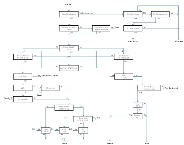
Figure 14: Fine mineral separation test block flow diagram, by Mineral Technologies, April 2023
Page 51 of 89
IPERIONX TITAN PROJECT, TENNESSEE – TECHNICAL REPORT SUMMARY
| 10.2.5 |
Fine Mineral Separation – Non-Conductor Circuit
|
The non-conductor was processed through a stage of dry magnetic separation to separate out magnetic silicates.
Previous test work showed a high degree of separation was achieved using a rare earth roll magnetic separator on the non-conductor fraction. A single roll rare earth roll magnetic separator unit was used with fractions re-passed to simulate a
three-roll production unit.
The non-magnetic fraction from the staurolite rare earth roll magnetic separator was fed to the zircon wet circuit for the removal of quartz and aluminum silicates. A up current classifier was tested for the initial stage of separation as it was
hoped an underflow could be produced that would be sufficiently low in SiO2 and Al2O3 to not require further gravity upgrading, thus reducing the size of the wet circuit.
The up-current classifier underflow and overflow fractions were separately processed through a wet shaking table circuit.
The dried zircon concentrate was processed through a two-stage, rougher-scavenger high tension roll circuit to reject residual conductive material. A three-roll HT400 was used for the stages with similar settings in the primary high tension roll
circuit.
Page 52 of 89
IPERIONX TITAN PROJECT, TENNESSEE – TECHNICAL REPORT SUMMARY
| 10.2.6 |
Fine Mineral Separation – Conductor Circuit
|
The conductors from the primary HT circuit were processed through a dry conductor circuit to produce ilmenite/leucoxene and rutile products.
Previous scoping test work on similar Camden feed proved the rare earth roll magnetic separator separator was effective at fractionation of titania minerals.
The non-magnetic fraction from the conductor rare earth roll magnetic separator was processed through a single stage, three-pass HTR400 to extract non-conductive impurities from the rutile. Similar settings in the primary high tension roll
circuit were used for the rutile high tension roll circuit.
The combined conductors were processed through magnetic separation to further remove magnetic impurities from the rutile product.
| 10.2.7 |
Coarse Mineral Separation – Primary HTR Circuit
|
Coarse mineral separation block flow diagram is shown in Figure 15.
The coarse heavy mineral concentrate had a total heavy minerals content of ~89%. At the time of the test work, additional upgrading was deemed unnecessary.
An identical test work procedure was used for the coarse mineral separation plant, with the exception of an additional screen on the primary conductor stream. The operating conditions were adjusted as necessary through each stage to accommodate
for the coarser feed and different mineralogy. The flowsheet was shown in Figure 14.
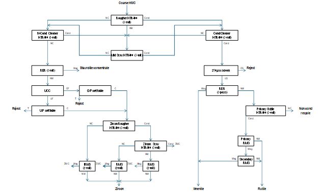
Figure 15: Coarse mineral separation test block flow diagram, by Mineral Technologies, April 2023
Page 53 of 89
IPERIONX TITAN PROJECT, TENNESSEE – TECHNICAL REPORT SUMMARY
| 10.2.8 |
Coarse Mineral Separation – Non-Conductor Circuit
|
The non-conductors were processed through a stage of dry magnetic separation to generate a magnetic concentrate by-product.
A single role rare earth roll magnetic separator unit was used with fractions re-passed to simulate a three-roll production unit.
The non-magnetic fraction from the rare earth roll magnetic separator was processed through an up-current classifier.
The up-current classifier underflow and overflow fractions were separately processed through a wet shaking table circuit.
The re-processed zircon concentrate was passed over a two-stage, rougher-scavenger high tension roll circuit to reject residual conductive material. A HT400 was used for the stages with similar settings in the primary high tension roll circuit.
| 10.2.9 |
Coarse Mineral Separation – Conductor Circuit
|
The conductors from the primary high-tension circuit were processed through a dry conductor circuit to produce ilmenite/leucoxene and rutile products.
The primary conductor material contained coarse non-conductors. This was typical of a primary conductor with a coarser feed. To prevent the misreporting coarse material from contaminating the conductor products, a screen was incorporated for the
primary conductors to reject coarse non-conductors.
A rare earth roll magnetic separator was used on the primary conductor undersize to fractionate the conductor minerals.
The same operating parameters were used as the fine mineral separation plant conductor rare earth roll magnetic separator with slight adjustments to the splitter positions.
The non-magnetic fraction from the conductor rare earth roll magnetic separator was processed through a single stage, three-pass HTR400 to extract non-conductive impurities from the rutile. Similar settings in the primary high tension roll
circuit were used for the rutile high tension roll circuit.
The combined conductor was processed through another stage of magnetic separation to remove residual magnetic minerals from the rutile product. A two-stage induced roll magnetic separator circuit was used. The middlings from the primary rutile
induced roll magnetic separators were re-treated in the secondary stage.
| 10.2.10 |
Products Grade
|
The final products, ilmenite, rutile, zircon, rare earth mineral concentrate, were produced from the 2023 test work. Ilmenite graded 64.9%TiO2, and the rutile graded
91.2% TiO2. The zircon graded 66.8% ZrO2. The rare earth mineral concentrate had a total
rare earth oxide (TREO) grade of 59.1%.
The product grades generally align with 2021 scoping test work results and were considered to be saleable products.
| 10.3 |
Flowsheet Development
|
The test work showed that high-quality ilmenite, rutile, zircon products could be achieved using conventional separation equipment through a typical wet concentrator plant and fine and coarse mineral separation plant flowsheet. A rare earth
mineral concentrate product was created at a high monazite recovery using a wet rare earth mineral concentrate circuit.
Page 54 of 89
IPERIONX TITAN PROJECT, TENNESSEE – TECHNICAL REPORT SUMMARY
Flowsheet development was conducted based on the main sample test work. The variability testwork mirrored the flowsheet of the main sample where practical. Despite the variance in the flowsheet procedure, mineralogy and feed grades, the
variability test work showed that high-grade ilmenite, rutile and zircon products could be achieved using the process flowsheet developed during testing.
The proposed process flowsheet is shown in Figure 16.

Figure 16: Proposed flow sheet based on metallurgical test work
ROM: Run-of-Mine; FPP: Feed Preparation Plant; WCP: Wet Concentration Plant; HMC: Heavy Mineral Concentrate; REMP: Rare Earth Mineral Plant; REMC: Rare Earth Mineral Concentrate; CUP: Concentrate
Upgrade Plant; MSP: Mineral Separation Plant
The proposed process flow sheet would include the following conventional process steps.
| • |
Mining unit plant:
|
| o |
Run-of-mine material will be delivered for primary deagglomeration through scrubbing and removal of large oversize to allow long-distance pumping.
|
| • |
Feed preparation plant:
|
| o |
The sand fraction containing the potentially valuable minerals (nominal -2.0+0.045 mm) will be separated from slimes (-45 µm) and oversize waste (+2.0 mm).
|
| • |
Wet concentration plant:
|
| o |
The potentially valuable minerals contained in the sand fraction would be recovered in a wet concentration plant using a conventional multi-stage gravity separation circuit. Intermediate size classification would be included to reject
other oversize waste
|
| o |
The recovered potentially valuable minerals would constitute the total heavy mineral concentrate, which would be screened at a nominal 130 µm to prepare coarse and fine heavy mineral concentrate streams.
|
| o |
Gangue minerals would be collected with oversize and slimes from the feed preparation plant, and then disposed as tailings backfilling the mining area.
|
| • |
Rare earth mineral plant:
|
| o |
The fine heavy mineral concentrate would be subjected to mechanical attrition and conditioned with specific reagents in readiness for processing by froth flotation and additional gravity concentration.
|
| o |
Scrubbing stages would be included to remove residual reagents from the flotation circuit outputs.
|
| o |
Products would be a rare earth mineral concentrate and a fine flotation heavy mineral concentrate.
|
| • |
Concentrate upgrade plant:
|
| o |
The fine flotation heavy mineral concentrate would be processed by wet gravity separation to produce a zircon and titania rich stream to feed the mineral separation plant.
|
| • |
Mineral separation plant:
|
| o |
The coarse and fine heavy mineral concentrates will be fractionated by multiple dry electrostatic and magnetic separation stages to produce a final ilmenite and rutile product. The non-conductors concentrate will be processed by wet
gravity then further dry electrostatic and magnetic separations to produce a final zircon concentrate.
|
Page 55 of 89
IPERIONX TITAN PROJECT, TENNESSEE – TECHNICAL REPORT SUMMARY
| 10.4 |
Metallurgical Recovery Forecasts
|
Circuit simulation models were generated for the wet concentration plant, rare earth mineral plant and mineral separation plant flowsheets to evaluate recycle streams and resultant mass flows. The expected future performance of the processing
plant was based on metallurgical test work results and benchmarked against other deposits that have similar characteristics to the Titan deposit.
The simulated recoveries for in-size sample (+45 μm material) from ROM to products are:
| • |
Rare earth mineral recovery of 82.6%.
|
| • |
Ilmenite recovery of 79.7%.
|
| • |
Rutile recovery of 66.9%.
|
| • |
Zircon recovery of 77.6%.
|
| 10.5 |
Metallurgical Variability
|
The three variability samples used in the 2023 metallurgical test work were composite samples representative of the different types and styles of mineralization within the Titan deposit. The variability bulk samples included coarse- and
fine-grained mineralization as well as areas of differing mineral assemblage.
| 10.6 |
Deleterious Elements
|
Deleterious elements such as iron, magnesium, uranium, thorium, chromium, and vanadium are present at low levels and can negatively impact the marketability of heavy mineral sands products, especially uranium and
thorium for the Project. High levels of these contaminants may reduce product quality, result in regulatory penalties, or require additional processing, which increases costs. Environmental considerations, particularly tailings management and the
potential presence of radioactive or toxic elements, can add complexity and expenses due to stricter regulations, water management, and the need for site rehabilitation after mining operations.
| 10.7 |
Opinion of Qualified Person
|
In KGS’ opinion, the test samples are representative of Titan deposit mineralization and the metallurgical test data are acceptable to use in mineral resource estimation.
Page 56 of 89
IPERIONX TITAN PROJECT, TENNESSEE – TECHNICAL REPORT SUMMARY
| 11 |
Mineral Resource Estimate
|
| 11.1 |
Introduction
|
The resource database contains sonic drill data collected between 2020–2021. Data are from 107 drill holes (4,101 m) and include 2,626 total heavy mineral assay samples (heavy liquid) and 181 total heavy mineral and composite mineralogy
(QEMSCAN) determinations.
Geological interpretations were compiled using Vulcan software. Variography was completed using R and Vulcan software version 2021.3. Vulcan software version 2021.3 was used for grade interpolation.
A parent block size of 100 x 200 x 1.5 m was used. Parent cells were typically centered on the drill holes with a floating cell centered between drill holes along and across strike. No sub-celling was used.
| 11.2 |
Geological Models
|
The geological model was based on the geological interpretations of lithology and mineralization from a series of east–west and north–south sections spaced 100 m apart. IperionX interpreted five lithological units. The Upper and Lower McNairy
Formation units were the units with the largest volumes; the fine-grained Lower McNairy Formation unit was preferentially mineralized with respect to heavy minerals.
IperionX modeled the soil zone, Upper McNairy Formation waste zones, Upper McNairy Formation mineralized zone, Lower McNairy Formation waste zone, Lower McNairy Formation mineralized zone and the Coon Creek Formation zone. The Lower McNairy
Formation zone accounted for most of the mineralized volume at approximately 67%, the remaining 33% percent of mineralized material is captured within the Upper McNairy Formation zone. No grade was attribute to the soil or Coon Creek Formation
zones.
No structural geology model was created.
KGS compared the plans and sections with logged data from the drill holes and concluded that there was acceptable three-dimensional consistency in the lithology and mineral type models and that the models respected the majority intervals in
lithology and mineral type recorded.
| 11.3 |
Density Assignment
|
Testing for bulk density was performed by taking 5 cm sections of the 10-cm sonic core, drying the samples to calculate the percent moisture and weighing.
The density value was developed from a collection of 200 samples from both the Upper and Lower McNairy Formation sand units.
Bench-scale bulk density measurements were collected that range between 1.38 t/m3 and 1.82 t/m3. A single bulk density of 1.65 t/m3 was used for the resource evaluation.
| 11.4 |
Grade Capping/Outlier Restrictions
|
No total heavy mineral top cut was used, nor was it considered necessary for this deposit due to the geology, style, and consistency of the mineralization.
| 11.5 |
Compositing
|
Samples were composited at 3 m intervals, based on an assumption of 6 m bench heights in an open pit mining operation. Composites honored mineralization contacts.
Page 57 of 89
IPERIONX TITAN PROJECT, TENNESSEE – TECHNICAL REPORT SUMMARY
| 11.6 |
Variography
|
Variograms are run to test spatial continuity within the selected geological domains.
Geostatistical analysis test of the Little Benton dataset using the drill hole spacing analysis method. This method attempts to quantify the uncertainty of applying a measurement from a central location to increasingly larger square blocks and
provides recommendations for determining the distances between drill holes for support when classifying measured, indicated, and inferred resources. The total heavy minerals percent data of the Lower McNairy Formation unit used for the analysis,
being the main mineralized unit.
The variogram plots average square difference against the separation distance between the data pairs. The separation distance is broken up into separate bins defined by a uniform lag distance (e.g., for a lag distance of 34 meters the bins would
be 0–34 m, 34–68 m, etc.). Each pair of data points that are less than one lag distance apart are reported in the first bin. If the data pair is further apart than one lag distance but less than two lag distances apart, then the variance is
reported in the second bin. The numerical average for differences reported for each bin is then plotted on the variogram. Care was taken to define the lag distance in such a way as to not overestimate any nugget effect present in the data set.
Lastly, modeled equations (gaussian, spherical or exponential) were applied to the variogram to represent the data set across a continuous spectrum.
| 11.7 |
Estimation/Interpolation Methods
|
Grade, slimes, and assemblage estimations were completed using inverse distance weighting to the third power (ID3) interpolation, which is appropriate for this style of mineralization.
Drill hole sample data were flagged with domain (zone) codes corresponding to the geological structure of the deposit and the domains imprinted on the model from three-dimensional surfaces generated from geological
interpretations.
A primary search dimension of 212 x 425 x 3 m (x, y, z) was used for all assay data. Successive search volume factors of two and four were adopted to interpolate grade in areas of lower data density. A search
orientation of 30 east of north was used to emulate the trend of the mineralization. No consistent plunge was apparent in the mineralization.
An octant search option was used with minimum of one and a maximum of five samples per octant, and a minimum of two octants being estimated to calculate the grade for a block. If insufficient data were found within
the first search, secondary and tertiary searches were used based on search volume factors. A minimum of two samples and a maximum of five samples could be used from any individual drill hole.
| 11.8 |
Block Model Validation
|
Visual validation compared the estimated grades in the block model to composite grades and composites along drill hole traces in both section and plan views. The block grades were considered to reasonably reflect the
composite grades.
The Titan deposit block models were estimated using nearest neighbor, inverse distance weighting to the second power (ID2), and ID3. The ID3 method was used for public reporting of the estimate.
| 11.9 |
Classification of Mineral Resources
|
| 11.9.1 |
Mineral Resource Confidence Classification
|
The resource classification was determined based on drill hole density reflecting the geological confidence; firstly, from the QEMSCAN hole locations and secondly from all holes with total heavy minerals:
| • |
Resource material with a radius of 212 m from QEMSCAN samples (having mineralogy data) was assigned a measured mineral resource classification.
|
Page 58 of 89
IPERIONX TITAN PROJECT, TENNESSEE – TECHNICAL REPORT SUMMARY
| • |
Resource material with a radius of 212 m from total heavy mineral % samples were assigned an indicated mineral resource classification.
|
| • |
Material with an approximate radius of 610 m from total heavy mineral% samples were assigned an inferred mineral resource classification.
|
Furthermore, radial arcs from points of measure were required to intersect with an adjacent similar arc of measure. Therefore, isolated, standalone holes with QEMSCAN samples were not assigned measured classification
and similarly, standalone holes with total heavy minerals were not assigned an indicated classification.
No measured mineral resources were reported. The indicated and inferred resource classifications were predominantly determined by the drill hole spacing, reflecting the geological confidence:
| • |
Mineralization defined by sampling within an approximate area of 212 mE–W by 425 mN–S by 3 mRL and having sufficient mineralogy data was assigned an indicated mineral resource classification. Approximately 56% of the estimated mineral
resources are classified as indicated.
|
| • |
Material defined by sampling with an approximate density of 305 mE–W by 610 mN–S by 3 mRL with some mineralogy data has been assigned an inferred mineral resource classification. Approximately 44% of the estimated mineral resources are
classified as inferred.
|
| 11.9.2 |
Uncertainties Considered During Confidence Classification
|
Table 6 summarizes the sources of uncertainties considered during confidence classification.
Table 6: Sources of uncertainties considered during confidence classification
|
Source of
Uncertainty
|
Discussion
|
|||
|
Drilling
|
All drilling has been roto-sonic drilling. The roto-sonic drill rig provides a representative sample, with sufficient recoveries of unconsolidated sand, in order to represent the in-ground material and is
suitable for use in mineral resource estimation.
|
|||
|
Sampling
|
Field duplicates are taken at a rate of 3% to identify biases or inconsistencies. Examination of these duplicates indicates satisfactory sampling performance e.
|
|||
|
Geological Modelling
|
The geological model is supported by sufficient drill data. The Coon Creek Formation is reached in >95% of the holes used the model. This provides a sufficient base to the extractable mineralization.
Discrimination between the upper and lower members of the McNairy Formation is easily identified by the relative difference in grain size and the presence of micas within the lower member.
|
|||
|
Estimation
|
The estimation techniques used are suitable for the deposit type and mineralization style. All data are log transformed and show normally distributed grade data. A validation infill program is recommended to
provide additional confidence in the estimation.
|
| 11.10 |
Reasonable Prospects for Economic Extraction
|
| 11.10.1 |
Initial Assessment Assumptions
|
To meet the content requirements of an Initial Assessment to support Mineral Resource estimates, KGS evaluated the content requirements set out in Table 1 of §229.1302 (Item 1302) “Qualified person, technical report summary, and technical
studies”.
IperionX had completed internal studies that reviewed potential mining methods, infrastructure locations, and process methods in 2022. KGS reviewed these studies when determining appropriate assumptions in support of reasonable prospects for
economic extraction.
Page 59 of 89
IPERIONX TITAN PROJECT, TENNESSEE – TECHNICAL REPORT SUMMARY
The assumptions used by KGS in support of the Initial Assessment are summarized in Table 7.
Table 7: Initial assessment assumptions
|
Factors
|
Initial Assessment
|
Titan Project
|
||||
|
Site
infrastructure
|
Establish whether or not access to power and site is possible. Assume infrastructure location, plant area required, type of power supply, site access roads, and camp/town site, if required.
|
General access to the Project is via a well-developed network of primary and secondary roads. The Project site can be accessed via highway 641 north 41.0 km from Interstate 40 near the town of Camden, TN,
Reynoldsburg Rd for 1.6 km, Pleasant Hill Rd for 1.6 km and the Little Benton Rd, a gravel road, for 4.8 km Little Benton Rd goes through the Project site.
Power is assumed to come from local power utilities.
The Project location was reviewed, and preliminary process plant location was proposed.
Personnel are assumed to live in surrounding communities. No accommodations camp would be required. Local active sand mining, gravel mining and timber operations will be sources of recruiting experienced
operators.
|
||||
|
Mine design &
planning
|
Mining method defined broadly as surface or underground. Production rates assumed.
|
Assumed to be mined using an open pit mining method with concurrent, progressive backfill and rehabilitation.
Assumed conventional truck-and-shovel equipment would be used in mining operations.
Assumed a production rate of 10 million metric tonne per year.
|
||||
|
Processing
plant
|
Establish that all products used in assessing prospects
of economic extraction can be processed with methods consistent with each other. Processing method and plant throughput assumed.
|
Products reported in the mineral resource statement can be processed with methods consistent with each other.
Assumed conventional processing for mineral sands projects, including feed preparation plant, wet concentrator plant, monazite separation plant, mineral separation plant.
|
||||
|
Environmental
compliance &
permitting
|
List of required permits & agencies drawn. Determine if significant obstacles exist to obtaining permits. Identify pre- mining land uses. Assess requirements for baseline studies. Assume post- mining land uses. Assume tailings
disposal, reclamation, and mitigation plans.
|
TDEC granted IperionX the required state Surface Mining Permit (OM-70711-01) and National Pollutant Discharge Elimination System Permit (TN0070711) on 14 August 2023. TN Surface Mining Permit is a five-year
permit and will need to be renewed and updated every five years. The first renewal will be required by 14 August 2028.
TDEC also determined that IperionX’s proposed sand processing operations would constitute an insignificant activity or insignificant emissions unit, as defined in part 1200-03-09-.04(2)(a)3. of the Tennessee
Air Pollution Control Regulations.
TDEC has confirmed that all regulatory permit requirements for the Titan Project phase 1 have been met by IperionX.
|
Page 60 of 89
IPERIONX TITAN PROJECT, TENNESSEE – TECHNICAL REPORT SUMMARY
|
Factors
|
Initial Assessment
|
Titan Project
|
||||
|
The pre-mining land is mostly timber land or agriculture land. IperionX recommends harvesting merchantable timber to help the local sawmill industry and generate biochar with the non-merchantable timber for
use during reclamation in the establishment of a vegetative cover.
Baseline groundwater and surface water assessment data collection was completed
The post-mining land is intended to be re-vegetated. The tailings will be backfilled to the mining void. The grading of the backfilled areas will be recontoured to be the approximate original contour, topsoil
replaced and site re-vegetated. IperionX is working with the University of Tennessee’s Institute of Agriculture to conduct research and field trials for sustainable development practices at Titan project, including a priority focus on land
rehabilitation best practices that improve post-mining land use and agricultural yield, and provide for carbon sequestration and carbon credit creation opportunities.
A detailed waste and tailings disposal as well as the site water management plan will be developed in the next phase of the study.
|
||||||
|
Other relevant
factors
|
Appropriate assessments of other reasonably assumed technical and economic factors necessary to demonstrate reasonable prospects for economic extraction.
|
Mineral resource estimates confined within a conceptual pit shell.
|
||||
|
Capital costs
|
Optional. If included:
Accuracy: ±50% Contingency: ≤25%
|
Not relevant to this Report.
|
||||
|
Operating
costs
|
Optional. If included: Accuracy: ±50% Contingency: ≤25%
|
Not relevant to this Report.
|
||||
|
Economic
analysis
|
Optional. If included: Taxes and revenues are assumed. Discounted cash flow analysis based on assumed production rates and revenues from available measured and indicated mineral resources.
|
Not relevant to this Report.
|
| 11.10.2 |
Input Assumptions Used to Constrain the Mineral Resource Estimates
|
The mineral resources were constrained within a conceptual pit shell that used the parameters listed in Table 8. An assumed vertical slope was applied to the pit shells. The vertical slopes are attainable due to low
depths of mineralization, unconsolidated material and the active reclamation process.
Page 61 of 89
IPERIONX TITAN PROJECT, TENNESSEE – TECHNICAL REPORT SUMMARY
Table 8: Assumptions used in defining prospects of economic extraction
|
Parameter
|
Units
|
Value
|
||||
|
Commodity price
|
||||||
|
•
|
Rutile |
US$/t
|
1,440
|
|||
|
•
|
Ilmenite |
US$/t
|
280
|
|||
|
•
|
Rare earth mineral concentrate |
US$/t
|
11,630
|
|||
|
•
|
Zircon |
US$/t
|
1,680
|
|||
|
Metallurgical recovery
|
||||||
|
•
|
Rutile |
%
|
66.9
|
|||
|
•
|
Ilmenite |
%
|
79.7
|
|||
|
•
|
Rare earth mineral concentrate |
%
|
82.6
|
|||
|
•
|
Zircon |
%
|
77.6
|
|||
|
Operating costs
|
||||||
|
•
|
Mining cost |
$/ROM t
|
2.66
|
|||
|
•
|
Processing cost |
$/ROM t
|
2.91
|
|||
|
•
|
Transport cost |
$/ROM t
|
0.22
|
|||
|
•
|
Reclaim/rehandle |
$/ROM t
|
2.66 (only used for selective mining comparison)
|
|||
|
•
|
Incremental in pit management |
$/ROM t
|
1.00 (only used for selective mining comparison)
|
|||
|
•
|
General and administrative cost |
$/ROM t
|
0.71
|
|||
|
Royalty
|
%
|
5
|
||||
The operating cost assumptions are based on a scenario where material is mined, transported to the process plant using a slurry pipeline, immediately processed, and the process residue is immediately returned to the
mined area as backfill.
Material considered to meet reasonable prospects for economic extraction was reported using a cut-off grade of 0.4% THM.
| 11.10.3 |
Commodity Price
|
| 11.10.3.1 |
Market Overview
|
| 11.10.3.1.1 |
Rare Earth Mineral Concentrate Product
|
Rare earth elements (rare earths/RE) are a group of 15 elements in the periodic table known as the lanthanide series, plus yttrium. Rare earths are categorized into light elements (lanthanum to samarium) and heavy
elements (europium to lutetium).
Rare earths are used in many industrial applications, including mature industries, typically as additives in a mix of other materials to help products achieve superior performance. Rare earths react with other
metallic and non-metallic elements to form compounds which have specific chemical behaviors. This makes them indispensable and non-replaceable in many electronic, optical, magnetic, and catalytic applications.
Rare earths are used in many applications including battery alloys, catalysts, ceramics and metal alloys. However, it is the increasing demand for rare earths used in high strength permanent magnets, specifically
neodymium-iron-boron (NdFeB) magnets, found in power dense electric motors used in electric vehicles and wind turbines that makes up the majority of global consumption, accounting for ~90% of the global market by value in 2019 and expected to grow
rapidly along with growth in electric vehicle and wind turbine production.
Page 62 of 89
IPERIONX TITAN PROJECT, TENNESSEE – TECHNICAL REPORT SUMMARY
NdFeB magnets rely on the light rare earth neodymium and praseodymium, with heavy rare earths such as dysprosium and terbium also used to improve resistance to demagnetization at temperatures above 120°C. These
magnets are key intermediate components of permanent magnet direct drive generators in wind turbines and electric synchronous traction motors for propulsion systems in electric vehicles. Given their importance in key components in the renewable
energy electrification supply chain, namely energy generation and energy storage, rare earths are critical to the US’s decarbonization efforts.
Following a pandemic-induced lull in 2020, global consumption jumped 14.0% higher in 2021. In 2022, suppressed by strict pandemic control measures in China and economic headwinds in Europe and North America, global
consumption decreased 2.0% overall. Looking forward, from 2022 through 2035, Adams Intelligence, an independent research and advisory consultant focused on strategic metals and minerals, forecasts that global TREO demand will rise at a compound
annual growth rate of 6.8%, driven primarily by the permanent magnet sector.
Rare earths, particularly the heavy rare earths dysprosium and terbium, are essential for US defense applications, primarily in targeting and weapons systems, including smart bombs and missiles, as well as for their
use in compact and powerful electric motors in air, sea and subsea weapons platforms.
There is only minor production of dysprosium and terbium outside of China, and no material production within the US. The potential production of these heavy rare earths at the Titan Project is strategic and highly
valuable to the country’s leading defense, electric vehicle and clean energy sectors.
Test work from the Tital Project to the Report date has highlighted that the rare earth minerals within the Titan deposit contain a high percentage of rare earth oxides, with significant proportions of the heavy rare
earth elements terbium and dysprosium as well as the light rare earth elements neodymium and praseodymium in the monazite and xenotime mineral concentrates.
In April 2021, IperionX and Energy Fuels signed a Memorandum of Understanding for the supply of monazite sands from the Titan Project to Energy Fuels’ White Mesa Mill in Utah. Energy Fuels and IperionX are continuing
to evaluate expanding their collaboration to establish a fully integrated permanent rare earth magnet supply chain in the US.
In March 2022, Energy Fuels undertook laboratory evaluation of rare earth mineral concentrates from the Titan deposit. Energy Fuels’ evaluation indicates that the earth minerals are suitable as a high-quality
feedstock to produce a high purity mixed rare earth carbonate at Energy Fuels’ White Mesa Mill in Utah. Energy Fuels is currently producing a mixed rare earth carbonate at commercial scale at its mill.
Energy Fuels also intends to construct solvent extraction rare earth separation infrastructure at its mill in the coming years, allowing the facility to produce separated rare earth oxides from high quality
feedstocks such as the rare earth concentrate expected to be produced from IperionX’s Titan Project.
| 11.10.3.1.2 |
Titanium Products
|
Titanium is the key input into the global paints and pigment industry, while titanium metal is desired by industry for its light weight, high strength to weight ratio, stiffness, fatigue strength and fracture
toughness, excellent corrosion resistance, and the retention of mechanical properties at elevated temperatures. Titanium and titanium alloys are used in diverse areas such as aerospace, defense, automotive components, chemical processing equipment
and medical implants. However, a barrier for the widespread use of titanium is the cost associated with manufacturing a finished part, with approximately half of the cost historically associated with fabrication.
The US market is one of the largest and highest value titanium markets globally due to the significant use of titanium in the high-performance space, aerospace and defense sectors.
In the report delivered in June 2021 by the US Department of Commerce Bureau of Industry and Security, The Effect Of Imports Of Titanium Sponge On The National Security, it
was noted that Congress has recognized that titanium sponge is critical to national security by including titanium as a strategic material in the Specialty Metals Clause, with all titanium used in national defense systems directed to be melted or
produced in the US or a qualifying country.
Page 63 of 89
IPERIONX TITAN PROJECT, TENNESSEE – TECHNICAL REPORT SUMMARY
Further, the Department of the Interior’s 2018 List of Critical Minerals established titanium as essential to US security and found that the absence of a titanium sponge supply would have significant consequences for
the US economy and the national security.
The US was the first nation to commercialize titanium sponge production in the 1950s. In 1984, there were five plants producing titanium sponge in the U.S. but by 2019, only one producer was capable of producing
titanium sponge for defense, commercial, and industrial purposes. That final production facility closed in 2020 and now the US has no commercial titanium sponge production capacity and is 99.9% import reliant to produce semi-finished and final
products.
The US has minimal commercial titanium sponge production capacity, which is a critical material for many U.S. defense systems, including fighter jets, bombers, attack aircraft, transports and helicopters, with newer
aircraft using increased amounts of titanium. Titanium is also extensively used in naval applications due to its excellent anti-corrosion characteristics, as well as army ground vehicles and hypersonic missile programs due to its very high strength
and light weight.
Currently only Japan, Russia, and Kazakhstan have titanium sponge plants certified to produce aerospace rotating-quality sponge that can be used for aerospace engine parts and other sensitive aerospace applications.
In 2018, Russian and Chinese titanium sponge producers controlled 61% of the world’s titanium sponge production, an increase on their combined 55% share in 2008 and 37% share in 1998. In 2021, Russia and China’s control of global titanium sponge
production is likely to increase to over 70%.
Absent domestic titanium sponge production capacity, the US is completely dependent on imports of titanium sponge and scrap and lacks the surge capacity required to support defense and critical infrastructure needs
in an extended national emergency.
Given the lack of domestic production capacity, and that the US no longer maintains titanium sponge in the National Defense Stockpile, titanium producers, including producers of goods such as ingot, billet, sheet,
coil, and tube, are almost all entirely dependent on non-US sources of titanium. This presents the possibility that in a national emergency, US titanium producers would be denied access to imports of titanium sponge and scrap due to supply
disruption. Figure 17 shows the global rutile supply outlook.
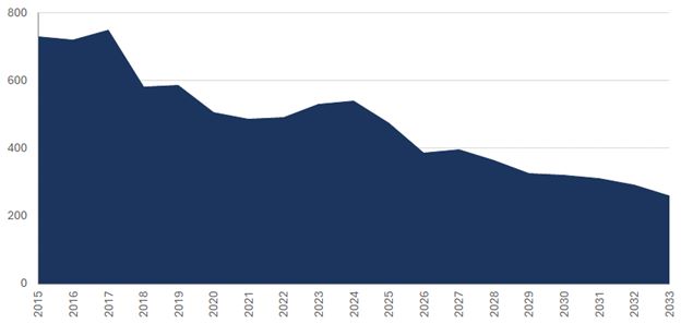
Figure 17: Global rutile supply outlook (kt), by Sovereign Metals, Feb. 2024
Page 64 of 89
IPERIONX TITAN PROJECT, TENNESSEE – TECHNICAL REPORT SUMMARY
Titanium minerals found in the Titan deposit are dominated by rutile and highly altered ilmenite, which are feedstocks for a variety of uses including titanium dioxide, titanium metal and other applications such as
welding and nanomaterials. Natural rutile is a high-grade titanium dioxide feedstock (typical TiO2 content of 92–95%), which commands a significant price premium in the
titanium dioxide market. Ilmenite is also a titanium dioxide feedstock (typical TiO2 content of 58–62%), which can be sold directly to pigment producers or can be used
as a feedstock for synthetic rutile production.
Test work to the Report date indicates that ilmenite minerals in the Titan deposit are likely to be suitable for the chloride ilmenite market, with a TiO2 content >58%. Additionally, the rutile product has the potential to be a high-grade feedstock, with a TiO2 content >90%.
In December 2021, IperionX entered a Memorandum of Understanding with The Chemours Company (Chemours) for the supply of the titanium feedstocks ilmenite and rutile from the Titan Project to Chemours.
Chemours is one of the world’s largest producers of high-quality titanium dioxide products for coatings, plastics, and laminates, with a nameplate titanium dioxide capacity of 1,250,000 tons globally, including New
Johnsonville, Tennessee, located 20 miles from IperionX’s Titan Project, and DeLisle, Mississippi, located 1,100 miles by back haul barge on the Mississippi River.
The Memorandum of Understanding contemplates the commencement of negotiations of a supply agreement between IperionX and Chemours for an initial five-year term on an agreed market based pricing methodology for the
annual supply of up to 50,000 tons of ilmenite and 10,000 tons of rutile.
| 11.10.3.1.3 |
Zircon Products
|
Zircon is an opaque, hard mineral widely used in the production of ceramics, where it provides whiteness, strength and corrosion resistance, including in tiles, sinks, sanitary ware and tableware. Refractory linings
and foundry castings also utilize zircon in their manufacturing to provide chemical and corrosion resistance. Zircon can also be used as a feedstock for production of zirconium metal, used in many advanced industries including clean energy, health
and aerospace, with two zirconium metal producers currently operating in the US.
Test work to the Report date indicates that zircon minerals in the Titan deposit are likely to be suitable for the premium zircon market, with a ZrO2+HfO2 content >65%, and has the potential to be sold into the domestic US zircon premium market.
The global supply of zircon is forecast to decline due to mine depletions, with new projects required to meet predicted demand. There is no meaningful new capacity forecast in the near term, and market conditions
remain extremely tight.
In February 2022, IperionX entered a Memorandum of Understanding with Mario Pilato BLAT S.A. (Mario Pilato) for the potential supply of zircon products.
Mario Pilato is a leading international supplier of raw materials for ceramics, glass and refractories, headquartered in Valencia, Spain.
The Memorandum of Understanding contemplates the commencement of negotiations of a supply agreement between IperionX and Mario Pilato for an initial five-year term on an agreed market based pricing methodology for
the annual supply of up to 20,000 tons of zircon products from the Titan Project.
| 11.10.3.2 |
Preliminary Product Specifications Based on Project Metallurgical Test Work
|
The final products, ilmenite, rutile, zircon, rare earth mineral concentrate, were produced from 2023 test work.
Ilmenite graded 64.9% TiO2 and the rutile graded 91.2% TiO2.
The zircon graded 66.8% ZrO2. The rare earth mineral concentrate had a total rare earth oxide (TREO) grade of 59.1%. The product grades are considered to reflect
saleable products.
Page 65 of 89
IPERIONX TITAN PROJECT, TENNESSEE – TECHNICAL REPORT SUMMARY
| 11.10.3.3 |
Commodity Pricing
|
IperionX previously engaged Adamas Intelligence, an independent research and advisory consultant focused on strategic metals and minerals, to provide a pricing methodology and price forecast for the rare earth
concentrates that could be produced at the Titan Project. The pricing methodology is based upon Adamas’ forecast pricing of IperionX’s rare earth concentrates with reference to the value of rare earth oxides contained, with a premium applied by
Adamas for the specific rare earth oxide enrichment, including heavy rare earths, contained within the Titan Project product.
IperionX used commodity pricing based upon forecasts from TZ Minerals International Pty Ltd (TZMI) for ilmenite, rutile and zircon products, adjusted for economic factors. TZMI is a global independent consulting and
publishing company that specializes in all aspects of the mineral sands, titanium dioxide and coatings industries, particularly the titanium and zirconium value chains.
The rutile, ilmenite, and zircon product prices used in resource estimate refer to the annual average forecast price (base scenario) from years 2026–2050, with long term pricing applied from 2028 onwards. Rare earth
mineral concentrate price is based on the methodology prepared by Adamas Intelligence, with long term pricing applied from 2040 onwards. Tables 9, 10 & 11 summarize historical and forecast prices.
Table 9: Historic and forecast product prices (US$/t, 2024 real terms, rounded)
|
Product
|
Historic 2019–2023
(annual average, US$/t)
|
Forecast 2026–2050
(annual average, US$/t)
|
|
|
Rare earth concentrate
|
6,150
|
11,630
|
|
|
Rutile
|
1,700
|
1,440
|
|
|
Chloride ilmenite
|
280
|
280
|
|
|
Zircon (premium)
|
1,820
|
1,680
|
Source: Argus Media, TZMI, and Adamas Intelligence. Inflationary/CPI data from US Government’s Fiscal Year 2025 Budgetary assumptions.
Table 10: Historic and forecast individual rare earth element prices (US$/kg, 2024 real terms, rounded)
|
Rare Earth Oxide
|
Historic 2019–2023
(annual average, US$/kg)
|
Forecast 2026–2050
(annual average, US$/kg)
|
|
|
Lanthanum
|
1.3
|
1.4
|
|
|
Cerium
|
1.3
|
1.5
|
|
|
Praseodymium
|
78.9
|
157.9
|
|
|
Neodymium
|
80.0
|
166.1
|
|
|
Samarium
|
2.3
|
4.0
|
|
|
Europium
|
30.0
|
39.5
|
|
|
Gadolinium
|
40.0
|
86.4
|
|
|
Terbium
|
1,157.3
|
1,764.9
|
|
|
Dysprosium
|
322.0
|
555.0
|
|
|
Holmium
|
102.4
|
199.3
|
|
|
Erbium
|
33.6
|
57.2
|
|
|
Ytterbium
|
14.6
|
18.3
|
|
|
Lutetium
|
743.5
|
954.2
|
|
|
Yttrium
|
5.9
|
8.0
|
Source: Argus Media and Adamas Intelligence
Page 66 of 89
IPERIONX TITAN PROJECT, TENNESSEE – TECHNICAL REPORT SUMMARY
Table 11: Key product specifications of Titan-derived rare earth mineral concentrate from 2023 test work
|
Rare Earth
|
Concentration (weight %)
|
||
|
La
|
11.28
|
||
|
Ce
|
24.20
|
||
|
Pr
|
2.96
|
||
|
Nd
|
10.87
|
||
|
Sm
|
1.97
|
||
|
Eu
|
0.15
|
||
|
Gd
|
1.43
|
||
|
Tb
|
0.19
|
||
|
Dy
|
0.87
|
||
|
Ho
|
0.15
|
||
|
Er
|
0.38
|
||
|
Tm
|
0.05
|
||
|
Yb
|
0.31
|
||
|
Lu
|
0.04
|
||
|
Y
|
4.23
|
||
|
TREO
|
59.08
|
Pricing has been based upon the following standard product specification requirements:
| • |
Rare earth mineral concentrate: Rare earth mineral concentrate with 59.08 weight % total rare earth oxides (TREO) – as set out in Table 12. Value of rare earth concentrate calculated as 31% value of contained total rare earth oxides plus
10% premium for Titan Project’s heavy rare earth enrichment.
|
| • |
Rutile: bulk rutile with titanium dioxide content (TiO2) of 94–96%.
|
| • |
Chloride ilmenite: chloride ilmenite with titanium dioxide content (TiO2) of 58–65%.
|
|
•
|
Zircon (premium): premium bulk zircon with ZrO2 + HfO2 >66%.
|
| 11.10.4 |
Cut-off Grade
|
All material at/or above the bottom cut-off grade of 0.4%THM used in a constraining pit shell is expected to be processed, on the basis that the incremental cost of selectively extracting this material, hauling it to
a long-term stockpile, and subsequently reclaiming and re-placing the material into a mine void for progressive rehabilitation would be higher than the net cost (operating cost less revenue) of the central case method, being the processing of this
material, extracting the contained valuable critical minerals for sale and immediately returning the remaining material, mostly silica sand, back to the deposit void
KGS considers those blocks within the constraining resource pit shell and above the cut-off applied to have reasonable prospects for economic extraction.
| 11.10.5 |
QP Statement
|
KGS is of the opinion that any issues that arise in relation to relevant technical and economic factors likely to influence the prospect of economic extraction can be resolved with additional work. There is
sufficient time before a final decision is made to develop the Project for IperionX to address any issues that may arise, or perform appropriate additional drilling, test work and engineering studies to mitigate identified issues with the mineral
resource estimate.
| 11.11 |
Mineral Resource Statement
|
Mineral resources are reported using the mineral resource definitions set out in SK1300. The reference point for the estimate is in situ.
Mineral resources are current as at June 30, 2024.
The third-party firm responsible for the estimate is KGS.
The mineral resource estimates are provided in Table 12.
Page 67 of 89
IPERIONX TITAN PROJECT, TENNESSEE – TECHNICAL REPORT SUMMARY
Table 12: Mineral resource estimate and total heavy minerals assemblage
|
Mineral
Resource
Estimate
|
Cut off
|
Tons
|
Total
Heavy
Minerals
|
Total Heavy
Minerals
|
Zircon
|
Rutile
|
Ilmenite
|
Rare
Earth
Elements
|
|
|
(THM %)
|
(Mt)
|
(%)
|
(Mt)
|
(%)
|
(%)
|
(%)
|
(%)
|
||
|
Indicated
|
0.4
|
241
|
2.2
|
5.3
|
11.3
|
9.3
|
39.7
|
2.1
|
|
|
Inferred
|
0.4
|
190
|
2.2
|
4.2
|
11.7
|
9.7
|
41.2
|
2.2
|
Notes to accompany mineral resource table:
| 1. |
Mineral resources are reported using the definitions set out in Regulation S-K 1300 and are current as at June 30, 2024. Mineral resources are reported in situ.
|
| 2. |
The third-party firm responsible for the estimate is Karst Geo Solutions LLC.
|
| 3. |
Mineral resources are reported within a conceptual pit shell that uses the following key assumptions: rutile prices of US$1,440/t; ilmenite prices of US$280/t; rare earth mineral concentrate prices of US$11,630/t; zircon prices of
US$1,680/t; metallurgical recoveries: rutile of 66.9%, ilmenite of 79.7%, rare earth mineral concentrate of 82.6%, zircon of 77.6%; mining costs of US$2.66/t run-of-mine; processing costs of US$2.91/t run-of-mine, transport cost of
US$0.22/t run-of-mine, general and administrative costs of US$0.71/t run-of-mine, reclaim/rehandle cost of US$2.66/t run-of-mine (only used for selective mining comparison) and incremental in pit management cost of 1.00$/t run-of-mine (only
used for selective mining comparison) and royalty of 5%.
|
| 4. |
Mineral resources are reported above a cut-off grade of 0.4% THM.
|
| 5. |
Estimates have been rounded.
|
| 11.12 |
Factors That May Affect the Mineral Resource Estimates
|
Specific factors that may affect the estimates include:
| • |
Changes to forecast commodity and final product price assumptions.
|
| • |
Changes in local interpretations of mineralization geometry such as the presence of unrecognized mineralization, faults, and continuity of mineralized zones.
|
| • |
Changes to metallurgical recovery assumptions.
|
| • |
Changes to assumptions as to deleterious elements.
|
| • |
Changes to the input assumptions used to derive the conceptual open pit shell that is used to constrain the estimates.
|
| • |
Changes to the cut-off values applied to the estimates.
|
| • |
Variations in geotechnical, hydrogeological and mining assumptions
|
| • |
Changes to environmental, permitting and social license assumptions.
|
Page 68 of 89
IPERIONX TITAN PROJECT, TENNESSEE – TECHNICAL REPORT SUMMARY
| 12 |
Mineral Reserve Estimate
|
This section is not relevant to this report.
Page 69 of 89
IPERIONX TITAN PROJECT, TENNESSEE – TECHNICAL REPORT SUMMARY
| 13 |
Mining Methods
|
This section is not relevant to this report.
Page 70 of 89
IPERIONX TITAN PROJECT, TENNESSEE – TECHNICAL REPORT SUMMARY
| 14 |
Processing and Recovery Methods
|
This section is not relevant to this report.
Page 71 of 89
IPERIONX TITAN PROJECT, TENNESSEE – TECHNICAL REPORT SUMMARY
| 15 |
Infrastructure
|
This section is not relevant to this report.
Page 72 of 89
IPERIONX TITAN PROJECT, TENNESSEE – TECHNICAL REPORT SUMMARY
| 16 |
Market Studies
|
This section is not relevant to this report.
Page 73 of 89
IPERIONX TITAN PROJECT, TENNESSEE – TECHNICAL REPORT SUMMARY
| 17 |
Environmental Studies, Permitting, and Plans, Negotiations, or Agreements with Local Individuals or Groups
|
This section is not relevant to this report.
Page 74 of 89
IPERIONX TITAN PROJECT, TENNESSEE – TECHNICAL REPORT SUMMARY
| 18 |
Capital and Operating Costs
|
This section is not relevant to this report.
Page 75 of 89
IPERIONX TITAN PROJECT, TENNESSEE – TECHNICAL REPORT SUMMARY
| 19 |
Economic Analysis
|
This section is not relevant to this report.
Page 76 of 89
IPERIONX TITAN PROJECT, TENNESSEE – TECHNICAL REPORT SUMMARY
| 20 |
Adjacent Properties
|
No proprietary information associated with neighboring properties was used as part of this study.
Page 77 of 89
IPERIONX TITAN PROJECT, TENNESSEE – TECHNICAL REPORT SUMMARY
| 21 |
Other Relevant Data and Information
|
No other relevant data exists at this time.
Page 78 of 89
IPERIONX TITAN PROJECT, TENNESSEE – TECHNICAL REPORT SUMMARY
| 22 |
Interpretation and Conclusions
|
KGS notes the following:
| 22.1 |
Mineral Tenure, Surface Rights, Water Rights, Royalties and Agreements
|
The Project is owned by IperionX Critical Minerals, LLC., a wholly owned subsidiary of IperionX Limited.
As of June 30, 2024, the Titan Project comprised approximately 11.0 km2 (2,726 acres) of surface and associated mineral rights in Tennessee, of which approximately
4.9 km2 (1,211) acres are owned by IperionX, approximately 1.0 km2 (242 acres) are
subject to long-term lease by IperionX, and approximately 5.2 km2 (1,273 acres) are subject to exclusive option agreements with IperionX. These exclusive option
agreements, upon exercise, allow IperionX to the surface property and associated mineral rights.
IperionX has acquired surface, subsurface and water rights to the properties within the resource area.
Upon exercise, in the case of an option to lease, IperionX will pay an annual minimum royalty, generally $75 per acre, and a mining royalty, generally 5% of net revenues from products sold on all leased properties. All properties owned by
IperionX or its subsidiary (TN Exploration, LLC.) will not incur a royalty.
Environmental studies were completed from 2020 to 2022 covering aspects such as: Critical Issue Analysis, United States Army Corps of Engineers Wetland Delineation and Tennessee Department of Environment and Conservation Hydrologic Determination
Field Work, Federally and State Threatened and Endangered Habitat Survey, Cultural Resources Background Research and Baseline Groundwater and Surface Water Study.
Tennessee Department of Environment and Conservation (TDEC) granted IperionX the required state Surface Mining Permit (OM-70711-01) and National Pollutant Discharge Elimination System Permit (TN0070711) on 14 August 2023. TN Surface Mining
Permit is a five-year permit and will need to be renewed and updated every five years. The first renewal will be required by 14 August 2028.
TDEC also determined that IperionX’s proposed sand processing operations would constitute an insignificant activity or insignificant emissions unit, as defined in part 1200-03-09-.04(2)(a)3. of the Tennessee Air Pollution Control Regulations.
TDEC has confirmed that all regulatory permit requirements for the Titan Project phase 1 have been met by IperionX.
IperionX has actively engaged with TDEC, Tennessee Valley Authority, TN state government officials, community members, business owners, local government officials, local school systems, universities, technical schools, local and state government
groups. IperionX will continue identifying and engaging with new groups and stakeholders.
To the extent known to the QP, there were no other significant factors and risks that may affect access, title, or the right or ability to perform work on the Project that were not discussed in this Report.
| 22.2 |
Geology and Mineralization
|
An exploration program that uses the “Heavy Mineral Sands in Coastal Environments” model is considered acceptable for exploration purposes in the Project area.
The Project’s location in western Tennessee represents the eastern flank of the Mississippi Embayment, a large, southward-plunging syncline within the Gulf Coastal Plain.
The McNairy Formation represents a pro-grading deltaic environment during a regressive marine sequence. This is evidenced by the coarsening upward sequence grading from the glauconitic clay-rich Coon Creek Formation to the finer grained lower
member of the McNairy Formation to the coarser grained upper member of the McNairy Formation.
Page 79 of 89
IPERIONX TITAN PROJECT, TENNESSEE – TECHNICAL REPORT SUMMARY
The geological understanding of the settings, lithologies, controls on mineralization is sufficient to support estimation of mineral resources
| 22.3 |
Exploration and Drilling
|
Drilling on the Project area comprises162 drill holes, this includes 16 reverse circulation holes (837 m) and 146 roto-sonic drill holes (5415 m).
All drilling was completed by IperionX.
There are an additional 11 roto-sonic drill holes completed for the purposes as part of a hydrogeological study by HDR. These holes were drilled on IperionX’s behalf and not used for resource definition purposes.
The mineral resource database was closed as at 04-August-2021 and included 107 roto-sonic drill holes (4,101 m). The area covered by the drilling is roughly 6.2 km (north) by 3.6 km (east); the area that hosts the mineral resource estimate is
further broken up into several areas based on land holdings (land agreements). These range from 0.5 km (north) by 0.9 km (east) for the smallest area to 5.1 km (north) by 3.6 km (east) for the largest area. Drill hole spacing is generally 150 x
300 m. Some areas had difficult access and drill spacing in those areas is wider spaced, approximately up to 300 x 600 m.
A total of 66 drill holes were excluded from the mineral resource estimation. This included 39 roto-sonic exploration holes that the results were received after the database cut-off date, 11 holes that were drilled in association with a
hydrogeological study, and 16 reverse circulation drill holes because of the high likelihood of down hole sample contaminations.
All drilling for the Project that is used in mineral resource estimation is roto sonic.
| 22.4 |
Sampling and Analysis
|
Roto-sonic drill core samples, typically 3 m in length, were collected directly from the plastic sample sleeve at the drill site. Some interpretation was involved as the material could expand or compact as it was recovered from the core barrel
into the plastic sleeve. Samples were collected at regular 1.5 m, intervals unless geological contacts were encountered. Sample length ranged from 0.3 m to 4.5 m. The samples that were not consistent with the 1.5 m sampling interval accounted for
0.05% of all samples.
The unconsolidated sonic cores were sampled by splitting the core in half lengthwise using a machete, then recovering an even fillet with a trowel along the entire length of the sample interval. The sample volume was about 2 kg and was
appropriate for the analytical method(s) being used and ensured adequate sample volume was collected. Samples were collected directly to pre-labeled/pre-tagged sample bags; the remaining sample was further split into a replicate/archival sample.
What sample remained after these steps was used to backfill the drill hole.
Sample bags were sealed with a zip tie at the drill site, placed in rice bags, and remained in the custody of the field geologist from time of collection until time of delivery to the Project’s temporary storage location. This was either a
secure third-party storage unit or a leased barn. A red security tag was used to secure the top of each rice bag, and these tags were verified by the laboratory to confirm all sample bags were intact when delivered to the laboratory.
Drill samples were sent to SGS Lakefield. SGS Lakefield is a qualified third-party laboratory that is independent of IperionX. SGS Lakefield is accredited as an ISO 17025 facility for selected analytical techniques.
Samples were subjected to standard mineral sand industry assay procedures of size fraction analysis, heavy-liquid separation, and chemical analysis.
Accuracy monitoring was addressed by submission of in-house heavy mineral sand standard developed specifically for the Project. There is no commercially available standard reference material for heavy mineral sand. It is an industrial standard
to generate standards that represent a matrix match to the target material being analyzed.
Page 80 of 89
IPERIONX TITAN PROJECT, TENNESSEE – TECHNICAL REPORT SUMMARY
The sample preparation, analysis, quality control, and security procedures are acceptable for mineral resource estimation. The sample preparation, analysis, quality control, and security procedures are sufficient to provide reliable data to
support estimation of mineral resources.
| 22.5 |
Data Verification
|
KGS conducted several site visits throughout the drilling campaigns and metallurgical test programs. KGS also visited the Mineral Technologies laboratory SGS Lakefield. These visits are discussed in Chapter 2.4.
The site visits provided visual confirmation of mineralization, drill hole locations, bulk sample collection and logging and sampling procedures. KGS is satisfied with the laboratory procedures as witnessed during the Mineral Technologies
laboratory inspection. The laboratory procedures witnessed during the KGS inspection of SGS Lakefield are considered acceptable.
KGS provided training on logging, sampling, material interpretations and density measurements. KGS and IperionX staff had regular database validations to ensure data quality was sufficient
The QP is of the opinion that the data are of a high quality and that no systemic or procedural issues that could impact the exploration results or mineral resource estimation are present that have not been discussed in this Report.
| 22.6 |
Metallurgical Testwork
|
Two test work programs were conducted within mineral resource area, one in 2021 and the second in 2023. All test work was completed on behalf of IperionX.
Test work was completed by, or under the supervision of, Mineral Technologies. The company is a reputable testing organization, with laboratories with significant experience in mineral sands flowsheet development located in Florida, and in
Queensland, Australia. The laboratories are ISO 9001, 45001 and 14001 accredited. Mineral Technologies is independent of IperionX. A portion of the test work was completed at IperionX’s Camden mineral demonstration facility, under the
supervision of Mineral Technologies personnel. Neither facility is accredited for metallurgical test work procedures; this is routine for metallurgical testing facilities as there is currently nobody that certifies laboratories specifically for
metallurgical test work.
Assays were conducted by SGS Lakefield, and Bureau Veritas in Perth, Australia, using X-ray fusion (XRF), laser ablation/inductively-couple plasma mass spectrometry (ICP–MS) and QEMSCAN analytical methods. Bureau Veritas is independent of
IperionX and holds ISO 17025 accreditations for selected analytical techniques.
The final products, ilmenite, rutile, zircon, rare earth mineral concentrate, were produced from the 2023 test work. Ilmenite graded 64.9%TiO2, and the rutile graded
91.2% TiO2. The zircon graded 66.8% ZrO2. The rare earth mineral concentrate had a TREO
grade of 59.1%. The product grades generally align with 2021 scoping test work results and were considered to be saleable products.
The test work showed that high-quality ilmenite, rutile, zircon products could be achieved using conventional separation equipment through a typical wet concentrator plant and fine and coarse mineral separation plant flowsheet. A rare earth
mineral concentrate product was created at a high monazite recovery using a wet rare earth mineral concentrate circuit.
Circuit simulation models were generated for the wet concentration plant, rare earth mineral plant and mineral separation plant flowsheets to evaluate recycle streams and resultant mass flows. The expected future performance of the processing
plant was based on metallurgical test work results and benchmarked against other deposits that have similar characteristics to the Titan deposit. The simulated recoveries for in-size sample (+45 μm material) from ROM to products are:
| • |
Rare earth mineral recovery of 82.6%.
|
| • |
Ilmenite recovery of 79.7%.
|
Page 81 of 89
IPERIONX TITAN PROJECT, TENNESSEE – TECHNICAL REPORT SUMMARY
| • |
Rutile recovery of 66.9%.
|
| • |
Zircon recovery of 77.6%.
|
The metallurgical testwork results and recovery forecasts support the estimation of mineral resources.
| 22.7 |
Mineral Resource Estimates
|
The mineral resource estimate is reported using the definitions set out in SK-1300. The reference point for the estimate is in situ. The estimate is based on sonic drilling, total heavy mineral assays, and composite mineralogy data.
The Titan deposit block models were estimated using nearest neighbor, inverse distance weighting to the second power, and ID3. The ID3 method was used for the public reporting of the mineral resource estimate.
The resource classification was determined based on drill hole density reflecting the geological confidence.
Reasonable prospects of eventual economic extraction were addressed through assessment of initial assessment criteria and confining of the mineral resources in a conceptual pit shell. IperionX had completed internal studies that reviewed
potential mining methods, infrastructure locations, and process methods. KGS reviewed these studies when determining appropriate assumptions in support of reasonable prospects for economic extraction.
Material considered to meet reasonable prospects for economic extraction was reported using a cut-off grade of 0.4% THM.
Specific factors that may affect the estimates include:
| • |
Changes to forecast commodity and final product price assumptions.
|
| • |
Changes in local interpretations of mineralization geometry such as the presence of unrecognized mineralization, faults, and continuity of mineralized zones.
|
| • |
Changes to metallurgical recovery assumptions.
|
| • |
Changes to assumptions as to deleterious elements.
|
| • |
Changes to the input assumptions used to derive the conceptual open pit shell that is used to constrain the estimates.
|
| • |
Changes to the cut-off values applied to the estimates.
|
| • |
Variations in geotechnical, hydrogeological and mining assumptions
|
| • |
Changes to environmental, permitting and social license assumptions.
|
| 22.8 |
Risks and Opportunities
|
| 22.8.1 |
Risks
|
The Project is subject to certain risks including but not limited to: commodity prices, unanticipated inflation of costs, geological uncertainty, geotechnical and hydrologic studies.
Deleterious elements such as iron, magnesium, uranium, thorium, chromium, and vanadium can negatively impact the marketability of heavy mineral sands products, especially uranium and thorium for the Project. High levels of these contaminants may
reduce product quality, result in regulatory penalties, or require additional processing, which increases costs. Environmental considerations, particularly tailings management and the potential presence of radioactive or toxic elements, can add
complexity and expenses due to stricter regulations, water management, and the need for site rehabilitation after mining operations.
There is also a risk that the conceptual project infrastructure locations that were assumed in the Initial Assessment would not be able to be constructed where provisionally envisaged, and additional studies would be required.
Page 82 of 89
IPERIONX TITAN PROJECT, TENNESSEE – TECHNICAL REPORT SUMMARY
| 22.8.2 |
Opportunities
|
Opportunities for the Project include:
| • |
Upgrade of some or all of the inferred mineral resources to higher-confidence categories, such that such better-confidence material could be used in mineral reserve estimation
|
| • |
Higher product prices than assumed could present upside opportunities
|
| 22.9 |
Conclusions
|
Under the assumptions presented in this Report, the Titan Project represents a substantial mineral resource that warrants technical evaluation and studies.
Additional work is justified on the Project to upgrade the mineral resource confidence categories.
Page 83 of 89
IPERIONX TITAN PROJECT, TENNESSEE – TECHNICAL REPORT SUMMARY
| 23 |
Recommendations
|
The recommended work programs from KGS include:
| • |
Environmental baseline studies. A budget estimate for this work is approximately US$ 1 million.
|
| • |
Geotechnical investigations for process plant, mine pit side wall slopes and tailings stabilization; A budget estimate for this work is approximately US$ 0.8 million.
|
| • |
Hydrogeologic assessment and hydrogeologic model update based on mine plan; A budget estimate for this work is approximately US$ 0.2 million.
|
| • |
Trade-off studies for plant location and product suits; sediment and erosion control design; mining method and mine design; mineral reserve estimate; material characterization of overburden and tailing materials and tails design; overall
site water balance and management plan; A budget estimate for this work is approximately US$ 1 million.
|
| • |
Process plant design and infrastructure design; risk review; capital cost estimate and operating cost estimate; financial model etc. A budget estimate for this work is approximately US$ 2 million.
|
| • |
Overall project management and third-party review. A budget estimate for this work is approximately US$ 1 million.
|
The estimated total budget for the above work programs is approximately US$6 million.
Page 84 of 89
IPERIONX TITAN PROJECT, TENNESSEE – TECHNICAL REPORT SUMMARY
| 24 |
References
|
| 24.1 |
Bibliography
|
| • |
Mineral Technologies Report, Titan Mineral Sands Project, Flowsheet Development and Performance Simulation, MS23/3702611/1, Rev.1, April 21, 2023.
|
| • |
Mineral Technologies Report, Titan Mineral Sands Project, Metallurgical Feasibility Testwork for Wet Gravity, Rare-earth Mineral Flotation and Dry Physical Separation to Produce Concentrate of Zircon, Monazite and Titanuim Minerals,
MS22/3702611/1, Rev.1, April 21, 2023.
|
| • |
HDR, IperionX Groundwater Flow Model, Dec.14, 2022
|
| • |
HDR, Technical Memo, IperionX Baseline Groundwater and Surface Water Assessment, July 15, 2022.
|
| • |
IperionX Titan Project Technical Report Summary, June 30, 2022.
|
| • |
Primero Scoping Study Report, Titan Heavy Mineral Sands Project, 40501-REP-GE-002, June 2022.
|
| • |
Mineral Technologies Report, Titan Mineral Sands Project – Benton Ore, Conventional Wet Gravity and Dry Physical Separation Testwork Including Creation of Ilmenite, Rutile, Zircon, and Monazite Concentrate from Provided Ore Samples,
MTNA21069, Rev.2, September 22, 2021.
|
| • |
Mineral Technologies Report, Titan Mineral Sands Project – Camden Ore, Scoping Testwork for Wet Gravity, Rare Earth Mineral Flotation and Dry Physical Separation to Produce Concentrates of Zircon, Monazite and Titanium Minerals,
MS21/3394979/1, Rev.2, February 16, 2022.
|
| • |
IperionX, ASX Release, Maiden Resource Confirms Tennessee as Major Untapped Critical Mineral Province, October 6, 2021.
|
| 24.2 |
Abbreviations, Acronyms and Units of Measure
|
Table 2: Abbreviations, acronyms and units of measure.
|
Symbol
|
Description
|
||
|
COG
|
Cut Off Grade
|
||
|
CUP
|
Concentrate Upgrade Plant
|
||
|
FPP
|
Feed Preparation Plant
|
||
|
HDR
|
HDR Engineering, Inc.
|
||
|
HLS
|
Heavy Liquid Separation
|
||
|
HM
|
Heavy Minerals
|
||
|
HMC
|
Heavy Mineral Concentrate
|
||
|
HMS
|
Heavy Mineral Sand
|
||
|
HTR
|
High Tension Rolls
|
||
|
ICP
|
Inductively Coupled Plasma
|
||
|
KGS
|
Karst Geo Solutions, LLC
|
||
|
MDF
|
Mineral Demonstration Facility
|
||
|
MMU
|
Mobile Mining Unit
|
||
|
MSP
|
Mineral Separation Plant
|
||
|
MRE
|
Mineral Resource Estimate
|
Page 85 of 89
IPERIONX TITAN PROJECT, TENNESSEE – TECHNICAL REPORT SUMMARY
|
MUP
|
Mining Unit Plant
|
||
|
NPDES
|
National Pollutant Discharge Elimination System
|
||
|
OS
|
Oversize
|
||
|
QEMSCAN
|
Quantitative Evaluation of Materials by Scanning Electron Microscopy
|
||
|
REMC
|
Rare Earth Mineral Concentrate
|
||
|
REMP
|
Rare Earth Mineral Plant
|
||
|
ROM
|
Run of Mine
|
||
|
SL
|
Slimes
|
||
|
MT
|
Metric Ton
|
||
|
TRS
|
Technical Report Summary
|
||
|
TREO
|
Total Rare Earth Oxide
|
||
|
TDEC
|
Tennessee Department of Environment & Conservation
|
||
|
$
|
United States Dollars
|
||
|
UTIA
|
University of Tennessee’s Institute of Agriculture
|
||
|
XRF
|
X-ray fluorescence
|
||
|
WCP
|
Wet Concentration Plant
|
| 24.3 |
Glossary of Terms
|
|
Term
|
Definition
|
|||
|
concentrate
|
The concentrate is the valuable product from mineral processing, as opposed to the tailing, which contains the waste minerals.
|
|||
|
cut-off grade
|
A grade level below which the material is not “ore” and considered to be uneconomical to mine and process.
|
|||
|
data verification
|
The process of confirming that data has been generated with proper procedures, has been accurately transcribed from the original source and is suitable to be used for mineral resource estimation.
|
|||
|
encumbrance
|
An interest or partial right in real property which diminished the value of ownership but does not prevent the transfer of ownership. Mortgages, taxes and judgements are encumbrances known as liens. Restrictions, easements, and
reservations are also encumbrances, although not liens.
|
|||
|
heavy minerals
|
Heavy minerals are defined as minerals having a higher density than quartz, the most common rock-forming soil mineral with a density of 2.65 g/cm3.
|
|||
|
indicated mineral resource
|
An indicated mineral resource is that part of a mineral resource for which quantity and grade or quality are estimated on the basis of adequate geological evidence and sampling. The term adequate geological evidence means evidence that
is sufficient to establish geological and grade or quality continuity with reasonable certainty. The level of geological certainty associated with an indicated mineral resource is sufficient to allow a qualified person to apply modifying
factors in sufficient detail to support mine planning and evaluation of the economic viability of the deposit.
|
|||
Page 86 of 89
IPERIONX TITAN PROJECT, TENNESSEE – TECHNICAL REPORT SUMMARY
|
inferred mineral resource
|
An inferred mineral resource is that part of a mineral resource for which quantity and grade or quality are estimated on the basis of limited geological evidence and sampling. The term limited geological evidence means evidence that is
only sufficient to establish that geological and grade or quality continuity is more likely than not. The level of geological uncertainty associated with an inferred mineral resource is too high to apply relevant technical and economic
factors likely to influence the prospects of economic extraction in a manner useful for evaluation of economic viability.
A qualified person must have a reasonable expectation that the majority of inferred mineral resources could be upgraded to indicated or measured mineral resources with continued exploration; and should be able to defend the basis of this
expectation before his or her peers.
|
|||
|
initial assessment
|
An initial assessment is a preliminary technical and economic study of the economic potential of all or parts of mineralization to support the disclosure of mineral resources. The initial assessment must be prepared by a qualified person
and must include appropriate assessments of reasonably assumed technical and economic factors, together with any other relevant operational factors, that are necessary to demonstrate at the time of reporting that there are reasonable
prospects for economic extraction. An initial assessment is required for disclosure of mineral resources but cannot be used as the basis for disclosure of mineral reserves
|
|||
|
mineral resource
|
A mineral resource is a concentration or occurrence of material of economic interest in or on the Earth’s crust in such form, grade or quality, and quantity that there are reasonable prospects for economic extraction.
The term material of economic interest includes mineralization, including dumps and tailings, mineral brines, and other resources extracted on or within the earth’s crust. It does not include oil and gas resources, gases (e.g., helium
and carbon dioxide), geothermal fields, and water.
When determining the existence of a mineral resource, a qualified person, as defined by this section, must be able to estimate or interpret the location, quantity, grade or quality continuity, and other geological characteristics of the
mineral resource from specific geological evidence and knowledge, including sampling; and conclude that there are reasonable prospects for economic extraction of the mineral resource based on an initial assessment, as defined in this
section, that he or she conducts by qualitatively applying relevant technical and economic factors likely to influence the prospect of economic extraction.
|
|||
|
mineral sands
|
Concentrations of heavy minerals in an alluvial (old beach or river system) environment.
|
|||
|
mineral separation plant
|
Using screening, magnetic, electrostatic and gravity separation circuits to
separate valuable minerals from non-valuable minerals, and to make different ilmenite, rutile, leucoxene and zircon product grades for specific customer requirements.
|
|||
|
open pit
|
A mine that is entirely on the surface. Also referred to as open-cut or open- cast mine.
|
|||
|
reclamation
|
The restoration of a site after mining or exploration activity is completed.
|
|||
|
royalty
|
An amount of money paid at regular intervals by the lessee or operator of an exploration or mining property to the owner of the ground. Generally based on a specific amount per tonne or a percentage of the total production or profits.
Also, the fee paid for the right to use a patented process.
|
|||
Page 87 of 89
IPERIONX TITAN PROJECT, TENNESSEE – TECHNICAL REPORT SUMMARY
|
specific gravity
|
The weight of a substance compared with the weight of an equal volume of pure water at 4°C.
|
|||
|
total heavy minerals
|
Total volume of heavy minerals within a deposit.
|
|||
|
wet concentration plant
|
Utilizing sizing and gravity differentiation between heavy minerals, valuable heavy minerals, clay and quartz to produce a high-grade (between 85 and 98 per cent) heavy mineral concentrate, retaining valuable minerals and minimizing
gangue within the concentrate.
|
Page 88 of 89
IPERIONX TITAN PROJECT, TENNESSEE – TECHNICAL REPORT SUMMARY
| 25 |
Reliance on Information Provided by the Registrant
|
KGS has relied upon the following information supplied by IperionX. KGS considers it is reasonable to rely on IperionX because the company team has considerable experience in
developing and operating mines.
| • |
Markets: Information relating to market studies for different products, market strategies, marketing and sales contracts. This information is used when discussing the market and commodity price which supports the mineral resource
estimate in Chapter 11.
|
| • |
Legal Matters: Information relating to the ownership, the mineral tenure, surface rights, water rights, royalties, encumbrances, permitting requirements. This information is used in support of the property ownership information in
Chapter 3.
|
| • |
Environmental Matters: Information relating to baseline and supporting studies for environmental permitting. This information is used when discussing property ownership information in Chapter 3.
|
| • |
Stakeholder Accommodations: Information relating to community relations. This information is used when discussing property ownership information in Chapter 3.
|
Page 89 of 89